Lobelia, West Virginia

Last updated
Lobelia, West Virginia
Unincorporated community
USA West Virginia location map.svg
Red pog.svg
Lobelia, West Virginia
Usa edcp location map.svg
Red pog.svg
Lobelia, West Virginia
Coordinates: 38°08′01″N80°17′40″W / 38.13361°N 80.29444°W / 38.13361; -80.29444 Coordinates: 38°08′01″N80°17′40″W / 38.13361°N 80.29444°W / 38.13361; -80.29444
Country United States
State West Virginia
County Pocahontas
Elevation 2,503 ft (763 m)
Time zone Eastern (EST) (UTC-5)
  Summer (DST) EDT (UTC-4)
Area code(s) 304 & 681
GNIS feature ID 1551907 [1]

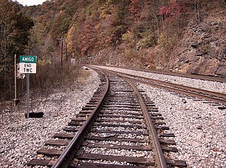
Lobelia is an unincorporated community in Pocahontas County, West Virginia, United States. Lobelia is 4.5 miles (7.2 km) west of Hillsboro.

Unincorporated area Region of land not governed by own local government

In law, an unincorporated area is a region of land that is not governed by a local municipal corporation; similarly an unincorporated community is a settlement that is not governed by its own local municipal corporation, but rather is administered as part of larger administrative divisions, such as a township, parish, borough, county, city, canton, state, province or country. Occasionally, municipalities dissolve or disincorporate, which may happen if they become fiscally insolvent, and services become the responsibility of a higher administration. Widespread unincorporated communities and areas are a distinguishing feature of the United States and Canada. In most other countries of the world, there are either no unincorporated areas at all, or these are very rare; typically remote, outlying, sparsely populated or uninhabited areas.

Pocahontas County, West Virginia County in the United States

Pocahontas County is a county located in the U.S. state of West Virginia. As of the 2010 census, the population was 8,719. Its county seat is Marlinton. The county was established in 1821. It is named after the daughter of the Powhatan Native American chief from Jamestown, Virginia. She married an English settler and their mixed-race children became ancestors of many of the First Families of Virginia.

West Virginia State of the United States of America

West Virginia is a state located in the Appalachian region in the Southern United States that is also considered to be a part of the Middle Atlantic States. It is bordered by Pennsylvania to the north, Maryland to the east and northeast, Virginia to the southeast, Kentucky to the southwest, and Ohio to the northwest. West Virginia is the 41st largest state by area, and is ranked 38th in population. The capital and largest city is Charleston.

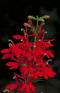
The community was named after the Lobelia flowers near the original town site. [2]

<i>Lobelia</i> genus of plants

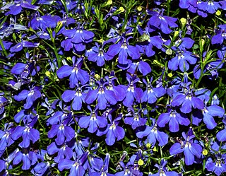
Lobelia is a genus of flowering plants comprising 415 species, with a subcosmopolitan distribution primarily in tropical to warm temperate regions of the world, a few species extending into cooler temperate regions. They are known generally as lobelias.

Related Research Articles

Odd, West Virginia Unincorporated community in West Virginia, United States

Odd is an unincorporated community in Raleigh County, West Virginia, United States. It is located along Tommy Creek.

Emmons, West Virginia Unincorporated community in West Virginia, United States

Emmons is an unincorporated community located on the Big Coal River in Boone and Kanawha Counties in the U.S. state of West Virginia. Jay Rockefeller's political affiliation with West Virginia began in 1964-1965 while he served as a VISTA volunteer in Emmons.

<i>Lobelia cardinalis</i> species of plant

Lobelia cardinalis is a species of flowering plant in the bellflower family Campanulaceae native to the Americas, from southeastern Canada south through the eastern and southwestern United States, Mexico and Central America to northern Colombia.

North River (South Fork Shenandoah River tributary) river in Shenandoah Valley of Virginia, United States

The North River is a 55.3-mile-long (89.0 km) river in the mountains and Shenandoah Valley of northern Virginia, the United States. It joins the South River at Port Republic to form the South Fork Shenandoah River.

Isaban, West Virginia Unincorporated community in West Virginia, United States

Isaban is an unincorporated community located on Fourpole Creek, in McDowell and Mingo counties in the U.S. state of West Virginia.

Belva, West Virginia Census-designated place in West Virginia, United States

Belva is an unincorporated community and census-designated place in west Nicholas County and north Fayette County, West Virginia, United States; while the CDP only includes the Nicholas County portion, the Fayette County portion is considered part of the community. The town is situated at the bottomland surrounding the convergence of Bells Creek with Twentymile Creek and, subsequently, Twenty Mile Creek with the Gauley River. Belva is also the location of the convergence of two state highways: West Virginia Route 16 and West Virginia Route 39.

Amigo, West Virginia Unincorporated community in West Virginia, United States

Amigo is an unincorporated community in Raleigh County, West Virginia, United States. The community is located on West Virginia Route 16 at the confluence of the Guyandotte River and Winding Gulf. The Amigo Post Office closed on 10/22/2011, it was established in 1915 The community most likely derives its name from the Amigo Coal Company.

<i>Lobelia urens</i> species of plant

Lobelia urens has the English name of heath lobelia or acrid lobelia. It has a Lusitanian distribution running from Morocco along the Atlantic Coast to Belgium. It can be found in the islands of south Europe: Madeira, Tercia, Falia, Gibraltar. In Spain it is found in grazed pasture of upland valleys between 600 and 915 metres high. In Portugal it exists along the coastal plain, passing into the wet northern province valleys up to 800 metres. In north France it is found in lowland coastal areas. It is rare in Britain and found in South and South West of England in lowland areas up to 210 metres high. It is not threatened in Europe.

Dickinson, West Virginia Unincorporated community in West Virginia, United States

Dickinson, also known as Quincy, is an unincorporated community in Kanawha County, West Virginia, United States. Dickinson is located on the north bank of the Kanawha River 3 miles (4.8 km) southeast of Belle. The community is served by U.S. Route 60.

Corton, West Virginia Unincorporated community in West Virginia, United States

Corton is an unincorporated community in Kanawha County, West Virginia, United States. Corton is located on the Elk River and West Virginia Route 4 4 miles (6.4 km) east of Clendenin.

MacDonald, West Virginia Unincorporated community in West Virginia, United States

MacDonald is an unincorporated community and coal town in Fayette County, West Virginia, United States.

Olcott, West Virginia Unincorporated community in West Virginia, United States

Olcott is an unincorporated community and coal town in Kanawha County, West Virginia, United States. Its post office is closed.

Wickham, West Virginia Unincorporated community in West Virginia, United States

Wickham is an unincorporated community in Raleigh County, West Virginia, United States. Its post office is closed.

Weir, West Virginia Unincorporated community in West Virginia, United States

Weir is an unincorporated community in Kanawha County, West Virginia, United States. Its post office is called Falling Rock.

Legg, West Virginia Unincorporated community in West Virginia, United States

Legg is an unincorporated community in Kanawha County, West Virginia, United States. Its post office is closed.

Rensford, West Virginia Unincorporated community in West Virginia, United States

Rensford is an unincorporated community in Kanawha County, West Virginia, United States. Its post office is closed. It was also known as Point Lick.

Wevaco, West Virginia Unincorporated community in West Virginia, United States

Wevaco is an unincorporated community and former coal town in Kanawha County, West Virginia, United States. Its post office is closed.

Lobelia is a genus of flowering plants.

References