
Pocahontas County is a county located in the eastern part of the U.S. state of West Virginia. As of the 2020 census, the population was 7,869. Its county seat is Marlinton. The county was established in 1821. It is named after the daughter of the Powhatan chief of the Native Americans in the United States who came from Jamestown, Virginia. She married an English settler, and their children became ancestors of many of the First Families of Virginia.

Greenbrier County is a county in the U.S. state of West Virginia. As of the 2020 census, the population was 32,977. Its county seat is Lewisburg. The county was formed in 1778 from Botetourt and Montgomery counties in Virginia.

Lewisburg is a city in and the county seat of Greenbrier County, West Virginia, United States. The population was 3,930 at the 2020 census.
Lowell is an unincorporated community in Summers County, West Virginia, United States. Lowell is located on the Greenbrier River, east of Hinton and southwest of Alderson. The community was first settled in 1770 and is the oldest community in Summers County.
Justice is a census-designated place in Mingo County, West Virginia, United States. Justice is located on U.S. Route 52, 2.5 miles (4.0 km) southeast of Gilbert. Justice has a post office with ZIP code 24851. As of the 2010 census, its population was 412.
Raysal is a census-designated place (CDP) in McDowell County, West Virginia, United States. Raysal is located along West Virginia Route 83, 1 mile (1.6 km) southeast of Bradshaw. Raysal has a post office with ZIP code 24879. As of the 2010 census, its population was 465.
Dailey is a census-designated place (CDP) in Randolph County, West Virginia, United States. Dailey is located on U.S. routes 219 and 250, 3 miles (4.8 km) south-southwest of Beverly. Dailey has a post office with ZIP code 26259. As of the 2010 census, its population was 114.
Bowden is a census-designated place (CDP) in Randolph County, West Virginia, United States. Bowden is located on U.S. Route 33, 7.5 miles (12.1 km) east of Elkins. Bowden has a post office with ZIP code 26254. According to the 2010 Census, there were nine people residing at this location.
Hico is a census-designated place (CDP) in Fayette County, West Virginia, United States. Hico is located at the junction of U.S. routes 19 and 60, 7 miles (11 km) northeast of Fayetteville. Hico has a post office with ZIP code 25854. As of the 2010 census, its population was 272.

Mount Carbon is a census-designated place (CDP) in Fayette County, West Virginia, United States. Mount Carbon is located along West Virginia Route 61, 3 miles (4.8 km) southeast of Montgomery, on the south bank of the Kanawha River at the mouth of Armstrong Creek. Mount Carbon has a post office with ZIP code 25139. As of the 2010 census, its population was 428.
Hilltop is a census-designated place (CDP) in Fayette County, West Virginia, United States. Hilltop is located on state routes 16 and 61, 2 miles (3.2 km) south of Oak Hill. Hilltop has a post office with ZIP code 25855. As of the 2010 census, its population was 624.
Kincaid is a census-designated place (CDP) in Fayette County, West Virginia, United States. As of the 2010 census, its population was 260. Kincaid is located on West Virginia Route 61,8 miles (13 km) northwest of Oak Hill. Kincaid has a post office with ZIP code 25119. The community was established in 1878.
Eccles is a census-designated place (CDP) in Raleigh County, West Virginia, United States. Eccles is located on West Virginia Route 3, 4 miles (6.4 km) west of Beckley. Eccles has a post office with ZIP code 25836. As of the 2010 census, its population is 362.
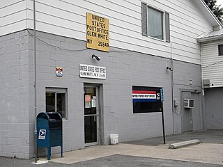
Glen White is a census-designated place (CDP) in Raleigh County, West Virginia, United States. Glen White is located on state routes 54 and 97, 1 mile (1.6 km) southeast of Lester. Glen White had a post office with ZIP code 25849. As of the 2010 census, its population is 266.
Comfort is a census-designated place (CDP) in Boone County, West Virginia, United States. Comfort is located on West Virginia Route 3, 12 miles (19 km) northeast of Madison. Comfort has a post office with ZIP code 25049. As of the 2010 census, its population is 306. Comfort is the home of Sherman Elementary School.
Hepzibah is a census-designated place (CDP) and coal town in Harrison County, West Virginia, United States. It is located on U.S. Route 19 and West Virginia Route 20, 3.5 miles (5.6 km) north of Clarksburg.
Dixie is a census-designated place (CDP) in Fayette and Nicholas counties, West Virginia, United States. Dixie is located on West Virginia Route 16, 5.5 miles (8.9 km) north of Gauley Bridge. Dixie has a post office with ZIP code 25059. As of the 2010 census, its population was 291, with 202 residents in Nicholas County and 89 in Fayette County.
Big Creek is a census-designated place (CDP) in Logan County, West Virginia, United States. Big Creek is located on West Virginia Route 10, 2.5 miles (4.0 km) northwest of Chapmanville. Big Creek has a post office with ZIP code 25505. As of the 2010 census, its population was 237.
Valley Bend is a census-designated place (CDP) in Randolph County, West Virginia, United States. Valley Bend is located on U.S. routes 219 and 250, as well as state routes 55 and 92, 3.5 miles (5.6 km) northwest of Mill Creek. Valley Bend has a post office with ZIP code 26293. As of the 2010 census, its population was 485.
The Camp Bartow Historic District — centered on the historic inn called "Traveller's Repose" and the site of the Battle of Greenbrier River (1861) — is a national historic district located at Bartow, Pocahontas County, West Virginia, United States. It is situated at the foot of Burner Mountain, at a bend in the East Fork Greenbrier River, where U.S. Route 28 intersects U.S. Route 250.


