
Pocahontas County is a county located in Iowa, United States. As of the 2010 census, the population was 7,310. The county seat is Pocahontas. The county was formed in 1851.

Pocahontas is a town in Tazewell County, Virginia, United States. It was named for Chief Powhatan's daughter, Pocahontas, who lived in the 17th-century Jamestown Settlement. She married John Rolfe, and they were among the ancestors of many of the First Families of Virginia.
Pocahontas was a Pamunkey Algonquian chief's daughter from early American history.

The Greenbrier River is a tributary of the New River, 162 miles (261 km) long, in southeastern West Virginia, in the United States. Via the New, Kanawha and Ohio rivers, it is part of the watershed of the Mississippi River, draining an area of 1,656 square miles (4,290 km2). It is one of the longest rivers in West Virginia.

West Virginia Route 66 is an east–west state highway located within Pocahontas County, West Virginia. The route runs 16.1 miles (25.9 km) from U.S. Route 219 and West Virginia Route 55 near Snowshoe east to West Virginia Route 28 and West Virginia Route 92 south of Green Bank. WV 66 is maintained by the West Virginia Division of Highways.

Shavers Fork Mountain Complex is the name given to the mountains on either side of Shavers Fork in the highlands portions of Randolph County, Pocahontas County, and Tucker County in West Virginia, USA. Much of the land surrounding the river and its adjacent mountains is protected by Monongahela National Forest including about 20,000 acres (81 km2) of designated wilderness.

Droop Mountain Battlefield State Park is a state park located on Droop Mountain in Pocahontas County, West Virginia. Droop Mountain was the site of the last major battle of the American Civil War in the state. A West Virginia private in the Union Army at the Battle of Droop Mountain, John D. Sutton, became the leader in the movement to create the park when he served in the West Virginia House of Delegates. Dedicated on July 4, 1928, Droop Mountain Battlefield became the first state park in West Virginia.
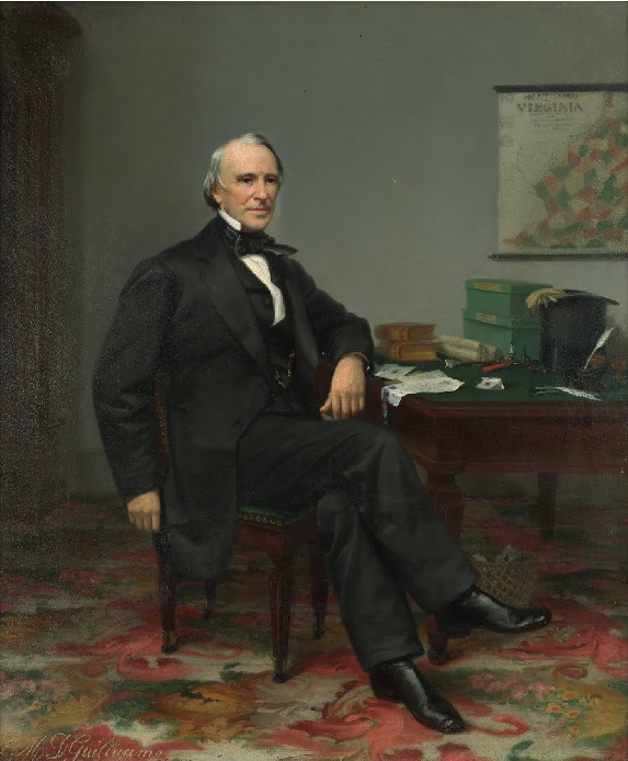
Wyndham Robertson was the Acting Governor of the U.S. state of Virginia from 1836 to 1837. He also twice served multiple terms in the Virginia House of Delegates, the second series representing Richmond during the American Civil War.

The U.S. state of West Virginia was formed out of western Virginia and added to the Union as a direct result of the American Civil War, in which it became the only state to declare its independence from the Confederacy. In the summer of 1861, Union troops, which included a number of newly-formed Western Virginia regiments, under General George McClellan, drove off Confederate troops under General Robert E. Lee. This essentially freed Unionists in the northwestern counties of Virginia to form a functioning government of their own as a result of the Wheeling Convention. Prior to the admission of West Virginia the government in Wheeling formally claimed jurisdiction over all of Virginia, although from its creation it was firmly committed to the formation of a separate state.

Pocahontas Coalfield, which is also known as the Flat Top-Pocahontas Coalfield, is located in Mercer County/McDowell County, West Virginia and Tazewell County, Virginia. The earliest mining of coal in the coalfield was in Pocahontas, Virginia in 1883 at Pocahontas Mine No. 1, now on the National Register of Historic Places.
Allegheny Mountain Radio or AMR is a network of full service, freeform formatted community radio stations broadcasting to portions of West Virginia and Virginia in the United States. The stations serve Pocahontas County in West Virginia and Bath and Highland counties in Virginia.
Droop Mountain is a small mountain in the Allegheny Mountains on the border of Greenbrier and Pocahontas counties in southeastern West Virginia. It was the scene of one of West Virginia's most important battles during the American Civil War—the Battle of Droop Mountain.

This is a list of the National Register of Historic Places listings in Pocahontas County, West Virginia.

Clover Lick is an unincorporated community in Pocahontas County, West Virginia, United States. Clover Lick is located along the Greenbrier River 10 miles (16 km) northeast of Marlinton. The community is home to the Clover Lick Train Depot, which sits along the Greenbrier River Trail at Milepost 71.2. Clover Lick was founded in the early 1900s as a place to board trains traveling along the Greenbrier River.
Boyer is an unincorporated community in Pocahontas County, West Virginia, United States. Boyer is located on West Virginia Route 28 and West Virginia Route 92 4 miles (6.4 km) south-southeast of Durbin.
Woodrow is an unincorporated community in Pocahontas County, West Virginia, United States. Woodrow is 5.5 miles (8.9 km) northwest of Marlinton.

Virginia State Route 102 and West Virginia Route 102 are adjoining state highways in the U.S. states of Virginia and West Virginia. The two state highways together run 11.4 miles (18.3 km) from Center Street in Pocahontas, Virginia east to the Virginia – West Virginia state line between the twin cities of Bluefield, Virginia and Bluefield, West Virginia. Most of Route 102 consists of three sections in Virginia maintained by the Virginia Department of Transportation (VDOT); the two intervening sections in West Virginia are maintained by the West Virginia Division of Highways. In addition to connecting Pocahontas with the two Bluefields, the state highway passes through Nemours, West Virginia and Falls Mills, Virginia and provides access to Bluefield College.

The Pocahontas Times is a weekly newspaper out of Marlinton, West Virginia. It is owned by The Pocahontas Times Inc., and has a circulation of 4,629.


