Elk River is a city in the northwestern United States in Clearwater County, Idaho. The population was 125 at the 2010 census, down from 156 in 2000. It is accessed from State Highway 8 from Bovill, to the west in adjacent Latah County. Formerly the site of a Potlatch sawmill, it was phased out after several decades during the 1930s.

Orofino is a town in and the county seat of Clearwater County, Idaho, along Orofino Creek and the north bank of the Clearwater River. It is the major city within the Nez Perce Indian Reservation. The population was 3,142 at the 2010 census.

Kooskia is a city in Idaho County, Idaho, United States. It is at the confluence of the South and Middle forks of the Clearwater River, combining to become the main river. The population was 607 at the 2010 census, down from 675 in 2000.

U.S. Route 12 is an east–west United States highway, running from Aberdeen, Washington, to Detroit, Michigan, for almost 2,500 miles (4,000 km). The highway has mostly been superseded by Interstate 90 (I-90) and I-94, but remains an important link for local and regional destinations.
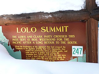
Lolo Pass, elevation 5,233 feet (1,595 m), is a mountain pass in the western United States, in the Bitterroot Range of the northern Rocky Mountains. It is on the border between the states of Montana and Idaho, approximately 40 miles (65 km) west-southwest of Missoula, Montana.

North Central Idaho is an area which spans the central part of the state of Idaho and borders Oregon, Montana, and Washington. It is the southern half of the Idaho Panhandle region and is rich in agriculture and natural resources. Lewis and Clark travelled through this area on their journey to the Pacific Ocean in 1805-06. The primary cities in this region are Lewiston and Moscow, home of the University of Idaho.
The Selway–Bitterroot Wilderness is a protected wilderness area in the states of Idaho and Montana, in the northwestern United States.

Clearwater National Forest with headquarters on the Nez Perce Reservation at Kamiah is located in North Central Idaho in the northwestern United States. The forest is bounded on the east by the state of Montana, on the north by the Idaho Panhandle National Forest, and on the south and west by the Nez Perce National Forest and Palouse Prairie.

Bitterroot National Forest comprises 1.587 million acres (6,423 km²) in west-central Montana and eastern Idaho, of the United States. It is located primarily in Ravalli County, Montana, but also has acreage in Idaho County, Idaho (29.24%), and Missoula County, Montana (0.49%).

Bruneau is an unincorporated community in Owyhee County in the southwestern part of the U.S. state of Idaho. The mouth of the Bruneau River is to the northwest and Bruneau Sand Dunes State Park is to the east. As of 2014, Bruneau has a population of 552.

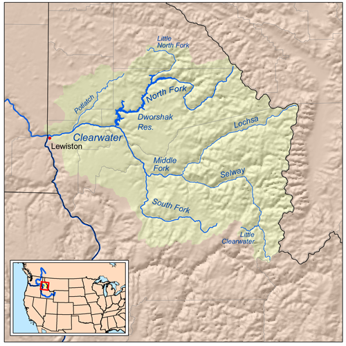
The Lochsa River is in the northwestern United States, in the mountains of north central Idaho. It is one of two primary tributaries of the Middle Fork of the Clearwater River in the Clearwater National Forest. Lochsa is a Nez Perce word meaning rough water. The Salish name is Ep Smɫí, "It Has Salmon."

The Selway River is a large tributary of the Middle Fork of the Clearwater River in the U.S. state of Idaho. It flows within the Selway-Bitterroot Wilderness, the Bitterroot National Forest, and the Nez Perce National Forest of North Central Idaho. The entire length of the Selway was included by the United States Congress in 1968 as part of the National Wild and Scenic Rivers Act.
Atlanta is an unincorporated community in Elmore County, Idaho, United States.
U.S. Route 12 is a federal highway in north central Idaho. It extends 174.210 miles (280.364 km) from the Washington state line in Lewiston east to the Montana state line at Lolo Pass, generally along the route of the Lewis and Clark expedition, and is known as the Northwest Passage Scenic Byway It was previously known as the Lewis and Clark Highway.

The Clearwater River is in the northwestern United States, in north central Idaho. Its length is 74.8 miles (120.4 km), it flows westward from the Bitterroot Mountains along the Idaho-Montana border, and joins the Snake River at Lewiston. In October 1805, the Lewis and Clark Expedition descended the Clearwater River in dugout canoes, putting in at "Canoe Camp," five miles (8 km) downstream from Orofino; they reached the Columbia Bar and the Pacific Ocean about six weeks later.

The Middle Fork Clearwater River is a short, but high volume river in northern Idaho and is the major source of the Clearwater River, a tributary of the Snake River. The Middle Fork flows west for 23 miles (37 km) from the confluence of the Selway River and Lochsa River at Lowell, to the town of Kooskia where it joins with the South Fork Clearwater River to create the Clearwater River. The Middle Fork's entire length is within Idaho County, although a small portion of its watershed extends into Clearwater County.

The Idaho Batholith ecoregion is a Level III ecoregion designated by the United States Environmental Protection Agency (EPA) in the U.S. states of Idaho and Montana. It is contained within the following biomes designated by the World Wild Fund for Nature (WWF): Temperate coniferous forests; Temperate grasslands, savannas, and shrublands; and Deserts and xeric shrublands.
Syringa is an unincorporated town in Idaho County, Idaho, United States. The town is named for the shrub which grows in the area [Philadelphus lewisii], and is the Idaho State Flower. It is in the Pacific Time Zone,. The climate is mild with an average precipitation of over 25 inches per year.
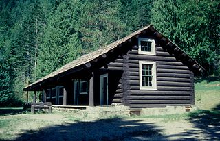
The Lochsa Historical Ranger Station, also known as Lochsa Ranger Station, near Kooskia, Idaho in Idaho County, Idaho, was built during 1927 to 1933. It served as administrative headquarters for the Lochsa Ranger District from 1922 to 1957. It was located within the Selway National Forest which was later merged into the Clearwater National Forest and the Nezperce National Forest. It was listed on the National Register of Historic Places in 1978.