Cottonwood, Idaho

Last updated

Cottonwood, Idaho
Lunch in Cottonwood, Idaho (5947364833).jpg
Idaho County Idaho Incorporated and Unincorporated areas Cottonwood Highlighted 1618640.svg
Location of Cottonwood in Idaho County, Idaho.
Coordinates: 46°3′8″N116°21′2″W / 46.05222°N 116.35056°W / 46.05222; -116.35056
Country United States
State Idaho
County Idaho
Area
[1]
  Total0.84 sq mi (2.17 km2)
  Land0.84 sq mi (2.17 km2)
  Water0.00 sq mi (0.00 km2)
Elevation
3,497 ft (1,066 m)
Population
 (2010) [2]
  Total900
  Estimate 
(2019) [3]
940
  Density1,120.38/sq mi (432.45/km2)
Time zone UTC-8 (Pacific (PST))
  Summer (DST) UTC-7 (PDT)
ZIP codes
83522
Area code 208
FIPS code 16-18640
GNIS feature ID0372152

Cottonwood is a city in Idaho County, Idaho. On the Camas Prairie in north central Idaho, the population was 822 at the 2020 census, [4] down from 900 in 2010 and 944 in 2000. It is just west of U.S. Route 95, between Grangeville and Lewiston.

Contents

Origins

Cottonwood began in 1862 as a series of way station shelters for prospectors and mining suppliers on their way south to Florence and Warrens. It was named for the dense growth of trees that formerly lined Cottonwood Creek. [5]

Demographics

Historical population
CensusPop.Note
1910 555
1920 6109.9%
1930 519−14.9%
1940 67329.7%
1950 6892.4%
1960 1,08156.9%
1970 867−19.8%
1980 9418.5%
1990 822−12.6%
2000 94414.8%
2010 900−4.7%
2019 (est.)940 [3] 4.4%
U.S. Decennial Census [6]

2010 census

As of the census [2] of 2010, there were 900 people, 363 households, and 240 families residing in the city. The population density was 1,071.4 inhabitants per square mile (413.7/km2). There were 392 housing units at an average density of 466.7 per square mile (180.2/km2). The racial makeup of the city was 97.1% White, 0.9% African American, 0.3% Native American, 0.2% Asian, 0.1% Pacific Islander, 0.4% from other races, and 0.9% from two or more races. Hispanic or Latino of any race were 0.9% of the population.

There were 363 households, of which 31.4% had children under the age of 18 living with them, 52.9% were married couples living together, 10.5% had a female householder with no husband present, 2.8% had a male householder with no wife present, and 33.9% were non-families. 28.7% of all households were made up of individuals, and 17.1% had someone living alone who was 65 years of age or older. The average household size was 2.43 and the average family size was 3.05.

The median age in the city was 43.2 years. 26.6% of residents were under the age of 18; 7.3% were between the ages of 18 and 24; 18.6% were from 25 to 44; 29% were from 45 to 64; and 18.4% were 65 years of age or older. The gender makeup of the city was 48.1% male and 51.9% female.

2000 census

As of the census [7] of 2000, there were 944 people, 364 households, and 242 families residing in the city. The population density was 1,136.4 inhabitants per square mile (438.8/km2). There were 398 housing units at an average density of 479.1 per square mile (185.0/km2). The racial makeup of the city was 97.99% White, 0.64% Native American, 0.42% Asian, and 0.95% from two or more races. Hispanic or Latino of any race were 0.42% of the population.

There were 364 households, out of which 34.6% had children under the age of 18 living with them, 54.7% were married couples living together, 8.2% had a female householder with no husband present, and 33.5% were non-families. 28.8% of all households were made up of individuals, and 15.4% had someone living alone who was 65 years of age or older. The average household size was 2.51 and the average family size was 3.14.

In the city, the population was spread out, with 29.7% under the age of 18, 6.3% from 18 to 24, 24.6% from 25 to 44, 21.5% from 45 to 64, and 18.0% who were 65 years of age or older. The median age was 39 years. For every 100 females, there were 94.2 males. For every 100 females age 18 and over, there were 94.2 males.

The median income for a household in the city was $34,167, and the median income for a family was $39,625. Males had a median income of $30,833 versus $20,833 for females. The per capita income for the city was $15,003. About 5.8% of families and 10.7% of the population were below the poverty line, including 6.7% of those under age 18 and 6.2% of those age 65 or over.

Geography

The Dog Bark Park Inn, a dog-shaped hotel room in Cottonwood Dog Bark Park, Cottonwood, Idaho.jpg
The Dog Bark Park Inn, a dog-shaped hotel room in Cottonwood

Cottonwood is located at 46°3′8″N116°21′2″W / 46.05222°N 116.35056°W / 46.05222; -116.35056 (46.0522, -116.3506). [8] at an elevation of 3,500 feet (1,070 m) above sea level.

According to the United States Census Bureau, the city has a total area of 0.84 square miles (2.18 km2), all of it land. [9]

Cottonwood is home to the Dog Bark Park Inn, a hotel in the shape of a beagle.

Climate

The climate in this area has mild differences between highs and lows, and there is adequate rainfall year-round. According to the Köppen Climate Classification system, Cottonwood has a marine west coast climate, abbreviated "Cfb" on climate maps. [10]

Climate data for Cottonwood, Idaho (1991–2020 normals, extremes 1976–present)
MonthJanFebMarAprMayJunJulAugSepOctNovDecYear
Record high °F (°C)60
(16)
64
(18)
72
(22)
83
(28)
86
(30)
100
(38)
100
(38)
103
(39)
96
(36)
87
(31)
68
(20)
59
(15)
103
(39)
Mean daily maximum °F (°C)37.1
(2.8)
40.2
(4.6)
47.6
(8.7)
53.9
(12.2)
63.0
(17.2)
69.4
(20.8)
80.6
(27.0)
81.4
(27.4)
72.2
(22.3)
57.4
(14.1)
43.6
(6.4)
35.8
(2.1)
56.9
(13.8)
Daily mean °F (°C)30.9
(−0.6)
33.3
(0.7)
39.0
(3.9)
44.5
(6.9)
52.6
(11.4)
58.7
(14.8)
68.3
(20.2)
68.6
(20.3)
60.4
(15.8)
48.0
(8.9)
36.8
(2.7)
29.7
(−1.3)
47.6
(8.7)
Mean daily minimum °F (°C)24.7
(−4.1)
26.3
(−3.2)
30.5
(−0.8)
35.1
(1.7)
42.2
(5.7)
48.1
(8.9)
56.1
(13.4)
55.9
(13.3)
48.7
(9.3)
38.7
(3.7)
29.9
(−1.2)
23.6
(−4.7)
38.3
(3.5)
Record low °F (°C)−11
(−24)
−20
(−29)
4
(−16)
18
(−8)
24
(−4)
32
(0)
31
(−1)
32
(0)
25
(−4)
8
(−13)
−5
(−21)
−18
(−28)
−20
(−29)
Average precipitation inches (mm)1.81
(46)
1.64
(42)
2.12
(54)
2.67
(68)
2.78
(71)
2.64
(67)
1.16
(29)
0.84
(21)
1.06
(27)
1.77
(45)
2.20
(56)
1.93
(49)
22.62
(575)
Average snowfall inches (cm)16.3
(41)
11.0
(28)
8.7
(22)
1.8
(4.6)
0.3
(0.76)
0.0
(0.0)
0.0
(0.0)
0.0
(0.0)
0.1
(0.25)
0.4
(1.0)
6.3
(16)
16.5
(42)
61.4
(156)
Average precipitation days (≥ 0.01 in)12.610.913.014.814.812.25.55.26.111.012.912.7131.7
Average snowy days (≥ 0.1 in)8.05.44.61.40.20.00.00.00.00.43.49.532.9
Source: NOAA [11] [12]

Transportation

Highways

The city is just west of U.S. Route 95, the state's main north-south highway, which formerly went through central Cottonwood. It was re-routed in 1976 with the completion of the new bypass, east of the city. [13]

Railroad

The city is the southern terminus of the BG&CM Railroad, a freight line with a northern terminus at Spalding. It runs on the former tracks of the Camas Prairie Railroad, whose second subdivision line continued to Fenn and Grangeville. The last run to Fenn and Grangeville was on November 29, 2000, [14] [15] and those tracks were removed by mid-2003. [16] [17]

Education

The Cottonwood Joint School District #242 operates the public schools, led by Prairie Junior/Senior High School in Cottonwood. [18] St. John Bosco, a Catholic K-12 School, provides a classical Catholic Education.

Notable people

See also

Related Research Articles

<span class="mw-page-title-main">Lewiston, Idaho</span> City in Idaho, United States

Lewiston is a city and the county seat of Nez Perce County, Idaho, United States, in the state's north central region. It is the third-largest city in the northern Idaho region, behind Post Falls and Coeur d'Alene, and the twelfth-largest in the state. Lewiston is the principal city of the Lewiston, ID-WA Metropolitan Statistical Area, which includes all of Nez Perce County and Asotin County, Washington. As of the 2020 census, the population of Lewiston was 34,203, up from 31,894 in 2010.

<span class="mw-page-title-main">Lewis County, Idaho</span> County in Idaho, United States

Lewis County is a county located in the north central region of the U.S. state of Idaho. As of the 2020 census, the population was 3,533, making it the fourth-least populous county in Idaho. The county seat is Nezperce, and Kamiah is the largest city. Partitioned from Nez Perce County and established in 1911, it was named after the explorer Meriwether Lewis. Most of the county is within the Nez Perce Indian Reservation, though Native Americans comprise less than 6% of the county population. Similar to the opening of lands in Oklahoma, the U.S. government opened the reservation for white settlement in November 1895. The proclamation had been signed less than two weeks earlier by President Cleveland.

<span class="mw-page-title-main">Idaho County, Idaho</span> County in Idaho, United States

Idaho County is a county in the U.S. state of Idaho, and the largest by area in the state. As of the 2020 census, the population was 16,541. The county seat is Grangeville. Previous county seats of the area were Florence (1864–68), Washington (1868–75), and Mount Idaho (1875–1902).

<span class="mw-page-title-main">Clark County, Idaho</span> County in Idaho, United States

Clark County is a rural county in the U.S. state of Idaho; its county seat and largest city is Dubois. As of the 2020 census, the population was 790, making it the least populous county in the state.

<span class="mw-page-title-main">Camas County, Idaho</span> County in Idaho, United States

Camas County is a county in the southern portion of the U.S. state of Idaho. The county seat and largest city is Fairfield. The county was established 107 years ago in 1917 by the Idaho Legislature with a partition of Blaine County on February 6. It is named for the camas root, or Camassia, a lily-like plant with an edible bulb found in the region, that Native Americans and settlers used as a food source. As of the 2020 census, the population was 1,077, making it the second-least populous county in the state, after Clark County.

<span class="mw-page-title-main">Horseshoe Bend, Idaho</span> City in Idaho, United States

Horseshoe Bend is the largest city in rural Boise County, in the southwestern part of the U.S. state of Idaho. Its population of 707 at the 2010 census was the largest in the county, though down from 770 in 2000.

<span class="mw-page-title-main">Dubois, Idaho</span> City in Idaho, United States

Dubois is a city in Clark County, Idaho, United States. The population was 511 at the 2020 census. The city is the county seat of Clark County.

<span class="mw-page-title-main">Orofino, Idaho</span> City in Idaho, United States

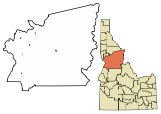
Orofino is a city in and the county seat of Clearwater County, Idaho, United States, along Orofino Creek and the north bank of the Clearwater River. It is the major city within the Nez Perce Indian Reservation. The population was 3,142 at the time of the 2010 census.

<span class="mw-page-title-main">Ferdinand, Idaho</span> City in Idaho, United States

Ferdinand is a city in Idaho County, Idaho, United States. The population was 159 at the 2010 census, up from 145 in 2000. At the southern end of the Nez Perce Indian Reservation, it was founded by F.M. Bieker shortly after the reservation was opened for settlement in 1895. It was named after Ferdinand, Indiana, where his mother's family had lived.

<span class="mw-page-title-main">Grangeville, Idaho</span> City in Idaho, United States

Grangeville is the largest city in and the county seat of Idaho County, Idaho, United States, in the north central part of the state. Its population was 3,141 at the 2010 census, down from 3,228 in 2000.

<span class="mw-page-title-main">Kamiah, Idaho</span> City in Idaho, United States

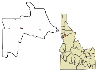
Kamiah is a city in Lewis and Idaho counties in the U.S. state of Idaho. The largest city in Lewis County, it extends only a small distance into Idaho County, south of Lawyer Creek. The population was 1,295 at the 2010 census, up from 1,160 in 2000. The city lies in the narrow valley of the Clearwater River; downstream are Orofino and Lewiston, at the confluence with the Snake River.

<span class="mw-page-title-main">Kooskia, Idaho</span> City in Idaho, United States

Kooskia is a city in Idaho County, Idaho, United States. It is at the confluence of the South and Middle forks of the Clearwater River, combining to become the main river. The population was 607 at the 2010 census, down from 675 in 2000.

<span class="mw-page-title-main">Riggins, Idaho</span> City in Idaho, United States

Riggins is a city in the western United States in Idaho County, Idaho. Nestled deep in a canyon at the confluence of the Salmon and Little Salmon rivers in west central Idaho, it is approximately 150 highway miles (240 km) north of Boise, and 120 highway miles (190 km) south-southeast of Lewiston. The elevation is 1,821 feet (555 m) above sea level, and its population was 419 at the 2010 census.

<span class="mw-page-title-main">Stites, Idaho</span> City in Idaho, United States

Stites is a city in Idaho County, Idaho, United States. In the lower canyon of the South Fork of the Clearwater River, it is about four miles (6 km) upstream and south of Kooskia on State Highway 13. The population was 221 at the 2010 census, down from 226 in 2000.

<span class="mw-page-title-main">White Bird, Idaho</span> Town in Idaho, United States

White Bird is a city in Idaho County, Idaho. The population was 91 at the time of the 2010 census, down from 106 in 2000.

<span class="mw-page-title-main">Craigmont, Idaho</span> City in Idaho, United States

Craigmont is a city in the northwest United States in Lewis County, Idaho. Located on the Camas Prairie in north central Idaho, it is within the Nez Perce Indian Reservation. The population was 501 at the 2010 census, down from 556 in 2000.

<span class="mw-page-title-main">Nezperce, Idaho</span> City in Idaho, United States

Nezperce is a city in and the county seat of Lewis County, Idaho, United States. The population was 466 at the 2010 census, down from 523 in 2000. Nezperce is named for the local Nez Perce tribe of Native Americans. There is one school district, Nezperce School District #302.

<span class="mw-page-title-main">Winchester, Idaho</span> City in Idaho, United States

Winchester is a city in western Lewis County, Idaho, United States, located on the Camas Prairie in the north central part of the state. The population was 356 at the 2020 census, up from 340 in 2010.

<span class="mw-page-title-main">Lapwai, Idaho</span> City in Idaho, United States

Lapwai is a city in Nez Perce County, Idaho, United States. Its population was 1,137 at the 2010 census, and it is the seat of government of the Nez Perce Indian Reservation.

<span class="mw-page-title-main">Lewiston, Utah</span> City in Utah, United States

Lewiston is a city in Cache County, Utah, United States. It is situated at the northern Utah border and borders the state of Idaho. The population was 1,766 at the 2010 census. It is included in the Logan, Utah-Idaho (partial) Metropolitan Statistical Area.

References

  1. "2019 U.S. Gazetteer Files". United States Census Bureau. Retrieved July 9, 2020.
  2. 1 2 "U.S. Census website". United States Census Bureau . Retrieved December 18, 2012.
  3. 1 2 "Population and Housing Unit Estimates". United States Census Bureau. May 24, 2020. Retrieved May 27, 2020.
  4. "Explore Census Data". data.census.gov. Retrieved April 30, 2024.
  5. "Cottonwood, once a miner's stop, is now a farming, cattle center". Lewiston Morning Tribune. October 6, 1955. p. 8.
  6. "Census of Population and Housing". Census.gov. Retrieved June 4, 2015.
  7. "U.S. Census website". United States Census Bureau . Retrieved January 31, 2008.
  8. "US Gazetteer files: 2010, 2000, and 1990". United States Census Bureau. February 12, 2011. Retrieved April 23, 2011.
  9. "US Gazetteer files 2010". United States Census Bureau. Archived from the original on July 2, 2012. Retrieved December 18, 2012.
  10. Climate Summary for Cottonwood, Idaho
  11. "NOWData - NOAA Online Weather Data". National Oceanic and Atmospheric Administration. Retrieved December 13, 2023.
  12. "Summary of Monthly Normals 1991-2020". National Oceanic and Atmospheric Administration. Retrieved December 13, 2023.
  13. "Cottonwood bypass open to U.S. traffic". Lewiston Morning Tribune. July 13, 1976. p. 7A.
  14. "Camas Prairie dream out of steam". Moscow-Pullman Daily News. Associated Press. November 30, 2000. p. 2A.
  15. Walker, Jodi (December 31, 2000). "Some cracks in the foundation: Last train to Grangeville". Lewiston Morning Tribune. p. 3A.
  16. Williams, Elaine (February 17, 2004). "Railroad changing hands". Lewiston Morning Tribune. p. 1A.
  17. Williams, Elaine (March 4, 2004). "Railroad changes hands, trains keep on running". Lewiston Morning Tribune. p. 6A.
  18. "Prairie Junior/Senior High School". Cottonwood Joint School District #242. Archived from the original on May 3, 2009. Retrieved November 28, 2012.