Idaho is a state in the Pacific Northwest region of the United States. To the north, it shares a small portion of the Canada–United States border with the province of British Columbia. It borders the states of Montana and Wyoming to the east, Nevada and Utah to the south, and Washington and Oregon to the west. The state's capital and largest city is Boise. With an area of 83,570 square miles (216,400 km2), Idaho is the 14th largest state by land area, but with a population of approximately 1.8 million, it ranks as the 13th least populous and the 6th least densely populated of the 50 U.S. states.

The Nez Perce are an Indigenous people of the Plateau who still live on a fraction of the lands on the southeastern Columbia River Plateau in the Pacific Northwest. This region has been occupied for at least 11,500 years.

The Snake River is a major river of the greater Pacific Northwest region in the United States. At 1,078 miles (1,735 km) long, it is the largest tributary of the Columbia River, in turn, the largest North American river that empties into the Pacific Ocean. The Snake River rises in western Wyoming, then flows through the Snake River Plain of southern Idaho, the rugged Hells Canyon on the Oregon–Idaho border and the rolling Palouse Hills of Washington, emptying into the Columbia River at the Tri-Cities in the Columbia Basin of Eastern Washington.

Lewiston is a city and the county seat of Nez Perce County, Idaho, United States, in the state's north central region. It is the third-largest city in the northern Idaho region, behind Post Falls and Coeur d'Alene, and the twelfth-largest in the state. Lewiston is the principal city of the Lewiston, ID-WA Metropolitan Statistical Area, which includes all of Nez Perce County and Asotin County, Washington. As of the 2020 census, the population of Lewiston was 34,203, up from 31,894 in 2010.

Nez Perce County is a county located in the U.S. state of Idaho. As of the 2020 census, the population was 42,090. The county seat is Lewiston. The county is named after the Native American Nez Percé tribe. Nez Perce County is part of the Lewiston, Idaho–WA Metropolitan Statistical Area.

Lewis County is a county located in the north central region of the U.S. state of Idaho. As of the 2020 census, the population was 3,533, making it the fourth-least populous county in Idaho. The county seat is Nezperce, and Kamiah is the largest city. Partitioned from Nez Perce County and established in 1911, it was named after the explorer Meriwether Lewis. Most of the county is within the Nez Perce Indian Reservation, though Native Americans comprise less than 6% of the county population. Similar to the opening of lands in Oklahoma, the U.S. government opened the reservation for white settlement in November 1895. The proclamation had been signed less than two weeks earlier by President Cleveland.

Idaho County is a county in the U.S. state of Idaho, and the largest by area in the state. As of the 2020 census, the population was 16,541. The county seat is Grangeville. Previous county seats of the area were Florence (1864–68), Washington (1868–75), and Mount Idaho (1875–1902).

Clearwater County is a county located in the U.S. state of Idaho. As of the 2020 census, the population was 8,734. The county seat is Orofino. Established in 1911, the county was named after the Clearwater River.

The Salmon River, also known as "The River of No Return", is a river located in the U.S. state of Idaho in the western United States. It flows for 425 miles (685 km) through central Idaho, draining a rugged, thinly populated watershed of 14,000 square miles (36,000 km2). The river drops more than 7,000 feet (2,100 m) from its headwaters, near Galena Summit above the Sawtooth Valley in the Sawtooth National Recreation Area, to its confluence with the Snake River. Measured at White Bird, its average discharge is 11,060 cubic feet per second. The Salmon River is the longest undammed river in the contiguous United States

The Nez Perce National Historical Park is a United States National Historical Park comprising 38 sites located across the states of Idaho, Montana, Oregon, and Washington, which include traditional aboriginal lands of the Nez Perce people. The sites are strongly associated with the resistance of Chief Joseph and his band, who in June 1877 migrated from Oregon in an attempt to reach freedom in Canada and avoid being forced on to a reservation. They were pursued by U.S. Army cavalry forces and fought numerous skirmishes against them during the so-called Nez Perce War, which eventually ended with Chief Joseph's surrender in the Montana Territory.
Dworshak National Fish Hatchery is a mitigation hatchery located on the Clearwater River within the Nez Perce Reservation near Ahsahka, in north-central Idaho, United States. It was constructed in 1969 by the Army Corps of Engineers, and is co-managed by the U.S. Fish and Wildlife Service and the Nez Perce Tribe. The hatchery is one of the largest combination producers of anadromous (migratory) fish in the world. These fish make a 1000-mile round trip to the ocean and back to spawn in the Clearwater River. The Dworshak Dam blocks access to the historical spawning areas on the North Fork-Clearwater River for the steelhead, and it is too high for a fish ladder.

Clearwater National Forest with headquarters on the Nez Perce Reservation at Kamiah is located in North Central Idaho in the northwestern United States. The forest is bounded on the east by the state of Montana, on the north by the Idaho Panhandle National Forest, and on the south and west by the Nez Perce National Forest and Palouse Prairie.
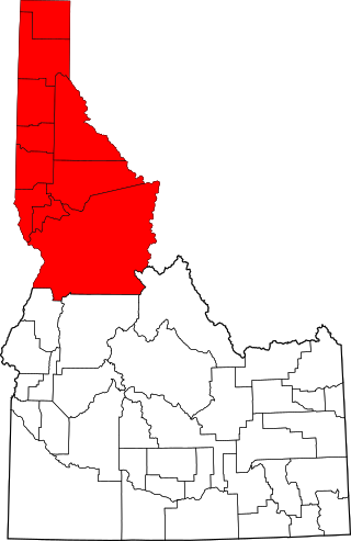
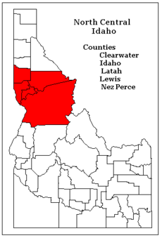
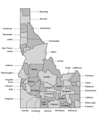
The Idaho Panhandle—locally known as North Idaho—is a salient region of the U.S. state of Idaho encompassing the state's 10 northernmost counties: Benewah, Bonner, Boundary, Clearwater, Idaho, Kootenai, Latah, Lewis, Nez Perce, and Shoshone. The Panhandle is bordered by the state of Washington to the west, Montana to the east, and the Canadian province of British Columbia to the north. The Idaho panhandle, along with Eastern Washington, makes up the region known as the Inland Northwest, headed by its largest city, Spokane, Washington.

Dworshak Dam is a concrete gravity dam in the western United States, on the North Fork of the Clearwater River in north central Idaho. In Clearwater County, the dam is located approximately four miles (6 km) northwest of Orofino and impounds the Dworshak Reservoir for flood control and hydroelectricity generation.

The Selway River is a large tributary of the Middle Fork of the Clearwater River in the U.S. state of Idaho. It flows within the Selway-Bitterroot Wilderness, the Bitterroot National Forest, and the Nez Perce National Forest of North Central Idaho. The entire length of the Selway was included by the United States Congress in 1968 as part of the National Wild and Scenic Rivers Act.
The U.S. state of Idaho borders six other U.S. states and one Canadian province. The states of Washington and Oregon are to the west, Nevada and Utah are to the south, and Montana and Wyoming are to the east. Idaho also shares a short border with the Canadian province of British Columbia to the north.

Idaho State Highway 11 (SH-11) is a state highway in north central Idaho. It runs 42.481 miles (68.37 km) from U.S. Route 12 near Greer, north to Forest Service Roads 246 and 247 near Headquarters.

U.S. Route 12 (US-12) is a United States Numbered Highway in North Central Idaho. It extends 174.410 miles (280.686 km) from the Washington state line in Lewiston east to the Montana state line at Lolo Pass, generally along the route of the Lewis and Clark Expedition, and is known as the Northwest Passage Scenic Byway. It was previously known as the Lewis and Clark Highway.

The Clearwater River is in the northwestern United States, in north central Idaho. Its length is 74.8 miles (120.4 km), it flows westward from the Bitterroot Mountains along the Idaho-Montana border, and joins the Snake River at Lewiston. In October 1805, the Lewis and Clark Expedition descended the Clearwater River in dugout canoes, putting in at "Canoe Camp," five miles (8 km) downstream from Orofino; they reached the Columbia Bar and the Pacific Ocean about six weeks later.
Syringa is an unincorporated community in the northwest United States in Idaho County, Idaho. Named for the shrub which grows in the area [Philadelphus lewisii], the state flower, it is in the Pacific Time Zone (UTC-8). At low elevation, the climate is mild, with an average annual precipitation exceeding 25 inches (65 cm).