Chubbuck, Idaho

Last updated

Chubbuck, Idaho
Chubbuck, Idaho entrance.jpg
Chubbuck, Idaho entrance, off I-86.
Bannock County Idaho Incorporated and Unincorporated areas Chubbuck Highlighted 1614680.svg
Location of Chubbuck in Bannock County, Idaho.
Usa edcp location map.svg
Red pog.svg
Chubbuck, Idaho
Location in the United States
Coordinates: 42°55′18″N112°28′3″W / 42.92167°N 112.46750°W / 42.92167; -112.46750
CountryUnited States
State Idaho
County Bannock
Government
  MayorKevin B. England
Area
[1]
  Total5.91 sq mi (15.30 km2)
  Land5.90 sq mi (15.28 km2)
  Water0.01 sq mi (0.03 km2)
Elevation
4,472 ft (1,363 m)
Population
 (2010) [2]
  Total13,922
  Estimate 
(2019) [3]
15,588
  Density2,642.48/sq mi (1,020.21/km2)
Time zone UTC−7 (Mountain (MST))
  Summer (DST) UTC−6 (MDT)
ZIP code
83202
Area code(s) 208, 986
FIPS code 16-14680
GNIS feature ID0396285
Interstate I-86.svg
U.S. Route US 91.svg
Website www.cityofchubbuck.us

Chubbuck is a city in Bannock County, Idaho. It is part of the Pocatello Metropolitan Statistical Area. The population was 13,922 at the 2010 census. Chubbuck is located immediately north of Pocatello, Idaho, and has opposed several consolidation proposals since the 1960s.

Contents

Geography

Chubbuck is located at 42°55′18″N112°28′3″W / 42.92167°N 112.46750°W / 42.92167; -112.46750 (42.921648, -112.467416), [4] at an elevation of 4,472 feet (1,363 m) above sea level.

According to the United States Census Bureau, the city has a total area of 4.20 square miles (10.88 km2), of which, 4.19 square miles (10.85 km2) is land and 0.01 square miles (0.03 km2) is water. [5]

The area's main shopping mall is Pine Ridge Mall.

Government

The mayor of Chubbuck is Kevin B. England. [6]

Demographics

Historical population
CensusPop.Note
1950 120
1960 1,5901,225.0%
1970 2,92483.9%
1980 7,052141.2%
1990 7,79110.5%
2000 9,70024.5%
2010 13,92243.5%
2019 (est.)15,588 [3] 12.0%
U.S. Decennial Census [7]

2010 census

As of the census [2] of 2010, there were 13,922 people, 4,732 households, and 3,586 families living in the city. The population density was 3,322.7 inhabitants per square mile (1,282.9/km2). There were 4,961 housing units at an average density of 1,184.0 per square mile (457.1/km2). The racial makeup of the city was 90.5% White, 0.4% African American, 2.4% Native American, 1.1% Asian, 0.3% Pacific Islander, 2.3% from other races, and 3.0% from two or more races. Hispanic or Latino of any race were 7.5% of the population.

There were 4,732 households, of which 44.7% had children under the age of 18 living with them, 60.0% were married couples living together, 11.0% had a female householder with no husband present, 4.8% had a male householder with no wife present, and 24.2% were non-families. 19.9% of all households were made up of individuals, and 8.3% had someone living alone who was 65 years of age or older. The average household size was 2.94 and the average family size was 3.40.

The median age in the city was 30.2 years. 33.5% of residents were under the age of 18; 8.4% were between the ages of 18 and 24; 27.9% were from 25 to 44; 20.3% were from 45 to 64; and 10% were 65 years of age or older. The gender makeup of the city was 48.6% male and 51.4% female.

2000 census

As of the census [8] of 2000, there were 9,700 people, 3,190 households, and 2,491 families living in the city. The population density was 2,743.5 inhabitants per square mile (1,059.3/km2). There were 3,377 housing units at an average density of 955.1 per square mile (368.8/km2). The racial makeup of the city was 91.80% White, 0.35% African American, 2.00% Native American, 1.09% Asian, 0.04% Pacific Islander, 2.47% from other races, and 2.24% from two or more races. Hispanic or Latino of any race were 5.38% of the population.

There were 3,190 households, out of which 45.4% had children under the age of 18 living with them, 63.4% were married couples living together, 10.7% had a female householder with no husband present, and 21.9% were non-families. 18.4% of all households were made up of individuals, and 7.2% had someone living alone who was 65 years of age or older. The average household size was 3.02 and the average family size was 3.46.

In the city, the population was spread out, with 33.9% under the age of 18, 10.5% from 18 to 24, 27.6% from 25 to 44, 19.3% from 45 to 64, and 8.7% who were 65 years of age or older. The median age was 29 years. For every 100 females, there were 97.6 males. For every 100 females age 18 and over, there were 93.4 males.

The median income for a household in the city was $41,688, and the median income for a family was $48,138. Males had a median income of $40,726 versus $25,230 for females. The per capita income for the city was $15,936. About 9.1% of families and 12.0% of the population were below the poverty line, including 15.1% of those under age 18 and 6.6% of those age 65 or over.

Education

Chubbuck is a part of the Pocatello/Chubbuck School District. It has two elementary schools within the city limits. [9] Zoned elementary schools serving Chubbuck include Chubbuck Elementary School, Rulon M. Ellis Elementary School, Syringa Elementary School in Pocatello, Wilcox Elementary School in Pocatello, and Tyhee Elementary School in Tyhee. [10]

Residents are zoned to Hawthorne Middle School in Pocatello, Alameda Middle School in Pocatello, Irving Middle School in Pocatello, and a small portion of residents to the east of Interstate 15 are zoned to Franklin Middle School in Pocatello. [11] Residents are zoned to Pocatello High School and Highland High School both in Pocatello. [12]

See also

Related Research Articles

<span class="mw-page-title-main">Bannock County, Idaho</span> County in Idaho, United States

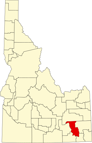
Bannock County is a county in the southeastern part of Idaho. As of the 2020 Census, the population was 87,018, making it the sixth-most populous county in Idaho. The county seat and largest city is Pocatello. The county was established in 1893 and named after the local Bannock tribe. It is one of the counties with territories included in the Fort Hall Indian Reservation of the federally recognized Shoshone-Bannock Tribes.

<span class="mw-page-title-main">Eagle, Idaho</span> City in Idaho, United States

Eagle is a city in the western United States in Ada County, Idaho, ten miles (16 km) northwest of downtown Boise. The population was 30,346 at the time of the 2020 census.

<span class="mw-page-title-main">Arimo, Idaho</span> City in Bannock County, Idaho, United States

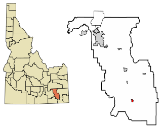
Arimo is a city in the Marsh Valley in central Bannock County, Idaho, United States, that is part of the 'Pocatello Metropolitan Statistical Area'. The population was 354 at the 2020 census.

<span class="mw-page-title-main">Downey, Idaho</span> City in Bannock County, Idaho, United States

Downey is a city in the Marsh Valley in southern Bannock County, Idaho, United States. It is part of the Pocatello Metropolitan Statistical Area. The population was 625 at the 2010 census.

<span class="mw-page-title-main">McCammon, Idaho</span> City in Idaho, United States

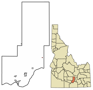
McCammon is a city in Bannock County, Idaho, United States. It is part of the Pocatello, Idaho Metropolitan Statistical Area'. The population was 809 at the 2010 census. In 1892, McCammon became the junction point between the Oregon Short Line Railroad and Utah and Northern Railway, and city gained the nickname Junction City.

<span class="mw-page-title-main">Pocatello, Idaho</span> City in the United States

Pocatello is the county seat and largest city of Bannock County, with a small portion on the Fort Hall Indian Reservation in neighboring Power County, in the southeastern part of the U.S. state of Idaho. It is the principal city of the Pocatello metropolitan area, which encompasses all of Bannock County. As of the 2020 census, the population of Pocatello was 56,326.

<span class="mw-page-title-main">Aberdeen, Idaho</span> City in Bingham County, Idaho, United States

Aberdeen is a city in Bingham County, Idaho, United States. The community was named after Aberdeen, in Scotland. The population was 1,994 at the 2010 census, up from 1,840 in 2000.

<span class="mw-page-title-main">Albion, Idaho</span> City in Idaho, United States

Albion is a city in Cassia County, Idaho, United States. It is part of the Burley, Idaho Micropolitan Statistical Area. The population was 234 at the 2020 census. Albion was the county seat of Cassia County from 1879 to 1918.

<span class="mw-page-title-main">Malta, Idaho</span> City in Cassia County, Idaho, United States

Malta is a city in Cassia County, Idaho, United States. The population was 193 at the 2010 census. It is part of the Burley, Idaho Micropolitan Statistical Area.

<span class="mw-page-title-main">Rigby, Idaho</span> City in Idaho, United States

Rigby is a city in and the county seat of Jefferson County, Idaho, United States. The population was 5,038 at the 2020 census, up from 3,945 in 2010.

<span class="mw-page-title-main">Minidoka, Idaho</span> City in Idaho, United States

Minidoka is a city in Minidoka County, Idaho, United States. The population was 86 at the 2020 census, down from 112 in 2010. It is part of the Burley, Idaho Micropolitan Statistical Area.

<span class="mw-page-title-main">Pioneer Township, Michigan</span> Civil township in Michigan, United States

Pioneer Township is a civil township of Missaukee County in the U.S. state of Michigan. The population was 451 at the 2010 census.

<span class="mw-page-title-main">Fremont, Michigan</span> City in Michigan, United States

Fremont is a city in Newaygo County, Michigan, United States. The population was 4,516 at the time of the 2020 census.

<span class="mw-page-title-main">Crugers, New York</span> Hamlet and census-designated place in Cortlandt, New York

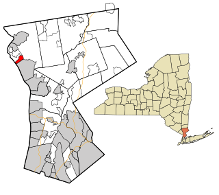
Crugers is a hamlet and census-designated place (CDP) located in the town of Cortlandt, Westchester County, New York, United States. The population was 1,534 at the 2010 census.

<span class="mw-page-title-main">Cherry Township, Butler County, Pennsylvania</span> Township in Pennsylvania, United States

Cherry Township is a township in Butler County, Pennsylvania, United States. The population was 1,106 at the 2010 census.

<span class="mw-page-title-main">Jourdanton, Texas</span> City in Texas, United States

Jourdanton is a city in and the county seat of Atascosa County, Texas, United States. The population is 4,094. It is part of the San Antonio metropolitan statistical area. The mayor is Robert "Doc" Williams. The city manager is Bobby J. Martinez. The police chief is Eric Kaiser. The fire chief is Jay Fojtik.

<span class="mw-page-title-main">Bridgeport, West Virginia</span> City in West Virginia, United States

Bridgeport is a city in eastern Harrison County, West Virginia, United States. The population was 9,325 at the 2020 census. It is part of the Clarksburg micropolitan area in North Central West Virginia. Bridgeport had its beginning in pre-American Revolutionary War times. In 1764, John Simpson entered the area and gave his name to Simpson Creek. Bridgeport was chartered in 1816.

<span class="mw-page-title-main">St. Albans, West Virginia</span> City in West Virginia, United States

St. Albans is a city in western Kanawha County, West Virginia, United States, at the confluence of the Kanawha and Coal rivers. The population was 10,861 at the 2020 census. It is part of the Charleston metropolitan area.

<span class="mw-page-title-main">Dekorra, Wisconsin</span> Town in Wisconsin, United States

Dekorra is a town in Columbia County, Wisconsin, United States. The population was 2,350 at the 2000 census.

<span class="mw-page-title-main">Sharonville, Ohio</span> City in Ohio, United States

Sharonville is a city largely in Hamilton county in the U.S. state of Ohio. The population was 14,117 at the 2020 census.

References

  1. "2019 U.S. Gazetteer Files". United States Census Bureau. Retrieved July 9, 2020.
  2. 1 2 "U.S. Census website". United States Census Bureau . Retrieved December 18, 2012.
  3. 1 2 "Population and Housing Unit Estimates". United States Census Bureau. May 24, 2020. Retrieved May 27, 2020.
  4. "US Gazetteer files: 2010, 2000, and 1990". United States Census Bureau. February 12, 2011. Retrieved April 23, 2011.
  5. "US Gazetteer files 2010". United States Census Bureau. Archived from the original on January 25, 2012. Retrieved December 18, 2012.
  6. "City of Chubbuck Website".
  7. "Census of Population and Housing". Census.gov. Retrieved June 4, 2015.
  8. "U.S. Census website". United States Census Bureau . Retrieved January 31, 2008.
  9. City of Chubbuck Archived 2010-01-26 at the Wayback Machine - schools
  10. "School District 25 Elementary School Boundaries Archived 2011-12-02 at the Wayback Machine ." Pocatello/Chubbuck School District. Retrieved on February 22, 2012.
  11. " Archived 2011-12-02 at the Wayback Machine ." Pocatello/Chubbuck School District. Retrieved on February 22, 2012.
  12. " Archived 2011-12-19 at the Wayback Machine ." Pocatello/Chubbuck School District. Retrieved on February 22, 2012.