Madison County, Idaho

Last updated

Madison County
Madison County Courthouse, Idaho.jpg
Madison County Courthouse
Madison County, Idaho seal.png
Map of Idaho highlighting Madison County.svg
Location within the U.S. state of Idaho
Idaho in United States.svg
Idaho's location within the U.S.
Coordinates: 43°47′N111°40′W / 43.79°N 111.66°W / 43.79; -111.66
CountryFlag of the United States.svg United States
StateFlag of Idaho.svg  Idaho
FoundedFebruary 18, 1913
Named for James Madison
Seat Rexburg
Largest cityRexburg
Area
  Total473 sq mi (1,230 km2)
  Land469 sq mi (1,210 km2)
  Water4.0 sq mi (10 km2)  0.8%
Population
 (2020)
  Total52,913 Increase2.svg
  Density110/sq mi (40/km2)
Time zone UTC−7 (Mountain)
  Summer (DST) UTC−6 (MDT)
Congressional district 2nd
Website www.co.madison.id.us

Madison County is a county located in the U.S. state of Idaho. As of the 2020 census, the population was 52,913. [1] The county seat and largest city is Rexburg. [2]

Contents

Madison County is part of the Rexburg, Idaho micropolitan area, which is also included in the Idaho Falls metropolitan area.

History

The area was originally settled by members of the Church of Jesus Christ of Latter-day Saints. Before February 1913, the county was part of neighboring Fremont County. The newly established county was named for American president James Madison. [3] Brigham Young University–Idaho, formerly Ricks College (named after early local LDS settler Thomas Edwin Ricks) is located in Madison County. Madison County was declared a national disaster area after the flood of June 5, 1976.

Madison County is the owner of the healthcare system in the region. However, it is contracted out to Madison Memorial. Madison Memorial began in 1951 when the doctors at that time decided it was time for the community to have a hospital. They then closed their practices and collaborated with the community to build Madison Memorial, a non-profit healthcare system. Since that time, Madison Memorial has continued to grow, promote population health for the region, and provide professional healthcare services for the region with over 800 employees. The region served includes the following counties Jefferson, Madison, Fremont, Teton, Clark, and Lemhi. Madison Memorial is the nearest hospital to Yellowstone National Park.

Government and politics

Similar to other Idaho counties, an elected three-member county commission heads the county government. Other elected officials include clerk, treasurer, sheriff, assessor, coroner, and prosecutor. [4]

With a strongly conservative population, Madison County is one of the most staunchly Republican counties in the United States. Since 1968 no Republican presidential candidate has failed to carry the county with less than 56 percent of the vote, and no Democratic presidential nominee has cracked 23 percent thereof. In that same period Republican presidential candidates polled more than 90 percent of the county's vote on three occasions, Ronald Reagan in 1984, [5] George W. Bush in 2004, [6] and Mitt Romney in 2012. [7] John McCain came close to this level in 2008, drawing 85 percent of the vote. [8] In 2016, Donald Trump won the county, but performed far worse in it than Republicans typically do: he received just 57 percent of the vote, [9] while Romney had received over 93 percent of the vote there just four years earlier. [7] However, this is attributed to the county also gave Evan McMullin almost thirty percent of the vote in 2016, which was his best performance of any county in the entire country that year. [10] [11]

In 2020, Trump won 79% of the vote, 22 points up from 2016. However this was still a lower vote share than those achieved by Republican candidates George W Bush in 2000 and 2004, John McCain in 2008 and Mitt Romney in 2012.

Joe Biden won 15.6%, up 7.9% from Hillary Clinton's vote share in 2016. Biden's vote share was the highest for a Democrat in a presidential race in this county since 1996. It was also one of just four times since Lyndon Johnson's 1964 landslide that a Democrat exceeded 15% (the others being the aforementioned 1996, as well as Jimmy Carter in 1976 and Hubert Humphrey in 1968).

At the state level Madison County is located in Legislative District 34, [12] which currently has an all-Republican delegation in the Idaho Legislature. [13]

United States presidential election results for Madison County, Idaho [14]
Year Republican Democratic Third party
No.%No.%No.%
2020 13,55979.12%2,66615.56%9125.32%
2016 8,94156.99%1,2017.66%5,54635.35%
2012 13,44593.29%8325.77%1350.94%
2008 11,13185.24%1,62712.46%3002.30%
2004 10,69391.89%8267.10%1181.01%
2000 7,94188.53%8169.10%2132.37%
1996 5,70673.84%1,21615.73%80610.43%
1992 4,59159.14%7419.55%2,43131.32%
1988 6,19784.87%1,00913.82%961.31%
1984 6,79892.88%4836.60%380.52%
1980 6,55588.41%7289.82%1311.77%
1976 4,19072.38%1,32022.80%2794.82%
1972 3,60669.13%71013.61%90017.25%
1968 2,97167.71%90420.60%51311.69%
1964 2,10151.88%1,94948.12%00.00%
1960 2,37458.59%1,67841.41%00.00%
1956 2,53864.07%1,42335.93%00.00%
1952 2,75667.12%1,34832.83%20.05%
1948 1,60243.93%2,02455.50%210.58%
1944 1,52744.16%1,92755.73%40.12%
1940 1,63242.38%2,21857.60%10.03%
1936 1,11431.01%2,45568.35%230.64%
1932 1,27237.33%2,11261.99%230.68%
1928 1,67057.59%1,22842.34%20.07%
1924 1,41753.82%60122.83%61523.36%
1920 1,88365.79%97934.21%00.00%
1916 1,13244.85%1,37154.32%210.83%

Geography

According to the U.S. Census Bureau, the county has a total area of 473 square miles (1,230 km2), of which 469 square miles (1,210 km2) is land and 4.0 square miles (10 km2) (0.8%) is water. [15] It is the third-smallest county in Idaho by area.

Adjacent counties

Major highways

National protected area

Demographics

Historical population
CensusPop.Note
1920 9,167
1930 8,316−9.3%
1940 9,18610.5%
1950 9,156−0.3%
1960 9,4172.9%
1970 13,45242.8%
1980 19,48044.8%
1990 23,67421.5%
2000 27,46716.0%
2010 37,53636.7%
2020 52,91341.0%
2023 (est.)54,547 [16] 3.1%
U.S. Decennial Census [17]
1790–1960, [18] 1900–1990, [19]
1990–2000, [20] 2010–2020 [1] 2020 [21]

2000 census

As of the census [22] of 2000, there were 27,467 people, 7,129 households, and 4,854 families living in the county. The population density was 58 inhabitants per square mile (22/km2). There were 7,630 housing units at an average density of 16 per square mile (6.2/km2). The racial makeup of the county was 95.50% White, 0.24% Black or African American, 0.33% Native American, 0.57% Asian, 0.18% Pacific Islander, 2.23% from other races, and 0.95% from two or more races. 3.92% of the population were Hispanic or Latino of any race. 30.6% were of English, 10.7% German, 10.2% American and 5.3% Danish ancestry.

There were 7,129 households, out of which 39.00% had children under the age of 18 living with them, 60.10% were married couples living together, 5.70% had a female householder with no husband present, and 31.90% were non-families. 12.70% of all households were made up of individuals, and 5.60% had someone living alone who was 65 years of age or older. The average household size was 3.66 and the average family size was 3.70.

In the county, the population was spread out, with 26.20% under the age of 18, 39.90% from 18 to 24, 16.00% from 25 to 44, 11.90% from 45 to 64, and 6.00% who were 65 years of age or older. The median age was 21 years. For every 100 females, there were 90.90 males. For every 100 females age 18 and over, there were 83.60 males.

The median income for a household in the county was $32,607, and the median income for a family was $40,880. Males had a median income of $29,299 versus $18,628 for females. The per capita income for the county was $10,956. About 10.10% of families and 30.50% of the population were below the poverty line, including 11.70% of those under age 18 and 10.10% of those age 65 or over.

2010 census

As of the 2010 United States Census, there were 37,536 people, 10,611 households, and 7,887 families living in the county. [23] The population density was 80.0 inhabitants per square mile (30.9/km2). There were 11,280 housing units at an average density of 24.0 per square mile (9.3/km2). [24] The racial makeup of the county was 93.9% white, 0.9% Asian, 0.5% Black or African American, 0.3% American Indian, 0.1% Pacific islander, 2.8% from other races, and 1.5% from two or more races. Those of Hispanic or Latino origin made up 5.9% of the population. [23] In terms of ancestry, 35.9% were English, 14.8% were German, 6.0% were Danish, 5.7% were American, and 5.4% were Irish. [25]

Of the 10,611 households, 38.8% had children under the age of 18 living with them, 67.6% were married couples living together, 4.8% had a female householder with no husband present, 25.7% were non-families, and 10.1% of all households were made up of individuals. The average household size was 3.44 and the average family size was 3.42. The median age was 22.6 years. [23]

Madison County had the lowest median household income in the state of Idaho; household in the county was $35,461 and the median income for a family was $41,117. Males had a median income of $38,398 versus $22,440 for females. The per capita income for the county was $13,735. About 21.4% of families and 32.2% of the population were below the poverty line, including 20.9% of those under age 18 and 10.1% of those age 65 or over. [26]

Communities

Cities

Unincorporated communities

Education

School districts include: [27]

College of Eastern Idaho includes this county in its catchment zone; however this county is not in its taxation zone. [28]

See also

Related Research Articles

<span class="mw-page-title-main">Nez Perce County, Idaho</span> County in Idaho, United States

Nez Perce County is a county located in the U.S. state of Idaho. As of the 2020 census, the population was 42,090. The county seat is Lewiston. The county is named after the Native American Nez Perce tribe. Nez Perce County is part of the Lewiston, Idaho–WA Metropolitan Statistical Area.

<span class="mw-page-title-main">Macon County, Alabama</span> County in Alabama, United States

Macon County is a county located in the east central part of the U.S. state of Alabama. As of the 2020 census, the population was 19,532. Its county seat is Tuskegee. Its name is in honor of Nathaniel Macon, a member of the United States Senate from North Carolina.

<span class="mw-page-title-main">Teton County, Wyoming</span> County in Wyoming, United States

Teton County is a county in the U.S. state of Wyoming. As of the 2020 United States Census, the population was 23,331. Its county seat is Jackson. Its west boundary line is also the Wyoming state boundary shared with Idaho and the southern tip of Montana. Teton County is part of the Jackson, WY-ID Micropolitan Statistical Area.

<span class="mw-page-title-main">King County, Texas</span> County in Texas, United States

King County is a county located in the U.S. state of Texas. The population was 265 at the 2020 census, making it the second-least populated county in Texas and the third-least populated county in the United States. King County has no incorporated communities. Its county seat is the census-designated place (CDP) of Guthrie. The county was created in 1876 and organized in 1891. It is named for William Philip King, who died at the Battle of the Alamo.

<span class="mw-page-title-main">Cottle County, Texas</span> County in Texas, United States

Cottle County is a county in the U.S. state of Texas. As of the 2020 census, its population was 1,380. Its county seat is Paducah. The county was founded in 1876 and later organized in 1892. It is named for George Washington Cottle, who died defending the Alamo. Cottle County was formerly one of 46 prohibition, or entirely dry counties in the state of Texas. It now allows beer and wine sales.

<span class="mw-page-title-main">Allendale County, South Carolina</span> County in South Carolina, United States

Allendale County is a county located in the U.S. state of South Carolina. As of the 2020 census, the population was 8,039, making it the least populous county in South Carolina. Its county seat is Allendale.

<span class="mw-page-title-main">Sandusky County, Ohio</span> County in Ohio, United States

Sandusky County is a county located in the northwestern part of the U.S. state of Ohio. As of the 2020 census, the population was 58,896. Its county seat and largest city is Fremont. The county was formed on February 12, 1820, from portions of Huron County.

<span class="mw-page-title-main">Greene County, North Carolina</span> County in North Carolina, United States

Greene County is a county located in the U.S. state of North Carolina. As of the 2020 census, the population was 20,451. Its county seat is Snow Hill.

<span class="mw-page-title-main">Hooker County, Nebraska</span> County in Nebraska, United States

Hooker County is a county in the U.S. state of Nebraska. As of the 2020 United States Census, the population was 711. Its county seat is Mullen, which is the county's only community of substantial size.

<span class="mw-page-title-main">Madison County, Montana</span> County in Montana, United States

Madison County is a county in the U.S. state of Montana. As of the 2020 census, the population was 8,623. Its county seat is Virginia City. The county was founded in 1865; at the time it was part of the Montana Territory.

<span class="mw-page-title-main">Fremont County, Iowa</span> County in Iowa, United States

Fremont County is a county located in the U.S. state of Iowa. As of the 2020 census the population was 6,605, making it the state's seventh-least populous county. The county seat is Sidney. The county was formed in 1847 and named for the military officer John C. Frémont.

<span class="mw-page-title-main">Teton County, Idaho</span> County in Idaho, United States

Teton County is a county located in the U.S. state of Idaho. As of the 2020 census, the population was 11,630. The county seat is Driggs, and the largest city is Victor. The county was established in 1915 and was named after the Teton Mountains to the east.

<span class="mw-page-title-main">Jefferson County, Idaho</span> County in Idaho, United States

Jefferson County is a county located in the U.S. state of Idaho. As of the 2020 Census, the county's population was 30,891. The county seat and largest city is Rigby. The county was established in 1913 and named after Thomas Jefferson, the third U.S. President. Jefferson County is part of the Idaho Falls, ID Metropolitan Statistical Area.

<span class="mw-page-title-main">Fremont County, Idaho</span> County in Idaho, United States

Fremont County is a county located in the U.S. state of Idaho. As of the 2020 census the county had a population of 13,388. The county seat and largest city is St. Anthony. The county was established in 1893, and was named for the explorer John C. Frémont. Fremont County is part of the Rexburg, Idaho micropolitan area, which is also included in the Idaho Falls metropolitan area.

<span class="mw-page-title-main">Custer County, Idaho</span> County in Idaho, United States

Custer County is a rural mountain county in the center of the U.S. state of Idaho. As of the 2020 census, the population was 4,275, making it the fifth-least populous county in Idaho. The county seat is Challis. Established in 1881, the county was named for the General Custer Mine, where gold was discovered five years earlier. Custer County relies on ranching, mining, and tourism as its main resources.

<span class="mw-page-title-main">Clark County, Idaho</span> County in Idaho, United States

Clark County is a rural county in the U.S. state of Idaho; its county seat and largest city is Dubois. As of the 2020 census, the population was 790, making it the least populous county in the state.

<span class="mw-page-title-main">Washington County, Colorado</span> County in Colorado, United States

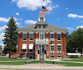
Washington County is a county located in the eastern side of the U.S. state of Colorado. As of the 2020 census, the population was 4,817, making it the least populous “Washington County” in the United States. The county seat is Akron. The county was named in honor of the United States President George Washington.

<span class="mw-page-title-main">Rio Blanco County, Colorado</span> County in Colorado, United States

Rio Blanco County is a county located in the U.S. state of Colorado. As of the 2020 census, the population was 6,529. The county seat is Meeker. The name of the county is the Spanish name for the White River which runs through it.

<span class="mw-page-title-main">Montrose County, Colorado</span> County in Colorado, United States

Montrose County is a county located in the U.S. state of Colorado. As of the 2020 census, the population was 42,679. The county seat is Montrose, for which the county is named.

<span class="mw-page-title-main">Rexburg, Idaho</span> City in Idaho, United States

Rexburg is a city in Madison County, Idaho, United States. The population was 39,409 at the 2020 census. The city is the county seat of Madison County and its largest city. Rexburg is the principal city of the Rexburg, ID Micropolitan Statistical Area, which includes Fremont and Madison counties. The city is home to Brigham Young University–Idaho (BYU-Idaho), a private institution operated by the Church of Jesus Christ of Latter-day Saints.

References

  1. 1 2 "State & County QuickFacts". United States Census Bureau. Archived from the original on July 17, 2011. Retrieved July 1, 2014.
  2. "Find a County". National Association of Counties. Retrieved June 7, 2011.
  3. Idaho.gov - Madison County Archived August 15, 2009, at the Wayback Machine - accessed May 31, 2009
  4. Welcome to Madison County, Idaho
  5. Dave Leip's Atlas of U.S. Presidential Elections
  6. Dave Leip's Atlas of U.S. Presidential Elections
  7. 1 2 Dave Leip's Atlas of U.S. Presidential Elections
  8. Dave Leip's Atlas of U.S. Presidential Elections
  9. "2016 Presidential General Election Data Graphs - Idaho". Dave Leip's Atlas of U.S. Presidential Elections.
  10. "Which counties did Trump win? How high was Idaho's turnout?". Idaho Statesman. November 11, 2016. Retrieved March 17, 2019.
  11. "2016 Presidential Election Statistics". Dave Leip's Atlas of U.S. Presidential Elections. Retrieved May 6, 2019.
  12. Idaho Legislative District Map Archived November 17, 2011, at the Wayback Machine
  13. Idaho Legislative Districts Archived November 10, 2008, at the Wayback Machine
  14. Leip, David. "Dave Leip's Atlas of U.S. Presidential Elections". uselectionatlas.org. Retrieved April 4, 2018.
  15. "US Gazetteer files: 2010, 2000, and 1990". United States Census Bureau. February 12, 2011. Retrieved April 23, 2011.
  16. "Annual Estimates of the Resident Population for Counties: April 1, 2020 to July 1, 2023". United States Census Bureau. Retrieved March 31, 2024.
  17. "U.S. Decennial Census". United States Census Bureau. Retrieved July 1, 2014.
  18. "Historical Census Browser". University of Virginia Library. Retrieved July 1, 2014.
  19. "Population of Counties by Decennial Census: 1900 to 1990". United States Census Bureau. Retrieved July 1, 2014.
  20. "Census 2000 PHC-T-4. Ranking Tables for Counties: 1990 and 2000" (PDF). United States Census Bureau. Archived (PDF) from the original on March 27, 2010. Retrieved July 1, 2014.
  21. 2020 Population and Housing State Data | Utah
  22. "U.S. Census website". United States Census Bureau . Retrieved January 31, 2008.
  23. 1 2 3 "DP-1 Profile of General Population and Housing Characteristics: 2010 Demographic Profile Data". United States Census Bureau. Archived from the original on February 13, 2020. Retrieved January 9, 2016.
  24. "Population, Housing Units, Area, and Density: 2010 - County". United States Census Bureau. Archived from the original on February 13, 2020. Retrieved January 9, 2016.
  25. "DP02 SELECTED SOCIAL CHARACTERISTICS IN THE UNITED STATES – 2006-2010 American Community Survey 5-Year Estimates". United States Census Bureau. Archived from the original on February 13, 2020. Retrieved January 9, 2016.
  26. "DP03 SELECTED ECONOMIC CHARACTERISTICS – 2006-2010 American Community Survey 5-Year Estimates". United States Census Bureau. Archived from the original on February 13, 2020. Retrieved January 9, 2016.
  27. "2020 CENSUS - SCHOOL DISTRICT REFERENCE MAP: Madison County, ID" (PDF). United States Census Bureau . Retrieved March 12, 2024. - Text list
  28. "Community Colleges" (PDF). Budget Hearing. Idaho Legislature. 2020. p. 1-73 (PDF p. 8/14). Retrieved March 12, 2024.

43°47′N111°40′W / 43.79°N 111.66°W / 43.79; -111.66