Camas County, Idaho

Last updated

Camas County
Camas County Courthouse, Fairfield, Idaho, USA.jpg
Camas County Courthouse in Fairfield
Camas County ID Seal.PNG
Map of Idaho highlighting Camas County.svg
Location within the U.S. state of Idaho
Idaho in United States.svg
Idaho's location within the U.S.
Coordinates: 43°28′N114°49′W / 43.47°N 114.81°W / 43.47; -114.81
CountryFlag of the United States.svg United States
StateFlag of Idaho.svg  Idaho
FoundedFebruary 6, 1917
Named for Camas root
Seat Fairfield
Largest cityFairfield
Area
  Total1,079 sq mi (2,790 km2)
  Land1,074 sq mi (2,780 km2)
  Water4.5 sq mi (12 km2)  0.4%
Population
 (2020)
  Total1,077
  Estimate 
(2022)
1,153 Increase2.svg
  Density1/sq mi (0.4/km2)
Time zone UTC−7 (Mountain)
  Summer (DST) UTC−6 (MDT)
Congressional district 2nd
Website camascounty.id.gov

Camas County is a county in the southern portion of the U.S. state of Idaho. The county seat and largest city is Fairfield. [1] The county was established 107 years ago in 1917 by the Idaho Legislature with a partition of Blaine County on February 6. It is named for the camas root, or Camassia, a lily-like plant with an edible bulb found in the region, that Native Americans and settlers used as a food source. As of the 2020 census, the population was 1,077, [2] making it the second-least populous county in the state, after Clark County.

Contents

Camas County is part of the Hailey, ID Micropolitan Statistical Area.

History

Native presence on the Camas Prairie dates back over 11,000 years ago. The Shoshoni, Northern Piute, and Nez Perce migrated annually to the Camas Prairie to gather camas and yampa for their winter food storage. Explorer, Donald Mackenzie discovered the Camas Prairie by 1820 and the area slowly grew in importance as a travel route. Military escorts for wagon trains headed to Oregon started using the route through the Camas Prairie in 1852. The route was later named Goodale Cutoff, for Timothy Goodale who first brought migrants through the Camas Prairie in 1862. When the cavalry was stationed at Fort Boise the southern portion of the Camas Prairie was an important feeding ground for their horses. In 1869, a treaty ratified by the US Senate provided a portion of the "Kansas Prairie" instead of the "Camas Prairie" to be retained by the Bannock Indians. The error may have made by the person who transcribed the treaty. Since there was no "Kansas Prairie" in Idaho, the treaty rights of the Bannocks were ignored. When they found a few settlers were allowing their hogs to feed on the Bannocks' traditional food source, the camas root, they objected (without results), which was a major cause of the Bannock War of 1878. [3] [4]

The Camas Prairie was initially entirely within Alturas County when initial settlement started following the Bannock War. While the Lava mining district near Fairfield was active in the 1880s, Camas County's settlements were primarily agricultural. [5] By the fall of 1881, over 60 farming operations were in existence. Town settlements at Crichton and Soldier occurred almost simultaneously in 1884. Corral was settled no later than 1886. [6] [7] The Camas Prairie became part of Logan County when it was formed in 1889 with the mountainous area north of the prairie remaining within Alturas County. At the 1890 Census, Alturas County contained the Little Smoky precinct with 95 residents while Logan County contained the Corral, Crichton, Soldier, and Spring Creek precincts with a combined population of 805. In 1891, the Idaho Legislature attempted to transfer all five Camas precincts to a new county named Alta. The Idaho Supreme Court found the act unconstitutional. Blaine County included all five Camas precincts when it was organized in 1895. The settlement at Crichton was abandoned in 1896. The decline at Crichton, led to a slight decline to 836 residents within the five Camas precincts at the 1890 census. By 1910, the precincts more than doubled to reach a population of 1,804 residents. A railroad reached the Camas Prairie in 1911 and ran through what is now Fairfield. The railroad's arrival led the majority of settlement in Soldier to locate to what became known as Fairfield. [8] [9] [10] [11]

Geography

According to the United States Census Bureau, the county has a total area of 1,079 square miles (2,790 km2), of which 1,074 square miles (2,780 km2) is land and 4.5 square miles (12 km2) (1.0%) is water. [12] The highest point is Camas County Highpoint at 10,337 ft (3,151 m), on the county's northern border with Blaine County.

Adjacent counties

Demographics

Historical population
CensusPop.Note
1920 1,730
1930 1,411−18.4%
1940 1,360−3.6%
1950 1,079−20.7%
1960 917−15.0%
1970 728−20.6%
1980 81812.4%
1990 727−11.1%
2000 99136.3%
2010 1,11712.7%
2020 1,077−3.6%
2023 (est.)1,232 [13] 14.4%
U.S. Decennial Census [14]
1790–1960, [15] 1900–1990, [16]
1990–2000, [17] 2010–2020 [2]

2020 census

As of the 2020 census, there were 1,077 people living in the county.[ citation needed ]

2010 census

As of the 2010 census, there were 1,117 people, 487 households, and 326 families living in the county. [18] The population density was 1.0 inhabitant per square mile (0.39/km2). There were 831 housing units at an average density of 0.8 units per square mile (0.31 units/km2). [19] The racial makeup of the county was 94.1% white, 0.5% American Indian, 0.3% black or African American, 0.1% Asian, 1.8% from other races, and 3.2% from two or more races. Those of Hispanic or Latino origin made up 6.7% of the population. [18] In terms of ancestry, 24.8% were German, 20.2% were American, 15.1% were English, 8.8% were Irish, and 7.3% were Swedish. [20]

Of the 487 households, 28.1% had children under the age of 18 living with them, 56.3% were married couples living together, 5.1% had a female householder with no husband present, 33.1% were non-families, and 28.3% of all households were made up of individuals. The average household size was 2.29 and the average family size was 2.77. The median age was 44.3 years. [18]

The median income for a household in the county was $44,145 and the median income for a family was $43,092. Males had a median income of $39,022 versus $25,938 for females. The per capita income for the county was $19,659. About 14.1% of families and 16.3% of the population were below the poverty line, including 28.0% of those under age 18 and 4.0% of those age 65 or over. [21]

2000 census

As of the 2000 census, there were 991 people, 396 households, and 287 families living in the county. The population density was 0.8 people per square mile (0.31 people/km2). There were 601 housing units at an average density of 0.6 units per square mile (0.23 units/km2). The racial makeup of the county was 95.16% White, 1.21% Black or African American, 0.30% Native American, 0.20% Asian, 0.91% from other races, and 2.22% from two or more races. 5.55% of the population were Hispanic or Latino of any race. 20.5% were of German, 18.1% American, 15.4% English and 7.4% Irish ancestry.

There were 396 households, out of which 30.80% had children under the age of 18 living with them, 65.20% were married couples living together, 4.50% had a female householder with no husband present, and 27.50% were non-families. 22.20% of all households were made up of individuals, and 8.30% had someone living alone who was 65 years of age or older. The average household size was 2.49 and the average family size was 2.92.

In the county, the population was spread out, with 24.70% under the age of 18, 6.60% from 18 to 24, 28.20% from 25 to 44, 27.50% from 45 to 64, and 13.00% who were 65 years of age or older. The median age was 40 years. For every 100 females there were 104.80 males. For every 100 females age 18 and over, there were 102.20 males.

The median income for a household in the county was $34,167, and the median income for a family was $40,156. Males had a median income of $30,500 versus $21,563 for females. The per capita income for the county was $19,550. About 7.20% of families and 8.30% of the population were below the poverty line, including 7.20% of those under age 18 and 8.50% of those age 65 or over.

Communities

City

Unincorporated communities

Politics

With its small and mostly white population, Camas County is one of the most consistently Republican counties in Idaho, having last backed Democrats in 1960, when it voted for John F. Kennedy.

Third-party candidates have historically performed well in Camas. In 1992, Independent Ross Perot got 29.84% of the vote. In 1996, Reform Party candidate Ross Perot got 17.46%. In 2000, Reform Party candidate Pat Buchanan got 3.94%. In 2016, Evan McMullin got 5.59%.

United States presidential election results for Camas County, Idaho [22]
Year Republican Democratic Third party
No.%No.%No.%
2020 50775.22%14922.11%182.67%
2016 41069.49%11018.64%7011.86%
2012 40269.55%15927.51%172.94%
2008 42268.28%18730.26%91.46%
2004 45075.63%13923.36%61.01%
2000 35970.81%11322.29%356.90%
1996 28352.02%15628.68%10519.30%
1992 20241.56%13427.57%15030.86%
1988 28865.90%13631.12%132.97%
1984 36474.13%12325.05%40.81%
1980 36067.92%14527.36%254.72%
1976 28862.20%16034.56%153.24%
1972 34474.30%9520.52%245.18%
1968 27156.22%11824.48%9319.29%
1964 31655.05%25844.95%00.00%
1960 28446.86%32253.14%00.00%
1956 33755.89%26644.11%00.00%
1952 42565.38%22434.46%10.15%
1948 28950.26%27848.35%81.39%
1944 30148.71%31751.29%00.00%
1940 36749.06%38150.94%00.00%
1936 27437.48%44260.47%152.05%
1932 23433.91%44163.91%152.17%
1928 41363.25%23035.22%101.53%
1924 22635.26%11317.63%30247.11%
1920 40059.08%27640.77%10.15%

Transportation

U.S. Highway 20 runs east–west through the county's center, at elevations just over 5,000 feet (1,520 m) above sea level, connecting west to Mountain Home in Elmore County; to the east it intersects State Highway 75 in Blaine County. The northern terminus of State Highway 46 is at US-20, four miles (6.4 km) east of Fairfield; it runs south over the Mount Bennett Hills into Gooding County and on to Gooding.

Recreation

The Soldier Mountain ski area, opened 76 years ago in 1948, is twelve miles (20 km) north of Fairfield, in the Soldier Mountains of the Sawtooth National Forest.

Education

There is one school district in the county: Camas County School District 121. [23]

The county is in the catchment area, but not the taxation zone, for College of Southern Idaho. [24]

See also

Notes

    Related Research Articles

    <span class="mw-page-title-main">Power County, Idaho</span> County in Idaho, United States

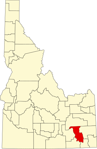
    Power County is a county located in the U.S. state of Idaho. As of the 2020 Census, the county had a population of 7,878. The county seat and largest city is American Falls. The county was created by the Idaho Legislature on January 30, 1913, by a partition of Cassia County. It is named for an early hydroelectric power plant (1902) at the American Falls.

    <span class="mw-page-title-main">Lincoln County, Idaho</span> County in Idaho, United States

    Lincoln County is a county located in the U.S. state of Idaho. As of the 2020 census, the population was 5,127. The county seat and largest city is Shoshone. The county is named after President Abraham Lincoln. The Idaho Territory was created in 1863, during the Lincoln Administration of 1861–65.

    <span class="mw-page-title-main">Lewis County, Idaho</span> County in Idaho, United States

    Lewis County is a county located in the north central region of the U.S. state of Idaho. As of the 2020 census, the population was 3,533, making it the fourth-least populous county in Idaho. The county seat is Nezperce, and Kamiah is the largest city. Partitioned from Nez Perce County and established in 1911, it was named after the explorer Meriwether Lewis. Most of the county is within the Nez Perce Indian Reservation, though Native Americans comprise less than 6% of the county population. Similar to the opening of lands in Oklahoma, the U.S. government opened the reservation for white settlement in November 1895. The proclamation had been signed less than two weeks earlier by President Cleveland.

    <span class="mw-page-title-main">Jefferson County, Idaho</span> County in Idaho, United States

    Jefferson County is a county located in the U.S. state of Idaho. As of the 2020 Census, the county's population was 30,891. The county seat and largest city is Rigby. The county was established in 1913 and named after Thomas Jefferson, the third U.S. President. Jefferson County is part of the Idaho Falls, ID Metropolitan Statistical Area.

    <span class="mw-page-title-main">Gooding County, Idaho</span> County in Idaho, United States

    Gooding County is a county located in the U.S. state of Idaho. As of the 2020 census, the population was 15,598. Its county seat is Gooding. The county was created by the Idaho Legislature on January 28, 1913, by a partition of Lincoln County. It is named for Frank R. Gooding, the 7th governor and a United States Senator from Idaho.

    <span class="mw-page-title-main">Gem County, Idaho</span> County in Idaho, United States

    Gem County is a county in the U.S. state of Idaho. As of the 2020 census, the population was 19,123. The county seat and largest city is Emmett.

    <span class="mw-page-title-main">Franklin County, Idaho</span> County in Idaho, United States

    Franklin County is a county located in the U.S. state of Idaho. As of the 2020 Census the county had a population of 14,194. The county seat and largest city is Preston. The county was established in 1913 and named after Franklin D. Richards, an Apostle of the Church of Jesus Christ of Latter-day Saints. It is the only Franklin County in the United States that is not named after Benjamin Franklin. Franklin County is part of the Logan, UT-ID Metropolitan Statistical Area.

    <span class="mw-page-title-main">Elmore County, Idaho</span> County in Idaho, United States

    Elmore County is a county in the U.S. state of Idaho. As of the 2020 census, the population was 28,666. The largest city and county seat is Mountain Home.

    <span class="mw-page-title-main">Custer County, Idaho</span> County in Idaho, United States

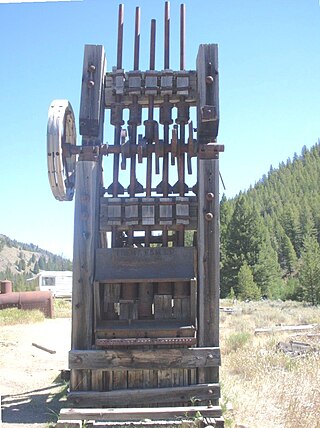
    Custer County is a rural mountain county in the center of the U.S. state of Idaho. As of the 2020 census, the population was 4,275, making it the fifth-least populous county in Idaho. The county seat is Challis. Established in 1881, the county was named for the General Custer Mine, where gold was discovered five years earlier. Custer County relies on ranching, mining, and tourism as its main resources.

    <span class="mw-page-title-main">Clark County, Idaho</span> County in Idaho, United States

    Clark County is a rural county in the U.S. state of Idaho; its county seat and largest city is Dubois. As of the 2020 census, the population was 790, making it the least populous county in the state.

    <span class="mw-page-title-main">Caribou County, Idaho</span> County in Idaho, United States

    Caribou County is a county located in the U.S. state of Idaho. As of the 2020 Census the county had a population of 7,027. The county seat and largest city is Soda Springs.

    <span class="mw-page-title-main">Butte County, Idaho</span> County in Idaho, United States

    Butte County is a rural county located in the U.S. state of Idaho. As of the 2020 census, the population was 2,574, making it the third-least populous county in Idaho. Its county seat and largest city is Arco. The county was established in 1917 from parts of Bingham, Blaine, and Jefferson counties. The county gained territory in the Clyde area from Custer County in 1937 to reach its present boundary.

    <span class="mw-page-title-main">Blaine County, Idaho</span> County in Idaho, United States

    Blaine County is a county in the U.S. state of Idaho. As of the 2020 United States Census, the population was 24,272. The county seat and largest city is Hailey. It is also home to the Sun Valley ski resort, adjacent to Ketchum.

    <span class="mw-page-title-main">Bingham County, Idaho</span> County in Idaho, United States

    Bingham County is a county in the U.S. state of Idaho. As of the 2020 census, the population was 47,992. The county seat and largest city is Blackfoot.

    <span class="mw-page-title-main">Bannock County, Idaho</span> County in Idaho, United States

    Bannock County is a county in the southeastern part of Idaho. As of the 2020 census, the population was 87,018, making it the sixth-most populous county in Idaho. The county seat and largest city is Pocatello. The county was established in 1893 and named after the local Bannock tribe. It is one of the counties with territories included in the Fort Hall Indian Reservation of the federally recognized Shoshone-Bannock Tribes.

    <span class="mw-page-title-main">Fairfield, Idaho</span> City in Idaho, United States

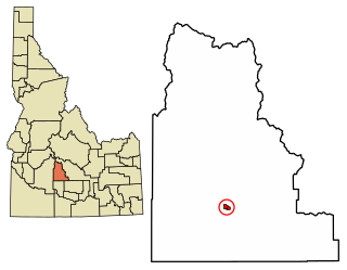
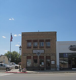
    Fairfield is the county seat of and the only village in Camas County, Idaho. The population was 410 at the time of 2010 census, nearly half of the rural county's population.

    <span class="mw-page-title-main">Cottonwood, Idaho</span> City in the United States

    Cottonwood is a city in Idaho County, Idaho. On the Camas Prairie in north central Idaho, the population was 900 at the 2010 census, down from 944 in 2000. It is just west of U.S. Route 95, between Grangeville and Lewiston.

    <span class="mw-page-title-main">Ferdinand, Idaho</span> City in Idaho, United States

    Ferdinand is a city in Idaho County, Idaho, United States. The population was 159 at the 2010 census, up from 145 in 2000. At the southern end of the Nez Perce Indian Reservation, it was founded by F.M. Bieker shortly after the reservation was opened for settlement in 1895. It was named after Ferdinand, Indiana, where his mother's family had lived.

    <span class="mw-page-title-main">Grangeville, Idaho</span> City in Idaho, United States

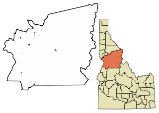
    Grangeville is the largest city in and the county seat of Idaho County, Idaho, United States, in the north central part of the state. Its population was 3,141 at the 2010 census, down from 3,228 in 2000.

    <span class="mw-page-title-main">Nezperce, Idaho</span> City in Idaho, United States

    Nezperce is a city in and the county seat of Lewis County, Idaho, United States. The population was 466 at the 2010 census, down from 523 in 2000. Nezperce is named for the local Nez Perce tribe of Native Americans. There is one school district, Nezperce School District #302.

    References

    1. "Find a County". National Association of Counties. Archived from the original on May 31, 2011. Retrieved June 7, 2011.
    2. 1 2 "State & County QuickFacts". United States Census Bureau. Retrieved January 16, 2024.
    3. "idahohistory.net" (PDF). www.idahohistory.net. Archived (PDF) from the original on November 8, 2007. Retrieved April 4, 2018.
    4. "Camas Prairie (Camas County)" (PDF). Idaho State Historical Society. Idaho State Historical Society. Archived from the original (PDF) on February 10, 2017. Retrieved February 5, 2017.
    5. "McCarter Family History". McCarter Family History. Retrieved February 5, 2017.
    6. "Maps of Camas Prairie and Corral Creek". McCarter Family History. Retrieved February 5, 2017.
    7. Idaho Atlas of Historical County Boundaries. Chicago: The Newberry Library. 2010. pp. 10–11, 12, 17, 36, 65, 137.
    8. Report on Population of the United States at the Eleventh Census: 1890. Washington: Government Printing Office. 1895. pp.  99–100.
    9. Census Reports Volume I: Twelfth Census of the United States Taken in the Year 1900. Washington: United States Census Office. 1901. p. 111.
    10. Thirteenth Census of the United States Taken in the Year 1910: Volume II. Washington: Government Printing Office. 1913. p. 414.
    11. "US Gazetteer files: 2010, 2000, and 1990". United States Census Bureau. February 12, 2011. Retrieved April 23, 2011.
    12. "Annual Estimates of the Resident Population for Counties: April 1, 2020 to July 1, 2023". United States Census Bureau. Retrieved March 31, 2024.
    13. "U.S. Decennial Census". United States Census Bureau. Retrieved June 28, 2014.
    14. "Historical Census Browser". University of Virginia Library. Retrieved June 28, 2014.
    15. "Population of Counties by Decennial Census: 1900 to 1990". United States Census Bureau. Retrieved June 28, 2014.
    16. "Census 2000 PHC-T-4. Ranking Tables for Counties: 1990 and 2000" (PDF). United States Census Bureau. Archived (PDF) from the original on March 27, 2010. Retrieved June 28, 2014.
    17. 1 2 3 "DP-1 Profile of General Population and Housing Characteristics: 2010 Demographic Profile Data". United States Census Bureau. Archived from the original on February 13, 2020. Retrieved January 19, 2016.
    18. "Population, Housing Units, Area, and Density: 2010 - County". United States Census Bureau. Archived from the original on February 13, 2020. Retrieved January 19, 2016.
    19. "DP02 SELECTED SOCIAL CHARACTERISTICS IN THE UNITED STATES – 2006-2010 American Community Survey 5-Year Estimates". United States Census Bureau. Archived from the original on February 13, 2020. Retrieved January 19, 2016.
    20. "DP03 SELECTED ECONOMIC CHARACTERISTICS – 2006-2010 American Community Survey 5-Year Estimates". United States Census Bureau. Archived from the original on February 13, 2020. Retrieved January 19, 2016.
    21. Leip, David. "Dave Leip's Atlas of U.S. Presidential Elections". uselectionatlas.org. Retrieved April 4, 2018.
    22. "2020 CENSUS - SCHOOL DISTRICT REFERENCE MAP: Camas County, ID" (PDF). U.S. Census Bureau . Retrieved March 11, 2024. - Text list
    23. "Community Colleges" (PDF). Legislative Budget Book. Idaho Legislature. 2016. p. 1-81 (PDF p. 3/9). - See area 1 in: "TITLE 33 EDUCATION CHAPTER 21 JUNIOR COLLEGES". Idaho Legislature . Retrieved March 12, 2024.

    43°28′N114°49′W / 43.47°N 114.81°W / 43.47; -114.81