Lunar Crater volcanic field

Last updated

Lunar Crater volcanic field
Lunar Crater July 2013.JPG
Aerial view of Lunar Crater and surrounding vents
Highest point
Elevation 2,255 m (7,398 ft) [1]
Coordinates 38°N116°W / 38°N 116°W / 38; -116 [2]
Geography
Relief map of U.S., Nevada.png
Red triangle with thick white border.svg
Lunar Crater volcanic field
Geology
Last eruption 38,100 ± 10,000 years ago

Lunar Crater volcanic field is a volcanic field in Nye County, Nevada. It lies along the Reveille and Pancake Ranges and consists of over 200 vents, mostly small volcanic cones with associated lava flows but also several maars, including one maar named Lunar Crater. Some vents have been eroded so heavily that the structures underneath the volcanoes have been exposed. Lunar Crater itself has been used as a testing ground for Mars rovers and as training ground for astronauts.

Contents

The volcanic field has formed on top of older, Oligocene to Miocene age volcanic rocks and calderas, but its own activity commenced only about 6 million years ago. The reasons for the volcanic activity there are not well known. The volcanic field has produced various types of basaltic magma and also trachyte; the most recent eruption was about 38,000 years ago and renewed activity is possible.

Etymology and human use

Astronaut training at Lunar Crater S72-48854.jpg
Astronaut training at Lunar Crater

The volcanic field is named after the Lunar Crater vent, [3] the most distinctive vent in the volcanic field. [1] The area is dry and rugged and thus uninhabited. [4] Owing to its diverse geology and accessibility, Lunar Crater volcanic field was used to test prototype Mars rovers [5] and as a training ground for astronauts [6] for the Moon landings. [4] Parts of the volcanic field lie within the Palisade Mesa wilderness study area, [7] and Lunar Crater is classified as a National Natural Landmark, known as Lunar Crater National Natural Landmark. [8]

Geography and geomorphology

The Lunar Crater volcanic field is located in Nye County, [9] in the central part [10] of the state of Nevada. [3] The field lies almost north from Rachel, [11] 62 miles (100 km) east-northeast from Tonopah [12] and 250 miles (400 km) north of Las Vegas. [13] Two highways run past its western and eastern margin, [14] and both Nevada State Route 375 and U.S. Route 6 pass through the volcanic field; [2] the volcanic field is about halfway between Tonopah and Ely along Route 6 [15] and dirt roads run through the area. [8] A parking place lies at the foot of the Easy Chair crater [4] and another on the rim of Lunar Crater. [16]

The volcanic field covers a 50 miles (80 km) long and 12.4–6.2 miles (20–10 km) wide area [3] with a surface of about 390 square miles (1,000 km2). [17] Lunar Crater volcanic field extends in north-northeast to south-southwest direction [14] along the Reveille Range and Pancake Range and between Railroad Valley to the southeast and Hot Creek Valley/ [2] Big Sand Springs Valley/Kawich Valley in the northwest. [18] Over 200 vents [lower-alpha 1] are located within the field, [19] mostly monogenetic volcanoes with [3] 0.62–6.21 miles (1–10 km) long [22] aa (blocky lava with a jagged surface [23] ) [24] lava flows along with a few lava domes, [3] dykes, [25] four [26] maars (craters formed by gas or steam explosions [27] ), scoria cones, [10] tuff rings and volcano clusters; [3] cones reach heights of 660 feet (200 m) and widths of 3,900 feet (1,200 m) and often are open on one side while fissure vents are often associated with elongated ramparts. [28] The vents reach elevations of 1,800–2,100 meters (6,000–7,000 ft). [29] The Hot Creek geothermal field is within 18 kilometers (11 mi) from the Lunar Crater volcanic field but does not appear to have its heat source there. [30]

Erosion has led to topographic inversion at some volcanoes, forming lava-capped mesas (hills with flat tops [31] ), [32] broadening and flattening volcanic cones [33] and has led to the formation of soils and drainage networks especially on older vents; [34] additionally, desert pavement and wind-transported material has accumulated on some lava flows. [10]

The 5.4 square miles (14 km2) [35] Lunar Lake playa [lower-alpha 2] is located in the northern part of the volcanic field; [37] it lies at 5,740 feet (1,750 m) elevation [35] and collects water from local drainages, [38] which only ephemerally contain water. [36]

Individual vents

Lunar Crater 2014-07-18 16 28 48 Panorama of the Lunar Crater, Nevada.JPG
Lunar Crater

Lunar Crater itself is almost circular and embedded in basaltic lavas, underlying tuffs and two older volcanic cones including Lunar Cone. A tephra ring (ring of volcanic material) defines a 3,600 feet (1,100 m) wide and 430 feet (130 m) deep crater [14] which is the endpoint of a small canyon that appears to predate the formation of Lunar Crater. An alluvial fan and a playa fill the bottom of the crater, [2] which is the lowest point in this volcanic field, [4] while its margins are surrounded by tephra beds including ash, lapilli, scoria and tuff blocks; it appears that most of these are older rocks that were torn out of the ground and ejected during the formation of Lunar Crater. [39] Cinder cones are found at Lunar Crater; [29] two vents east and southeast from Lunar Crater are known as North Kidney Butte and South Kidney Butte. [40]

The extremely well preserved [17] Marcath cone (also known as Black Rock [41] [1] ) only a few kilometers north of U.S. Route 6 [42] is an approximately 490 feet (150 m) high and 1,600 by 3,000 feet (500 m × 900 m) wide volcanic cone, which formed over a fissure vent. Lava flows emanate from its western side, which reach lengths of several kilometers and after bypassing an older cone emerge onto the valley floor. [43] The flows have flow fronts about 16 feet (5 m) high; [44] lobes, inflation structures and material rafted off the cone appear on the lava flows, [45] which are classified as aa lava. [46] During the eruption of Marcath, tephra was emplaced northeastward for over 3.1 miles (5 km) and is formed by lapilli and scoria; [44] another tephra deposit extends south from Marcath cone. [47] The Marcath cone forms the Marcath unit, [43] the total volume of rocks is about 0.024 cubic miles (0.1 km3). [48]

The eroded [49] Kimana ("butterfly" in Shoshone) volcano is formed by aa lava flows and pyroclastic deposits that cover an area of 10 square miles (26 km2) and have a volume of 0.096 cubic miles (0.4 km3). [50] Broken Cone volcano along with several neighbouring bodies likely formed atop a fault (an offset in the ground formed by tectonic movements [51] ) and consists of a pyroclastic pile, while the neighbouring bodies are remnants of lava flows. [52] There are also dykes, and the volcano may have featured a now-disappeared scoria cone. [53]

Easy Chair is an about 790 feet (240 m) high and c.1.6 miles (2.5 km) long ridge in the Lunar Lake basin. The ridge is formed by pyroclastics emplaced on a fissure vent and partly buried/destroyed by two scoria cones and a maar; the cones in turn are the source of a lava flow field. The total volume of this structure is about 0.024 cubic miles (0.1 km3), without counting a poorly measured tephra deposit. [10]

Bea's Crater just southeast from Marcath volcano [38] is the third maar in the volcanic field [54] and appears to have had a complex history. [55] It formed within a dense cluster of older vents as two overlapping roughly 1,440 feet (440 m) and 3,440 feet (1,050 m) wide craters with a maximum depth of 482 feet (147 m); at the bottom lies a playa [38] and to its north lies Northeast Cone, which formed together with Bea's Crater. [56] Deposits including lapilli tuffs and possibly older volcanics surround Bea's Crater. [57] The so-called "Middle Maar" is the fourth maar in the volcanic field. [55]

Dark Peak in the Reveille Range is a Pliocene volcano whose underground structure, a dyke (a steep, tabular magma intrusion into rock [58] ), is exposed as an almost 0.62 miles (1 km) long body that also contains the main conduit of the volcano. [59] There are also other traces of dykes [60] that formed when magma propagated away from the vent, [61] and a subdued lava field west from the vents. [62] Erosion has removed most of the volcano, exposing part of the underlying terrain. [63]

Geology

Regional

Intraplate volcanoes occur in many places of the Western United States, including along the Sierra Nevada, on the Colorado Plateau, the Basin and Range province and the Rio Grande Rift. [64] Lunar Crater volcanic field lies within the Basin and Range province [3] along with other volcanic fields, but in an unusually central [lower-alpha 3] position. [66] Upwelling of asthenospheric mantle in response to the tectonic regime of the Basin and Range may be responsible for the eruptive activity there, although other processes have also been proposed [17] such as mantle downwelling and compensating flow in the asthenosphere; [67] older volcanism in the region is related to the subduction of the Farallon Plate. [68]

The Basin and Range province has had a complicated geological history [69] and in the last 20 million years [41] features extensional tectonics (tectonic processes involving a dilatation of the crust [70] ) [66] represented by normal faults (faults where the downmoving blocks move in a way consistent with gravity [51] ). [71] The crust is relatively thin, [69] 19–21 miles (30–33 km), [17] and underpinned by an unusually hot mantle [69] which underneath Lunar Crater volcanic field has a slow seismic velocity. [72] Crustal heat flow is low. [64]

The Lunar Crater volcanic field is part of a larger [14] Pliocene and Pleistocene [66] volcanic zone that extends over the Crater Flat area [73] southward into Death Valley, California; [14] it is known as the "Death Valley-Pancake Range basalt zone". [65] This volcanic zone has received attention due to its proximity and relationship to Yucca Mountain, where a nuclear waste repository is planned, [74] although a relationship between Lunar Crater volcanic field and volcanics close to Yucca Mountain is debatable. [75]

Local

Older volcanic activity occurred in the field during the Oligocene and Miocene, generating calderas (usually large craters formed by the explosion or collapse of a volcano [76] ) [19] such as the Central Nevada Caldera Complex [54] and the Lunar Lake caldera which underlies much of the northern Lunar Crater volcanic field. [77] The volcanism produced ignimbrites, andesitic lavas and tuffs such as the 24 million years old Buckwheat Rim Tuff that Lunar Crater is embedded in; some of these volcanic rocks form structural blocks such as the Citadel Mountain block [3] and the Pancake Range [72] and others are correlated to ignimbrite sheets elsewhere in Nevada. [78] An early caldera-forming ignimbritic phase was followed by an andesitic lavic phase, [64] and in the last 11 million years basaltic eruptions have taken place in the Basin and Range. [41]

These older volcanics also form the basement (underground rock surface [79] ) in the area, while parts of the region are covered by alluvium (sediment that was transported by water [80] ); [81] sometimes the older volcanics are buried beneath this alluvium and playa deposits. [10] In turn, Paleozoic rocks crop out at the northeastern margin of the Lunar Crater volcanic field [26] and underlie the older volcanics. [64] [54] Finally, Proterozoic crystalline rocks occur within the crust. [17] The geology of the region is dominated by fault-separated blocks with only little folding. [78]

Some vents form alignments, and the positions of (not all) individual volcanoes appear to be controlled by normal faults, [3] although isolated volcanoes or clusters also occur [19] and the ascent of magma at many vents was influenced by the general tectonic regime rather than by specific faults. [82] The faults have also influenced the older volcanism [69] and that in turn the Lunar Crater volcanic field. [83] Volcanic activity has buried many of the faults in the area [69] and there is little evidence of ongoing faulting and deformation. [84]

Composition

A close-up of the youngest lava flow 2014-07-18 17 02 18 Close view of the west edge of the Black Rock Lava Flow, Nevada.JPG
A close-up of the youngest lava flow

The Lunar Crater vents have erupted alkali basalts; trachyte occurs at two lava domes [3] and basalts, basanite, tephrite and trachybasalt have been reported as well. [85] In general, the volcanic rocks define an ocean island basalt suite that originated in the asthenosphere. [26] The rocks contain phenocrysts. [lower-alpha 4] inclusions and nodules. [lower-alpha 5] Alteration has formed chlorite, epidote and sericite. [88] In the northern part of the volcanic field, lavas have a porphyritic (with a texture characterized by visible crystals [89] ) appearance. [17]

The magma appears to originate from a heterogeneous mantle and ponds and crystallizes underneath and inside the crust [90] but without stalling in long-lived magma chambers, [91] before rapidly rising to the surface. [92] Each volcano was supplied by one batch of magma. [26]

Climate and vegetation

Winter landscape in the Reveille Range Reveille Range (19356297123).jpg
Winter landscape in the Reveille Range

The climate is continental [29] and arid, [44] with annual precipitation of about 4.7 inches (12 cm). Mean temperatures are about 54 °F (12 °C), with maxima and minima of 90 °F (32 °C) and 18 °F (−8 °C) respectively. [12] Vegetation is scarce [44] and consists mostly of sagebrush steppe with bushes like greasewood and saltbrush with grass such as Indian ricegrass underneath. [4] [12] The Lunar Crater is also the type location of the "Lunar Crater Howell's-buckwheat", Johanneshowellia crateriorum . [93]

Eruption history

The volcanic field was active in the Miocene [19] /Pliocene and Pleistocene, [3] with the oldest eruptions dated to about 6 million years ago. [19] Volcanism occurred in four stages, [94] with activity peaking every 1-2 million years. [95] The southern volcanics on Reveille Range [19] and in Kawich Valley [72] are the older ones, while more recent eruptions occurred farther north on Pancake Range although at any given point of time the field was active over a large area. As a consequence of the long duration of volcanism, the various volcanic centers have been eroded at varying degrees [19] while volcanism moved to the north [96] at a rate of about 0.39 inches per year (1 cm/year). [97] A mean magma flux rate of 4.1×10⁻⁶ cubic miles per year (0.000017 km3/a) has been reported for Lunar Crater volcanic field, [98] with a tendency to decrease over time [95] and changes in the composition. [17]

Many eruptions in Lunar Crater volcanic field have been dated; aside from radiometric dating [99] differences in the grade of weathering and erosion have also been used to determine the relative age of volcanic units [78] as older vents are often degraded and buried by soils: [100]

Lunar Crater's own age is not known, [3] a tephra potentially correlated to it may have been emplaced 600,000 ± 30,000 to 224,000 ± 43,000 years ago. Scarce traces of erosion imply a late Pleistocene age, however, [14] with a more recent age estimate of 190,000 - 72,000 years ago. [20] Bea's Crater is also not directly dated but may be 300,000 - 100,000 years old. [38]

The emplacement of individual vents often began with explosive eruptions that formed mounds, before effusive eruptions (eruptions characterized by the production of lava flows [101] ) generated lava flows. [102] The volcanic eruptions had characteristics of Hawaiian or Strombolian eruptions, with maars and tuff rings forming where ascending magma interacted with groundwater [19] and volcanic cones where ejecta from the vent piled up and formed a cone. [103] In some places, several eruptions occurred over timespans of over one million years and gave rise to closely spaced vents. [3] Lava flows were produced at rates of about 35–3,531 cubic feet per second (1–100 m3/s) [22] and at Kimana and Broken Cone probably occurred through lateral vents. [104] The Marcath eruption may have lasted up to 20 days; [105] it probably occurred during southwesterly wind and formed a 3.7–5.0 miles (6–8 km) high eruption column. [106]

Most recent eruption and hazards

The most recent eruption occurred 38,000 ± 10,000 years ago [3] and formed the Marcath (or Black Rock) [lower-alpha 6] unit. [66] Tephra from the volcanic field is mixed with sediments less than 18,000 - 9,500 years old [108] and the Black Rock lava flow was once considered to be of early Holocene age but is now considered to be Pleistocene. [1] In light of the recent activity [17] future eruptions are possible, and thus the volcanic field could be considered active. [19] Scoria cone forming eruptions can be hazardous owing to the ejection of ballistic blocks, generation on lava flows and tephra which can disrupt air traffic, even though such eruptions are usually of small volume. [109]

Notes

  1. The exact number of vents is not known [19] as many of them are eroded or otherwise degraded [20] and some volcanoes may be buried under sediments in the basins. [18] Older tephra deposits crop out in a quarry. [21]
  2. Dry lake [36]
  3. Recent volcanism in the Basin and Range province usually occurs at the margins of the province [13] where it has migrated to over time. [65]
  4. Phenocrysts include amphibole, [10] clinopyroxene, olivine, plagioclase [86] and sanidine in the trachytes, [48]
  5. Inclusions and nodules are formed by clinopyroxenite, dunite, [87] gabbro, [10] harzburgite, lherzolite, [87] peridotite, [88] spinel and wehrlite [87]
  6. Formerly it was dated to be 350,000 ± 50,000 years old. [107]

Related Research Articles

<span class="mw-page-title-main">Volcano</span> Rupture in the crust of a planet that allows lava, ash, and gases to escape from below the surface

A volcano is a rupture in the crust of a planetary-mass object, such as Earth, that allows hot lava, volcanic ash, and gases to escape from a magma chamber below the surface.

<span class="mw-page-title-main">Volcanic cone</span> Landform of ejecta from a volcanic vent piled up in a conical shape

Volcanic cones are among the simplest volcanic landforms. They are built by ejecta from a volcanic vent, piling up around the vent in the shape of a cone with a central crater. Volcanic cones are of different types, depending upon the nature and size of the fragments ejected during the eruption. Types of volcanic cones include stratocones, spatter cones, tuff cones, and cinder cones.

<span class="mw-page-title-main">Antofagasta de la Sierra</span> Volcanic field in Argentina

Antofagasta de la Sierra is a volcanic field in Argentina. The main type of volcanic edifice in the area are scoria cones, it is formed by the La Laguna, Jote and Alumbrera volcanoes. The first and last of these form a sub-group which is better researched. Various dating methods have yielded ages from several million to several hundred thousand years ago, but some vents appear to be of Holocene age.

<span class="mw-page-title-main">Payún Matrú</span> Volcano in Argentina

Payún Matrú is a shield volcano in the Reserva Provincial La Payunia of the Malargüe Department, south of the Mendoza Province in Argentina. It lies in the back-arc region of the Andean Volcanic Belt, and was formed by the subduction of the Nazca Plate beneath the South American Plate. Payún Matrú, along with the Llancanelo, Nevado and Salado Basin volcanic fields, form the Payenia province. It has been proposed as a World Heritage Site since 2011.

<span class="mw-page-title-main">Cerro Azul (Chile volcano)</span> Mountain in Curicó Province, Chile

Cerro Azul, sometimes referred to as Quizapu, is an active stratovolcano in the Maule Region of central Chile, immediately south of Descabezado Grande. Part of the South Volcanic Zone of the Andes, its summit is 3,788 meters (12,428 ft) above sea level, and is capped by a summit crater that is 500 meters (1,600 ft) wide and opens to the north. Beneath the summit, the volcano features numerous scoria cones and flank vents.

<span class="mw-page-title-main">Vulcanian eruption</span> Volcanic eruption with dense ash clouds

A Vulcanian eruption is a type of volcanic eruption characterized by a dense cloud of ash-laden gas exploding from the crater and rising high above the peak. They usually commence with phreatomagmatic eruptions which can be extremely noisy due to the rising magma heating water in the ground. This is usually followed by the explosive clearing of the vent and the eruption column is dirty grey to black as old weathered rocks are blasted out of the vent. As the vent clears, further ash clouds become grey-white and creamy in colour, with convolutions of the ash similar to those of Plinian eruptions.

<span class="mw-page-title-main">Quetrupillán</span> Mountain in Chile

Quetrupillán is a stratovolcano located in Los Ríos Region of Chile. It is situated between Villarrica and Lanín volcanoes, within Villarrica National Park. Geologically, Quetrupillán is located in a tectonic basement block between the main traces of Liquiñe-Ofqui Fault and Reigolil-Pirihueico Fault.

<span class="mw-page-title-main">Haruj</span> Libyan mountain range

Haruj is a large volcanic field spread across 42,000–45,000 km2 (16,000–17,000 sq mi) in central Libya. It is one of several volcanic fields in Libya along with Tibesti, and its origin has been attributed to the effects of geologic lineaments in the crust.

<span class="mw-page-title-main">Phreatomagmatic eruption</span> Volcanic eruption involving both steam and magma

Phreatomagmatic eruptions are volcanic eruptions resulting from interaction between magma and water. They differ from exclusively magmatic eruptions and phreatic eruptions. Unlike phreatic eruptions, the products of phreatomagmatic eruptions contain juvenile (magmatic) clasts. It is common for a large explosive eruption to have magmatic and phreatomagmatic components.

<span class="mw-page-title-main">Cinder cone</span> Steep hill of pyroclastic fragments around a volcanic vent

A cinder cone is a steep conical hill of loose pyroclastic fragments, such as volcanic clinkers, volcanic ash, or scoria that has been built around a volcanic vent. The pyroclastic fragments are formed by explosive eruptions or lava fountains from a single, typically cylindrical, vent. As the gas-charged lava is blown violently into the air, it breaks into small fragments that solidify and fall as either cinders, clinkers, or scoria around the vent to form a cone that often is symmetrical; with slopes between 30 and 40°; and a nearly circular ground plan. Most cinder cones have a bowl-shaped crater at the summit.

<span class="mw-page-title-main">Blue Lake Crater</span> Volcanic crater in Oregon, United States

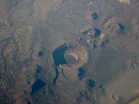
Blue Lake Crater is a maar, or a broad, low-relief volcanic crater, in the U.S. state of Oregon. Located in Jefferson County, it consists of three overlapping craters, which hold Blue Lake. The drainage basin for Blue Lake has very steep, forested slopes and is mostly part of the explosion crater left by the volcano's eruption. The volcano lies within the Metolius River basin, which supports a wide array of plant life, large and small mammals, and more than 80 bird species. In 2009, Governor of Oregon Ted Kulongoski signed a bill designating the Metolius River basin as an area of critical concern, preventing large-scale development on the land and protecting its wildlife.

<span class="mw-page-title-main">Sollipulli</span> Volcanic mountain in Chile

Sollipulli is an ice-filled volcanic caldera and volcanic complex, which lies southeast of the small town of Melipeuco in the La Araucanía Region, Chile. It is part of the Southern Volcanic Zone of the Andes, one of the four volcanic belts in the Andes chain.

<span class="mw-page-title-main">Ceboruco</span> Volcano in central western Mexico

Ceboruco is a dacitic stratovolcano located in Nayarit, Mexico, northwest of the Trans-Mexican Volcanic Belt. The largest eruption, the Jala Plinian eruption, was around 930 AD ±200, VEI 6, releasing 11 cubic kilometres (2.6 cu mi) of tephra. The most recent and best documented eruption from Ceboruco lasted from 1870–1875, with fumarole activity lasting well into the 20th century. The mountain features one large caldera, created during the Jala eruption, with a smaller crater nested inside that formed when the Dos Equis lava dome collapsed during the Coapales eruption around 1100 AD. Within both of these craters, are several explosive volcanic features, including scoria deposits, lava domes, and pyroclastic domes, or cinder cone volcanoes.

<span class="mw-page-title-main">Andagua volcanic field</span> Volcanic field in Peru

The Andagua volcanic field is a volcanic field in southern Peru which includes a number of cinder cones, lava domes and lava flows which have filled the Andagua Valley. The volcanic field is part of a larger volcanic province that clusters around the Colca River and is mostly of Pleistocene age, although the Andagua sector also features volcanic cones with historical activity, with the last eruption about 370 years ago. Eruptions were mostly effusive, generating lava flows, cones and small eruption columns. Future eruptions are possible, and there is ongoing fumarolic activity. Volcanic activity in the field has flooded the Andahua valley with lava flows, damming local watersheds in the Laguna de Chachas, Laguna Mamacocha and Laguna Pumajallo lakes and burying the course of the Andagua River. The Andahua valley segment of the larger volcanic province was declared a geopark in 2015.

<span class="mw-page-title-main">Pali-Aike volcanic field</span> Cluster of volcanoes in Argentina and Chile

The Pali-Aike volcanic field is a volcanic field along the Argentina–Chile border. It is part of a family of back-arc volcanoes in Patagonia, which formed from processes involving the collision of the Chile Ridge with the Peru–Chile Trench. It lies farther east than the Austral Volcanic Zone, the volcanic arc that makes up the Andean Volcanic Belt at this latitude. Pali-Aike formed over sedimentary rock of Magallanes Basin, a Jurassic-age basin starting from the late Miocene as a consequence of regional tectonic events.

<span class="mw-page-title-main">Cima volcanic field</span> Volcanic field in San Bernardino County, California

Cima volcanic field is a volcanic field in San Bernardino County, California, close to the border with Nevada. The volcanic field covers a surface area of 600 km2 (230 sq mi) within the Mojave National Preserve west of the Cima Dome and consists of about 40 volcanic cones with about 60 lava flows. The volcanic cones range from simple cones over multi-cratered mountains to eroded hills, and lava flows are up to 9.1 km (5.7 mi) long. At least one lava tube exists in the field and can be visited.

<span class="mw-page-title-main">Big Pine volcanic field</span> Volcanic field in Inyo County, California

Big Pine volcanic field is a volcanic field in Inyo County, California. The volcanic field covers a surface area of 500 square kilometres (190 sq mi) within the Owens Valley east of the Sierra Nevada and consists of lava flows, one rhyolitic coulee and about 40 volcanic vents including cinder cones. Some vents are simple conical cinder cones while others are irregular scoria cones. Glaciers and former lakes have modified lava flows.

<span class="mw-page-title-main">Bayuda volcanic field</span>

Bayuda volcanic field is a volcanic field in Sudan, within the Bayuda Desert. It covers a surface of about 11 by 48 kilometres and consists of a number of cinder cones as well as some maars and explosion craters. These vents have erupted 'A'ā lava flows.

<span class="mw-page-title-main">Sand Mountain Volcanic Field</span> Volcanic field in Oregon

The Sand Mountain Volcanic Field is a volcanic field in the upper McKenzie River watershed, located in the United States in Oregon. Part of the Cascade Volcanic Arc, it lies southwest of Mount Jefferson and northwest of Belknap Crater and Mount Washington. Its highest elevation is 5,463 feet (1,665 m).

<span class="mw-page-title-main">Honolulu Volcanics</span> Volcanic field in Oʻahu, Hawaiʻi

The Honolulu Volcanics are a group of volcanoes which form a volcanic field on the island of Oʻahu, Hawaiʻi, more specifically in that island's southeastern sector and in the city of Honolulu from Pearl Harbor to the Mokapu Peninsula. It is part of the rejuvenated stage of Hawaiian volcanic activity, which occurred after the main stage of volcanic activity that on Oʻahu built the Koʻolau volcano. These volcanoes formed through dominantly explosive eruptions and gave rise to cinder cones, lava flows, tuff cones and volcanic islands. Among these are well known landmarks such as Diamond Head and Punchbowl Crater.

References

  1. 1 2 3 4 "Lunar Crater". Global Volcanism Program . Smithsonian Institution.
  2. 1 2 3 4 Valentine, Shufelt & Hintz 2011, p. 757.
  3. 1 2 3 4 5 6 7 8 9 10 11 12 13 14 15 Valentine, Shufelt & Hintz 2011, p. 755.
  4. 1 2 3 4 5 Orndorff, Wieder & Filkorn 2001, p. 178.
  5. Arvidson, R. E.; Squyres, S. W.; Baumgartner, E. T.; Schenker, P. S.; Niebur, C. S.; Larsen, K. W.; SeelosIV, F. P.; Snider, N. O.; Jolliff, B. L. (2002). "FIDO prototype Mars rover field trials, Black Rock Summit, Nevada, as test of the ability of robotic mobility systems to conduct field science". Journal of Geophysical Research: Planets. 107 (E11): 6. Bibcode:2002JGRE..107.8002A. doi: 10.1029/2000JE001464 . ISSN   2156-2202.
  6. Léveillé, Richard (1 March 2010). "A half-century of terrestrial analog studies: From craters on the Moon to searching for life on Mars". Planetary and Space Science. 58 (4): 634. Bibcode:2010P&SS...58..631L. doi:10.1016/j.pss.2009.04.001. ISSN   0032-0633.
  7. Diggles et al. 1986, p. B2.
  8. 1 2 Diggles et al. 1986, p. B1.
  9. "Cenozoic rocks of Nevada: Four maps and brief description of distribution, lithology, age, and centers of volcanism". NBMG Publications. p. 3. Retrieved 2019-07-29.
  10. 1 2 3 4 5 6 7 8 Valentine & Cortés 2013, p. 2.
  11. Yogodzinski et al. 1996, p. 17426.
  12. 1 2 3 Turrin, Abrahams & Dohrenwend 1987, p. 407.
  13. 1 2 Tadini et al. 2014, p. 2.
  14. 1 2 3 4 5 6 Valentine, Shufelt & Hintz 2011, p. 756.
  15. Scott & Trask 1971, p. 11.
  16. Orndorff, Wieder & Filkorn 2001, p. 181.
  17. 1 2 3 4 5 6 7 8 Rasoazanamparany et al. 2015, p. 77.
  18. 1 2 Turrin et al. 2017, p. 395.
  19. 1 2 3 4 5 6 7 8 9 10 Hintz & Valentine 2012, p. 21.
  20. 1 2 Turrin et al. 2017, p. 394.
  21. Turrin et al. 2017, p. 424.
  22. 1 2 Valentine, Shufelt & Hintz 2011, p. 762.
  23. Gates & Ritchie 2006, p. 1.
  24. Turrin et al. 2017, p. 433.
  25. Hintz & Valentine 2012, p. 23.
  26. 1 2 3 4 Tadini et al. 2014, p. 3.
  27. Gates & Ritchie 2006, p. 157.
  28. Turrin et al. 2017, p. 414.
  29. 1 2 3 Orndorff, Wieder & Filkorn 2001, p. 177.
  30. Benoit, Dick; Blackwell, David (2005-10-31). Exploration of the Upper Hot Creek Ranch Geothermal Resource, Nye County, Nevada (Report). p. 8. OSTI   888906.
  31. Gates & Ritchie 2006, p. 163.
  32. Turrin et al. 2017, p. 426.
  33. Wood 1980, p. 146.
  34. Turrin et al. 2017, p. 428.
  35. 1 2 Greeley, Ronald; Blumberg, Dan G.; McHone, John F.; Dobrovolskis, Anthony; Iversen, James D.; Lancaster, Nicholas; Rasmussen, Keld R.; Wall, Stephen D.; White, Bruce R. (25 May 1997). "Applications of spaceborne radar laboratory data to the study of aeolian processes". Journal of Geophysical Research: Planets. 102 (E5): 10974. Bibcode:1997JGR...10210971G. doi:10.1029/97JE00518.
  36. 1 2 Diggles et al. 1986, p. B3.
  37. Turrin et al. 2017, p. 397.
  38. 1 2 3 4 Amin & Valentine 2017, p. 42.
  39. Valentine, Shufelt & Hintz 2011, p. 758.
  40. Snyder, R.P.; Ekren, E.B.; Dixon, G.L. (1972). Geologic map of the Lunar Crater Quadrangle, Nye County, Nevada (Map).
  41. 1 2 3 Johnson et al. 2014, p. 27.
  42. Ruth et al. 2015, p. 399.
  43. 1 2 Ruth et al. 2015, p. 398.
  44. 1 2 3 4 Johnson et al. 2014, p. 28.
  45. Turrin et al. 2017, p. 421.
  46. Younger, Valentine & Gregg 2019, p. 2.
  47. Johnson et al. 2014, p. 29.
  48. 1 2 Turrin et al. 2017, p. 419.
  49. Turrin et al. 2017, p. 416.
  50. 1 2 Hintz & Valentine 2012, p. 22.
  51. 1 2 Gates & Ritchie 2006, p. 83.
  52. Hintz & Valentine 2012, p. 26.
  53. Hintz & Valentine 2012, p. 28.
  54. 1 2 3 Amin & Valentine 2017, p. 41.
  55. 1 2 Turrin et al. 2017, p. 417.
  56. Amin & Valentine 2017, p. 48.
  57. Amin & Valentine 2017, p. 43.
  58. Gates & Ritchie 2006, p. 70.
  59. Harp & Valentine 2015, p. 38.
  60. Harp & Valentine 2015, p. 39.
  61. Harp & Valentine 2015, p. 41.
  62. Harp & Valentine 2015, p. 50.
  63. Harp & Valentine 2015, p. 53.
  64. 1 2 3 4 Turrin et al. 2017, p. 392.
  65. 1 2 Farmer, G. L.; Perry, F. V.; Semken, S.; Crowe, B.; Curtis, D.; DePaolo, D. J. (2012). "Isotopic evidence on the structure and origin of subcontinental lithospheric mantle in southern Nevada". Journal of Geophysical Research: Solid Earth. 94: 7887. doi:10.1029/JB094iB06p07885. ISSN   2156-2202. S2CID   45198588.
  66. 1 2 3 4 5 6 Ruth et al. 2015, p. 397.
  67. Cousens, Wetmore & Henry 2013, p. 32.
  68. Cousens, Wetmore & Henry 2013, p. 17.
  69. 1 2 3 4 5 Tadini et al. 2014, p. 4.
  70. USGS, Extensional tectonic environment.
  71. Tadini et al. 2014, p. 7.
  72. 1 2 3 Turrin et al. 2017, p. 393.
  73. Yogodzinski et al. 1996, p. 17425.
  74. Smith, Eugene I.; Keenan, Deborah L. (2005). "Yucca Mountain could face greater volcanic threat". Eos, Transactions American Geophysical Union. 86 (35): 317. Bibcode:2005EOSTr..86..317S. doi: 10.1029/2005EO350001 .
  75. Perry, F.; Youngs, R. (14 October 2004). Characterize Framework for Igneous Activity at Yucca Mountain, Nevada (Report). Yucca Mountain Project, Las Vegas, Nevada (US). pp. 29–30. OSTI   838331.
  76. Gates & Ritchie 2006, p. 38.
  77. Diggles et al. 1986, p. B6.
  78. 1 2 3 Scott & Trask 1971, p. 12.
  79. Allaby, Michael (2013). A Dictionary of Geology and Earth Sciences (4 ed.). OUP Oxford. p. 56. ISBN   978-0-19-965306-5.
  80. Bampton, Matthew (1999). "Alluvium". Environmental Geology. Encyclopedia of Earth Science. Springer Netherlands. pp. 18–19. doi:10.1007/1-4020-4494-1_12. ISBN   978-1-4020-4494-6.
  81. Hintz & Valentine 2012, p. 20.
  82. Tadini et al. 2014, p. 13.
  83. Turrin et al. 2017, p. 400.
  84. Turrin, Abrahams & Dohrenwend 1987, p. 406.
  85. Ruth et al. 2015, p. 400.
  86. Ruth et al. 2015, pp. 397–398.
  87. 1 2 3 Rasoazanamparany et al. 2015, p. 78.
  88. 1 2 Valentine & Cortés 2013, p. 5.
  89. Gates & Ritchie 2006, p. 277.
  90. Ruth et al. 2015, p. 410.
  91. Ruth et al. 2015, p. 412.
  92. Ruth et al. 2015, p. 411.
  93. Reveal, James L. (1 October 2004). "Johanneshowellia (Polygonaceae: Eriogonoideae), a new genus from the Intermountain West". Brittonia (in German). 56 (4): 304. doi:10.1663/0007-196X(2004)056[0299:JPEANG]2.0.CO;2. ISSN   0007-196X. S2CID   20181547.
  94. Turrin et al. 2017, pp. 394–395.
  95. 1 2 Bianco, Todd Anthony; Conrad, Clinton P.; Smith, Eugene I. (November 2011). "Time dependence of intraplate volcanism caused by shear-driven upwelling of low-viscosity regions within the asthenosphere". Journal of Geophysical Research: Solid Earth. 116 (B11): 13. Bibcode:2011JGRB..11611103B. doi: 10.1029/2011JB008270 . S2CID   54169848.
  96. Harp & Valentine 2015, p. 37.
  97. Foland, K. A.; Kargel, J. S.; Lum, C. L.; Bergman, S.C. (1987). "Time-spatial-compositional relationships among alkali basalts in the vicinity of the Lunar Crater, south central Nevada". Geological Society of America Abstracts with Programs. 19: 666.
  98. White, Scott M.; Crisp, Joy A.; Spera, Frank J. (March 2006). "Long-term volumetric eruption rates and magma budgets". Geochemistry, Geophysics, Geosystems. 7 (3): n/a. Bibcode:2006GGG.....7.3010W. doi: 10.1029/2005GC001002 .
  99. Turrin et al. 2017, p. 398.
  100. Scott & Trask 1971, p. 13.
  101. USGS, Effusive eruption.
  102. Scott & Trask 1971, p. 17.
  103. "Black Rock Lava Flow Nye County, Nevada". Nevada Bureau of Mines and Geology. University of Nevada, Reno . Retrieved 1 August 2019.
  104. Hintz & Valentine 2012, p. 31.
  105. Younger, Valentine & Gregg 2019, p. 13.
  106. Johnson, P. J.; Tadini, A.; Valentine, G. A. (1 December 2012). "Characterization of Tephra Fall Deposit at Lunar Crater Volcanic Field, Nevada". AGU Fall Meeting Abstracts. 53: V53C–2852. Bibcode:2012AGUFM.V53C2852J.
  107. Harris, Lennox; Finkel, Robert; Caffee, Marc; Arvidson, Raymond E.; Shepard, Michael K. (1 January 1995). "Cosmogenic exposure ages of basalt flows: Lunar Crater volcanic field, Nevada". Geology. 23 (1): 21. Bibcode:1995Geo....23...21S. doi:10.1130/0091-7613(1995)023<0021:CEAOBF>2.3.CO;2. ISSN   0091-7613.
  108. Wood 1980, p. 147.
  109. Harp, A.; Valentine, G. (1 December 2013). "Shallow Plumbing Geometry of a Monogenetic Volcano, Lunar Crater Volcanic Field, Nevada". AGU Fall Meeting Abstracts. 21: V21B–2717. Bibcode:2013AGUFM.V21B2717H.

Sources