
Perry County is a county located in the U.S. state of Arkansas. Its population was 10,019 at the 2020 United States Census. The county seat is Perryville. The county was formed on December 18, 1840, and named for Commodore Oliver Hazard Perry, naval hero in the War of 1812. It is an alcohol prohibition or dry county.

Hot Spring County is located in the U.S. state of Arkansas. As of the 2020 census, the population was 33,040. The county seat is Malvern. Established on November 2, 1829, in the Arkansas Territory from a part of Clark County; it was named after the hot springs at Hot Springs, Arkansas, which were formerly in the county.

Arkadelphia is a city in Clark County, Arkansas, United States. As of the 2020 census, the population was 10,380. The city is the county seat of Clark County. It is situated at the foothills of the Ouachita Mountains. Two universities, Henderson State University and Ouachita Baptist University, are located here. Arkadelphia was incorporated in 1857.

The Ouachita Mountains, simply referred to as the Ouachitas, are a mountain range in western Arkansas and southeastern Oklahoma. They are formed by a thick succession of highly deformed Paleozoic strata constituting the Ouachita Fold and Thrust Belt, one of the important orogenic belts of North America. The Ouachitas continue in the subsurface to the northeast, where they make a poorly understood connection with the Appalachians and to the southwest, where they join with the Marathon uplift area of West Texas. Together with the Ozark Plateaus, the Ouachitas form the U.S. Interior Highlands. The highest natural point is Mount Magazine at 2,753 feet (839 m).

U.S. Route 165 is a north–south United States highway spur of U.S. Highway 65. It currently runs for 412 miles (663 km) from U.S. Route 90 in Iowa, Louisiana north to U.S. Highway 70 in North Little Rock, Arkansas. The route passes through the states of Arkansas and Louisiana. It passes through the cities of Monroe and Alexandria in Louisiana. A segment of US 165 serves as a routing of the Great River Road within Arkansas.
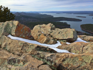
Pinnacle Mountain State Park is a 2,356-acre state park located in Pulaski County, Arkansas just outside of Little Rock. The main attraction is Pinnacle Mountain, an iconic landmark surrounded by the bottomlands of the Big Maumelle and Little Maumelle rivers.

Highway 7 is a north–south state highway that runs across the state of Arkansas. As Arkansas's longest state highway, the route runs 297.27 miles (478.41 km) from Louisiana Highway 558 at the Louisiana state line north to Bull Shoals Lake at Diamond City near the Missouri state line. With the exception of the segment north of Harrison, Highway 7 has been designated as an Arkansas Scenic Byway and a National Forest Scenic Byway. The road passes through the heart of both the Ozark Mountains and the Ouachita Mountains, and features scenic views. It's the route favored by motorcycle riders touring the region.

Arkansas Highway 23 is a north–south state highway in north Arkansas. The route runs 129.88 miles (209.02 km) from US 71 near Elm Park north to the Missouri state line through Ozark and Eureka Springs. Between AR 16 at Brashears and Interstate 40 north of Ozark, Highway 23 winds through the Ozark National Forest and is designated as the Pig Trail Scenic Byway due to its steep hills and hairpin turns. The route has a strong connection with the University of Arkansas Razorbacks, connecting fans in Central Arkansas with the Northwest Arkansas area.

Arkansas Highway 10 is an east–west state highway in West Arkansas. The route runs 135.41 miles (217.92 km) from Oklahoma State Highway 120 near Hackett east to Interstate 30 in Little Rock, the state's capitol. The highway serves both the Fort Smith metropolitan area and the Little Rock – North Little Rock – Conway metropolitan area.
Ouachita National Recreation Trail is a 223-mile (359 km) long, continuous hiking trail through the Ouachita Mountains of Oklahoma and Arkansas. It is the longest backpacking trail in the Ouachita National Forest, spanning 192 miles across its length. Approximately 177 miles of the trail is in Arkansas and 46 miles of the trail is in Oklahoma. The trail is used by hikers, backpackers, hunters, and mountain bikers. It is a non-motorized single track trail open only to foot traffic and partially open to mountain bicycles. Segments opened to mountain bikes are from the western terminus of the Ouachita Trail at Talimena State Park to the Big Cedar trailhead on US Highway 259 at approximately Mile Marker (MM) 30.5 in Oklahoma, and from the Talimena Scenic Drive Trailhead at MM 54.1, east to Highway 7 at mile 160.4, north of Jessieville, Arkansas.
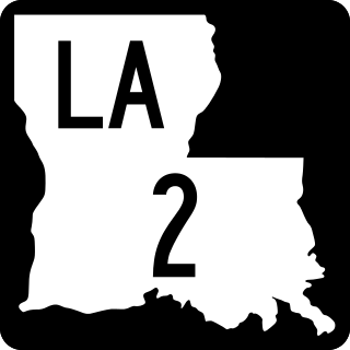
Louisiana Highway 2 (LA 2) is a state highway located in northern Louisiana. It runs 189.49 miles (304.95 km) in an east–west direction from the Texas state line southwest of Vivian to a junction with U.S. Highway 65 (US 65) near Lake Providence, just west of the Mississippi state line.
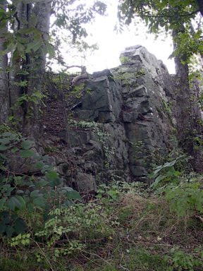
Natural Steps is an unincorporated census-designated place in Pulaski County, Arkansas, United States. It is located 18 miles (29 km) northwest of Little Rock along the southern bank of the Arkansas River, on Arkansas Highway 300. Per the 2020 census, the population was 413. Today, it is a small farming community with scattered businesses. Most of the natural steps, a geologic formation, still stand today and are used as a marker for river runners. The Natural Steps are not open to the public for viewing.

Interstate 40 (I-40) is an east–west Interstate Highway that has a 284.69-mile (458.16 km) section in the U.S. state of Arkansas, connecting Oklahoma to Tennessee. The route enters Arkansas from the west just north of the Arkansas River near Dora. It travels eastward across the northern portion of the state, connecting the cities of Fort Smith, Clarksville, Russellville, Morrilton, Conway, North Little Rock, Forrest City, and West Memphis. I-40 continues into Tennessee, heading through Memphis. The highway has major junctions with I-540 at Van Buren, I-49 at Alma, I-30 in North Little Rock, and I-55 to Blytheville.

The geography of Arkansas varies widely. The state is covered by mountains, river valleys, forests, lakes, and bayous in addition to the cities of Arkansas. Hot Springs National Park features bubbling springs of hot water, formerly sought across the country for their healing properties. Crowley's Ridge is a geological anomaly rising above the surrounding lowlands of the Mississippi embayment.

Highway 28 is designation for three east–west state highways in Western Arkansas. Two segments together running from the Oklahoma state line to Ola have been established since the original 1926 Arkansas state highway numbering, with the third segment designated in 1963. All three highways are rural, two-lane roads with relatively low traffic serving a sparsely populated and forested part of Arkansas. The highways are maintained by the Arkansas Department of Transportation (ARDOT).

Highway 300 is a designation for two state highway segments in Central Arkansas. The main route of 34.11 miles (54.89 km) runs from Highway 9/Highway 10 east to Highway 10 in Little Rock. A second segment runs 1.45 miles (2.33 km) east from Interstate 430 as Colonel Glenn Road.

Arkansas Highway 192 is a designation for two state highways in Garland County, Arkansas. One route of 5.32 miles (8.56 km) runs from US Route 70 (US 70) to Lakeshore Drive near Lake Hamilton. A second routing begins east of Lake Ouachita State Park at Highway 227 and runs northeast to Highway 7 near Hot Springs Village.

Pinnacle Mountain is a 1,011-foot (308 m) summit and the second-highest natural point in Pulaski County, Arkansas, United States; it is also the primary attraction of the 2,356-acre (953 ha) Pinnacle Mountain State Park. Located in the foothills of the Ouachita Mountains approximately 13 miles (21 km) northwest of downtown Little Rock, Arkansas, Pinnacle Mountain is one of the most iconic landforms of the U.S. Interior Highlands.

