
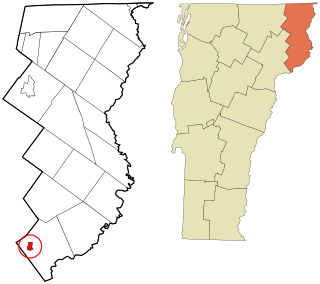
Caledonia County is a county located in the northeastern part of the U.S. state of Vermont. As of the 2020 census, the population was 30,233. Its shire town is the town of St. Johnsbury. The county was created in 1792 and organized in 1796. It was given the Latin name for Scotland, in honor of the many settlers who claimed ancestry there.

Barnet is a town in Caledonia County, Vermont, United States. The population was 1,708 at the 2010 census. Barnet contains the locations of Barnet Center, East Barnet, McIndoe Falls, Mosquitoville, Passumpsic and West Barnet. The main settlement of Barnet is recorded as a census-designated place by the U.S. Census Bureau, with a population of 129 at the 2010 census.

Danville is a town in Caledonia County, Vermont, United States. The population was 2,196 at the 2010 census. The primary settlement in town is recorded as the Danville census-designated place (CDP) and had a population of 383 at the 2010 census.

Lyndon is a town in Caledonia County, Vermont, United States. As of the 2020 census, the population was 5,491. Lyndon is the home of Lyndon State College. The town contains one incorporated village, Lyndonville, and four unincorporated villages: Lyndon Corner in the south, Lyndon Center in the center of town on the west side of Lyndonville, Little Egypt in the north, and East Lyndon in the southeast.

Ryegate is a town in Caledonia County, Vermont, United States. The population was 1,174 at the 2010 census. The town contains the villages of South Ryegate, East Ryegate, and Ryegate Corner.

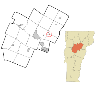
St. Johnsbury is a census-designated place (CDP) corresponding to the main settled areas in the town of St. Johnsbury, Caledonia County, Vermont, United States. As of the 2020 census it had a population of 5,994, out of 7,364 in the entire town.

St. Johnsbury is the shire town of Caledonia County, Vermont, United States. As of the 2020 census, the population was 7,364. St. Johnsbury is situated on the Passumpsic River and is located approximately six miles northwest of the Connecticut River and 48 miles (77 km) south of the Canada–U.S. border.

The Passumpsic River is a 22.7-mile-long (36.5 km) tributary of the Connecticut River, in Vermont. Though primarily a Caledonia County river, it is the only river to flow through all three counties of the Northeast Kingdom.

U.S. Route 5 (US 5) is a part of the United States Numbered Highway System that runs from New Haven, Connecticut to the Canada–United States border at Derby Line, Vermont. In Vermont, the road runs south–north from the Massachusetts state line near Guilford to the international border. The 192.316 miles (309.503 km) that lie in Vermont are maintained by the Vermont Agency of Transportation (VTrans) and run largely parallel to Interstate 91. US 5 also follows the path of the Connecticut River from the Massachusetts border to St. Johnsbury, where the river turns northeast while US 5 continues north. The highway serves the major towns of Brattleboro, Hartford, and St. Johnsbury, along with the city of Newport near the Canadian border.
Plainfield is a census-designated place (CDP) comprising the main village of the town of Plainfield, Washington County, Vermont, United States. The population of the CDP was 401 at the 2010 census.
Barnet is the primary village and a census-designated place (CDP) in the town of Barnet, Caledonia County, Vermont, United States. As of the 2020 census, the CDP had a population of 127, out of 1,663 in the entire town of Barnet.
Danville is the primary village and a census-designated place (CDP) in the town of Danville, Caledonia County, Vermont, United States. As of the 2020 census, the CDP had a population of 385, out of 2,335 in the entire town of Danville.
Groton is the primary village and a census-designated place (CDP) in the town of Groton, Caledonia County, Vermont, United States. As of the 2020 census, the CDP had a population of 419, out of 984 in the entire town of Groton.
Hardwick is the primary village and a census-designated place (CDP) in the town of Hardwick, Caledonia County, Vermont, United States. As of the 2020 census, the CDP had a population of 1,269, out of 2,920 in the entire town of Hardwick.
Concord is a census-designated place comprising the main settlement in the town of Concord, Essex County, Vermont, United States. As of the 2010 census, it had a population of 271, out of a total town population of 1,235.
Randolph is the primary village and a census-designated place (CDP) in the town of Randolph, Orange County, Vermont, United States. As of the 2020 census, it had a population of 2,083, out of 4,774 in the entire town of Randolph.
Peacham is the primary village and a census-designated place (CDP) in the town of Peacham, Caledonia County, Vermont, United States. It was first listed as a CDP prior to the 2020 census. The Peacham Corner Historic District, listed on the National Register of Historic Places, occupies the four roads extending outward from the crossroads at the village center.
Sheffield is the primary village and a census-designated place (CDP) in the town of Sheffield, Caledonia County, Vermont, United States. It was first listed as a CDP prior to the 2020 census.
Sutton is the primary village and a census-designated place (CDP) in the town of Sutton, Caledonia County, Vermont, United States. It was first listed as a CDP prior to the 2020 census.
Castleton Four Corners is a census-designated place (CDP) in the town of Castleton, Rutland County, Vermont, United States. It consists of the unincorporated villages of Castleton Corners and Hydeville. As of the 2020 census, the CDP had a population of 699, out of 4,458 in the entire town.


