
Edwards is an unincorporated town, a post office, and a census-designated place (CDP) located in and governed by Eagle County, Colorado, United States. Edwards is the principal town of the Edwards, CO Micropolitan Statistical Area. The Edwards post office has the ZIP Code 81632. At the United States Census 2010, the population of the Edwards CDP was 10,266, while the population of the 81632 ZIP Code Tabulation Area was 10,267. The Edwards Metropolitan District provides services.

The Air Force Academy is a census-designated place (CDP) located in El Paso County, Colorado, United States. The CDP includes the developed portion of the United States Air Force Academy, including the cadet housing facilities. The CDP is a part of the Colorado Springs, CO Metropolitan Statistical Area. The USAF Academy post office (ZIP Codes 80840 and 80841 serves the area. At the United States Census 2010, the population of the Air Force Academy CDP was 6,680, while the population of the 80840 ZIP Code Tabulation Area was 6,682.

Woodmoor is an unincorporated community and a census-designated place (CDP) located in and governed by El Paso County, Colorado, United States. The CDP is a part of the Colorado Springs, CO Metropolitan Statistical Area. The population of the Woodmoor CDP was 8,741 at the United States Census 2010. The Monument post office serves the area.

Avondale is an unincorporated town, a post office, and a census-designated place (CDP) located in and governed by Pueblo County, Colorado, United States. The CDP is a part of the Pueblo, CO Metropolitan Statistical Area. The Avondale post office has the ZIP Code 81022. At the United States Census 2020, the population of the Avondale CDP was 594, while the population of the 81022 ZIP Code Tabulation Area was 1,624 including adjacent areas.

Security-Widefield is a census-designated place (CDP) comprising the unincorporated communities of Security and Widefield located in and governed by El Paso County, Colorado, United States. The CDP is a part of the Colorado Springs, CO Metropolitan Statistical Area. The population of the Security-Widefield CDP was 32,882 at the United States Census 2010. El Paso County governs the unincorporated communities. Both the Colorado Springs post office and the Fountain post office serve the area.
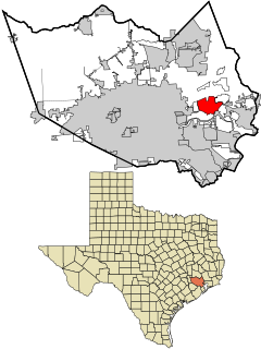
Channelview is a census-designated place (CDP) in the U.S. state of Texas on the eastside of Houston, Harris County. The population was 45,688 at the 2020 U.S. census.

Gardner is an unincorporated town, a post office, and a census-designated place (CDP) located in and governed by Huerfano County, Colorado, United States. The Gardner post office has the ZIP Code 81040. At the United States Census 2010, the population of the 81040 ZIP Code Tabulation Area was 536 including adjacent areas.

Howard is an unincorporated town, a post office, and a census-designated place (CDP) located in and governed by Fremont County, Colorado, United States. The CDP is a part of the Cañon City, CO Micropolitan Statistical Area. The Howard post office has the ZIP Code 81233. At the United States Census 2010, the population of the Howard CDP was 723, while the population of the 81233 ZIP Code Tabulation Area was 823 including adjacent areas.

Weldona is an unincorporated town, a post office, and a census-designated place (CDP) located in and governed by Morgan County, Colorado, United States. The CDP is a part of the Fort Morgan, CO Micropolitan Statistical Area. The Weldona post office has the ZIP Code 80653. At the United States Census 2010, the population of the Weldona CDP was 139, while the population of the 791 ZIP Code Tabulation Area was 4,232 including adjacent areas.

Weston is an unincorporated town, a post office, and a census-designated place (CDP) located in and governed by Las Animas County, Colorado, United States. The Weston post office has the ZIP Code 81091. At the United States Census 2010, the population of the Weston CDP was 55, while the population of the 81091 ZIP Code Tabulation Area was 812 including adjacent areas.

Wolcott is an unincorporated town, a post office, and a census-designated place (CDP) located in and governed by Eagle County, Colorado, United States. The CDP is a part of the Edwards, CO Micropolitan Statistical Area. The Wolcott post office has the ZIP Code 81655. At the United States Census 2010, the population of the Wolcott CDP was 15, while the population of the 81655 ZIP Code Tabulation Area was 65 including adjacent areas.

South Mills is an unincorporated community and census-designated place (CDP) in Camden County, North Carolina, United States. Its population was 454 as of the 2010 census. South Mills has a post office with ZIP code 27976, which opened on March 2, 1840. The community is located near U.S. Route 17, and U.S. Route 17 Business and North Carolina Highway 343 pass through the community.
Box Springs is an unincorporated community and census-designated place (CDP) in Talbot County, Georgia, United States. The community is located in the county's extreme southwestern corner, 12.2 miles (19.6 km) southwest of Talbotton. Box Springs has a post office with ZIP code 31801.
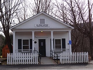
Gilman is an unincorporated community and census-designated place (CDP) in the town of Lunenburg, Essex County, Vermont, United States. It was first listed as a CDP prior to the 2020 census. The community has a post office with ZIP code 05904.
Pierrepont Manor is a hamlet and census-designated place (CDP) in Jefferson County, New York, United States. Its population was 228 as of the 2010 census. Pierrepont Manor has a post office with ZIP code 13674, which opened on November 29, 1843. U.S. Route 11 and New York State Route 193 intersect in the community; it is also served by an exit on Interstate 81.
Livonia Center is a hamlet and census-designated place (CDP) in the town of Livonia, Livingston County, New York, United States. Its population was 421 as of the 2010 census. Livonia Center has a post office with ZIP code 14488, which opened on April 9, 1811.
South Lima is a hamlet and census-designated place (CDP) in Livingston County, New York, United States. Its population was 240 as of the 2010 census. South Lima had a post office from January 10, 1854, until April 17, 2010; it still has its own ZIP code, 14558.

West Dummerston is an unincorporated village and census-designated place (CDP) in the town of Dummerston, Windham County, Vermont, United States. The community is located along Vermont Route 30 and the West River 6 miles (9.7 km) north-northwest of Brattleboro. West Dummerston has a post office with ZIP code 05357.
Underhill Center is an unincorporated village and census-designated place (CDP) in the town of Underhill, Chittenden County, Vermont, United States. The community is 4.9 miles (7.9 km) east of the village of Jericho. Underhill Center has a post office with ZIP code 05490, which opened on December 30, 1850.
North Hyde Park is an unincorporated village and census-designated place (CDP) in the towns of Hyde Park and Johnson, Lamoille County, Vermont, United States. The CDP was first drawn for the 2020 census. North Hyde Park has a post office with ZIP code 05665, which opened on May 29, 1839.


