KwaDukuza, previously known as Stanger, is a city in KwaZulu-Natal, South Africa. In 2006, the municipal name was changed to KwaDukuza, but the Zulu people in the area called it "Dukuza" well before then.
Ballito is an affluent coastal town located in KwaZulu-Natal, South Africa. Ballito is about 40 kilometres (25 mi) north of Durban and 24 kilometres south of KwaDukuza. It forms part of the KwaDukuza Local Municipality, and iLembe District Municipality. Dolphins and Whales are common on this stretch of the North Coast shoreline, hence the nickname Dolphin Coast. The name of the town Ballito is named after the Italian word for "small ball".
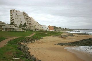
Hibberdene is a small coastal town on the KwaZulu-Natal South Coast in South Africa, approximately 23 km north-east of Port Shepstone and 90 km south-west of Durban and halfway between coastal towns of Scottburgh and Margate.

Mount Edgecombe or Mt Edgecombe is a town in KwaZulu-Natal, South Africa, situated just north of Durban, which forms part of eThekwini, the Greater Durban Metropolitan area. Much of the suburb is cordoned off as a gated settlement comprising resorts, golf courses and a retirement home. It was previously a sugar growing area. The population increased by 89% between 2001 and 2011 from 3,874 to 7,323. Its name is derived from the Earl of Mount Edgecombe in Cornwall, United Kingdom.

oThongathi, previously and still commonly known as Tongaat, is a town in KwaZulu-Natal, South Africa, about 40 kilometres (25 mi) north of Durban and 28 kilometres (17 mi) south of KwaDukuza. It now forms part of eThekwini Metropolitan Municipality, or the Greater Durban area. The area is home to the oldest Indian community in South Africa, having been where the first indentured Indian laborers settled in 1860 to work in the sugar-cane plantations. Much of the architectural style in the town was the work of Ivan Mitford-Barberton, and many buildings are in the Cape Dutch style of architecture.

Verulam is a town 24 kilometres north of Durban in KwaZulu-Natal, South Africa and forms part of the eThekwini Metropolitan Municipality, governing the Greater Durban metropolitan area.

The R102 is a Regional Route in South Africa. It is the route designation for all old sections of the N2, thus it is a discontinuous road that resumes in areas where a new N2 has been constructed.

Umlazi is a township in KwaZulu-Natal, South Africa, located south-west of Durban. Organisationally and administratively it forms part of the eThekwini Metropolitan Municipality and its South Municipal Planning Region.

The N2 is a national route in South Africa that runs from Cape Town through George, Gqeberha, East London, Mthatha, Port Shepstone and Durban to Ermelo. It is the main highway along the Indian Ocean coast of the country. Its current length of 2,255 kilometres (1,401 mi) makes it the longest numbered route in South Africa.

King Shaka International Airport, abbreviated KSIA, pronounced as, is the primary international airport serving Durban, South Africa. It is located in La Mercy, KwaZulu-Natal, approximately 35 km (22 mi) north of the city centre of Durban. The airport opened its doors to passengers on May 1, 2010, 41 days before the start of the 2010 FIFA World Cup. It replaced Durban International Airport and uses the same IATA airport code. The airport was designed by Osmond Lange Architects and Planners and cost R 6,800,000,000.
The M4 is a north–south metropolitan route in the eThekwini Metropolitan Municipality and partially in the KwaDukuza Local Municipality, South Africa. It runs from the N2 at the defunct Durban International Airport to Ballito via the Durban Central Business District (CBD) and uMhlanga. The sections between the airport and the southern edge of the CBD, and between the northern edge of the CBD and the exit to uMhlanga are classified as freeway. On the section from the southern edge of the CBD to the Bram Fischer Street/Soldier's Way junction, the M4 is cosigned with the R102.

Shakaskraal is a town in Ilembe District Municipality in the KwaZulu-Natal province of South Africa. The town is dominated by local businesses and informal traders and main activities located in and nearby is sugar cane farming.

KwaZulu-Natal South Coast is a region along the southern stretch of coastline of KwaZulu-Natal, South Africa, south of the coastal city of Durban.
The KwaZulu-Natal North Coast, better known as the North Coast is a coastal region north of Durban in KwaZulu-Natal, South Africa. It stretches from Zinkwazi Beach in the north to Zimbali near Ballito in the south. The coastal region is governed by the KwaDukuza Local Municipality, forming part of the iLembe District Municipality.
The M5 is a long metropolitan route in the eThekwini Metropolitan Municipality, South Africa. It starts in KwaMashu in the north-western townships of Durban. It passes through the townships of KwaMashu, Newlands East, Newlands West, Ntuzuma and KwaDabeka. It then passes through the industrial town of New Germany and the leafy towns of Pinetown and Queensburgh before entering Durban and ending with the R102 in the Umbilo industrial area.
Mobeni is a suburb of Durban in KwaZulu-Natal, South Africa and forms part of the heavily industrialised South Durban Basin, a sub-region south of Durban.
The M1 is a metropolitan route in the eThekwini Metropolitan Municipality, South Africa, linking Pinetown to Mobeni in Durban via Chatsworth.
The M21 is a metropolitan route in the eThekwini Metropolitan Municipality, South Africa linking Durban with Phoenix via Newlands West and KwaMashu.
The M27 also known as Jabu Ngcobo Drive or Old Inanda Road is a metropolitan route in the eThekwini Metropolitan Municipality, South Africa linking Inanda to Verulam and eMdloti, north of Durban.
Umhlali is a village on the North Coast of the KwaZulu-Natal province of South Africa, just inland from Salt Rock and approximately 50 km north-west of Durban. The name of the village, "Umhlali" derives from the Zulu name of the Monkey Orange tree - a small semi-deciduous tree that is predominant along the banks of the uMhlali River, north of the village.
