| No. | Direction | Description of Route | Suburbs | Street Names | Other |
|---|
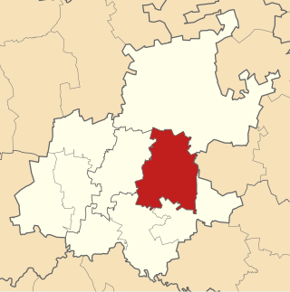
 M1 M1 | North/South then East/West | M13 / M31 (Westmead) – N3 – M34 – M22 – M20 – N2 – R102 (Mobeni West) | Westmead, Ashley, Caversham Glen, Mariannhill, Mariannridge, Intake, Savannah Park, Crossmoor, Moorton, Arena Park, Westcliff, Havenside, Mobeni Heights, Mobeni West | Henry Pennington Rd, Higginson Highway, Grimsby Rd | Part highway |
 M4 M4 | North/South | N2 (Merebank, Start highway) – M7 – M11 – R102 (start cosigned) – N3 – M13 – M15 – R102 (end cosigned) – M12 – M17 (Start highway) – M21 – M41 – M12 – M27 – M43 (End highway) – N2 – R102 (near Shaka's Head) | Merebank, Austerville, Mobeni East, Clairwood, Rossburgh, uMbilo Industrial, Congela, Maydon Wharf, Esplanade, Warwick, Old Fort, Blue Lagoon, Prospect Hall, Broadway, Virginia, Glenashley, La Lucia, uMhlanga Rocks, eMdloti, La Mercy, Desainagar, Tongaat Beach, Genazano, Zimbali, Ballito | Inkosi Albert Luthuli Fwy, West Street / Smith Street, Warwick Avenue / Market Rd (R102), Williams St / leopold St (R102), Old Fort Rd / Ordinance Rd, Prince Alfred St / Stanger Street, Ruth First Fwy, Leo Boyd Hwy, Ballito Dr | Part highway |
 M5 M5 | North/South then East/West | Starts at Kwa-Mashu – M32 – M19 – M31 – M13 – M34 – M7 – M10 – M10 (cosigned) – M7 – R102 (uMbilo) | KwaMashu, Newlands, Ntuzuma, Kwa-Dabeka, Berkshire Downs, Falcon Industrial Park, Cowies Hill Park, Sarnia, Moseley Park, Glen Park, Moseley, Northdene, Escombe, Malvern, Hillary, Bellair, Sea View, Rossburgh, uMbilo | Dinkelman Rd, Otto Volek Rd, Stapleton Rd, Underwood Rd, Main Rd, Sarnia Rd | |
 M7 M7 | East/West | M13 / M19 (Hatton Estate, Start highway) – N3 – M34 – M5 – N2 (end of Highway) – M10 – R102 (start cosign) – M5 – R102 (end cosign) – M4 – M16 (cosigned) – ends at Brighton Beach | Hatton Estate, Farningham Ridge, Moseley Park, Northdene, Escomb, Malvern, Hillary, Carrington Heights, Rossburgh, Sea View, Clairwood, Wentworth, Brighton Beach | M7 Freeway, Solomon Mahlangu Dr, Old Mission Rd, Brighton Rd, Grays Inn Rd | Part highway |
 M8 M8 | North/South | M9 (Glenwood) – M11 – M13 – M15 – M17 (Essenwood) | Glenwood, Bulwer, Musgrave, Essenwood | ZK Matthew's}Rd, Bulwer Rd, Cleaver Rd, Botanic Gardens Rd, cowey Rd | |
 M9 M9 | East/West | M32 / M10 (Wiggins) – M8 – R102 – ends at Congella | Wiggins, Glenwood, Congella | Francisco Rd | |
 M10 M10 | East/West then north–south | M5 (Escombe) – M22 – M20 – M5 (cosigned) – M7 – M9/M32 – M13 (cosigned) – M15 – M17 – M19 (Springfield) | Escombe, Queensmead, Mount Vernon, Hillary, Bellair, uMkumbaan, Wiggins, Cato Crest, Waterval Park, Sparks, Sydenham, Springfield | Stella Rd, Sarnia Rd (M5), Wakesleigh Rd, Vusi Mzemela Rd, jam smuts Hwy (M13), Brickfield Rd, Alpine Rd | |
 M11 M11 | East/West | M8 (Bulwer) – R102 – M4 (Esplanade) | Bulwer, Esplanade | Che Guevara Rd | |
 M12 M12 | North/South | M4 (Old Fort) – M17 – M41 – M4 (uMhlanga Rocks) | Old Fort, Stamford, Blue Lagoon, Prospect Hill, Broadway, Glen Hills, Glen Anil, Sunningdale, Somerset Park, uMhlanga Ridge, uMhlanga Rocks | NMR Ave, Kenneth Kaunda Rd, uMhlanga Rocks Dr | |
 M13 M13 | East/West | N3 (near Assagay, Start highway) – M46 - R103 – M39 – M39 – M1/M31 – M7/M19 – M5 – N3 – M31 – N3 – M32 – M15 (End highway) – N3 – M10 (cosigned) – R102/M4 (Warwick) | Assagay, St Helier, Gillitts, Kloof, Fields Hill, Padfield Park, Manor, Westmead, Ashley, Hatton Estate, Cowies Hill Park, Woodside, Grayleigh, Beverley Hills, Sherwood, Watervall Park, Westridge, Bulwer, Warwick | King Cetshwayo Hwy, King Dinuzulu Rd, Cannongate Rd/Chris Ntuli Rd | Part highway |
 M15 M15 | East/West | R102 / M4 (Warwick) – M8 – M10 – M13 (Sparks) | Warwick, Essenwood, Sydenham, Sparks | Cross St / grey St, Gladys Manzi Rd, John Zikhali Rd, ridge Rd, South Rd, Moses Kotane Rd, Locksley Dr | |
 M16 M16 | Southwest / Northeast | R102 (Montclair) – M7 (cosigned) – ends at Fynnlands | Montclair, Jacobs, Clairwood, Grosvernor, Fynnlands | Bluff Rd | |
 M17 M17 | East/West | M10 (Morningside) – M17 – R102 – M12 – M4 (Old Fort) | Morningside, Windermere, Essenwood, Old Fort | Hendry Rd, Earl Haig Rd, Springfield Rd, Argile Rd | |
 M19 M19 | East/West | M7 / M13 (Hatton Estate, Start highway) – M31 – M32 – M5 – M32 – N2 (End highway) – M10 – R102 (Puritan Hills) | Hatton Estate, Pinetown CBD, Falcon Industrial Park, Atholl Heights, Reservoir Hills, Palmiet, Springfield, Puritan Hills | St Johns Ave, M19 Hwy, Umgeni Rd | Part highway |
 M20 M20 | North/South | M10 (Mount Vernon) – M1 (Bayview) | Mount Vernon, uMhlatuzana, Bayview | Hillary Rd, Chatsworth Main Rd | |
 M21 M21 | North/South then East/West | M25 (Phoenix Industrial) – M45 – N2 – R102 – M4 (Prospect Hill) | Phoenix Industrial, KwaMashu, Siyanda, Newlands West, Steelcastle, Newlands East, Parlock, Springfield Flats, Riverside, Prospect Hil | Malandela Rd, Inanda Rd, Riverside Rd | |
 M22 M22 | North/South | M10 (Queensmead) – M1 (Westcliff) | Queensmead, Kharwastan, Westcliff | Carrick Rd, Erica Ave, Astral Dr | |
 M25 M25 | East/West | Starts in eMachobeni – M27 – M26 - M21 – R102 (cosigned) – N2 (near Avoca Hills) | eMachobeni, Glebe, Congo, Langalibalele, Mshayazafe, Newtown, eZimangweni, eMzomusha, Phoenix Industrial, KwaMashu, Duff's Road | Curnick Ndlovu Hwy | |
 M26 M26 | North/South | R102 (Palmview) – M25 (Phoenix Industrial) | Palmview, Shastri Park, Brookdale, Northcroft, Starwood, Whetstone, Redfern, Phoenix Industrial | Gopalall Hurbans Rd, JG Champion Dr, Phoenix Hwy, Industrial Park Rd | |
 M27 M27 | North/South then East/West | M25 (Congo) – R102 – N2 – M4 – ends in eMdloti | Congo, amaTikwe, Tafula, Goqokazi, eKafuleni, Trenance Park, Dawncrest, Cordoba Gardens, Mountview, Brindhaven, Lotusville, Southridge, Waterloo, eMdloti | Mafukuzela Hwy, Jabu Ngcobo Dr | |
 M29 M29 | North/South then East/West | M5 (Sea View) – R102 (Mobeni) | Sea View, Coedmore, Yellowwood Park, Woodlands, Mobeni | Coedmore Rd, Kenyon Howden Rd | |
 M30 M30 | East/West | R603 (near uMbumbulu) – M35 – R102 (uMlazi) | uMbumbulu, uMlazi | Griffiths Mxenge Hwy | |
 M31 M31 | East/West | M1 / M13 (Westmead) – M19 – M32 – M5 – M13 (Cowies Hill Park) | Westmead, Pinetown CBD, Cowies Hill Park | Josiah Gumede Rd | |
 M32 M32 | East/West | M31 (Pinetown CBD) – M19 – M39 – M5 – M19 – M13 – N3 – M10/M9 (Wiggins) | Pinetown CBD, Pineside, The Wolds, Clermont, Atholl Heights, Grayleigh, Beverley Heights, Blackhurst, Wiggins, University of KwaZulu-Natal, Glenwood, Congella, Maydon Wharf | Beviss Rd, Qashana Khuzwayo Rd, Roger Sishi Rd, Jan Hofmeyr Rd, St James Ave, Harry Gwala Rd, Rick Turner Rd | |
 M33 M33 | East/West | R103 (Hillcrest) – M39 – M39 (Kloof CBD) | Hillcrest, Belvedere, Waterfall, Forest Hills, Everton, Kloof CBD | iNanda Rd, Link Rd, Bridle Rd, Kloof Falls Rd, Church Rd, Old Main Rd | |
 M34 M34 | North/South | M5 (Moseley Park) – M7 – M1 (Savannah Park) | Moseley Park, Highlands Hills, Nirvana Hills, Shallcross, Savannah Park | Hans Dettman Hwy | |
 M35 M35 | East/West | R603 (near Folweni) – N2 – M30 (uMlazi) | Folweni, Malukazi, Lotus Park, Isipingo Hills, Isipingo Rail, uMlazi | Sbu Magwanyane Dr, Wanda Cele Rd | |
 M37 M37 | East/West | R603 (near Adams Mission) – N2 – R102 (Amanzimtoti) | Adams Mission, Adams Rural, Malagazi, Amanzimtoti | Moss Kolnik Dr | |
 M39 M39 | East/West | M33 (Kloof CBD) – M13 – M13 – M33 – M32 (The Wolds) | Adams Mission, Adams Rural, Malagazi, Amanzimtoti | Moss Kolnik Dr | |
 M41 M41 | East/West | M4 (La Lucia) – M12 – N2 – R102 (Mt Edgecombe) | La Lucia, uMhlanga Ridge, Cornubia, Mt Edgecombe | M41 | |
 M43 M43 | East/West | R102 (oThongathi) – N2 – M4 (Westbrook) | oThongathi, Westbrook | uShukela Dr (Watson Highway) | |
 M45 M45 | North/South | R102 (Parkhill) – N2 – M21 (KwaMashu) | Parkhill, Kenville, Melkhoute, KwaMashu | Queen Nandi Dr | |
 M46 M46 | North/South | N3 (near Assagay) – M59 - M13 – R103 (Assagay) | Assagay, Hillcrest | Kassier Rd | |
 M47 M47 | North/South | Herrwood Dr (uMhlanga Ridge) – N2 - Umganu Rd (Cornubia) | uMhlanga Ridge, Cornubia | uMhlanga Ridge Blvd | |
 M59 M59 | East/West | Starts in Outer West Durban – M46 (near Hillcrest) | | Cliffdale Rd | |
 M65 M65 | East/West | R102 (near Nyaninga) – N2 (near La Mercy) | | Dube Blvd | |
|