
Bighorn Canyon National Recreation Area is a national recreation area established by an act of Congress on October 15, 1966, following the construction of the Yellowtail Dam by the Bureau of Reclamation. It is one of over 420 sites managed by the U.S. National Park Service. The recreation area spans 120,296.22 acres, straddling the border between Wyoming and Montana. It is divided into two distinct areas, the North District accessed via Fort Smith, Montana and the South District accessed through Lovell, Wyoming. There is no thru road inside the recreation area connecting the two districts. The Yellowtail Dam is located in the North District. It is named after the famous Crow leader Robert Yellowtail, harnesses the waters of the Bighorn River by turning that variable watercourse into Bighorn Lake. The lake extends 71 miles (114 km) through Wyoming and Montana, 55 miles (89 km) of which lie within the national recreation area. The lake provides recreational boating, fishing, water skiing, kayaking, and birding opportunities to visitors. About one third of the park unit is located on the Crow Indian Reservation. Nearly one-quarter of the Pryor Mountains Wild Horse Range lies within the Bighorn Canyon National Recreation Area.

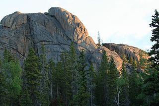
The Bighorn Mountains are a mountain range in northern Wyoming and southern Montana in the United States, forming a northwest-trending spur from the Rocky Mountains extending approximately 200 mi (320 km) northward on the Great Plains. They are separated from the Absaroka Range, which lie on the main branch of the Rockies to the west, by the Bighorn Basin. Much of the land is contained within the Bighorn National Forest.
The Bighorn National Forest is a U.S. National Forest located in northern Wyoming, United States and consists of over 1.1 million acres (4,500 km2). Created as a US Forest Reserve in 1897, it is one of the oldest government-protected forest lands in the U.S. The forest is well east of the continental divide and extends from the Montana border for a distance of 80 miles (130 km) along the spine of the Bighorn Mountains, an outlying mountain range separated from the rest of the Rocky Mountains by Bighorn Basin. Elevations range from 5,000 feet (1,500 m) along the sagebrush and grass-covered lowlands at the foot of the mountains, to 13,189 feet (4,020 m) on top of Cloud Peak, the highest point in the Bighorn Mountains. Around 99% of the land is above 1,500 metres (4,900 ft). The forest is named after the Bighorn River, which is partially fed by streams found in the forest. Streams in the range are fed primarily by snowmelt and snowmelt mixed with driving rainfall.

The Santa Monica Mountains National Recreation Area is a United States national recreation area containing many individual parks and open space preserves, located primarily in the Santa Monica Mountains of Southern California. The SMMNRA is in the greater Los Angeles region, with two thirds of the parklands in northwest Los Angeles County, and the remaining third, including a Simi Hills extension, in southeastern Ventura County.
Fort C. F. Smith was a military post established in the Powder River country by the United States Army in Montana Territory on August 12, 1866, during Red Cloud's War. Established by order of Col. Henry B. Carrington, it was one of five forts proposed to protect the Bozeman Trail against the Oglala Lakota (Sioux), who saw the trail as a violation of the 1851 Treaty of Fort Laramie. The fort was abandoned in 1868 and burned by the Sioux under Red Cloud.
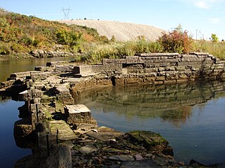
The Bighorn Ditch Headgate, also known as the Bighorn Canal Headgate, was built starting in 1892 to provide irrigation to the Crow Indian Reservation in south central Montana. The headgate structure diverted water from the Bighorn River to their lands. It was designed by William F. Graves, and construction was carried out by Crow workers. The project was completed in 1904. Today the site is included in Bighorn Canyon National Recreation Area.

This is a list of the National Register of Historic Places listings in Big Horn County, Wyoming.

The Ainsworth House, also known as the Greet Ranch, was built in 1886 by homesteader Frank S. Ainsworth and his wife in Big Trails, Wyoming, in the Nowood Valley of Washakie County. The Ainsworths built the frame house after living in a tent and a log dugout. The house was one of the first permanent habitations to be built in the Bighorn Basin.
The Rock Creek Roadless Area (B032) is located northwest of Buffalo, Wyoming, in the Bighorn National Forest. It comprises roughly 34,000 acres (140 km2) of forested timberlands, mountain parks, rugged canyons, and stunning rock formations. This area represents the entire spectrum of environments found in the Bighorn National Forest and encompasses prairie land to high alpine peaks. This roadless area is the source of the north, middle, and south forks of Rock Creek, Balm of Gilead Creek, Pheasant Creek, and Ditch Creek. The area is flanked on the eastern side by the Bud Love Big Game Winter Range and the HF Bar Ranch Historic District. On the southern side the roadless area is surrounded by the Paradise Guest Ranch. The roadless area is home to elk, moose, mountain lion, pine marten, blue grouse, ruffed grouse, and raptors. The Rock Creek area is the largest area of quality elk security habitat outside of the Cloud Peak Wilderness Area and would provide an important corridor from the high country to the Bud Love Habitat Management Unit. The Rock Creek roadless area is dominated by lodgepole pine, some ponderosa, and aspen stands with low-growing juniper in the undergrowth. The area has not been opened to roads due to the ruggedness of the landscape and the high costs of implementation.

The Worland Ranch is a historic district that includes the farmstead established in 1900 by C.F. "Dad" Worland near his namesake town of Worland, Wyoming, United States. The site was in fact the original townsite, with the Worland post office located on the grounds. The present town developed just to the east on the broad flatlands east of the Bighorn River. The original townsite is commemorated by an inscribed stone marker.

The historical buildings and structures of Grand Teton National Park include a variety of buildings and built remains that pre-date the establishment of Grand Teton National Park, together with facilities built by the National Park Service to serve park visitors. Many of these places and structures have been placed on the National Register of Historic Places. The pre-Park Service structures include homestead cabins from the earliest settlement of Jackson Hole, working ranches that once covered the valley floor, and dude ranches or guest ranches that catered to the tourist trade that grew up in the 1920s and 1930s, before the park was expanded to encompass nearly all of Jackson Hole. Many of these were incorporated into the park to serve as Park Service personnel housing, or were razed to restore the landscape to a natural appearance. Others continued to function as inholdings under a life estate in which their former owners could continue to use and occupy the property until their death. Other buildings, built in the mountains after the initial establishment of the park in 1929, or in the valley after the park was expanded in 1950, were built by the Park Service to serve park visitors, frequently employing the National Park Service Rustic style of design.
The Raynolds Expedition was a United States Army exploring and mapping expedition intended to map the unexplored territory between Fort Pierre, Dakota Territory and the headwaters of the Yellowstone River. The expedition was led by topographical engineer Captain William F. Raynolds.
This is a list of the National Register of Historic Places listings in Bighorn Canyon National Recreation Area.

Caroline Cameron Lockhart (1871–1962) was an American journalist and writer.
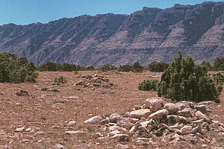
The Bad Pass Trail, also known as the Sioux Trail, was established by Native Americans on the border of present-day Montana and Wyoming as a means of access from the Bighorn Basin in Wyoming to Bison-hunting grounds in the Grapevine Creek area of Montana. Marked by stone cairns, the trail led across Bad Pass and was established in pre-Columbian times. After Europeans arrived in the area it was frequented by fur trappers and mountain men, beginning in 1824. Trappers assembled pack trains at the junction of the Shoshone River and the Bighorn River, using the Bad Pass Trail to avoid Bighorn Canyon. The trail ended at the mouth of Grapevine Creek on the Bighorn, from which the pack train could float down the Bighorn on rafts to the Yellowstone River and then to the Missouri and on to St. Louis.

The Ewing-Snell Ranch was established between 1896 and 1898 by Erastus Ewing in Carbon County, Montana, on Layout Creek between Bighorn Canyon and the Pryor Mountains in a region called Dryhead Country. Ewing took up ranching after failing as a gold miner.
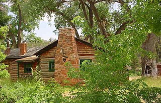
The Caroline Lockhart Ranch was established in 1926 by Caroline Lockhart, who purchased a 160-acre (65 ha) homestead near Davis Creek at the foot of the Pryor Mountains in Carbon County, Montana, while in her fifties. Lockhart expanded the ranch, adding buildings, land and grazing rights until the ranch comprised about 7,000 acres (2,800 ha). The region, known as Dryhead Country, is one of the most isolated places in Montana.
Dryhead Country is a region in Carbon County and Big Horn County in southern Montana between Bighorn Canyon and the Pryor Mountains. The locale was named after the piles of dry bison skulls that accumulated at the base of a local buffalo jump. The Dryhead region starts near the Wyoming border in Bighorn Canyon National Recreation Area and extends northward into the Crow Indian Reservation. Dryhead Creek drains a portion of the area, falling eastwards into Bighorn Canyon. The semi-arid basin is one of the most remote areas in Montana. The area is sparsely populated with isolated ranches.

Cedarvale, also known as Hillsboro Ranch, was a dude ranch and working ranch in Carbon County, southern Montana, United States. The ranch was established about 1903 by prospector Grosvener W. Barry on the South Fork Trail Creek. Barry used the ranch as a home for his family and as a base for his mining ventures, all of which failed. His most lucrative venture was the conversion of Cedarvale from a working ranch to a dude ranch, marketed through an arrangement with the Chicago, Burlington and Quincy Railroad. It was the first dude ranch in the area. Barry introduced powered boats to the Bighorn River to carry dudes to the ranch from the railhead at Kane, Wyoming. As a publicity stunt Barry, his stepson and a neighbor piloted the 16-foot (4.9 m) motorized Edith from the Hillsboro landing down the Bighorn, Yellowstone, Missouri and Mississippi rivers, leaving on May 31, 1913 and arriving in New Orleans on August 1. One of Barry's boats, the Hillmont, is on display at Barry's Landing.
The Jelm-Frank Smith Ranch Historic District, also known as Old Jelm and Cummins City, comprises an area of bottomland on the Laramie River near Woods Landing, Wyoming where the mining boomtown of Cummins City, Wyoming was established in 1880. Gold had been discovered in the nearby mountains and the town was established by W.S. "Buck" Bramel and John Cummins. In 1881 Cummins City was described as having about 100 houses and a hotel. By this time the camp was already declining, and by 1886 mining in the district was largely inactive. However, in the 1890s copper was discovered in the Sierra Madre and Medicine Bow ranges. Cummins City was revived as Jelm in 1900. This boom also declined and in 1930 Jelm's population was 50.


