The Metropolitan Transit Authority of Harris County is a major public transportation agency based in Houston, Texas, United States. It operates bus, light rail, bus rapid transit, HOV and HOT lanes, and paratransit service in the city as well as most of Harris County. It also operates bus service to two cities in Fort Bend County, and to Conroe in Montgomery County. The Metro headquarters are in the Lee P. Brown Administration Building in Downtown Houston. In 2023, the system had a ridership of 77,189,800, or about 232,800 per weekday as of the fourth quarter of 2023.

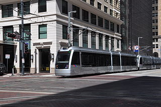
METRORail is the 22.7-mile (36.5 km) light rail system in Houston, Texas. In 2023, the system had a ridership of 13,883,700, or about 42,900 per weekday as of the fourth quarter of 2023. METRORail ranks as the second most-traveled light rail system in the Southern United States and the 12th most-traveled light rail system in the United States, and has the highest ridership per mile for light rail systems in the Southern US. METRORail is operated by the Metropolitan Transit Authority of Harris County (METRO).

Braddock Road station is an island-platformed Washington Metro station in Alexandria, Virginia, United States. The station was opened on December 17, 1983, and is operated by the Washington Metropolitan Area Transit Authority (WMATA). Providing service for both the Blue and Yellow Lines, the station is located at Braddock Road and West Street.

College Park–University of Maryland station is a Washington Metro station in Prince George's County, Maryland, on the Green Line. It also serves MARC's Camden Line, though only select trains stop at the station.

Downtown Transit Center (Houston) is a bus and light rail transportation center in Downtown Houston, Texas, United States, operated by the Metropolitan Transit Authority of Harris County, Texas (METRO). It includes an island platformed METRORail light rail station and bays for bus service.
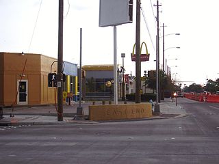
Eastwood is a historic neighborhood in the East End area of Houston, Texas, United States. Eastwood maintains Houston’s largest intact collection of Craftsman, Arts & Crafts, Foursquare and Mission style architecture.
Pecan Park is a neighborhood in Houston, Texas.
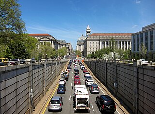
Washington, D.C. has a number of different modes of transportation available for use. Commuters have a major influence on travel patterns, with only 28% of people employed in Washington, D.C. commuting from within the city, whereas 33.5% commute from the nearby Maryland suburbs, 22.7% from Northern Virginia, and the rest from Washington, D.C.'s outlying suburbs.
This is a documentation of the routes, highways, parking requirements, or anything related to transportation in Houston.

Magnolia Park is an area of the East End, Houston, Texas, located near the Houston Ship Channel. One of the oldest Hispanic neighborhoods in the City of Houston, Magnolia Park was formerly incorporated as the City of Magnolia Park in eastern Harris County.
East End Houston, managed by the East End District (EED), is a district in eastern Houston, Texas, United States, located between the eastern edge of downtown to the Port of Houston and South to Hobby Airport. The District is home to Houston's early history and industry and is the site of Harrisburg, the seat of government for the Republic of Texas in 1836. East End Houston consists of many different ethnic groups, including Hispanic, Asian, White, and African American. Latinos make up more than half of the 100,512 residents, The area includes two of Houston's oldest Hispanic neighborhoods, Magnolia Park and Second Ward.

The Texas Department of Transportation (TxDOT) is a governmental agency and its purpose is to "provide safe, effective, and efficient movement of people and goods" throughout the state. Though the public face of the agency is generally associated with maintenance of the state's immense highway system, the agency is also responsible for aviation in the state and overseeing public transportation systems.
The University Line is a planned 25 mi (40 km) bus rapid transit route that would be operated by Metro in Houston, Texas, United States. It replaces a former METRORail light rail line that was proposed in the 2000s and 2010s. The University Line is scheduled to begin construction in 2025 and would be built in five sections between Westchase Park and Ride, Uptown, the University of Houston, and Tidwell Transit Center.
The Red Line is one of three light rail routes on the METRORail network operated by METRO in Houston, Texas. It is the oldest line in the METRORail system, with the first 7.5-mile (12.1 km) section of the line between Fannin South and UH–Downtown opening on January 1, 2004.
The Purple Line is a 6.6-mile (10.6 km) METRORail light rail/streetcar route operated by METRO in Houston, Texas, United States, serving Southeast Houston. The line opened on May 23, 2015.
The Green Line is a 3.3 mi (5.3 km) METRORail light rail/streetcar line operated by METRO in Houston, Texas, serving the East End area. The first seven-station segment of this line opened on May 23, 2015. The two-station eastern end of this route was delayed due to issues over crossing Union Pacific Railroad tracks, but eventually opened in January 2017.

Houston BCycle is a bicycle sharing system, owned and operated by Houston Bike Share, a non-profit organization that administers bike sharing for the City of Houston. There are currently over 150 stations located within the city limits, and over 1300 bicycles.
Altic/Howard Hughes is a light rail station in Houston, Texas, on the METRORail system. It is served by the Green Line and is located on Harrisburg Boulevard at Altic Street in the East End. The station is named for Altic Street as well as Howard Hughes, who built a Hughes Tool Company factory in the area.
Cesar Chavez/67th Street is a light rail station in Houston, Texas on the METRORail system. It is served by the Green Line and is located on Harrisburg Boulevard at South Cesar Chavez Boulevard in the East End.