Related Research Articles
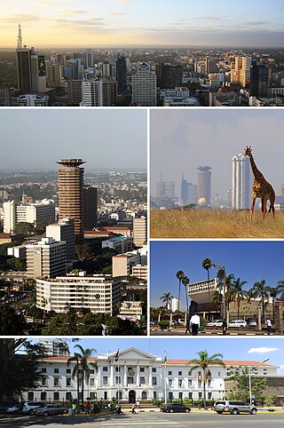
Nairobi is the capital and largest city of Kenya. The name is derived from the Maasai phrase Enkare Nairobi, which translates to 'place of cool waters', a reference to the Nairobi River which flows through the city. The city proper had a population of 4,397,073 in the 2019 census. The city is commonly referred to as The Green City in the Sun.
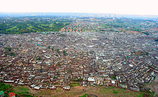
Kibera is a division of Nairobi Area, Kenya, and neighbourhood of the city of Nairobi, 6.6 kilometres (4.1 mi) from the city centre. Kibera is the largest slum in Nairobi, and the largest urban slum in Africa. The 2009 Kenya Population and Housing Census reports Kibera's population as 170,070, contrary to previous estimates of one or two million people. Other sources suggest the total Kibera population may be 500,000 to well over 1,000,000 depending on which slums are included in defining Kibera.

Westlands is a mixed-use neighbourhood in Upper Parklands in Nairobi. Located 3.0 kilometres (2 mi) from Nairobi's central business district, it sits on the westerly areas of the larger Parklands area of Nairobi.

Eastleigh is a mixed-use neighbourhood in Nairobi, Kenya. It is located east of the central business district. It is known for its business prowess as well as "its poor infrastructure.

Embakasi is a neighbourhood in the city of Nairobi. It is approximately 18 kilometres (11 mi), southeast of the central business district. Embakasi is considered part of Nairobi's Eastlands area, lying to the south-east of Nairobi County. The Embakasi proper covers other estates in Eastlands such as Donholm, Pipeline, Tena, and Makadara estates. It borders South C and contains South B and slightly more than one third of Nairobi's Industrial Area and Export Processing Zones.
Kamukunji Constituency is an electoral constituency in Kenya. It is one of seventeen constituencies of Nairobi County. It consists of central to eastern areas of Nairobi. Kamukunji constituency had common boundaries with Pumwani Division of Nairobi. The entire constituency is located within Nairobi City County area. The constituency has an area of 8.80 km2 (3.4 sq mi). The constituency forms part of what was known as Nairobi Central Constituency at the 1963 elections. Kamukunji Constituency was conceived prior to the 1969 elections. The current constituency boundaries were revised prior to the 2013 elections. It borders Starehe Constituency to the west, Makadara to the south, Embakasi West Constituency to the east, and Mathare Constituency to the north.

Korogocho is one of the largest slum neighbourhoods of Nairobi, Kenya. Home to 150,000 to 200,000 people pressed into 1.5 square kilometres, northeast of the city centre, Korogocho was founded as a shanty town on the then outskirts of the city.
Bahati is an estate in Nairobi, the capital of Kenya.
Pumwani is an estate of Nairobi. It is one of the oldest estates in Nairobi's eastlands. In 2019 it had an estimated population of 42,461, a population density of 34,767/km2. Pumwani contains other neighbourhoods such as Magorofani, Shauri Moyo, Majengo, Bondeni and Maziwa.
Laini Saba is a slum of Nairobi, the capital of Kenya. It belongs to the major slum of Kibera. As for Lindi, another village within Kibera, its population is estimated at 100,000. Soweto East is another village belonging to Kibera. The price of water there clearly is above Nairobi average. A Laini Saba Primary School exists.
Lindi is a suburb of Nairobi, the capital of Kenya. It belongs to the major slum of Kibera. As for Laini Saba, another village within Kibera, its population is estimated at 100,000. Soweto East is another village belonging to Kibera. The price of water there clearly is above Nairobi average. A Lindi Friends Primary School exists.

Githurai is a composition of densely populated, urban, mixed-use settlements located at the border of Nairobi County and Kiambu County along the Thika Road. Githurai is divided into two; Githurai 45 and Githurai 44. Githurai 45 falls under Ruiru Constituency in the Githurai Sub-county of Kiambu County with the boundary being the Thika Road reserve and River Kasarani downstream. Githurai 44 is domiciled in Roysambu Constituency in the Kasarani Sub-county of Nairobi County. Githurai 44 neighbours Kahawa West, Zimmerman and Njatha-ini Village.

Mukuru is a collection of slums in the city of Nairobi. It is approximately 7 kilometres (4.3 mi) south of the central business district of Nairobi. It is one of the largest slums in Nairobi. It stretches along the Nairobi–Ngong River, situated on waste lands in the industrial area of the city between the Outering Ring Road, North Airport Road and Mombasa Road. Mukuru is among other major slums in Nairobi such: Korogocho, Kibera and Mathare.
Pipeline is a slum-like neighbourhood in Embakasi in the city of Nairobi. Located within the larger Eastlands area of Nairobi, it is approximately 9.5 kilometres (5.9 mi) east of the central business district. It has earned a reputation for its poor infrastructure, coupled with overcrowded flats, narrow streets, littering, as well as its poor drainage system.
Shauri Moyo is a low-income neighbourhood in Pumwani in the city of Nairobi. It is approximately 3 kilometres (1.9 mi) southeast of the central business district of Nairobi. It is one of the oldest estates in Nairobi.
Starehe is a neighbourhood in the city of Nairobi. It is approximately 2.6 kilometres (1.6 mi) east of the central business district of Nairobi. It is one of the oldest estates in Nairobi.
Kware is a slum neighbourhood in Embakasi in the city of Nairobi. Located within the larger Eastlands area of Nairobi, it is approximately 9 kilometres (5.6 mi) east of the central business district. It borders the Mukuru slums and Initially Kware was predominantly an informal settlement but over the years part Kware and Pipeline have earned a reputation for their poor infrastructure, coupled with overcrowded flats, narrow streets, littering, as well as its poor drainage system.
References
- ↑ http://www.ris.org.in/Nairobi_Case.pdf%5B%5D
- ↑ White, L. (1990). The Comforts of Home: Prostitution in Colonial Nairobi. University of Chicago Press. p. 86. ISBN 9780226895062 . Retrieved 2015-03-27.
- ↑ "Hope for Aids cure as prostitutes defy virus in the slums | World news | The Guardian". guardian.co.uk. Retrieved 2015-03-27.
 | |||||
| Neighbourhoods |
| ||||
| County Divisions | |||||
| Transport | |||||
| Education |
| ||||
| Landmarks | |||||