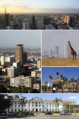
Nairobi is the capital and largest city of Kenya. The name is derived from the Maasai phrase Enkare Nairobi, which translates to 'place of cool waters', a reference to the Nairobi River which flows through the city. The city proper had a population of 4,397,073 in the 2019 census. The city is commonly referred to as The Green City in the Sun.

Westlands is a mixed-use neighbourhood in Upper Parklands in Nairobi. Located 3.0 kilometres (2 mi) from Nairobi's central business district, it sits on the westerly areas of the larger Parklands area of Nairobi.
Highridge is a residential estate in Nairobi, located in northern parts of the larger Parklands estate. Administratively, Highridge is a subdivision of the Westlands division of Nairobi.
Ngara Girls' High School is a girls' secondary boarding school in Nairobi, Kenya.
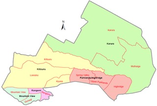
Westlands is an electoral constituency in Kenya. It is one of the seventeen constituencies in Nairobi County. The constituency is situated within Westlands Sub-county, formerly Westlands District. The entire constituency is located within Nairobi City County. The constituency has an area of 72.4 km2 (28.0 sq mi). It was known as Nairobi Northwest Constituency at the 1963 elections, then as Parklands Constituency and since 1988 elections it has been known as Westlands Constituency.
Kilimani is a mixed-use commercial and residential neighbourhood in the city of Nairobi.
South B is the name of a Division of the sub-county of Starehe in Nairobi, Kenya and the name of a "sub-location" of Mukuru Nyayo within the Division. The 2019 Kenya Census gives a population of 102,441 for South B Division and 34,216 for the sub-location. South B is about 3 kilometres (1.9 mi) south-east of Nairobi Central Business District; the Industrial Area lies to the east and the South C district to the south-west.

Chase Bank Kenya Limited(CBK), commonly referred to as Chase Bank, was a commercial bank in Kenya, licensed by the Central Bank of Kenya, the central bank and national banking regulator.
Imperial Bank Limited commonly known as Imperial Bank, is a commercial bank in Kenya, the largest economy in the East African Community. It is one of the forty-three commercial banks licensed by the Central Bank of Kenya, the central bank and national banking regulator.

Upper Hill is a neighbourhood of the city of Nairobi, the capital and largest city of Kenya. The district has seen an increase in major construction in recent years, with several multinational corporations setting up offices.
Kitisuru is a residential suburb of Nairobi. The name Kitisuru comes from a nearby river "Gĩtathuru" which was borrowed from the original inhabitants of the area who were mainly of the Kikuyu ethnic group. Kitisuru forms part of Kitisuru Ward, an electoral division within Nairobi City County.

Kasarani is a commercial and residential neighbourhood in northeast Nairobi. Kasarani is also used in reference to the city's second most populated sub-county with the same name, which spans through neighbourhoods in the northeastern areas of Nairobi. Located within the larger Kasarani area, the Kasarani enclave is approximately 11 kilometres (7 mi) northeast of Nairobi's central business district off Thika Road.
The real estate sector in Kenya has seen a boom that began somewhere in the mid to late 2000s because the property market is responding to increased demand.
Pangani, Nairobi is a suburb of Nairobi. It is one of the oldest estates in Nairobi, and is located approximately 4 kilometres (2.5 mi), by road, northeast of Nairobi's central business district.
Kileleshwa is a residential neighbourhood in the city of Nairobi. It is located approximately 5.2 kilometres (3 mi) from Nairobi's central business district. The neighbourhood was originally a low-density leafy suburb but after change in zoning regulations in the early 2000s, there has been significant mushrooming of high-rise flats in the area. It hosts mainly the upper middle class segment of the Nairobi residents.
Ngara is a commercial and residential suburb of Nairobi. Located within the larger Starehe Sub-county, it is approximately 1.7 kilometres (1.1 mi) northeast of Nairobi's central business district along Muranga Road.
Hurlingham is a commercial and residential neighbourhood in the city of Nairobi. It is approximately 2.5 kilometres (1.6 mi) west of the central business district.
Loresho is an affluent neighbourhood in the city of Nairobi. It is approximately 7.5 kilometres (4.7 mi) northwest of the central business district of Nairobi.
Kyuna is an affluent neighbourhood in the city of Nairobi. It is approximately 6.4 kilometres (4.0 mi) northwest of the central business district of Nairobi.
Mountain View is a neighbourhood in the city of Nairobi. It is approximately 9 kilometres (5.6 mi) west of the central business district of Nairobi.

