Manassas, Georgia

Last updated

Manassas, Georgia
Tattnall County Georgia Incorporated and Unincorporated areas Manassas Highlighted.svg
Location in Tattnall County and the state of Georgia
Coordinates: 32°9′51″N82°1′17″W / 32.16417°N 82.02139°W / 32.16417; -82.02139
Country United States
State Georgia
County Tattnall
Area
[1]
  Total0.78 sq mi (2.01 km2)
  Land0.77 sq mi (2.00 km2)
  Water0.00 sq mi (0.01 km2)
Elevation
210 ft (64 m)
Population
 (2020)
  Total59
  Density76.33/sq mi (29.48/km2)
Time zone UTC-5 (Eastern (EST))
  Summer (DST) UTC-4 (EDT)
ZIP code
30438
Area code 912
FIPS code 13-49504 [2]
GNIS feature ID0332310 [3]

Manassas is a city in Tattnall County, Georgia, United States. Per the 2020 census, the population was 59. [4]

Contents

History

The community was named after Manassas Foy, the son of a local citizen. [5] The Georgia General Assembly incorporated Manassas as a city in 1920. [6]

Geography

Manassas is located at 32°9′51″N82°1′17″W / 32.16417°N 82.02139°W / 32.16417; -82.02139 (32.164091, -82.021337). [7]

According to the United States Census Bureau, the city has a total area of 0.8 square miles (2.1 km2), all of it land.

Demographics

Historical population
CensusPop.Note
1930 197
1940 165−16.2%
1950 128−22.4%
1960 15420.3%
1970 144−6.5%
1980 116−19.4%
1990 1236.0%
2000 100−18.7%
2010 94−6.0%
2020 59−37.2%
U.S. Decennial Census [8]
2010 [9] 2020 [10]
Manassas city, Georgia – Demographic Profile
(NH = Non-Hispanic)
Race / EthnicityPop 2010 [9] Pop 2020 [10] % 2010% 2020
White alone (NH)463648.94%61.02%
Black or African American alone (NH)362338.30%38.98%
Native American or Alaska Native alone (NH)000.00%0.00%
Asian alone (NH)000.00%0.00%
Pacific Islander alone (NH)000.00%0.00%
Some Other Race alone (NH)000.00%0.00%
Mixed Race/Multi-Racial (NH)101.06%0.00%
Hispanic or Latino (any race)11011.70%0.00%
Total9459100.00%100.00%

In 2020, its population was 59, down from 94 in 2010 and 100 in 2000.

Related Research Articles

<span class="mw-page-title-main">Manassas Park, Virginia</span> Independent city in Virginia, United States

Manassas Park is an independent city in the U.S. state of Virginia. As of the 2020 census, the population was 17,219. Manassas Park is bordered by the city of Manassas and Prince William County. Manassas Park is a part of the Washington-Arlington-Alexandria, DC-VA-MD-WV Metropolitan Statistical Area.

<span class="mw-page-title-main">Midville, Georgia</span> City in Georgia, United States

Midville is a city in Burke County, Georgia, United States. The population was 269 at the 2010 census. It is part of the Augusta, Georgia metropolitan area.

<span class="mw-page-title-main">Edison, Georgia</span> City in Georgia, United States

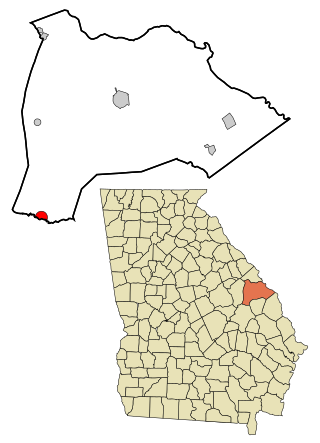
Edison is a city in Calhoun County, Georgia, United States. Per the 2020 census, the population was 1,230. The Edison Commercial Historic District is listed on the National Register of Historic Places.

<span class="mw-page-title-main">Broxton, Georgia</span> City in Georgia, United States

Broxton is a city in Coffee County, Georgia, United States. Per the 2020 census, the population was 1,060. It is known for its unique sandstone formation called Broxton Rocks along Rocky Creek 10 miles (16 km) north of town.

<span class="mw-page-title-main">Bartow, Georgia</span> Town in Georgia, United States

Bartow is a town in Jefferson County, Georgia, United States. As of the 2020 census, the city had a population of 186. Initially the town was known as "Spier's Turnout", but was changed to honor the first Confederate officer to die in battle, Colonel Francis S. Bartow of Savannah, Georgia, who was killed at the Battle of Manassas, Virginia on July 21, 1861.

<span class="mw-page-title-main">Wrightsville, Georgia</span> City in Georgia, United States

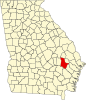
Wrightsville is a city in and the county seat of Johnson County, Georgia, United States. The population was 2,195 at the 2010 census, down from 2,223 at the 2000 census. By 2020, its population grew to 3,449. The city limits include Johnson State Prison on the northeast side of town. Wrightsville is part of the Dublin Micropolitan Statistical Area.

<span class="mw-page-title-main">Culloden, Georgia</span> City in Georgia, United States

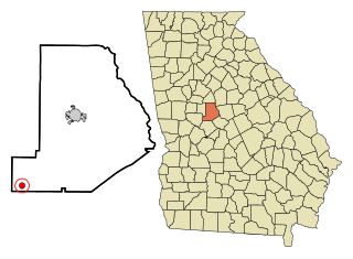
Culloden is a city in Monroe County, Georgia, United States. The population was 200 in the 2020 census. It is part of the Macon Metropolitan Statistical Area.

<span class="mw-page-title-main">Crawfordville, Georgia</span> Town in Georgia, United States

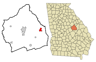
Crawfordville is a town in Taliaferro County, Georgia, United States. The population was 534 at the 2010 census. The city is the county seat of Taliaferro County.

<span class="mw-page-title-main">Bronwood, Georgia</span> Town in Georgia, United States

Bronwood is a town in Terrell County, Georgia, United States. As of the 2020 census, the city had a population of 334. It is part of the Albany, Georgia metropolitan statistical area.

<span class="mw-page-title-main">Boston, Georgia</span> City in Georgia, United States

Boston is a city in Thomas County, Georgia, United States. As of the 2020 census, the city had a population of 1,207.

<span class="mw-page-title-main">Camak, Georgia</span> Town in Georgia, United States

Camak is a town in Warren County, Georgia, United States. The town is located just off Interstate 20 between Atlanta and Augusta. The population was 165 at the 2000 census.

<span class="mw-page-title-main">Davisboro, Georgia</span> City in Georgia, United States

Davisboro is a city in Washington County, Georgia, United States. Per the 2020 census, the population was 1,832.

<span class="mw-page-title-main">Harrison, Georgia</span> Town in Georgia, United States

Harrison is a town in Washington County, Georgia, United States. The population was 489 at the 2010 census.

<span class="mw-page-title-main">Tennille, Georgia</span> City in Georgia, United States

Tennille is a city in Washington County, Georgia, United States. The population was 1,539 at the 2010 census.

<span class="mw-page-title-main">Alamo, Georgia</span> City in Georgia, United States

Alamo is a city in Wheeler County, Georgia, United States. As of the 2020 census, the city had a population of 771. The city is the county seat of Wheeler County.

<span class="mw-page-title-main">Varnell, Georgia</span> City in Georgia, United States

Varnell is a city in Whitfield County, Georgia, United States. It is part of the Dalton, Georgia Metropolitan Statistical Area. The population was 2,179 at the 2020 census.

<span class="mw-page-title-main">Pineview, Georgia</span> Town in Georgia, United States

Pineview is a town in Wilcox County, Georgia, United States. Per the 2020 census, the population was 454.

<span class="mw-page-title-main">Kirby, Arkansas</span> Census-designated place in Arkansas, United States

Kirby is an unincorporated census-designated place in northern Pike County, Arkansas, United States. The community lies on U.S. Route 70; it is located halfway between Daisy and Glenwood. Per the 2020 census, the population was 721.

<span class="mw-page-title-main">Catherine, Alabama</span> Census-designated place in Alabama, United States

Catherine is an unincorporated community and census-designated place in Wilcox County, Alabama, United States. As of the 2020 census, its population was 65.

<span class="mw-page-title-main">Lost Bridge Village, Arkansas</span> Census-designated place in Arkansas, United States

Lost Bridge Village is a census-designated place in Benton County, Arkansas, United States. Per the 2020 census, the population was 397. It is located in the Northwest Arkansas region.

References

  1. "2020 U.S. Gazetteer Files". United States Census Bureau. Retrieved December 18, 2021.
  2. "U.S. Census website". United States Census Bureau . Retrieved January 31, 2008.
  3. "US Board on Geographic Names". United States Geological Survey. October 25, 2007. Retrieved January 31, 2008.
  4. "Manassas city, Georgia". United States Census Bureau . Retrieved April 15, 2022.
  5. Krakow, Kenneth K. (1975). Georgia Place-Names: Their History and Origins (PDF). Macon, GA: Winship Press. p. 143. ISBN   0-915430-00-2.
  6. Acts and Resolutions of the General Assembly of the State of Georgia. Clark & Hines, State Printers. 1920. p. 1164.
  7. "US Gazetteer files: 2010, 2000, and 1990". United States Census Bureau. February 12, 2011. Retrieved April 23, 2011.
  8. "Decennial Census of Population and Housing by Decades". US Census Bureau.
  9. 1 2 "P2 HISPANIC OR LATINO, AND NOT HISPANIC OR LATINO BY RACE – 2010: DEC Redistricting Data (PL 94-171) – Manassas city, Georgia". United States Census Bureau .
  10. 1 2 "P2 HISPANIC OR LATINO, AND NOT HISPANIC OR LATINO BY RACE – 2020: DEC Redistricting Data (PL 94-171) – Manassas city, Georgia". United States Census Bureau .