Mangilao, Guam

Last updated
Mangilao
Locator maps of Guam villages - Mangilao.svg
Location of Mangilao within the Territory of Guam.
Country United States
Territory Guam
Government
   Mayor Allan R.G. Ungacta (R)
   Vice Mayor Kevin A.N. Delgado (R)
Population
 (2020) [1]
  Total13,476
Time zone UTC+10 (ChST)
Historical population
CensusPop.Note
1960 1,965
1970 3,22864.3%
1980 6,840111.9%
1990 10,48353.3%
2000 13,31327.0%
2010 15,19114.1%
2020 13,476−11.3%
Source: [1]

Mangilao is a village on the eastern shore of the United States territory of Guam. The village's population has decreased slightly since the island's 2010 census. [1]

Contents

Cliffs lie along much of the village's shoreline provide dramatic views, including of Pago Bay along Mangilao's southern coastline, but few of Mangilao's beaches are available for recreational uses. The island's main prison is in Mangilao.

Demographics

The U.S. Census Bureau has the municipality in multiple census-designated places: Mangilao, [2] Adacao, [3] Pagat, [4] and University of Guam. [5]

Government and infrastructure

The Guam Department of Corrections (DEPCOR) operates the Adult Correctional Facility (ACF), the Community Corrections Center (C3), and the Women's Facility in Mangilao. [6]

The Guam Department of Youth Affairs has its headquarters in Mangilao. [7] The Guam Youth Correctional Facility, operated by the department, is in Mangilao. [8]

The Guam Department of Agriculture has its headquarters in Mangilao. [9]

The Guam Department of Public Health and Social Services has its headquarters in Mangilao. [10]

Geography

The Federal government of the United States owns portions of the land in Mangilao; the Government of Guam stated that it was one of several villages that are "characterized primarily by the large proportion of land owned by the federal government". [11]

Education

University of Guam University of Guam Campus.JPG
University of Guam

Due to the presence of tertiary institutions, the Government of Guam described Mangilao as Guam's "education district". [11] The University of Guam, Guam Community College, and Pacific Islands University are in the village.

The Guam Public School System serves the island. Some Mangilao residents are zoned to Captain Henry B. Price Elementary School, which is located in Mangilao. Other residents are zoned to Pedro C. Lujan Elementary School in Barrigada. Some Mangilao residents are zoned to Agueda I. Johnston Middle School in Chalan-Pago-Ordot, while others are zoned to Luis P. Untalan Middle School in Barrigada. [12] All of Mangilao is zoned to George Washington High School, which is in Mangilao. [13]

In regards to the Department of Defense Education Activity (DoDEA), Mangilao is in the school transportation zone for Andersen Elementary and Andersen Middle School, while Guam High School is the island's sole DoDEA high school. [14]

A Roman Catholic high school, Father Dueñas Memorial School, is in Mangilao. [15] In addition, the Japanese School of Guam, which has day school and weekend supplementary school components, is in Mangilao. [16]

The An-Noor Mosque is also located here.

Government

Commissioner of Mangilao
NameTerm beginTerm end
Francisco P. Pangelinan19331944
Manuel T. Sablan19501952
Jesus T. Pereira19521969
Jesus D.L.R. Santos1969January 1, 1973
Mayor of Mangilao
NamePartyTerm beginTerm end
Nicolas D. Francisco Democratic January 1, 1973January 5, 1987
Nonito C. Blas Republican January 5, 1987January 2, 2017
Allan R.G. UngactaJanuary 2, 2017present
Vice Mayor of Mangilao
NamePartyTerm beginTerm end
Allan R.G. Ungacta Republican January 5, 2009January 2, 2017
Thomas J.F. DuenasJanuary 2, 2017January 4, 2021
Kevin A.N. Delgado Democratic January 4, 2021present

Populated places

See also

Related Research Articles

<span class="mw-page-title-main">Hagåtña, Guam</span> Capital city of Guam

Hagåtña is the capital village of the United States territory of Guam. From the 18th through mid-20th century, it was Guam's population center, but today it is the second smallest of the island's 19 villages in both area and population. However, it remains one of the island's major commercial districts in addition to being the seat of government.

<span class="mw-page-title-main">Tamuning, Guam</span> Village in Guam, United States

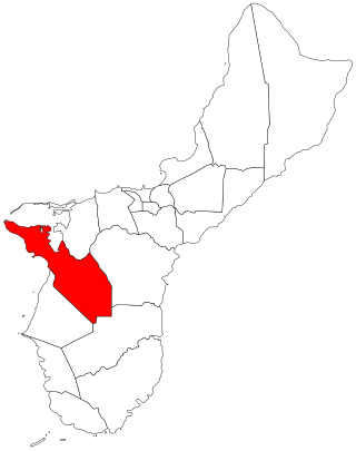
Tamuning, also known as Tamuning-Tumon-Harmon is a village located on the western shore of the United States territory of Guam. The village of Tamuning is the economic center of Guam, containing tourist center Tumon, Harmon Industrial Park, and other commercial districts. Its central location along Marine Corps Drive, the island's main thoroughfare, has aided in its development.

<span class="mw-page-title-main">Asan-Maina, Guam</span> Village in Guam, United States

Asan-Maina is a village located on the western shore of the United States territory of Guam. The municipality combines the names of the coastal community of Asan with Maina, a community along the slopes of the Fonte River valley to the east. Asan was the northern landing site for United States Marines during Guam's liberation from the Japanese during World War II. Asan Beach Park is part of the War in the Pacific National Historic Park. The third community comprising Asan-Maina is Nimitz Hill Annex in the hills above Asan and Maina, which is the location of the Joint Region Marianas headquarters. Asan-Maina is located in the Luchan (Western) District.

<span class="mw-page-title-main">Sånta Rita-Sumai, Guam</span> Village in Guam, United States

Sånta Rita-Sumai, formerly Santa Rita and encompassing the former municipality of Sumay, is a village located on the southwest coast of the United States territory of Guam with hills overlooking Apra Harbor. According to the 2020 census it has a population of 6,470, which is up slightly from 6,084 in 2010 but down from 11,857 in 1990. Santa Rita is the newest village in Guam, having been established after the Second World War.

<span class="mw-page-title-main">Yona, Guam</span> Village in Guam, United States

Yona is a village in the United States territory of Guam.

<span class="mw-page-title-main">Agana Heights, Guam</span> Village in Guam, United States

Agana Heights is one of the nineteen villages in the United States territory of Guam. It is located in the hills south of Hagåtña, in the central part of the island. United States Naval Hospital Guam is located in this largely residential village.

<span class="mw-page-title-main">Sinajana, Guam</span> Village in Guam, United States

Sinajana is the smallest of the nineteen villages in the United States territory of Guam by area. It is located in the hills south of Hagåtña. The village's name may have come from the word "china-jan," cookware used to cook wild yams that once grew in the area.

The Guam Department of Education (GDOE), formerly the Guam Public School System, is a school district that serves the United States territory of Guam. The school district can be thought of as analogous to the school districts of other cities and communities in the United States, but in some manners, it can also be thought of as analogous to the state education agencies of other states and territories.

<span class="mw-page-title-main">Mongmong-Toto-Maite, Guam</span> Village in Guam, United States

Mongmong-Toto-Maite is a municipality in the United States territory of Guam composed of three separate villages east of Hagåtña that experienced development after the Second World War.

<span class="mw-page-title-main">George Washington High School (Guam)</span> School in Mangilao, Guam

George Washington High School is a public secondary school located at 298 Washington Drive in Mangilao, in the United States territory of Guam.

The Guam Department of Corrections is an agency of the government of the United States territory of Guam that operates the island's correctional facilities.

<span class="mw-page-title-main">Talo'fo'fo, Guam</span> Village in Guam, United States

Talo'fo'fo, formerly Talofofo, is a village located in the southern part of the United States territory of Guam, on the east coast. The village center is located in the hills above the coast, while the smaller coastal community below the cliff is known as Ipan.

<span class="mw-page-title-main">Inalåhan, Guam</span> Village in Guam, United States

Inalåhan is a village located on the southeastern coast of the United States territory of Guam. The village's original Chamoru name, Inalåhan, was altered when transliterated during Spanish control of the island.

<span class="mw-page-title-main">Dededo</span> Village in Guam, United States

Dededo is the most populated village in the United States territory of Guam. According to the U.S. Census Bureau, Dededo's population was just under 45,000 in 2020. The village is located on the coral plateau of Northern Guam. The greater Dededo-Machanao-Apotgan Urban Cluster had a population of 139,825 as of the 2010 census, making up 87.7% of Guam's population and 29.8% of its area.

<span class="mw-page-title-main">Yigo, Guam</span> Village in Guam, United States

Yigo, Guam is the northernmost village of the United States territory of Guam, and is the location of Andersen Air Force Base. The municipality of Yigo is the largest village on the island in terms of area. It contains a number of populated places, including Asatdas and Agafo Gumas.

<span class="mw-page-title-main">Chalan Pago-Ordot, Guam</span> Village in Guam, United States

Chalan Pago-Ordot is a village in the United States territory of Guam, containing the communities of Chalan Pago and Ordot. It is located in the eastern-central part of the island and is part of the Kattan (Eastern) District. The village's population has increased slightly since the island's 2010 census.

<span class="mw-page-title-main">Barrigada, Guam</span> Village in Guam, United States

Barrigada is a village in the United States territory of Guam. A largely residential municipality, its main village is located south of the Antonio B. Won Pat International Airport near the intersections of Routes 8, 10, and 16. The community east of the airport known as Barrigada Heights is considered an affluent neighborhood on the island, where homes have excellent views overlooking much of Guam including the island's airport and hotels along Tumon Bay. Another significant location is Mount Barrigada, nearly 200 meters above sea level. Its location in the center of the island means it houses most of the island's radio masts and towers; the position and height make it easier for radio signals to reach the entire island.

<span class="mw-page-title-main">Malesso, Guam</span> Village in Guam, United States

Malesso' is the southernmost village in the United States territory of Guam. Cocos Island is a part of the municipality. The village's population has decreased since the island's 2010 census.

<span class="mw-page-title-main">Asan, Guam</span> Census-designated place in Guam, United States

Asan is a community and census-designated place (CDP) along the western coast of the U.S. territory of Guam. Asan, along with Maina and Nimitz Hill Annex, are the three communities in the village of Asan-Maina. It is known for being the location of northern invasion beach used by the United States during the retaking of Guam in 1944.

References

  1. 1 2 3 Population of Guam: 2010 and 2020, U.S. Census Bureau.
  2. "2010 CENSUS - CENSUS BLOCK MAP: Mangilao CDP, GU" (PDF). U.S. Census Bureau . Retrieved 2020-10-09. - See "Mangilao muny"
  3. "2010 CENSUS - CENSUS BLOCK MAP: Adacao CDP, GU" (PDF). U.S. Census Bureau . Retrieved 2020-10-09. - See "Mangilao muny"
  4. "2010 CENSUS - CENSUS BLOCK MAP: Pagat CDP, GU" (PDF). U.S. Census Bureau . Retrieved 2020-10-09. - See "Mangilao muny"
  5. "2010 CENSUS - CENSUS BLOCK MAP: University of Guam CDP, GU" (PDF). U.S. Census Bureau . Retrieved 2020-10-09.
  6. "Prison Security Archived 2010-09-24 at the Wayback Machine ." Guam Department of Corrections. Retrieved on May 19, 2010.
  7. "A CASE STUDY OF DEPARTMENT OF YOUTH AFFAIRS A REPORT TO OUR CITIZENS Archived 2011-07-26 at the Wayback Machine ." Guam Department of Youth Affairs. Retrieved on October 12, 2010. "Site Address: #169 San Isidro St. Mangilao Guam 96923."
  8. "Mangilao Area Map." Pacific Daily News . Retrieved on October 12, 2010.
  9. "Contact Us Archived 2010-05-27 at the Wayback Machine ." Guam Department of Agriculture. Retrieved on October 21, 2010. "163 Dairy Road Mangilao, Guam 96913."
  10. "Contact Us Archived 2010-08-28 at the Wayback Machine ." Guam Department of Public Health and Social Services. Retrieved on October 26, 2010. "Mailing Address: Mailing Address Department of Public Health and Social Services 123 Chalan Kareta, Mangilao, Guam 96913-6304."
  11. 1 2 "North and Central Guam Land Use Plan" (PDF). Government of Guam Bureau of Statistics and Plans. September 2009. p. 2-8 (PDF p. 24/64). Retrieved 2023-07-04.
  12. "Archived copy". Archived from the original on 2006-02-22. Retrieved 2006-02-22.{{cite web}}: CS1 maint: archived copy as title (link)
  13. "Guam's Public High Schools." Guam Public School System. Accessed September 8, 2008.
  14. "DoDEA Guam School Boundaries and Bus Transportation Zones". Military Morale, Welfare and Recreation Guam. Retrieved 2023-07-07.
  15. "Welcome Archived 2011-07-05 at archive.today ." Father Dueñas Memorial School. Retrieved on October 25, 2010. "Mailing Address: 176 Duenas Ln Mangilao 96913."
  16. "Top." Japanese School of Guam. Retrieved on January 10, 2012. "170 TERAO ST. MANGILAO GUAM 96913"
  17. "GNIS Detail - Adacao Census Designated Place". geonames.usgs.gov. Retrieved 2017-02-21.
  18. "GNIS Detail - Asbeco". geonames.usgs.gov. Retrieved 2017-02-21.
  19. "GNIS Detail - Latte Heights Census Designated Place". geonames.usgs.gov. Retrieved 2017-02-21.

13°26′56″N144°48′01″E / 13.44889°N 144.80028°E / 13.44889; 144.80028