Manukan, Zamboanga del Norte

Last updated
Manukan
Municipality of Manukan
Manukan Rooster Statue.jpg
Statue of Rooster along with Municipal Hall of Manukan
Flag of Manukan, Zamboanga del Norte.jpg
Seal of Manukan.png
Etymology: Manukan lit. Poultry
Ph locator zamboanga del norte manukan.png
Map of Zamboanga del Norte with Manukan highlighted
OpenStreetMap
Manukan, Zamboanga del Norte
Philippines location map (square).svg
Red pog.svg
Manukan
Location within the Philippines
Coordinates: 8°30′58″N123°05′30″E / 8.516139°N 123.091664°E / 8.516139; 123.091664
Country Philippines
Region Zamboanga Peninsula
Province Zamboanga del Norte
District 2nd district
Founded June 16, 1951
Barangays 22 (see Barangays)
Government
[1]
  Type Sangguniang Bayan
   Mayor Eugene U. Caballero
   Vice Mayor Enriquita U. Winters
   Representative Glona G. Labadlabad
   Municipal Council
Members
   Electorate 25,769 voters (2022)
Area
[2]
  Total246.35 km2 (95.12 sq mi)
Elevation
66 m (217 ft)
Highest elevation
427 m (1,401 ft)
Lowest elevation
0 m (0 ft)
Population
 (2020 census) [3]
  Total36,887
  Density150/km2 (390/sq mi)
   Households
8,560
Economy
   Income class 3rd municipal income class
   Poverty incidence
49.22
% (2018) [4]
   Revenue 189.8 million (2020)
   Assets 406.8 million (2020)
   Expenditure 180.4 million (2020)
   Liabilities 79.07 million (2020)
Service provider
  ElectricityZamboanga del Norte Electric Cooperative (ZANECO)
Time zone UTC+8 (PST)
ZIP code
7110
PSGC
IDD : area code +63(0)65
Native languages Subanon
Cebuano
Chavacano
Tagalog
Website manukan.zamboangadelnorte.com

Manukan, officially the Municipality of Manukan (Cebuano : Lungsod sa Manukan; Subanen: Benwa Manukan; Chavacano: Municipalidad de Manukan; Tagalog : Bayan ng Manukan), is a 3rd class municipality in the province of Zamboanga del Norte, Philippines. According to the 2020 census, it has a population of 36,887 people. [3]

Contents

It is located 38 kilometres (24 mi) west of Dipolog, the provincial capital, and 282 kilometres (175 mi) north-east of Zamboanga City, the regional capital.

History

During the Pre-Spanish era this town was inhabited by the Subanons. During the Spanish colonization, Manukan was a barrio part of Dapitan. In the creation of the municipality of Katipunan, this barrio became a barangay Manukan. Chickens were plenty and breeds that supply the northern part of Mindanao come from this town. "Manukan" word means poultry farm. On June 16, 1951, thru the effort of former Congressman (and later Senator) Roseller T. Lim with the help of Governor Serapio J. Datoc of the former Province of Zamboanga, President Elpidio Quirino signed into law Republic Act No. 655 creating the municipality of Manukan. [5] In 1952, the barrios of Manukan, Lipras, Dipane, Linay, Mate, Sirongan, Libuton, Disakan, Siparok, Ponot, and Manawan of Katipunan were formed into the town of Manukan. [6]

Sitio Libuton became a barangay in 1954. [7]

Lipras was renamed San Antonio in 1957. [8]

In 1979, by virtue of Batas Pambansa Blg. 15, seven barangays in the southwestern part of the municipality were separated to create the municipality of Ponot (now Jose Dalman). [9]

Geography

Climate

Climate data for Manukan, Zamboanga del Norte
MonthJanFebMarAprMayJunJulAugSepOctNovDecYear
Average high °C (°F)29
(84)
29
(84)
30
(86)
31
(88)
30
(86)
30
(86)
29
(84)
30
(86)
30
(86)
29
(84)
29
(84)
29
(84)
30
(85)
Average low °C (°F)23
(73)
23
(73)
23
(73)
24
(75)
25
(77)
25
(77)
24
(75)
24
(75)
24
(75)
24
(75)
24
(75)
24
(75)
24
(75)
Average precipitation mm (inches)104
(4.1)
76
(3.0)
92
(3.6)
97
(3.8)
199
(7.8)
238
(9.4)
195
(7.7)
193
(7.6)
178
(7.0)
212
(8.3)
171
(6.7)
110
(4.3)
1,865
(73.3)
Average rainy days14.712.515.817.527.628.529.027.526.927.923.518.2269.6
Source: Meteoblue [10]

Barangays

Manukan is politically subdivided into 22 barangays. Each barangay consists of puroks while some have sitios.

The central Poblacion is where the municipal seat is located. Nine of the barangays are along the national highway and the rest of them are mountain barangays, being three or more kilometers away from the national highway that runs mostly along the coast of the municipality.

  • Dipane
  • Disakan
  • Don Jose Aguirre
  • East Poblacion
  • Gupot
  • Libuton
  • Linay
  • Lingatongan
  • Lupasang
  • Mate
  • Meses
  • Palaranan
  • Pangandao
  • Patagan
  • Poblacion
  • Punta Blanca
  • Saluyong
  • San Antonio
  • Serongan
  • Suisayan
  • Upper Disakan
  • Villaramos

Demographics

Population census of Manukan
YearPop.±% p.a.
1960 19,886    
1970 27,286+3.21%
1975 33,444+4.17%
1980 23,112−7.12%
1990 28,554+2.14%
1995 29,681+0.73%
YearPop.±% p.a.
2000 31,855+1.53%
2007 33,129+0.54%
2010 35,589+2.64%
2015 36,526+0.50%
2020 36,887+0.19%
Source: Philippine Statistics Authority [11] [12] [13] [14]

Economy

Healthcare

Manukan is being served by the Medicare Community Hospital of Manukan, often known as Trifon H. Saile Memorial Hospital, a community hospital located in Barangay Poblacion.

Education

Related Research Articles

<span class="mw-page-title-main">Leon B. Postigo</span> Municipality in Zamboanga del Norte, Philippines

Leon B. Postigo, officially the Municipality of Leon B. Postigo, is a 4th class municipality in the province of Zamboanga del Norte, Philippines. According to the 2020 census, it has a population of 27,639 people.

<span class="mw-page-title-main">Baliguian</span> Municipality in Zamboanga del Norte, Philippines

Baliguian, officially the Municipality of Baliguian, is a 3rd class municipality in the province of Zamboanga del Norte, Philippines. According to the 2020 census, it has a population of 23,771 people.

<span class="mw-page-title-main">Gutalac</span> Municipality in Zamboanga del Norte, Philippines

Gutalac, officially the Municipality of Gutalac, is a 2nd class municipality in the province of Zamboanga del Norte, Philippines. According to the 2020 census, it has a population of 36,090 people.

<span class="mw-page-title-main">Jose Dalman</span> Municipality in Zamboanga del Norte, Philippines

Jose Dalman, officially the Municipality of Jose Dalman, is a 5th class municipality in the province of Zamboanga del Norte, Philippines. According to the 2020 census, it has a population of 28,881 people.

<span class="mw-page-title-main">Kalawit</span> Municipality in Zamboanga del Norte, Philippines

Kalawit, officially the Municipality of Kalawit, is a 4th class municipality in the province of Zamboanga del Norte, Philippines. According to the 2020 census, it has a population of 23,812 people.

<span class="mw-page-title-main">Katipunan, Zamboanga del Norte</span> Municipality in Zamboanga del Norte, Philippines

Katipunan, officially the Municipality of Katipunan, is a 2nd class municipality in the province of Zamboanga del Norte, Philippines. According to the 2020 census, it has a population of 44,661 people.

<span class="mw-page-title-main">Labason</span> Municipality in Zamboanga del Norte, Philippines

Labason, officially the Municipality of Labason, is a 3rd class municipality in the province of Zamboanga del Norte, Philippines. According to the 2020 census, it has a population of 43,934 people.

<span class="mw-page-title-main">Liloy</span> Municipality in Zamboanga del Norte, Philippines

Liloy, officially the Municipality of Liloy, is a 3rd class municipality in the province of Zamboanga del Norte, Philippines. According to the 2020 census, it has a population of 42,213 people.

<span class="mw-page-title-main">Piñan</span> Municipality in Zamboanga del Norte, Philippines

Piñan, officially the Municipality of Piñan, is a fourth-class municipality in the province of Zamboanga del Norte, Philippines. According to the 2020 census, it has a population of 20,221 people.

<span class="mw-page-title-main">Polanco, Zamboanga del Norte</span> Municipality in Zamboanga del Norte, Philippines

Polanco, officially the Municipality of Polanco, is a 3rd class municipality in the province of Zamboanga del Norte, Philippines. According to the 2020 census, it has a population of 42,265 people.

<span class="mw-page-title-main">Rizal, Zamboanga del Norte</span> Municipality in Zamboanga del Norte, Philippines

Rizal, officially the Municipality of Rizal, is a 5th class municipality in the province of Zamboanga del Norte, Philippines. According to the 2020 census, it has a population of 15,052 people.

<span class="mw-page-title-main">Salug</span> Municipality in Zamboanga del Norte, Philippines

Salug, officially the Municipality of Salug, is a 3rd class municipality in the province of Zamboanga del Norte, Philippines. As of the 2020 census, it had a population of 32,134 people.

<span class="mw-page-title-main">Sergio Osmeña, Zamboanga del Norte</span> Municipality in Zamboanga del Norte, Philippines

Sergio Osmeña, officially the Municipality of Sergio Osmeña Sr., is a 2nd class municipality in the province of Zamboanga del Norte, Philippines. According to the 2020 census, it has a population of 31,942 people.

<span class="mw-page-title-main">Sibutad</span> Municipality in Zamboanga del Norte, Philippines

Sibutad, officially the Municipality of Sibutad, is a 5th class municipality in the province of Zamboanga del Norte, Philippines. According to the 2020 census, it has a population of 17,453 people.

<span class="mw-page-title-main">Tampilisan</span> Municipality in Zamboanga del Norte, Philippines

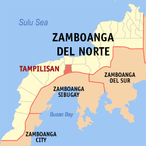
Tampilisan, officially the Municipality of Tampilisan, is a 4th class municipality in the province of Zamboanga del Norte, Philippines. According to the 2020 census, it has a population of 24,680 people.

<span class="mw-page-title-main">Aurora, Zamboanga del Sur</span> Municipality in Zamboanga del Sur, Philippines

Aurora, officially the Municipality of Aurora, is a 2nd class municipality in the province of Zamboanga del Sur, Philippines. According to the 2020 census, it has a population of 52,995 people.

<span class="mw-page-title-main">Dimataling</span> Municipality in Zamboanga del Sur, Philippines

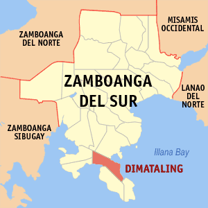
Dimataling, officially the Municipality of Dimataling, is a 4th class municipality in the province of Zamboanga del Sur, Philippines. According to the 2020 census, it has a population of 31,340 people.

<span class="mw-page-title-main">Midsalip</span> Municipality in Zamboanga del Sur, Philippines

Midsalip, officially the Municipality of Midsalip, is a 4th class municipality in the province of Zamboanga del Sur, Philippines. According to the 2020 census, it has a population of 33,711 people.

<span class="mw-page-title-main">Ramon Magsaysay, Zamboanga del Sur</span> Municipality in Zamboanga del Sur, Philippines

Ramon Magsaysay, officially the Municipality of Ramon Magsaysay, is a 4th class municipality in the province of Zamboanga del Sur, Philippines. According to the 2020 census, it has a population of 27,280 people.

<span class="mw-page-title-main">Vincenzo A. Sagun</span> Municipality in Zamboanga del Sur, Philippines

Vincenzo A. Sagun, officially the Municipality of Vincenzo A. Sagun, is a 5th class municipality in the province of Zamboanga del Sur, Philippines. According to the 2020 census, it has a population of 24,852 people.

References

  1. Municipality of Manukan | (DILG)
  2. "2015 Census of Population, Report No. 3 – Population, Land Area, and Population Density" (PDF). Philippine Statistics Authority. Quezon City, Philippines. August 2016. ISSN   0117-1453. Archived (PDF) from the original on May 25, 2021. Retrieved July 16, 2021.
  3. 1 2 Census of Population (2020). "Region IX (Zamboanga Peninsula)". Total Population by Province, City, Municipality and Barangay. Philippine Statistics Authority . Retrieved 8 July 2021.
  4. "PSA Releases the 2018 Municipal and City Level Poverty Estimates". Philippine Statistics Authority. 15 December 2021. Retrieved 22 January 2022.
  5. "Zamboanga del Norte : Municipality of Manukan". Old Website of Province of Zamboanga del Norte. Archived from the original on 26 August 2002. Retrieved 21 November 2020.
  6. "An Act Creating the Municipality of Manukan in the Province of Zamboanga". LawPH.com. Retrieved 2011-04-09.
  7. "An Act to Create the Barrio of Libuton in the Municipality of Manukan, Province of Zamboanga Del Norte". LawPH.com. Retrieved 2011-04-11.
  8. "An Act Changing the Name of Barrio Lipras, Municipality of Manukan, Province of Zamboanga Del Norte, to Villa Ramos". LawPH.com. Retrieved 2011-04-12.
  9. "Batas Pambansa Blg. 15". The LawPhil Project. Arellano Law Foundation. January 3, 1979. Retrieved March 22, 2023.
  10. "Manukan: Average Temperatures and Rainfall". Meteoblue. Retrieved 30 April 2020.
  11. Census of Population (2015). "Region IX (Zamboanga Peninsula)". Total Population by Province, City, Municipality and Barangay. Philippine Statistics Authority . Retrieved 20 June 2016.
  12. Census of Population and Housing (2010). "Region IX (Zamboanga Peninsula)". Total Population by Province, City, Municipality and Barangay. National Statistics Office . Retrieved 29 June 2016.
  13. Censuses of Population (1903–2007). "Region IX (Zamboanga Peninsula)". Table 1. Population Enumerated in Various Censuses by Province/Highly Urbanized City: 1903 to 2007. National Statistics Office.
  14. "Province of Zamboanga del Norte". Municipality Population Data. Local Water Utilities Administration Research Division. Retrieved 17 December 2016.
  15. "Poverty incidence (PI):". Philippine Statistics Authority. Retrieved December 28, 2020.
  16. "Estimation of Local Poverty in the Philippines" (PDF). Philippine Statistics Authority. 29 November 2005.
  17. "2003 City and Municipal Level Poverty Estimates" (PDF). Philippine Statistics Authority. 23 March 2009.
  18. "City and Municipal Level Poverty Estimates; 2006 and 2009" (PDF). Philippine Statistics Authority. 3 August 2012.
  19. "2012 Municipal and City Level Poverty Estimates" (PDF). Philippine Statistics Authority. 31 May 2016.
  20. "Municipal and City Level Small Area Poverty Estimates; 2009, 2012 and 2015". Philippine Statistics Authority. 10 July 2019.
  21. "PSA Releases the 2018 Municipal and City Level Poverty Estimates". Philippine Statistics Authority. 15 December 2021. Retrieved 22 January 2022.