Socorro County is a county in the U.S. state of New Mexico. As of the 2010 census, the population was 17,866. The county seat is Socorro. The county was formed in 1852 as one of the original nine counties of New Mexico Territory. Socorro was originally the name given to a Native American village by Don Juan de Oñate in 1598. Having received vitally needed food and assistance from the native population, Oñate named the pueblo Socorro.

Guadalupe Mountains National Park is an American national park in the Guadalupe Mountains, east of El Paso, Texas. The mountain range includes Guadalupe Peak, the highest point in Texas at 8,749 feet (2,667 m), and El Capitan used as a landmark by travelers on the route later followed by the Butterfield Overland Mail stagecoach line. The ruins of a stagecoach station stand near the Pine Springs visitor center. The restored Frijole Ranch contains a small museum of local history and is the trailhead for Smith Spring. The park covers 86,367 acres in the same mountain range as Carlsbad Caverns National Park, about 25 miles (40 km) to the north in New Mexico. The Guadalupe Peak Trail winds through pinyon pine and Douglas-fir forests as it ascends over 3,000 feet (910 m) to the summit of Guadalupe Peak, with views of El Capitan and the Chihuahuan Desert.
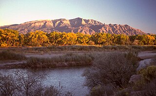
The Sandia Mountains are a mountain range located in Bernalillo and Sandoval counties, immediately to the east of the city of Albuquerque in New Mexico in the southwestern United States. The range is largely within the Cibola National Forest, and part of the range is protected as the Sandia Mountain Wilderness. Its highest point is Sandia Crest, 10,678 feet (3,255 m).

The Sangre de Cristo Mountains are the southernmost subrange of the Rocky Mountains. They are located in southern Colorado and northern New Mexico in the United States. The mountains run from Poncha Pass in South-Central Colorado, trending southeast and south, ending at Glorieta Pass, southeast of Santa Fe, New Mexico. The mountains contain a number of fourteen thousand foot peaks in the Colorado portion, as well as all the peaks in New Mexico which are over thirteen thousand feet.

Guadalupe Peak, also known as Signal Peak, is the highest natural point in Texas, with an elevation of 8,751 feet (2,667 m) above sea level. It is located in Guadalupe Mountains National Park, and is part of the Guadalupe Mountains range in southeastern New Mexico and West Texas. The mountain is about 90 miles (140 km) east of El Paso and about 50 miles (80 km) southwest of Carlsbad, New Mexico. The peak rises more than 3,000 feet (910 m) above the arid floor of the Chihuahuan Desert.

The Cibola National Forest is a 1,633,783 acre United States National Forest in New Mexico, USA. The name Cibola is thought to be the original Zuni Indian name for their pueblos or tribal lands. The name was later interpreted by the Spanish to mean, "buffalo." The forest is disjointed with lands spread across central and northern New Mexico, west Texas and Oklahoma. The Cibola National Forest is divided into four Ranger Districts: the Sandia, Mountainair, Mt. Taylor, and Magdalena. The Forest includes the San Mateo, Magdalena, Datil, Bear, Gallina, Manzano, Sandia, Mt. Taylor, and Zuni Mountains of west-central New Mexico. The Forest also manages four National Grasslands that stretch from northeastern New Mexico eastward into the Texas Panhandle and western Oklahoma. The Cibola National Forest and Grassland is administered by Region 3 of the United States Forest Service from offices in Albuquerque, New Mexico. Elevation ranges from 5,000 ft to 11,301 ft. The descending order of Cibola National Forest acres by county are: Socorro, Cibola, McKinley, Catron, Torrance, Bernalillo, Sandoval County, New Mexico, Lincoln, Sierra, and Valencia counties in New Mexico. The Cibola National Forest currently has 137,701 acres designated as Wilderness. In addition to these acres, it has 246,000 acres classified as Inventoried Roadless Areas pursuant to the Roadless Area Conservation Rule.

The Sacramento Mountains are a mountain range in the south-central part of the U.S. state of New Mexico, lying just east of Alamogordo in Otero County. From north to south, the Sacramento Mountains extend for 85 miles (137 km), and from east to west they encompass 42 miles (68 km).

The Zuni Mountains are a mountain range located mainly in Cibola County of northwestern New Mexico, with a small portion extending into McKinley County. The range is located largely in the Cibola National Forest, lying south of Interstate 40 from southeast of Gallup to southwest of Grants. The range is about sixty miles long and forty miles wide. The highest point is Mount Sedgwick, 9,256 feet ; elevations in the range go down to 6,400 feet.

The Magdalena Mountains are a regionally high, mountain range in Socorro County, in west-central New Mexico in the southwestern United States. The highest point in the range is South Baldy, at 10,783 ft, which is also the tallest peak in Socorro County. The range runs roughly north-south and is about 18 miles (28 km) long. The range lies just south of the village of Magdalena, and about 18 miles (28 km) west of Socorro. The Magdalena Mountains are an east-tilted fault-block range, superimposed on Cenozoic calderas. The complex geologic history of the range has resulted in spectacular scenery, with unusual and eye-catching rock formations. They form part of the western edge of the Rio Grande Rift Valley, fronting the La Jencia Basin. The mountains remain isolated and natural due to the absence of any significant human development within or near the range.

South Baldy is the highest point of the Magdalena Mountains in central New Mexico, in the United States. It is in the Magdalena Ranger District of the Cibola National Forest, about 9 mi (15 km) south of Magdalena and 18 mi (30 km) west-southwest of Socorro. It lies just north of the Langmuir Laboratory for Atmospheric Research of the New Mexico Institute of Mining and Technology, and site of the Magdalena Ridge Observatory Interferometer.

Whitewater Baldy is the highest point of the Mogollon Mountains and the 3rd highest mountain in Southern New Mexico, after Sierra Blanca Peak and Lincoln County's Lookout Mountain. It is located in Catron County in the Gila Wilderness, part of the Gila National Forest. It lies about 15 miles (24 km) east of the town of Glenwood.

The San Mateo Mountains are a mountain range in Socorro County, in west-central New Mexico in the southwestern United States. The highest point in the range is West Blue Mountain, at 10,336 ft. The range runs roughly north-south and is about 40 miles (64 km) long. It lies about 25 miles (40 km) north-northwest of the town of Truth or Consequences and about 30 miles (48 km) southwest of Socorro. They should not be confused with the identically named range in Cibola and McKinley counties, north of this range.
West Blue Mountain is the highest peak in the San Mateo Mountains of southwestern New Mexico, in the United States. It rises in the southern half of the range, far from any paved road, making access difficult and traffic on the surrounding trails very light. Its summit is the highest point in the Apache Kid Wilderness of the Cibola National Forest.
The San Mateo Mountains are a small mountain range in Cibola and McKinley counties of New Mexico, in the southwestern United States. The highest point in the range is Mount Taylor, at 11,301 ft. The range lies just northeast of the community of Grants, and about 60 miles (100 km) west of Albuquerque. This range should not be confused with the identically named range in Socorro County, south of this range.

Sandia Mountain Wilderness, part of Cibola National Forest, is located east of Albuquerque, New Mexico, and comprises much of Sandia Mountains. It became part of the National Wilderness Preservation System in 1978 by an act of the United States Congress and has a total of 37,877 acres (15,328 ha).
The Animas Mountains are a small mountain range in Hidalgo County, within the "Boot-Heel" region of far southwestern New Mexico, in the United States. They extend north-south for about 30 miles (50 km) along the Continental Divide, from near the town of Animas to a few miles north of the border with Mexico. The range is about 12 miles (20 km) wide at its widest. The highest point of the range is the southern summit of the mile-long Animas Peak massif, 8,565 feet (2,611 m). The Animas Mountains lie between the Animas Valley on the west and the Playas Valley on the east. Nearby ranges include the Peloncillo Mountains, across the Animas Valley, and the Big Hatchet and Little Hatchet Mountains, across the Playas Valley. Physiographically, the range divides into two parts. The compact southern part, which includes Animas Peak, is higher and wider, rising up to 4,000 ft above the nearby valleys. It has a sky island character, with dense coniferous forests at the higher elevations. The longer, narrow northern portion is lower, reaching only 7,310 ft at Gillespie Peak, and is characterized by grassland and piñon-juniper woods and shrubs. The Animas Mountains lie near the Chihuahuan Desert, the Sonoran Desert, the Sierra Madre Occidental of Mexico, and the mountains surrounding the headwaters of the Gila River. Biotic influences from these regions, as well as the more distant Rocky Mountains, give the southern portion of the range a great diversity of species, including "approximately 130 species of birds, 60 species of mammals, and 40 species of reptiles."
Ladrón Peak is an isolated, highly visible peak in central New Mexico, lying about 50 mi (80 km) southwest of Albuquerque. Ladron Peak is the only major peak in the compact range known as the Sierra Ladrones, which lies between the Rio Puerco to the east and the Rio Salado to the southwest.
Apache Kid Wilderness is a 44,626-acre (18,060 ha) Wilderness area located within the Magdalena Ranger District of the Cibola National Forest in the state of New Mexico. Straddling a southern portion of the San Mateo Mountains of southwestern Socorro County, the area is characterized by rugged, narrow, and steep canyons bisecting high mountain peaks exceeding 10,000 feet (3,000 m). The Apache Kid Wilderness lies just south of the Withington Wilderness, which also straddles the San Mateo Mountains. The Apache Kid is also surrounded by 84,527 total acres of Inventoried Roadless Area (IRA) with the San Jose IRA to the south and the Apache Kid Contiguous IRA to the north, east, and west. Some 68 miles (109 km) of trails provide access to the Apache Kid Wilderness. The Wilderness was designated by Congress in 1980 and provides outstanding hiking, backpacking, star-gazing, hunting, and horseback-riding opportunities.

Manzano Mountain Wilderness is a designated Wilderness Area within the Cibola National Forest, located about 50 miles (80 km) south-southeast of Albuquerque. It is located in western Torrance County and eastern Valencia County. The Wilderness area includes 36,875 acres (14,923 ha) with elevations ranging from 6,100 feet (1,900 m) to 10,098 feet (3,078 m) at Manzano Peak.