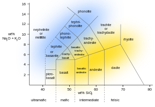
Extrusive rock refers to the mode of igneous volcanic rock formation in which hot magma from inside the Earth flows out (extrudes) onto the surface as lava or explodes violently into the atmosphere to fall back as pyroclastics or tuff. In contrast, intrusive rock refers to rocks formed by magma which cools below the surface.

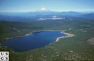
The Lassen volcanic area presents a geological record of sedimentation and volcanic activity in and around Lassen Volcanic National Park in Northern California, U.S. The park is located in the southernmost part of the Cascade Mountain Range in the Pacific Northwest region of the United States. Pacific Oceanic tectonic plates have plunged below the North American Plate in this part of North America for hundreds of millions of years. Heat and molten rock from these subducting plates has fed scores of volcanoes in California, Oregon, Washington and British Columbia over at least the past 30 million years, including these in the Lassen volcanic areas.
Medicine Lake Volcano is a large shield volcano in northeastern California about 30 mi (50 km) northeast of Mount Shasta. The volcano is located in a zone of east-west crustal extension east of the main axis of the Cascade Volcanic Arc and the Cascade Range. The 0.6 mi (1 km) thick shield is 22 mi (35 km) from east to west and 28 to 31 mi from north to south, and covers more than 770 sq mi (2,000 km2). The underlying rock has downwarped by 0.3 mi (0.5 km) under the center of the volcano. The volcano is primarily composed of basalt and basaltic andesite lava flows, and has a 4.3 by 7.5 mi caldera at the center.
A volcanic field is an area of Earth's crust that is prone to localized volcanic activity. The type and number of volcanoes required to be called a "field" is not well-defined. Volcanic fields usually consist of clusters of up to 100 volcanoes such as cinder cones. Lava flows may also occur. They may occur as a monogenetic volcanic field or a polygenetic volcanic field.

The Taos Plateau volcanic field is an area of extensive volcanism in Taos County, New Mexico, United States. It is the largest volcanic field in the Rio Grande Rift, spreading over 7,000 square kilometers (2,700 sq mi). The total erupted volume is estimated at 420 cubic kilometers (100 cu mi). The age of most of the vents and associated lava flows in the field is estimated to be between 1.8 and 4 million years, with a few 22-million-year-old vents. The composition of the lavas varies from tholeiitic basalt to rhyolite. Landforms include sheet flows, cinder cones, and shield volcanoes. The sheet flows of the Servilleta Basalt are well-exposed in the Rio Grande Gorge carved by the Rio Grande. The highest point of the field is San Antonio Mountain at 10,908 feet (3,325 m).
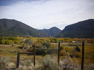
The Jemez Mountains are a group of mountains in Rio Arriba, Sandoval, and Los Alamos counties, New Mexico, United States.

Mount Taylor is a dormant stratovolcano in northwest New Mexico, northeast of the town of Grants. It is the high point of the San Mateo Mountains and the highest point in the Cibola National Forest.

Sierra Grande is an extinct stratovolcano in northeastern New Mexico that rises 2,200 feet above the surrounding plain. It is part of the inactive Raton-Clayton volcanic field.

Nevado de Longaví is a volcano in the Andes of central Chile. The 3,242 m (10,636 ft) high volcano lies in the Linares Province, which is part of the Maule Region. It features a summit crater and several parasitic vents. The volcano is constructed principally from lava flows. Two collapses of the edifice have carved collapse scars into the volcano, one on the eastern slope known as Lomas Limpias and another on the southwestern slope known as Los Bueye. The volcano features a glacier and the Achibueno and Blanco rivers originate on the mountain.

Ollagüe or Ullawi is a massive andesite stratovolcano in the Andes on the border between Bolivia and Chile, within the Antofagasta Region of Chile and the Potosi Department of Bolivia. Part of the Central Volcanic Zone of the Andes, its highest summit is 5,868 metres (19,252 ft) above sea level and features a summit crater that opens to the south. The western rim of the summit crater is formed by a compound of lava domes, the youngest of which features a vigorous fumarole that is visible from afar.
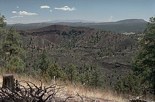
Zuni-Bandera volcanic field is a volcanic field located in the state of New Mexico, United States.

The Ocate volcanic field is a monogenetic volcanic field that extends from the southern Cimarron Range of the Sangre de Cristo Mountains to the vicinity of Wagon Mound, New Mexico. The town of Wagon Mound is named after The Wagon Mound, a prominent landmark that is a highly eroded volcanic neck of the volcanic field.

The Jemez Lineament is a chain of late Cenozoic volcanic fields, 800 kilometers (500 mi) long, reaching from the Springerville and White Mountains volcanic fields in East-Central Arizona to the Raton-Clayton volcanic field in Northeastern New Mexico.
Caja del Rio is a dissected plateau, of volcanic origin, which covers approximately 84,000 acres of land in northern Santa Fe County, New Mexico, United States. The region is also known as the Caja, Caja del Rio Plateau, and Cerros del Rio. The center of the area is approximately 15 miles (23 km) west of Santa Fe, New Mexico. Most of the Caja is owned by the United States Forest Service and managed by the Santa Fe National Forest. Access is through New Mexico Highway 599, Santa Fe County Road 62, and Forest Service Road 24.

The Canadian Cascade Arc, also called the Canadian Cascades, is the Canadian segment of the North American Cascade Volcanic Arc. Located entirely within the Canadian province of British Columbia, it extends from the Cascade Mountains in the south to the Coast Mountains in the north. Specifically, the southern end of the Canadian Cascades begin at the Canada–United States border. However, the specific boundaries of the northern end are not precisely known and the geology in this part of the volcanic arc is poorly understood. It is widely accepted by geologists that the Canadian Cascade Arc extends through the Pacific Ranges of the Coast Mountains. However, others have expressed concern that the volcanic arc possibly extends further north into the Kitimat Ranges, another subdivision of the Coast Mountains, and even as far north as Haida Gwaii.
San Borja volcanic field is a volcanic field in Baja California, northeast of the Vizcaino Peninsula. It is formed by a plateau of lava flows and a number of scoria cones. The field started erupting over twelve million years ago and has endured several changes in regional tectonics.

Antofalla is a Miocene-Pliocene volcano in Argentina's Catamarca Province. It is part of the volcanic segment of the Andes in Argentina, and it is considered to be part of the Central Volcanic Zone, one of the volcanic zones of the Andes. Antofalla forms a group of volcanoes that are aligned on and behind the main volcanic arc. Antofalla itself is a remote volcano.
The Polvadera Group is a group of geologic formations exposed in and around the Jemez Mountains of northern New Mexico. Radiometric dating gives it an age of 13 to 2.2 million years, corresponding to the Miocene through early Quaternary.
The Keres Group is a group of geologic formations exposed in and around the Jemez Mountains of northern New Mexico. Radiometric dating gives it an age of 13 to 6 million years, corresponding to the Miocene epoch.
The Latir volcanic field is a large volcanic field near Questa, New Mexico, that was active during the late Oligocene to early Miocene, 28 to 22 million years ago (Ma). It includes the Questa caldera, in whose deeply eroded interior is located the Molycorp Questa molybdenum mine.
