List of volcanoes in the United States

Last updated

This article contains a list of volcanoes in the United States and its territories.

Contents

Alaska

NameElevationLocationLast eruption
metersfeet Coordinates
Mount Adagdak 6452115 51°59′16″N176°35′30″W / 51.98778°N 176.59167°W / 51.98778; -176.59167 (Mount Adagdak) 210,000 ± 5,000 years ago
Mount Akutan 13034275 54°8′4″N165°59′10″W / 54.13444°N 165.98611°W / 54.13444; -165.98611 (Mount Akutan) 1996
Alagogshak 16755495 59°09′26″N155°23′54″W / 59.15722°N 155.39833°W / 59.15722; -155.39833 (Alagogshak) 43,000 ± 8,000 years ago
Amak Volcano 4881601 55°25′26″N163°8′57″W / 55.42389°N 163.14917°W / 55.42389; -163.14917 (Mount Amak) 1796
Mount Amukta 10663497 52°30′0″N171°15′8″W / 52.50000°N 171.25222°W / 52.50000; -171.25222 (Mount Amukta) 1997
Mount Aniakchak 13414400 56°53′0″N158°10′0″W / 56.88333°N 158.16667°W / 56.88333; -158.16667 (Mount Aniakchak) 1931
Mount Augustine 12524108 59°21′48″N153°26′0″W / 59.36333°N 153.43333°W / 59.36333; -153.43333 (Mount Augustine) 2005
Black Peak 10323385 56°33′11″N158°47′12″W / 56.55306°N 158.78667°W / 56.55306; -158.78667 (Black Peak) 1900 BCE ± 150 years
Bogoslof Island 150492 53°56′0″N168°2′0″W / 53.93333°N 168.03333°W / 53.93333; -168.03333 (Bogoslof Island) 2017
Buldir Volcano 6562152 52°21′0″N175°54′38″W / 52.35000°N 175.91056°W / 52.35000; -175.91056 (Mount Buldir) Holocene
Mount Bona 500516,421 61°23′6″N141°45′3″W / 61.38500°N 141.75083°W / 61.38500; -141.75083 (Mount Bona) 847
Mount Blackburn 499616,390 61°43′54″N143°25′59″W / 61.73167°N 143.43306°W / 61.73167; -143.43306 3.4 million years ago
Buzzard Creek 8302723 64°3′40″N148°24′55″W / 64.06111°N 148.41528°W / 64.06111; -148.41528 (Buzzard Creek) 1050 BC
Capital Mountain 23567728 62°26′N144°06′W / 62.43°N 144.10°W / 62.43; -144.10 (Capital) 1.02 million years ago [1]
Mount Carlisle 16205315 52°53′38″N170°3′15″W / 52.89389°N 170.05417°W / 52.89389; -170.05417 (Mount Carlisle) 1987
Chagulak Island 11423747 52°34′36″N171°8′0″W / 52.57667°N 171.13333°W / 52.57667; -171.13333 (Mount Chagulak) Unknown
Mount Chiginagak 22217287 57°8′6″N156°59′24″W / 57.13500°N 156.99000°W / 57.13500; -156.99000 (Mount Chiginagak) 1998
Mount Cleveland 17305676 52°49′30″N169°56′38″W / 52.82500°N 169.94389°W / 52.82500; -169.94389 (Mount Cleveland) 2020 [2]
Mount Dana 13544442 55°38′28″N161°12′50″W / 55.64111°N 161.21389°W / 55.64111; -161.21389 (Mount Dana) 1890 BC
Davidof Volcano 3281076 51°57′15″N178°19′34″E / 51.9542°N 178.326°E / 51.9542; 178.326 (Davidof Volcano) Probably Holocene
Mount Denison 23187606 58°25′4″N154°26′57″W / 58.41778°N 154.44917°W / 58.41778; -154.44917 (Mount Denison) Probably Holocene
Devils Desk 19546409 58°30′N154°18′W / 58.5°N 154.3°W / 58.5; -154.3 (Devils Desk) 245,000 years ago
Double glacier volcano 12394065 60°41′N152°37′W / 60.68°N 152.62°W / 60.68; -152.62 (Double Glacier) Pleistocene
Mount Douglas 21407021 58°51′19″N153°32′31″W / 58.85528°N 153.54194°W / 58.85528; -153.54194 (Mount Douglas) Probably Holocene
Mount Dutton 15064941 55°10′5″N162°16′18″W / 55.16806°N 162.27167°W / 55.16806; -162.27167 (Mount Dutton) Holocene
Mount Edgecumbe 9703132 57°3′0″N135°45′0″W / 57.05000°N 135.75000°W / 57.05000; -135.75000 (Mount Edgecumbe) 2220 BC ± 100 years
Mount Emmons 14364711 55°20′26″N164°4′43″W / 55.34056°N 164.07861°W / 55.34056; -164.07861 (Mount Emmons) More than 10,000 years ago [3]
Espenberg 66°21′N164°20′W / 66.35°N 164.33°W / 66.35; -164.33 (Espenberg) 17,500 years BP
Mount Fisher 11123648 54°39′0″N164°26′0″W / 54.65000°N 164.43333°W / 54.65000; -164.43333 (Mount Fisher) 1830
Fourpeaked 21056906 58°46′12″N153°40′20″W / 58.77000°N 153.67222°W / 58.77000; -153.67222 (Fourpeaked) 2006
Frosty Peak Volcano 19206299 55°04′55″N162°53′38″W / 55.082°N 162.894°W / 55.082; -162.894 (Cold Bay Volcano) Late Pleistocene or later
Gareloi Volcano 15735161 51°47′25″N178°47′38″W / 51.79028°N 178.79389°W / 51.79028; -178.79389 (Mount Gareloi) 1989
Mount Gilbert 8182684 54°15′08″N165°39′43″W / 54.2521°N 165.662°W / 54.2521; -165.662 (Mount Gilbert) Unknown, fumaroles until 1948 [4]
Great Sitkin 17405709 52°4′34″N176°7′48″W / 52.07611°N 176.13000°W / 52.07611; -176.13000 (Great Sitkin) Ongoing
Mount Gordon 27559039 62°8′0″N143°5′0″W / 62.13333°N 143.08333°W / 62.13333; -143.08333 (Mount Gordon) Holocene
Mount Griggs 23177602 58°21′14″N155°5′30″W / 58.35389°N 155.09167°W / 58.35389; -155.09167 (Mount Griggs) 1790 BC ± 40 years
Hayes Volcano 30349954 61°38′25″N152°24′41″W / 61.64028°N 152.41139°W / 61.64028; -152.41139 (Hayes Volcano) 1200 ± 300 years
Mount Herbert 12804199 52°44′32″N170°6′38″W / 52.74222°N 170.11056°W / 52.74222; -170.11056 (Mount Herbert) Unknown
Mount Iliamna 305310,016 60°1′55″N153°5′25″W / 60.03194°N 153.09028°W / 60.03194; -153.09028 (Mount Iliamna) 1876
Imuruk Lake 6102001 65°36′0″N163°55′0″W / 65.60000°N 163.91667°W / 65.60000; -163.91667 (Imuruk Lake) 300
Ingakslugwat Hills 190623 61°26′0″N164°28′0″W / 61.43333°N 164.46667°W / 61.43333; -164.46667 (Ingakslugwat Hills) Holocene
Isanotski Peaks 24468025 54°45′54″N163°43′21″W / 54.76500°N 163.72250°W / 54.76500; -163.72250 (Mount Isanotski) Unknown
Kagamil Island 8932930 52°58′25″N169°43′0″W / 52.97361°N 169.71667°W / 52.97361; -169.71667 (Mount Kagamil) 1929
Mount Kaguyak 9012956 58°36′30″N154°1′40″W / 58.60833°N 154.02778°W / 58.60833; -154.02778 (Mount Kaguyak) 1650 BC
Mount Kanaga 13074288 51°55′22″N177°10′4″W / 51.92278°N 177.16778°W / 51.92278; -177.16778 (Mount Kanaga) 2012
Kasatochi Island 3141030 52°10′39″N175°30′30″W / 52.17750°N 175.50833°W / 52.17750; -175.50833 (Kasatochi Island) 2008
Mount Katmai 20476716 58°16′47″N154°57′48″W / 58.27972°N 154.96333°W / 58.27972; -154.96333 (Mount Katmai) 1912
Kejulik Volcano 15174977 58°01′33″N155°39′17″W / 58.02583°N 155.65472°W / 58.02583; -155.65472 (Kejulik Volcano) Unknown
Mount Kialagvik 15755167 57°12′10″N156°44′43″W / 57.20278°N 156.74528°W / 57.20278; -156.74528 (Mount Kialagvik) Holocene [5]
Kiska Volcano 12204003 52°06′11″N177°36′13″E / 52.1031°N 177.6035°E / 52.1031; 177.6035 (Mount Kiska) 1990
Koniuji Island 273896 52°13′0″N175°8′0″W / 52.21667°N 175.13333°W / 52.21667; -175.13333 (Mount Koniuji) 1150 BC
Korovin Volcano 15335029 52°22′54″N174°9′57″W / 52.38167°N 174.16583°W / 52.38167; -174.16583 (Korovin Volcano) 2007
Mount Kukak 20436703 58°27′10″N154°21′18″W / 58.45278°N 154.35500°W / 58.45278; -154.35500 (Mount Kukak) Holocene [6]
Mount Kupreanof 18956217 56°0′40″N159°47′50″W / 56.01111°N 159.79722°W / 56.01111; -159.79722 (Mount Kupreanof) 1987
Kookooligit Mountains 6732208 63°36′0″N170°26′0″W / 63.60000°N 170.43333°W / 63.60000; -170.43333 (Kookooligit Mountains) Holocene
Little Sitkin 11743852 51°57′0″N178°32′35″W / 51.95000°N 178.54306°W / 51.95000; -178.54306 (Little Sitkin) 1830
Mount Mageik 21657103 58°11′41″N155°15′10″W / 58.19472°N 155.25278°W / 58.19472; -155.25278 (Mount Mageik) 500 BC ± 50 years
Mount Makushin 18005905 53°53′27″N165°55′22″W / 53.89083°N 165.92278°W / 53.89083; -165.92278 (Mount Makushin) 1995
Mount Martin 18636112 58°10′20″N155°21′40″W / 58.17222°N 155.36111°W / 58.17222; -155.36111 (Mount Martin) 1953
Mount Moffett 11963924 51°56′38″N176°44′48″W / 51.94389°N 176.74667°W / 51.94389; -176.74667 (Monte Moffett) 1600 BC
Novarupta 8412759 58°16′0″N155°9′24″W / 58.26667°N 155.15667°W / 58.26667; -155.15667 (Novarupta) 1912
Nunivak Island 5111676 60°1′0″N166°20′0″W / 60.01667°N 166.33333°W / 60.01667; -166.33333 (Nunivak Island) 300,000 years ago
Mount Okmok 10733520 53°26′0″N168°8′0″W / 53.43333°N 168.13333°W / 53.43333; -168.13333 (Mount Okmok) 2008
St. Michael volcanic field 7152346 63°27′0″N162°7′0″W / 63.45000°N 162.11667°W / 63.45000; -162.11667 (Saint Michael (volcano)) More recent than 500 BC
Saint Paul Island 203666 57°11′0″N170°18′0″W / 57.18333°N 170.30000°W / 57.18333; -170.30000 (Saint Paul Island) 1280 BC ± 40 years
Mount Pavlof 25198264 55°25′0″N161°53′15″W / 55.41667°N 161.88750°W / 55.41667; -161.88750 (Mount Pavlof) 2022
Pavlof Sister 21427027 55°27′10″N161°50′35″W / 55.45278°N 161.84306°W / 55.45278; -161.84306 (Pavlof Sister) 1786
Pogromni 20026569 54°34′N164°51′W / 54.57°N 164.85°W / 54.57; -164.85 (Pogromni) Late Pleistocene [7]
Pyre Peak 10543458 52°18′55″N172°35′30″W / 52.31528°N 172.59167°W / 52.31528; -172.59167 (Mount Seguam) 1993
Mount Recheschnoi 19846509 53°9′24″N168°32′20″W / 53.15667°N 168.53889°W / 53.15667; -168.53889 (Mount Recheschnoi) 3,000 years ago
Mount Redoubt 310810,197 60°29′7″N152°44′31″W / 60.48528°N 152.74194°W / 60.48528; -152.74194 (Mount Redoubt) 2009
Roundtop Mountain 18716138 54°48′0″N163°35′20″W / 54.80000°N 163.58889°W / 54.80000; -163.58889 (Mount Roundtop) 9,100-10,000 years ago [8]
Mount Sanford 494916,237 62°13′0″N144°8′0″W / 62.21667°N 144.13333°W / 62.21667; -144.13333 (Mount Sanford) 320,000 years ago
Mount Segula 11603806 52°0′55″N178°8′8″W / 52.01528°N 178.13556°W / 52.01528; -178.13556 (Mount Segula) A few hundred years ago
Semisopochnoi Island 12214006 51°56′0″N179°35′0″W / 51.93333°N 179.58333°W / 51.93333; -179.58333 (Mount Semisopochnoi) 2023
Mount Sergief 5601837 52°2′0″N174°56′0″W / 52.03333°N 174.93333°W / 52.03333; -174.93333 (Mount Sergief) Pleistocene [9]
Mount Shishaldin 28579373 54°45′20″N163°58′0″W / 54.75556°N 163.96667°W / 54.75556; -163.96667 (Mount Shishaldin) Ongoing
Snowy Mountain 21627093 58°20′8″N154°40′55″W / 58.33556°N 154.68194°W / 58.33556; -154.68194 (Snowy Mountain) 1710 ± 200 years
Mount Spurr 337411,069 61°17′58″N152°15′4″W / 61.29944°N 152.25111°W / 61.29944; -152.25111 (Mount Spurr) 1992
St. Michael volcanic field 7152346 63°27′0″N162°7′0″W / 63.45000°N 162.11667°W / 63.45000; -162.11667 (St. Michael) Within 3,000 years
St. Paul Island 203666 57°11′0″N170°18′0″W / 57.18333°N 170.30000°W / 57.18333; -170.30000 (St. Paul Island) 1280 BC ± 40 years
Mount Steller 22727454 58°26′0″N154°24′0″W / 58.43333°N 154.40000°W / 58.43333; -154.40000 (Mount Steller) Probably Holocene
Stepovak Bay 3 15555102 55°56′0″N160°0′0″W / 55.93333°N 160.00000°W / 55.93333; -160.00000 (Mount Stepovak) Probably Pleiocene
Table Top-Wide Bay 7922598 53°58′5″N166°40′38″W / 53.96806°N 166.67722°W / 53.96806; -166.67722 (Table Top-Wide Bay) Holocene [10]
Mount Takawangha 14494754 51°52′22″N178°0′20″W / 51.87278°N 178.00556°W / 51.87278; -178.00556 (Mount Takawangha) Last few hundred years [11]
Tana (volcano) 11703839 52°49′48″N169°16′12″W / 52.83000°N 169.27000°W / 52.83000; -169.27000 (Tana (volcano)) Mid-late Holocene [12]
Mount Tanaga 18065925 51°53′6″N178°8′45″W / 51.88500°N 178.14583°W / 51.88500; -178.14583 (Mount Tanaga) 1914
Tlevak Strait-Suemez Island 50164 55°15′0″N133°18′0″W / 55.25000°N 133.30000°W / 55.25000; -133.30000 (Tlevak Strait-Suemez Island) Holocene/Post-glacial [13]
Trident Volcano 18646115 58°14′8″N155°6′0″W / 58.23556°N 155.10000°W / 58.23556; -155.10000 (Trident Volcano) 1975
Ugashik-Peulik 14744836 57°45′3″N156°22′5″W / 57.75083°N 156.36806°W / 57.75083; -156.36806 (Ugashik-Peulik) 1814
Ukinrek maars 91299 57°49′54″N156°30′35″W / 57.83167°N 156.50972°W / 57.83167; -156.50972 (Ukinrek maars) 1977
Uliaga Island 8882913 53°3′54″N169°46′0″W / 53.06500°N 169.76667°W / 53.06500; -169.76667 (Mount Uliaga) Holocene
Mount Veniaminof 25078225 56°10′0″N159°23′0″W / 56.16667°N 159.38333°W / 56.16667; -159.38333 (Mount Veniaminof) 2021
Mount Vsevidof 21497050 53°7′48″N168°41′35″W / 53.13000°N 168.69306°W / 53.13000; -168.69306 (Mount Vsevidof) 1957
Mount Westdahl 16545426 54°31′6″N164°39′0″W / 54.51833°N 164.65000°W / 54.51833; -164.65000 (Mount Westdahl) 1992
Yantarni Volcano 13454413 57°1′17″N157°11′6″W / 57.02139°N 157.18500°W / 57.02139; -157.18500 (Yantarni Volcano) 800 BC ± 500 years
Yunaska Island 5501804 52°38′34″N170°37′43″W / 52.64278°N 170.62861°W / 52.64278; -170.62861 (Mount Yunaska) 1937
Prindle Volcano -- 63°43′N141°37′W / 63.72°N 141.62°W / 63.72; -141.62 (Prindle Volcano) Pleistocene
Mount Churchill 476615,632 61°15′N141°42′W / 61.25°N 141.7°W / 61.25; -141.7 (Mount Churchill) 700 ± 200 years
Mount Drum 366112,010 62°06′N144°30′W / 62.1°N 144.5°W / 62.1; -144.5 (Mount Drum) About 250,000 years ago [14]
Mount Jarvis 409113,422 62°1′4″N143°37′2″W / 62.01778°N 143.61722°W / 62.01778; -143.61722 (Mount Jarvis) 1 million years ago
Mount Wrangell 431714,163 62°00′N144°01′W / 62.00°N 144.02°W / 62.00; -144.02 (Mount Wrangell) 1999

American Samoa

NameElevationLocationLast eruption
metersfeet Coordinates
Malumalu Last 8,000 years
Ta‘u- 9313054 14°13′48″S169°27′14″W / 14.23°S 169.454°W / -14.23; -169.454 (Ta‘u-) 30,000 years ago [15]
Ofu-Olosega 6392096 14°10′30″S169°37′05″W / 14.175°S 169.618°W / -14.175; -169.618 (Ofu-Olosega) 1866 unnamed submarine cone eruption
Tutuila 6532142 14°17′42″S170°42′00″W / 14.295°S 170.70°W / -14.295; -170.70 (Tutuila) 440 CE [16]
Vailulu'u -592-1842 14°17′42″S170°42′00″W / 14.295°S 170.70°W / -14.295; -170.70 (Vailulu'u) 2003 west of unnamed submarine caldera and nafauna


Arizona

NameElevationLocationLast eruption
metersfeet Coordinates
Arlington Cone-- 33°20′55.6″N112°44′54.2″W / 33.348778°N 112.748389°W / 33.348778; -112.748389 -
Black Bottom Crater -- 35°23′54.02″N111°23′42.55″W / 35.3983389°N 111.3951528°W / 35.3983389; -111.3951528 -
Colton Crater 2,2467,368 35°32′42″N111°38′13.2″W / 35.54500°N 111.637000°W / 35.54500; -111.637000 (Colton Crater) 1075 AD Sunset Crater and Unnamed Fissure vents
Double Crater 2,4267,959 35°20′34.03″N111°26′51.55″W / 35.3427861°N 111.4476528°W / 35.3427861; -111.4476528 (Double Crater) Pleistocene
Lenox Crater -- 35°21′35.999″N111°31′47.62″W / 35.35999972°N 111.5298944°W / 35.35999972; -111.5298944 (Lenox Crater) -
Maroon Crater -- 35°26′32.02″N111°28′12.56″W / 35.4422278°N 111.4701556°W / 35.4422278; -111.4701556 (Maroon Crater) -
Merriam Cone 2,0776,813 35°18′N111°18′W / 35.300°N 111.300°W / 35.300; -111.300 (Merriam Cone) 150,000 years ago
Mount Baldy 3,48011,420 33°54′22″N109°33′46″W / 33.90611°N 109.56278°W / 33.90611; -109.56278 8-9 million years ago
Mount Elden 2,8349,299 35°14′28″N111°35′48″W / 35.24111°N 111.59667°W / 35.24111; -111.59667 (Mount Elden) 250,000 years ago
Red Mountain 24287965 35°31′23″N111°52′32″W / 35.52306°N 111.87556°W / 35.52306; -111.87556 740,000 years ago
Roden Crater -- 35°25′37.02″N111°15′27.76″W / 35.4269500°N 111.2577111°W / 35.4269500; -111.2577111 400,000 years ago
San Francisco Peaks 385112,633 35°20′47″N111°40′40″W / 35.34639°N 111.67778°W / 35.34639; -111.67778 (San Francisco Mountain) 92,000 years ago [17]
San Francisco volcanic field -- 35°21′51″N111°30′11″W / 35.36417°N 111.50306°W / 35.36417; -111.50306 (San Francisco volcanic field) 1075 AD ± 25 years
SP Crater 21417021 35°34′56″N111°37′55″W / 35.58222°N 111.63194°W / 35.58222; -111.63194 (SP Crater) 5,500 years ago
Stewart Crater -- 35°21′39.6″N111°24′14.4″W / 35.361000°N 111.404000°W / 35.361000; -111.404000 (Stewart Crater) -
Strawberry Crater 1,9896,526 35°26′32.02″N111°28′12.6″W / 35.4422278°N 111.470167°W / 35.4422278; -111.470167 (Double Strawberry Crater) Late Pleistocene
Sunset Crater (San Francisco volcanic field)24478026 35°21′51″N111°30′11″W / 35.36417°N 111.50306°W / 35.36417; -111.50306 (Sunset Crater) 1075 AD ± 25 years
Uinkaret volcanic field -- 36°13′7.93″N113°4′38.74″W / 36.2188694°N 113.0774278°W / 36.2188694; -113.0774278 (Uinkaret volcanic field) 1100 AD ± 75 years Little Springs Pyroclastic Cone

California

NameElevationLocationLast eruption
metersfeet Coordinates
Amboy Crater -

300

-

984

-

34°32′38″N115°47′28″W / 34.54389°N 115.79111°W / 34.54389; -115.79111 (Amboy Crater)

23 million years ago 79,000 ± 5,000 years ago
Big Cave 12594131 40°57′18″N121°21′54″W / 40.955°N 121.365°W / 40.955; -121.365 (Big Cave) 38,000 ± 7,000 years ago
Big Pine volcanic field 37°00′N118°15′W / 37.000°N 118.250°W / 37.000; -118.250 (Big Pine volcanic field) 17,000 years ago
Black Butte 19396362 41°22′01″N121°20′53″W / 41.367°N 121.348°W / 41.367; -121.348 (Black Butte) 9,500 years ago
Brushy Butte 11743852 41°10′41″N121°26′35″W / 41.178°N 121.443°W / 41.178; -121.443 (Brushy Butte) 12,000 years ago
Burney Mountain 23977863 40°49′N121°38′W / 40.81°N 121.63°W / 40.81; -121.63 (Burney Mountain) 280,000 ± 6,000 years ago [18]
Cima volcanic field 15096925 35°15′N115°45′W / 35.25°N 115.75°W / 35.25; -115.75 (Cima Volcanic Field) 15,000 ± 5,000 years ago
Cinder Cone and the Fantastic Lava Beds 21056907 40°33′N121°19′W / 40.55°N 121.32°W / 40.55; -121.32 1666
Inyo Craters 26298625 37°41′31″N119°01′12″W / 37.692°N 119.02°W / 37.692; -119.02 (Inyo Craters) 1380 CE ± 50 years
Mount Konocti (Clear Lake Volcanic Field)13124305 38°58′N122°46′W / 38.97°N 122.77°W / 38.97; -122.77 (California Coast Range) 11,000 years ago
Lassen Peak 318910,462 40°29′17″N121°30′18″W / 40.48806°N 121.50500°W / 40.48806; -121.50500 (Lassen Peak) 1917
Lassen Volcanic Center -- 40°29′30″N121°30′30″W / 40.49167°N 121.50833°W / 40.49167; -121.50833 (Lassen Volcanic Center) 1917
Long Valley Caldera 339011,122 37°36′N118°48′W / 37.6°N 118.8°W / 37.6; -118.8 (Long Valley Caldera) 50,000 years ago
Malapai Hill 13044278 33°54′N116°00′W / 33.9°N 116.0°W / 33.9; -116.0 (Malapi Hill) 15.93 ± 0.08 million years ago
Mammoth Mountain 337111,059 37°38′N119°02′W / 37.63°N 119.03°W / 37.63; -119.03 (Mammoth Mountain) 1260 AD ± 40 years
Medicine Lake Volcano 24127913 41°22′N121°20′W / 41.36°N 121.33°W / 41.36; -121.33 (Medicine Lake Volcano) 1060 AD
Mono Craters 2,7969,173 37°53′N119°00′W / 37.88°N 119.00°W / 37.88; -119.00 (Mono Craters) 1350 AD ± 20 years
Pinnacles -- 36°29′13″N121°10′01″W / 36.487°N 121.167°W / 36.487; -121.167 (Pinnacles) 23 million years ago
Pipkin 34°41′12″N116°37′12″W / 34.68667°N 116.62000°W / 34.68667; -116.62000 770,000 ± 40,000 years ago
Pisgah Crater 7742,539 34°44′47″N116°22′30″W / 34.74639°N 116.37500°W / 34.74639; -116.37500 (Pisgah Crater) 18,000 ± 5,000 years ago
Red Cones 2,7489,015 37°35′N119°03′W / 37.58°N 119.05°W / 37.58; -119.05 (Red Cones) 8,500 years ago
Round Top 5381,764 37°51′N122°11′W / 37.85°N 122.19°W / 37.85; -122.19 (Round Top) 10 Million Years Ago [19]
Mount Saint Helena 1,3234,342 38°40′N122°38′W / 38.67°N 122.63°W / 38.67; -122.63 (Clear Lake Volcanic Field) 3.4 million years ago
Mount Shasta 4,31714,162 41°24′32″N122°11′35″W / 41.409°N 122.193°W / 41.409; -122.193 (Mount Shasta) 1250
Sutter Buttes 6502,130 39°12′20.61″N121°49′12.9″W / 39.2057250°N 121.820250°W / 39.2057250; -121.820250 (Sutter Buttes) 1.5 million years ago
Tumble Buttes 2,1917,188 40°41′N121°33′W / 40.68°N 121.55°W / 40.68; -121.55 (Tumble Buttes) 10,000 – 15,000 years ago [20]
Twin Buttes 16315351 40°47′N121°36′W / 40.78°N 121.60°W / 40.78; -121.60 (Twin Buttes) 10,000 to 15,000 years ago
Ubehebe Craters 7522467 37°01′N117°27′W / 37.02°N 117.45°W / 37.02; -117.45 (Ubehebe Craters) 150 BC

Colorado

NameElevationLocationLast eruption
metersfeet Coordinates
Dotsero 2,2307,316 39°39′40″N107°03′22″W / 39.661°N 107.056°W / 39.661; -107.056 (Dotsero) 2200 BC ± 300 years
La Garita Caldera 4,27414,022 37°43′36″N106°46′28″W / 37.72667°N 106.77444°W / 37.72667; -106.77444 (La Garita Caldera) 26.3 Ma
Never Summer Mountains 3,94612,945 40°28′10″N105°53′42″W / 40.46944°N 105.89500°W / 40.46944; -105.89500 (Never Summer Mountains) 24 to 29 million years ago
Summer Coon -- 37°46′51″N106°22′09″W / 37.78083°N 106.36917°W / 37.78083; -106.36917 (Summer Coon) 24 to 34 million years ago

Hawaii

NameElevationLocationLast eruption
metersfeet Coordinates
Diamond Head 232761 21°15′35″N157°48′42″W / 21.25972°N 157.81167°W / 21.25972; -157.81167 (Diamond Head) 400,000 to 500,000 years ago
Haleakalā or East Maui Volcano305510,023 20°43′N156°15′W / 20.71°N 156.25°W / 20.71; -156.25 (Haleakala) 1750
Hanauma Bay (Koko Head) 196642 21°16′17″N157°41′40″W / 21.27139°N 157.69444°W / 21.27139; -157.69444 (Hanauma Bay) 10,000 - 32,000 years ago
Hualalai 25218270 19°41′N155°52′W / 19.69°N 155.87°W / 19.69; -155.87 (Hualalai) 1801
Kaʻau Crater 4621,516 21°19′43″N157°46′21″W / 21.32861°N 157.77250°W / 21.32861; -157.77250 35000 or 76000 years ago.
Kaʻena Point -- 21°34′31″N158°16′57″W / 21.57528°N 158.28250°W / 21.57528; -158.28250 Pleistocene Epoch
Kahoolawe 4501475 20°36′N156°36′W / 20.6°N 156.6°W / 20.6; -156.6 (Kahoolawe) 1 million years ago
Kauhakō Crater 150490 21°11′16″N156°57′58″W / 21.18778°N 156.96611°W / 21.18778; -156.96611 230,000-300,000 years ago
Kawaikini 1,5985,243 22°03′24″N159°29′48″W / 22.05667°N 159.49667°W / 22.05667; -159.49667 4 million years ago
Kilauea 12474091 19°27′07″N155°17′31″W / 19.452°N 155.292°W / 19.452; -155.292 (Kilauea) 2023
Kohala (mountain) 16705480 20°5′10″N155°43′2″W / 20.08611°N 155.71722°W / 20.08611; -155.71722 (Kohala (mountain)) 120,000 years ago
Koko Guyot -- 35°15′N171°35′E / 35.250°N 171.583°E / 35.250; 171.583 50 million years ago
Koko Crater 3681207 21°15′42″N157°42′11″W / 21.261585°N 157.702949°W / 21.261585; -157.702949 (Koko Head) 10,000 years ago
Koʻolau Range 9413149 21°22′N157°48′W / 21.37°N 157.80°W / 21.37; -157.80 (Koolau) 40,000 years ago
Lanai 1,0263,366 20°50′N156°56′W / 20.833°N 156.933°W / 20.833; -156.933 1.2 million years ago
Kamaʻehuakanaloa Seamount (Loihi)-975-3199 18°55′N155°15′W / 18.92°N 155.25°W / 18.92; -155.25 (Loihi Seamount) 1996
Māhukona -- 20°06′N156°06′W / 20.1°N 156.1°W / 20.1; -156.1 (Mahukona) About 470,000 years ago
Mauna Kea 420813,796 19°48′N155°30′W / 19.8°N 155.5°W / 19.8; -155.5 (Mauna Kea) 2460 BC ± 100 years
Mauna Loa 416913,679 19°30′N155°36′W / 19.5°N 155.6°W / 19.5; -155.6 (Mauna Loa) 2022
Mount Waialeale 1,5445,066 22°04′26″N159°29′55″W / 22.07389°N 159.49861°W / 22.07389; -159.49861 -
Puʻu Hawaiʻiloa 103337 21°26′53″N157°45′24″W / 21.44806°N 157.75667°W / 21.44806; -157.75667 -
Punchbowl Crater -- 21°18′45″N157°50′46″W / 21.31250°N 157.84611°W / 21.31250; -157.84611 400,000 to 500,000 years ago
Ulupaʻu Crater 201659 21°27′16″N157°43′54″W / 21.45444°N 157.73167°W / 21.45444; -157.73167 -
Waianae Range 13424,025 21°30′25″N158°08′34″W / 21.50694°N 158.14278°W / 21.50694; -158.14278 2.6 million years ago
West Maui Volcano 1,7645,788 20°53′37″N156°35′22″W / 20.89361°N 156.58944°W / 20.89361; -156.58944 320,000 years ago

Idaho

NameElevationLocationLast eruption
metersfeet Coordinates
Big Southern Butte 22987540 43°14′N113°01′W / 43.24°N 113.01°W / 43.24; -113.01 (Big Southern Butte) 300,000 years ago
Blue Creek ----
Craters of the Moon 20056578 43°25′N113°30′W / 43.42°N 113.50°W / 43.42; -113.50 (Craters of the Moon) 130 BC ± 50 years
Yellowstone Plateau volcanic field 28059203 44°28′16″N110°30′07″W / 44.471031°N 110.501862°W / 44.471031; -110.501862 (Yellowstone Plateau) 70,000 years ago (magmatic) / 1350 BC ± 200 years (hydrothermal) [21]
Juniper Buttes 19056250 44°12′N111°32′W / 44.20°N 111.53°W / 44.20; -111.53 (Juniper Buttes) -
Menan Buttes 17135619 43°36′N111°30′W / 43.60°N 111.5°W / 43.60; -111.5 (Menan Buttes) 10,000 years ago
Split Butte -- 44°15′N111°44′W / 44.25°N 111.73°W / 44.25; -111.73 -
The Great Rift -- 43°27′42″N113°33′46″W / 43.46167°N 113.56278°W / 43.46167; -113.56278 -
Shoshone volcano ----

Illinois

NameElevationLocationLast eruption
metersfeet Coordinates
Hicks Dome [22] 203666 37°32′N88°22′W / 37.53°N 88.37°W / 37.53; -88.37 400-345 million years ago

Louisiana

NameElevationLocationLast eruption
metersfeet Coordinates
Door Point Volcano -2200-7200-74-90 million years ago

Michigan

NameElevationLocationLast eruption
metersfeet Coordinates
Porcupine Mountains Central-Volcano 5951,958 46°46′52″N89°40′51″W / 46.78111°N 89.68083°W / 46.78111; -89.68083 1.093 billion years ago [23]

Mississippi

NameElevationLocationLast eruption
metersfeet Coordinates
Jackson Volcano -880 (from surface)-2900 32°18′0″N90°10′19″W / 32.30000°N 90.17194°W / 32.30000; -90.17194 (Jackson Volcano) 65 million years ago
Midnight Volcano -1110 (from surface)-3641 33°02′57″N90°34′25″W / 33.04904°N 90.573494°W / 33.04904; -90.573494 66 million years ago

Missouri

NameElevationLocationLast eruption
metersfeet Coordinates
Taum Sauk Caldera 5401772 37°31′44″N90°47′10″W / 37.5288°N 90.7862°W / 37.5288; -90.7862 (Taum Sauk Caldera) 1.485 billion years ago

Nevada

NameElevationLocationLast eruption
metersfeet Coordinates
Cottonwood Caldera ---15.70 million years ago
Crater Flat (Southwest Nevada Volcanic Field)-- 36°47′N116°34′W / 36.783°N 116.567°W / 36.783; -116.567 (Crater Flat) 80,000 years ago
Indian Peak-Caliente Caldera Complex -- 38°00′00″N114°00′00″W / 38.000°N 114.000°W / 38.000; -114.000 (Indian Peak-Caliente Caldera Complex) 18 million years ago
Jessup area -- 39°56′N118°52′W / 39.933°N 118.867°W / 39.933; -118.867 Jurassic
Lunar Crater volcanic field -- 38°N116°W / 38°N 116°W / 38; -116 (Lunar Crater volcanic field) 38,100 ± 10,000 years ago
McDermitt Caldera 20786816 42°00′05″N117°59′48″W / 42.00139°N 117.99667°W / 42.00139; -117.99667 (McDermitt Caldera) 16.39 ± 0.02 million years ago
Steamboat Springs 14154642 39°22′30″N119°43′12″W / 39.375°N 119.72°W / 39.375; -119.72 (Steamboat Springs) 1.14 million years ago
Soda Lakes 12514104 39°53′N119°27′W / 39.883°N 119.450°W / 39.883; -119.450 (Soda Lakes) Holocene
Virgin Valley Caldera ---16.38 million years ago
Yucca Mountain 20446707 36°56′N116°29′W / 36.933°N 116.483°W / 36.933; -116.483 (Yucca Mountain) 80,000 years ago

New Hampshire

NameElevationLocationLast eruption
metersfeet Coordinates
Pawtuckaway Mountains -- 43°06′39″N71°11′11″W / 43.11083°N 71.18639°W / 43.11083; -71.18639 (Pawtuckaway Mountains) Cretaceous
Ossipee Mountains -- 43°44′37″N71°16′26″W / 43.74361°N 71.27389°W / 43.74361; -71.27389 (Ossipee Mountains) Cretaceous

New Jersey

NameElevationLocationLast eruption
metersfeet Coordinates
Rutan Hill 3101,020 41°14′43″N74°40′35″W / 41.24528°N 74.67639°W / 41.24528; -74.67639 Ordovician

New Mexico

NameElevationLocationLast eruption
metersfeet Coordinates
Albuquerque volcanic field 1,8406,030 35°8′29″N106°46′19″W / 35.14139°N 106.77194°W / 35.14139; -106.77194 70,000-170,000 years ago
Capulin Volcano 2,4948,182 36°47′20″N103°57′42″W / 36.78889°N 103.96167°W / 36.78889; -103.96167 (Capulin Volcano) 58,000–52,000 years ago
Carrizozo Malpais 1,7315,679 33°47′N105°56′W / 33.78°N 105.93°W / 33.78; -105.93 (Carrizozo Malpais) 3,250 BC ± 500 years ago
Cerros del Rio 6642,178 35°42′N106°12′W / 35.7°N 106.2°W / 35.7; -106.2 (Cerros del Rio) 2.2 million years ago
Jemez Mountains 3,525- 35°53′N106°32′W / 35.88°N 106.53°W / 35.88; -106.53 (Jemez Mountains) 60,000-50,000 years ago
Jornada del Muerto Volcano 1,5655,136 33°32′N106°52′W / 33.533°N 106.867°W / 33.533; -106.867 (Jornada del Muerto Volcano) 760,000 years ago
Kilbourne Hole 1,5554,240 31°58′N106°58′W / 31.97°N 106.97°W / 31.97; -106.97 (Kilbourne Hole) 80,000 years ago
Mount Taylor 2,44511,300 35°14′19″N107°36′30″W / 35.23861°N 107.60833°W / 35.23861; -107.60833 (Mount Taylor) 1,500,000 years ago
Shiprock 2,1887,177 36°41′15″N108°50′10″W / 36.68750°N 108.83611°W / 36.68750; -108.83611 27 million years ago
Sierra Blanca 3,65211,981 33°22′27″N105°48′31″W / 33.37417°N 105.80861°W / 33.37417; -105.80861 (Sierra Blanca) 26 million years ago
Valles Caldera 3,43011,253 35°52′N106°34′W / 35.87°N 106.57°W / 35.87; -106.57 (Valles Caldera) 50,000 to 60,000 years ago
Zuni-Bandera volcanic field 2,5508,366 34°48′N108°00′W / 34.800°N 108.000°W / 34.800; -108.000 1,170 BC ± 300 years

North Carolina

NameElevationLocationLast eruption
metersfeet Coordinates
Hillsborough Caldera 36°4′24″N78°58′52″W / 36.07333°N 78.98111°W / 36.07333; -78.98111 (Hillsborough Caldera) 630 million years ago [24]
Pond Mountain Volcanic Center 1517.9044980 36°34′29.1″N81°39′10.7″W / 36.574750°N 81.652972°W / 36.574750; -81.652972 (Pond Mountain Volcanic Center) 760 million years ago [25]

Northern Mariana Islands

Major volcanoes of the Mariana Islands Map Mariana Islands volcanoes.gif
Major volcanoes of the Mariana Islands
NameElevationLocationLast eruption
metersfeet Coordinates
Agrigan 9653165 18°48′N145°42′E / 18.8°N 145.7°E / 18.8; 145.7 (Agrigan) 1917
Ahyi Seamount -137-449 20°25′N145°02′E / 20.42°N 145.03°E / 20.42; 145.03 (Ahyi) 2023
Alamagan 7442441 17°36′N145°50′E / 17.60°N 145.83°E / 17.60; 145.83 (Dante Rodondi) 1887
Anatahan 7882592 16°21′N145°40′E / 16.35°N 145.67°E / 16.35; 145.67 (Veronica Rodondi) 2008
Asuncion Island 8572810 19°42′N145°24′E / 19.7°N 145.4°E / 19.7; 145.4 (Asuncion) 1906
Daikoku Seamount -323-1060 21°19′N144°11′E / 21.32°N 144.19°E / 21.32; 144.19 (Daikoku) Holocene
Eifuku -1535-5036 21°29′06″N144°02′35″E / 21.485°N 144.043°E / 21.485; 144.043 (Eifuku) Holocene
East Diamante -127-417 15°56′N145°40′E / 15.93°N 145.67°E / 15.93; 145.67 (East Diamante) Holocene
Esmeralda Bank -43-141 15°00′N145°15′E / 15.00°N 145.25°E / 15.00; 145.25 (Ashley Rodondi) Holocene
Farallon de Pajaros 3601,180 20°30′N144°54′E / 20.5°N 144.9°E / 20.5; 144.9 (Farallon de Pajaros) 1967
Forecast Seamount -1456-4777 13°24′N143°55′E / 13.4°N 143.92°E / 13.4; 143.92 (Forecast) Holocene
Fukujin Seamount -217-712 21°56′N143°28′E / 21.93°N 143.47°E / 21.93; 143.47 (Fukujin) 1974
Guguan 287942 17°19′N145°50′E / 17.32°N 145.83°E / 17.32; 145.83 (Guguan) 1883
Kasuga Seamounts -598-1962 21°45′54″N143°42′36″E / 21.765°N 143.71°E / 21.765; 143.71 (Kasuga) 1959
Maug Islands 227745 20°01′N145°13′E / 20.02°N 145.22°E / 20.02; 145.22 (Maug Islands) Pleistocene
Northwest Rota-1 -517-1696 14°36′04″N144°46′30″E / 14.601°N 144.775°E / 14.601; 144.775 (Northwest Rota-1) 2004
Pagan Island 5701870 18°06′N145°46′E / 18.10°N 145.76°E / 18.10; 145.76 (Pagan Island) 2021
Ruby Seamount -230-755 15°37′N145°34′E / 15.62°N 145.57°E / 15.62; 145.57 (Ruby) 2023
Sarigan 5381765 16°42′29″N145°46′48″E / 16.708°N 145.78°E / 16.708; 145.78 (Sarigan) Unknown
Seamount X -1230-4035 13°15′N144°01′E / 13.25°N 144.02°E / 13.25; 144.02 (Seamount X) Holocene
South Sarigan Seamount -184-604 16°35′N145°47′E / 16.58°N 145.78°E / 16.58; 145.78 (South Sarigan) 2010
Supply Reef -8-26 20°08′N145°06′E / 20.13°N 145.10°E / 20.13; 145.10 (Supply Reef) 1989
Zealandia Bank 00 16°53′N145°51′E / 16.88°N 145.85°E / 16.88; 145.85 (Zealandia Bank) Holocene

Oregon

NameElevationLocationLast eruption
metersfeet Coordinates
Mount Bachelor 2,7639,064 43°58′45.90″N121°41′18.63″W / 43.9794167°N 121.6885083°W / 43.9794167; -121.6885083 (Mount Bachelor) 5800 BC ± 750 years
Bald Mountain Caldera -- 43°25′N121°25′W / 43.417°N 121.417°W / 43.417; -121.417 (Bald Mountain Caldera) 3.4 to 4.6 million years ago
Mount Bailey 2,5518,368 43°9′18.52″N122°13′11.98″W / 43.1551444°N 122.2199944°W / 43.1551444; -122.2199944 (Mount Bailey) 11,000 to 100,000 years ago
Belknap Crater 2,0956,873 44°17′05.80″N121°50′32.04″W / 44.2849444°N 121.8422333°W / 44.2849444; -121.8422333 (Belknap Crater) 480 AD
Black Butte 1,9626,436 44°23′59.0″N121°38′07.7″W / 44.399722°N 121.635472°W / 44.399722; -121.635472 About 1,430,000 years ago
Blue Lake Crater 1,2304,035 44°24′40″N121°46′26″W / 44.411°N 121.774°W / 44.411; -121.774 (Blue Lake Crater) 680 AD ± 200 years
Broken Top 2,8009,185 44°04′58″N121°41′59″W / 44.08278°N 121.69972°W / 44.08278; -121.69972 (Broken Top) About 100,000 years ago
Brown Mountain -- 42°22′N122°16′W / 42.36°N 122.27°W / 42.36; -122.27 (Brown Mountain) 12,000 to 60,000 years ago
Cinnamon Butte 19566417 43°14′28″N122°06′29″W / 43.241°N 122.108°W / 43.241; -122.108 (Cinnamon Butte) 4855 BC to 9,000 BC
Columbia River Basalt Group ---6.0 million years ago
Crater Lake (Mount Mazama)2,4878,159 42°56′N122°07′W / 42.93°N 122.12°W / 42.93; -122.12 (Crater Lake) 2850 BC
Crooked River caldera -- 44°18′N120°54′W / 44.3°N 120.9°W / 44.3; -120.9 29.5 million years ago
Diamond Craters 1,4504,750 43°06′N118°42′W / 43.1°N 118.7°W / 43.1; -118.7 (Diamond Craters) 5610 BC ± 470 years
Diamond Peak 2,6658,744 43°31′14.5″N122°08′58.5″W / 43.520694°N 122.149583°W / 43.520694; -122.149583 11,000 to 100,000 years ago
Fort Rock 1,7165,628 43°22′27″N121°04′08″W / 43.37417°N 121.06889°W / 43.37417; -121.06889 (Fort Rock) 13,500 to 18,000 years ago
Gray Butte -- 44°30′N121°18′W / 44.5°N 121.3°W / 44.5; -121.3 (Gray Butte) 29.5 million years ago
Mount Hood 3,42611,237 45°22′24.65″N121°41′45.31″W / 45.3735139°N 121.6959194°W / 45.3735139; -121.6959194 (Mount Hood) 1866 [26]
Jackies Butte 1,4184,652 42°36′22″N117°35′20″W / 42.606°N 117.589°W / 42.606; -117.589 (Jackies Butte) Holocene
Mount Jefferson 319910,492 44°42′N121°48′W / 44.7°N 121.8°W / 44.7; -121.8 (Mount Jefferson) 950 AD
Jordan Craters 14004600 43°08′49″N117°27′36″W / 43.147°N 117.460°W / 43.147; -117.460 (Jordan Craters) 1250 BC or later
Maiden Peak 2,3807,810 43°37′37″N121°57′50″W / 43.62694°N 121.96389°W / 43.62694; -121.96389 (Maiden Peak) Pleistocene
McDermitt Caldera 2,0786,816-16.39 ± 0.02 million years ago
Mahogany Mountain -- 43°14′06″N117°15′21″W / 43.234976817°N 117.255852547°W / 43.234976817; -117.255852547 15.5 million years ago
Mount McLoughlin 2,8949,492 42°26′40.10″N122°18′56.23″W / 42.4444722°N 122.3156194°W / 42.4444722; -122.3156194 (Mount McLoughlin) 20,000 to 30,000 years ago
Middle Sister 3,06310,050 44°09′N121°47′W / 44.150°N 121.783°W / 44.150; -121.783 (Middle Sister) 14,000 years ago
Newberry Caldera 2,4347,986 43°42′N121°30′W / 43.7°N 121.5°W / 43.7; -121.5 (Newberry Caldera) 690 AD ± 100 years
North Sister 3,07510,090 44°10′N121°46′W / 44.167°N 121.767°W / 44.167; -121.767 (North Sister) 46,000 years ago
Olallie Butte 2,2007,219 44°49′18.1″N121°45′50.2″W / 44.821694°N 121.763944°W / 44.821694; -121.763944 11,000 years ago or earlier
Pelican Butte -- 42°31′N122°04′W / 42.51°N 122.06°W / 42.51; -122.06 (Pelican Butte) 60,000 years ago or earlier
Rocky Butte -- 45°32′48″N122°33′57″W / 45.546713961°N 122.565940936°W / 45.546713961; -122.565940936 30,000 to 90,000 years ago
Round Butte -- 44°30′N121°00′W / 44.5°N 121.0°W / 44.5; -121.0 (Round Butte) -
Saddle Butte 1,700- 43°00′N117°48′W / 43.00°N 117.80°W / 43.00; -117.80 (Saddle Butte) 430,000 ± 90,000 years ago
South Sister 3,15810,360 44°06′N121°46′W / 44.100°N 121.767°W / 44.100; -121.767 (South Sister) 50 BC
Strawberry Volcanics -- 44°12′N118°48′W / 44.2°N 118.8°W / 44.2; -118.8 (Strawberry Volcanics) 12.5 to 16.2 million years ago
Mount Sylvania 298978 45°26′17″N122°43′21″W / 45.438054°N 122.722407°W / 45.438054; -122.722407 1 million years ago or earlier
Mount Tabor -636 45°30′46″N122°35′33″W / 45.5128968°N 122.5925937°W / 45.5128968; -122.5925937 300,000 years ago or earlier
Mount Thielsen 2,8009,184 43°09′10.21″N122°03′59.45″W / 43.1528361°N 122.0665139°W / 43.1528361; -122.0665139 (Mount Thielsen) 290,000 years ago
Three Fingered Jack 2,3907,840 44°28′42″N121°50′29″W / 44.47833°N 121.84139°W / 44.47833; -121.84139 (Three Fingered Jack) 40,000 to 80,000 years ago
Tower Mountain (Oregon) ---22.0 million years ago
Mount Washington 2,3767,790 44°19′55″N121°50′13″W / 44.332°N 121.837°W / 44.332; -121.837 (Mount Washington) 700 AD
Wildcat Mountain Caldera ---36.0 million years ago

Texas

NameElevationLocationLast eruption
metersfeet Coordinates
Pilot Knob 169576 30°09′43″N97°42′22″W / 30.162°N 97.706°W / 30.162; -97.706 (Pilot Knob) 79 to 83 million years ago (late Cretaceous)
Inge Mountain 125410 29°10′52″N99°45′58″W / 29.181°N 99.766°W / 29.181; -99.766 (Inge Mountain) Eocene or possibly Miocene

Utah

NameElevationLocationLast eruption
metersfeet Coordinates
Bald Knoll Volcanic Field 2,1357,005 37°19′41″N112°24′29″W / 37.328°N 112.408°W / 37.328; -112.408 (Bald Knoll) 300,000 years ago or later
Black Rock Desert Volcanic Field 1,8005,904 38°58′12″N112°30′00″W / 38.970°N 112.500°W / 38.970; -112.500 (Black Rock Desert volcanic field) 1290 AD ± 150 years
Fumarole Butte 1,6095,279 39°36′54″N112°48′11″W / 39.615°N 112.803°W / 39.615; -112.803 (Fumarole Butte) 900,000 years ago
Indian Peak-Caliente Caldera Complex -- 38°00′00″N114°00′00″W / 38.000°N 114.000°W / 38.000; -114.000 (Indian Peak-Caliente Caldera Complex) 18 million years ago
Marysvale Volcanic Field 3,69412,137 38°30′00″N112°30′00″W / 38.500°N 112.500°W / 38.500; -112.500 (Marysvale volcanic field) 19 million years ago
Markagunt Plateau Volcanic Field 2,8409,318 37°37′01″N112°49′30″W / 37.617°N 112.825°W / 37.617; -112.825 (Markagunt Plateau) 1050 AD
Santa Clara Volcanic Field 1,4654,806 37°15′25″N113°37′30″W / 37.257°N 113.625°W / 37.257; -113.625 (Santa Clara) 32,000 years ago

Virginia

NameElevationLocationLast eruption
metersfeet Coordinates
Mole Hill 5771,893 38°26′55″N78°57′12″W / 38.44861°N 78.95333°W / 38.44861; -78.95333 (Mole Hill) 47 million years ago (early Eocene)
Trimble Knob 9523,123 38°24′17″N79°35′16″W / 38.40472°N 79.58778°W / 38.40472; -79.58778 (Trimble Knob) 35 million years ago (late Eocene)
Mount Rogers Volcanic Center 1,7505,730 36°39′35″N81°32′40″W / 36.65972°N 81.54444°W / 36.65972; -81.54444 (Mount Rogers) 760 million years ago (Tonian)
Battle Mountain 3541,162 38°39′26″N78°3′36″W / 38.65722°N 78.06000°W / 38.65722; -78.06000 (Battle Mountain) 704 million years ago (Cryogenian)

Washington

NameElevationLocationLast eruption
metersfeet Coordinates
Battle Ground Lake 229750 45°48′19″N122°39′29″W / 45.80528°N 122.65806°W / 45.80528; -122.65806 (Battle Ground Lake) 105,000 years ago
Black Buttes 2,8579,373 48°46′09″N121°51′10″W / 48.7692861°N 121.8526467°W / 48.7692861; -121.8526467 (Black Buttes) 500,000 to 300,000 years ago
Mount Adams 3,74312,281 46°12′09″N121°29′27″W / 46.20250°N 121.49083°W / 46.20250; -121.49083 (Mount Adams) 500 BC ± 1000 years
Mount Baker 3,28510,778 48°46′38″N121°48′48″W / 48.77722°N 121.81333°W / 48.77722; -121.81333 (Mount Baker) 1880
Glacier Peak 3,21310,541 48°06′45″N121°06′50″W / 48.11250°N 121.11389°W / 48.11250; -121.11389 (Glacier Peak) 1700 ± 100 years
Goat Rocks 2,4948,184 46°30′N121°27′W / 46.50°N 121.45°W / 46.50; -121.45 (Goat Rocks) 500,000 years ago
Indian Heaven 1,5135,925 45°56′N121°49′W / 45.93°N 121.82°W / 45.93; -121.82 (Indian Heaven) ~6250 BC
Lone Butte 14574,780 46°03′16″N121°50′21″W / 46.05444°N 121.83917°W / 46.05444; -121.83917 (Lone Butte) Either 80,000 or 140,000 years ago ± 10,000 years
Marble Mountain-Trout Creek Hill volcanic zone 1,3784,521 45°54′N122°00′W / 45.9°N 122.0°W / 45.9; -122.0 (Marble Mountain-Trout Creek Hill volcanic zone) ~7700 years ago
Mount Rainier 4,39214,411 46°51′11″N121°45′35″W / 46.85306°N 121.75972°W / 46.85306; -121.75972 (Mount Rainier) 1894
Mount St. Helens 2,5508,364 46°11′28″N122°11′39″W / 46.19111°N 122.19417°W / 46.19111; -122.19417 (Mount St. Helens) 2008
Mount Si 1,2704,167 47°30′27″N121°44′24″W / 47.50750°N 121.74000°W / 47.50750; -121.74000 (Mount Si)
Pinnacle Peak 5491,801 47°10′25″N121°58′24″W / 47.17361°N 121.97333°W / 47.17361; -121.97333 (Pinnacle Peak)
Silver Star Mountain 1,3304,364 45°44′51.8″N122°14′20.5″W / 45.747722°N 122.239028°W / 45.747722; -122.239028 Pluton formed 20 million years ago
Simcoe Mountains 19546,410 46°06′N120°54′W / 46.1°N 120.9°W / 46.1; -120.9 (Simcoe Mountains) 631,000 ± 27,000 years ago
Trout Creek Hill 8902,920 45°50′11″N121°59′41″W / 45.8365040°N 121.9948065°W / 45.8365040; -121.9948065 (Trout Creek Hill) 340,000 years ago
Tumtum Mountain 6112,004 45°56′03″N122°20′13″W / 45.93414°N 122.33695°W / 45.93414; -122.33695 (Tumtum Mountain) 70,000 years ago
West Crater 1,3294,360 45°53′N122°05′W / 45.88°N 122.08°W / 45.88; -122.08 (West Crater) 5750 BC
White Chuck Cinder Cone 1,8306,002 48°03′N121°10′W / 48.05°N 121.17°W / 48.05; -121.17 (White Chuck Cinder Cone) Between 17,000 and 2,000 years ago

Wyoming

NameElevationLocationLast eruption
metersfeet Coordinates
Yellowstone Plateau volcanic field 2,8059,203 44°28′16″N110°30′07″W / 44.471031°N 110.501862°W / 44.471031; -110.501862 (Yellowstone Plateau) 70,000 years ago (magmatic) / 1350 BC ± 200 years (hydrothermal) [21]

See also

Related Research Articles

<span class="mw-page-title-main">Mount Katmai</span> Stratovolcano in Katmai National Park, Alaska, USA

Mount Katmai is a large active stratovolcano on the Alaska Peninsula in southern Alaska, located within Katmai National Park and Preserve. It is about 6.3 miles (10 km) in diameter with a central lake-filled caldera about two by three miles in size, formed during the Novarupta eruption of 1912. The caldera rim reaches a maximum elevation of 6,716 feet (2,047 m). In 1975 the surface of the crater lake was at an elevation of about 4,220 feet (1,286 m), and the estimated elevation of the caldera floor is about 3,400 ft (1,040 m). The mountain is located in Kodiak Island Borough, very close to its border with Lake and Peninsula Borough. The volcano has caused ten known fatalities due to gas exposure.

<span class="mw-page-title-main">Mount Spurr</span> Volcanoin the state of Alaska

Mount Spurr (Dena'ina: K'idazq'eni) is a stratovolcano in the Aleutian Arc of Alaska, named after United States Geological Survey geologist and explorer Josiah Edward Spurr, who led an expedition to the area in 1898. The Alaska Volcano Observatory (AVO) currently rates Mount Spurr as Level of Concern Color Code Green. The mountain is known aboriginally by the Dena'ina Athabascan name K'idazq'eni, literally 'that which is burning inside'.

<span class="mw-page-title-main">Mount Pavlof</span> Active volcano in Alaska, United States

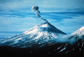
Mount Pavlof or Pavlof Volcano is a stratovolcano of the Aleutian Range on the Alaska Peninsula. It has been one of the most active volcanoes in the United States since 1980, with eruptions recorded in 1980, 1981, 1983, 1986–1988, 1996–1997, 2007, 2013, twice in 2014, 2016, and is currently erupting as of August 2021. Basaltic andesite with SiO2 around 53% is the most common lava type. The volcano is monitored by the Alaska Volcano Observatory- a joint program of the United States Geological Survey (USGS), the Geophysical Institute of the University of Alaska Fairbanks (UAFGI), and the State of Alaska Division of Geological and Geophysical Surveys (ADGGS). With a threat score of 95, the threat from future eruptions is considered to be high; much of this threat comes from the possibility of disruption of nearby air routes by large releases of ash. The mountain currently has basic real-time monitoring, but the USGS would like to improve instrumentation at the site. The mountain shares a name with the nearby Pavlof Sister, which last erupted in 1786.

<span class="mw-page-title-main">Bogoslof Island</span> Volcanic island in the U.S. state of Alaska

Bogoslof Island or Agasagook Island is the summit of a submarine stratovolcano at the south edge of the Bering Sea, 35 miles (56 km) northwest of Unalaska Island of the Aleutian Islands chain. It has a land area of 319.3 acres (1.292 km2) and is uninhabited. It is 1,040 meters (3,410 ft) long and 1,512 m (4,961 ft) wide, with a peak elevation of 490 feet (150 m). The stratovolcano rises about 6,000 ft (1,800 m) from the seabed, but the summit is the only part that projects above sea level. The island is believed to be relatively new, with the volcano being entirely below sea level before 1796, and most of the presently 300-acre island being formed by eruptions since 1900.

<span class="mw-page-title-main">Mount Cleveland (Alaska)</span> Nearly symmetrical stratovolcano on Chuginadak island

Mount Cleveland is a nearly symmetrical stratovolcano on the western end of Chuginadak Island, which is part of the Islands of Four Mountains just west of Umnak Island in the Fox Islands of the Aleutian Islands of Alaska. Mt. Cleveland is 5,675 ft (1,730 m) high, and one of the most active of the 75 or more volcanoes in the larger Aleutian Arc. Aleutian natives named the island after their fire goddess, Chuginadak, who they believed inhabited the volcano. In 1894 a team from the United States Coast and Geodetic Survey visited the island and gave Mount Cleveland its current name, after then-president Grover Cleveland.

<span class="mw-page-title-main">Frosty Peak Volcano</span> Volcano in Alaska, United States

Frosty Peak Volcano, also known as Mt. Frosty, Frosty Volcano, or Cold Bay Volcano, is a 6,299 ft (1,920 m) stratovolcano at the southwest end of the Alaska Peninsula in the U.S. state of Alaska.

<span class="mw-page-title-main">Korovin Volcano</span> Volcano in the U.S. state of Alaska

Korovin Volcano is one of four volcanic centers of the Atka Volcanic Complex, located near the town of Atka on the northeast part of Atka Island in the Aleutian Islands chain, Alaska, United States. At 5,030 feet (1,530 m), Korovin is the highest point on the island.

<span class="mw-page-title-main">Lava lake</span> Molten lava contained in a volcanic crater

Lava lakes are large volumes of molten lava, usually basaltic, contained in a volcanic vent, crater, or broad depression. The term is used to describe both lava lakes that are wholly or partly molten and those that are solidified.

References

  1. "Capital – Historic eruptions". www.avo.alaska.edu. Retrieved June 8, 2018.
  2. "Cleveland – Introduction".
  3. "USGS DDS-40, Volcanoes of the Alaska Peninsula and Aleutian Islands – Album". pubs.usgs.gov. Retrieved June 13, 2018.
  4. "gilbert – Introduction". avo.alaska.edu. Retrieved June 13, 2018.
  5. "Global Volcanism Program | Kialagvik". volcano.si.edu. Retrieved June 14, 2018.
  6. "Global Volcanism Program | Kukak". volcano.si.edu. Retrieved June 14, 2018.
  7. "Westdahl Peak description and information". www.avo.alaska.edu. Retrieved June 17, 2018.
  8. "Roundtop – Historic eruptions". www.avo.alaska.edu. Retrieved June 17, 2018.
  9. "Global Volcanism Program | Sergief". volcano.si.edu. Retrieved June 17, 2018.
  10. "Wide Bay cone – Introduction". www.avo.alaska.edu. Retrieved June 17, 2018.
  11. Jicha, Brian; Coombs, Michelle; T. Calvert, Andrew; Singer, Brad (May 1, 2012). "Geology and 40Ar/39Ar geochronology of the medium- to high-K Tanaga volcanic cluster, western Aleutians". Geological Society of America Bulletin. 124 (5–6): 842–856. Bibcode:2012GSAB..124..842J. doi:10.1130/B30472.1.
  12. "Tana". www.volcanodiscovery.com. Retrieved June 17, 2018.
  13. "Global Volcanism Program | Tlevak Strait-Suemez Is". volcano.si.edu. Retrieved June 17, 2018.
  14. Richter, D. H.; Moll-Stalcup, E. J.; Miller, T. P.; Lanphere, M. A.; Dalrymple, G. B.; Smith, R. L. (March 1994). "Eruptive history and petrology of Mount Drum volcano, Wrangell Mountains, Alaska". Bulletin of Volcanology. 56 (1): 29–46. Bibcode:1994BVol...56...29R. doi:10.1007/bf00279727. ISSN   0258-8900. S2CID   128820426.
  15. Harris, Ann G.; Tittle, Esther; Tittle, Sherwood D. (2004). Geology of National Parks. Kendall Hunt. ISBN   9780787299705.
  16. "Global Volcanism Program | Tutuila". Smithsonian Institution | Global Volcanism Program. Retrieved September 11, 2023.
  17. "San Francisco Peaks Geology". www.snowbowl.ski. Retrieved August 15, 2018.
  18. Muffler, L.J. Patrick; Clynne, Michael A. (2015). "Geologic Field-Trip Guide to Lassen Volcanic National Park and Vicinity, California" (PDF). United States Geological Survey. p. 21. Retrieved July 8, 2018.
  19. McKINNEY, JOHN (March 25, 2001). "Exploring Volcanic Remnants in the Bay Area" via LA Times.
  20. "Global Volcanism Program | Tumble Buttes". volcano.si.edu. Retrieved June 29, 2018.
  21. 1 2 "Yellowstone". Global Volcanism Program . Smithsonian Institution . Retrieved December 31, 2008.
  22. "Illinois State Geological Survey Formation of Hicks Dome in Southern Illinois | ISGS".
  23. "Latent Thermal Effects from Porcupine Volcanic Calderas Underlying the White Pine Straitform Copper Mineralization)". www.researchgate.net. Retrieved September 5, 2019.
  24. https://files.nc.gov/ncdeq/Energy%20Mineral%20and%20Land%20Resources/Geological%20Survey/informationcirculars/Geologic_Adventure_along_the_Eno_River_IC35.pdf
  25. https://sites.radford.edu/~fldsch/RUFieldschool/formationpages/Mt.%20Rogers%20Fm/MtRogers.html
  26. "Global Volcanism Program – Hood".