List of geographic centers of the United States

Last updated

This is a list of geographic centers of each U.S. state and inhabited territory. The geographic center of the United States is northeast of Belle Fourche in Butte County, South Dakota ( 44°58′N103°46′W / 44.967°N 103.767°W / 44.967; -103.767 ), [1] while that of the contiguous 48 states is near Lebanon in Smith County, Kansas ( 39°50′N98°35′W / 39.833°N 98.583°W / 39.833; -98.583 (Geographic Center of the Contiguous United States) ). [1] The geographic center of North America lies near Rugby, North Dakota ( 48°10′N100°10′W / 48.167°N 100.167°W / 48.167; -100.167 ), though this designation has no official status. [1] In 2017, a new calculation of the geographic center of North America placed it near the town of Center, North Dakota. [2]

Contents

Historic list of geographic centers

The list given below has been only slightly modified since it was first produced by the U.S. Geological Survey (USGS) in the early 1920s. [3] At that time, the center for a state was found by suspending a cardboard cutout of the state by a string, and then drawing a vertical line from the suspension point. After rotating the cutout 90 degrees and drawing another vertical line from the new suspension point, the intersection of the two vertical lines was used as the geographic center. [4] The result is dependent upon the type of projection used.

Geographic centers of the states of the United States and the District of Columbia
State or
federal district
CountyLocationCoordinates
Flag of Alabama.svg  Alabama Chilton County Clanton 32°50′5″N86°38′0″W / 32.83472°N 86.63333°W / 32.83472; -86.63333 (Center of Alabama)
Flag of Alaska.svg  Alaska Yukon–Koyukuk Census Area Tanana 64°43′54″N152°28′12″W / 64.73167°N 152.47000°W / 64.73167; -152.47000 (Center of Alaska)
Flag of Arizona.svg  Arizona Yavapai County Camp Verde 34°34′00″N111°51′22″W / 34.56667°N 111.85611°W / 34.56667; -111.85611 (State of Arizona)
Flag of Arkansas.svg  Arkansas Saline County Bryant 34°38′09″N92°28′42″W / 34.6358°N 92.4783°W / 34.6358; -92.4783 (Geographic Center of Arkansas Marker)
Flag of California.svg  California Madera County North Fork 37°9′58″N119°26′58″W / 37.16611°N 119.44944°W / 37.16611; -119.44944 (Center of California)
Flag of Colorado.svg  Colorado Park County 40 mi (64 km) west of Colorado Springs, southwest of Castle Rock 39°00′00″N105°32′42.6″W / 39.00000°N 105.545167°W / 39.00000; -105.545167 (State of Colorado)
Flag of Connecticut.svg  Connecticut Hartford County Berlin
Flag of Delaware.svg  Delaware Kent County 11 mi (18 km) southwest of Dover 38°58′48″N75°30′42″W / 38.98000°N 75.51167°W / 38.98000; -75.51167 (approximate center of Delaware)
Flag of the District of Columbia.svg  District of Columbia District of Columbia [note 1] Near 4th and L Streets, Northwest 38°54′15″N77°00′58″W / 38.90417°N 77.01611°W / 38.90417; -77.01611 (approximate center of District of Columbia)
Flag of Florida.svg  Florida Hernando County 12 mi (19 km) north-northwest of Brooksville 28°40′53″N82°27′36″W / 28.68139°N 82.46000°W / 28.68139; -82.46000 (approximate center of Florida)
Flag of Georgia (U.S. state).svg Georgia Twiggs County 18 mi (29 km) southeast of Macon 32°39′43.6″N83°26′17.9″W / 32.662111°N 83.438306°W / 32.662111; -83.438306 (approximate center of Georgia) [5]
Flag of Hawaii.svg  Hawaii Maui County off-shore southwest of Molokai and west of Lanai
Flag of Idaho.svg  Idaho Custer County on the Yankee Fork River, southwest of Challis 44°16′11″N114°44′04″W / 44.26972°N 114.73444°W / 44.26972; -114.73444 (State of Idaho)
Flag of Illinois.svg  Illinois Sangamon County 1.5 mi (2.4 km) southeast of Rochester 39°44′21.5″N89°30′13.1″W / 39.739306°N 89.503639°W / 39.739306; -89.503639 (approximate center of Illinois)
Flag of Indiana.svg  Indiana Hendricks County 2 mi (3.2 km) west of Avon 39°45′57.7″N86°26′28.6″W / 39.766028°N 86.441278°W / 39.766028; -86.441278 (approximate center of Indiana)
Flag of Iowa.svg  Iowa Story County 5 mi (8.0 km) northeast of Ames
Flag of Kansas.svg  Kansas Barton County 15 mi (24 km) northeast of Great Bend
Flag of Kentucky.svg  Kentucky Marion County 3 mi (4.8 km) north-northwest of Lebanon
Flag of Louisiana.svg  Louisiana Avoyelles Parish 3 mi (4.8 km) southeast of Marksville
Flag of Maine.svg  Maine Piscataquis County 18 mi (29 km) north of Dover-Foxcroft 45°15′11.9982″N69°13′59.9988″W / 45.253332833°N 69.233333000°W / 45.253332833; -69.233333000 (Center of Maine)
Flag of Maryland.svg  Maryland Prince George's County 4.5 mi (7.2 km) northwest of Davidsonville
Flag of Massachusetts.svg  Massachusetts Worcester County 12 mi (19 km) northwest of Worcester, in Rutland 42°22′37.62″N71°55′30.93″W / 42.3771167°N 71.9252583°W / 42.3771167; -71.9252583 (Center of Massachusetts)
Flag of Michigan.svg  Michigan Wexford County 5 mi (8.0 km) north-northwest of Cadillac
Flag of Minnesota.svg  Minnesota Crow Wing County 10 mi (16 km) southwest of Brainerd
Flag of Mississippi.svg  Mississippi Leake County 9 mi (14 km) west-northwest of Carthage
Flag of Missouri.svg  Missouri Miller County 20 mi (32 km) southwest of Jefferson City 38°29′7″N91°22′51″W / 38.48528°N 91.38083°W / 38.48528; -91.38083 (Center of Missouri)
Flag of Montana.svg  Montana Fergus County 11 mi (18 km) west of Lewistown 47°03′52″N109°40′01″W / 47.06444°N 109.66694°W / 47.06444; -109.66694 (State of Montana)
Flag of Nebraska.svg  Nebraska Custer County 10 mi (16 km) northwest of Broken Bow 41°31′30″N99°51′42″W / 41.52500°N 99.86167°W / 41.52500; -99.86167 (approximate center of Nebraska)
Flag of Nevada.svg  Nevada Lander County 26 mi (42 km) southeast of Austin
Flag of New Hampshire.svg  New Hampshire Belknap County 3 mi (4.8 km) east of Ashland 43°41′6″N71°34′38″W / 43.68500°N 71.57722°W / 43.68500; -71.57722 (Approximate center of New Hampshire)
Flag of New Jersey.svg  New Jersey Burlington County 5 mi (8.0 km) southeast of Trenton 40°4′12″N74°33′30″W / 40.07000°N 74.55833°W / 40.07000; -74.55833 (Center of New Jersey)
Flag of New Mexico.svg  New Mexico Torrance County 12 mi (19 km) south-southwest of Willard 34°26′17″N106°06′44″W / 34.43806°N 106.11222°W / 34.43806; -106.11222 (State of New Mexico)
Flag of New York.svg New York Madison County 26 mi (42 km) southwest of Utica, near Syracuse
Flag of North Carolina.svg  North Carolina Chatham County 10 mi (16 km) northwest of Sanford
Flag of North Dakota.svg  North Dakota Sheridan County 5 mi (8.0 km) southwest of McClusky
Flag of Ohio.svg  Ohio Knox County north-northeast of Columbus, 5.6 mi (9.0 km) southwest of Centerburg
Flag of Oklahoma.svg  Oklahoma Oklahoma County 8 mi (13 km) north of Oklahoma City
Flag of Oregon.svg  Oregon Crook County 25 mi (40 km) south-southeast of Prineville
Flag of Pennsylvania.svg  Pennsylvania Centre County 2.5 mi (4.0 km) southwest of Bellefonte, in State College
Flag of Rhode Island.svg  Rhode Island Kent County 1-mile (1.6 km) south-southwest of Crompton 41°40′18″N71°34′36″W / 41.67167°N 71.57667°W / 41.67167; -71.57667 (Center of Rhode Island)
Flag of South Carolina.svg  South Carolina Richland County 13 mi (21 km) southeast of Columbia 33°50′13″N80°55′30″W / 33.83694°N 80.92500°W / 33.83694; -80.92500 (Center of South Carolina)
Flag of South Dakota.svg  South Dakota Hughes County 8 mi (13 km) northeast of Pierre
Flag of Tennessee.svg  Tennessee Rutherford County 5 mi (8.0 km) northeast of Murfreesboro
Flag of Texas.svg  Texas McCulloch County 15 mi (24 km) northeast of Brady 31°23′29.52″N99°10′14.34″W / 31.3915333°N 99.1706500°W / 31.3915333; -99.1706500 (Center of Texas)
Flag of Utah.svg  Utah Sanpete County 3 mi (4.8 km) north of Manti 39°18′29″N111°38′20″W / 39.30806°N 111.63889°W / 39.30806; -111.63889 (State of Utah)
Flag of Vermont.svg  Vermont Washington County 3 mi (4.8 km) east of Roxbury
Flag of Virginia.svg  Virginia Buckingham County 5 mi (8.0 km) southwest of Buckingham
Flag of Washington.svg Washington Chelan County 10 mi (16 km) west-southwest of Wenatchee
Flag of West Virginia.svg  West Virginia Braxton County 4 mi (6.4 km) east of Sutton
Flag of Wisconsin.svg  Wisconsin Wood County 9 mi (14 km) southeast of Marshfield 44°26′16.00″N90°07′48.67″W / 44.4377778°N 90.1301861°W / 44.4377778; -90.1301861 (Center of Wisconsin)
Flag of Wyoming.svg  Wyoming Fremont County 58 mi (93 km) east-northeast of Lander [6]

43°00′00″N107°32′42.6″W / 43.00000°N 107.545167°W / 43.00000; -107.545167 (Center of Wyoming)

Modern list of geographic centers

Although there have been different definitions offered for the geographic center, an intuitive one, and one used by the USGS, is "the center of gravity of the surface, or that point on which the surface of the area would balance if it were a plane of uniform thickness." [7] An updated list of geographic centers using this definition (which is equivalent to the state's centroid) is given below. It was derived by minimizing the sum of squared great circle distances from all points of land in a state (including islands, but not coastal waters, following the earlier practice of the USGS). It represents a slight improvement over the list originally published. [8]

The geographic center of the contiguous United States, determined in this way, is at 39°50.13′N99°5.45′W / 39.83550°N 99.09083°W / 39.83550; -99.09083 (Geographic center of the Geographic center of the Contiguous United States) ; this is 5.4 miles (8.7 km) from Agra, Kansas, 5.7 miles (9.2 km) from Kensington, Kansas, and 26.9 great circle miles (43.3 km) west of the longstanding designated site near Lebanon, Kansas.

Updated geographic centers of the states of the United States and the District of Columbia
State or
federal district
LocationCoordinates
Flag of Alabama.svg  Alabama 12.1 mi (19.5 km) southwest of Clanton 32°46′46″N86°49′43″W / 32.7794°N 86.8287°W / 32.7794; -86.8287 (Geographic center of the State of Alabama)
Flag of Alaska.svg  Alaska 77.9 mi (125.4 km) northwest of Denali 64°04′07″N152°16′42″W / 64.0685°N 152.2782°W / 64.0685; -152.2782 (Geographic center of the State of Alaska)
Flag of Arizona.svg  Arizona 49.7 mi (80.0 km) east-southeast of Prescott 34°16′28″N111°39′37″W / 34.2744°N 111.6602°W / 34.2744; -111.6602 (Geographic center of the State of Arizona)
Flag of Arkansas.svg  Arkansas 14.2 mi (22.9 km) northwest of Little Rock 34°53′38″N92°26′33″W / 34.8938°N 92.4426°W / 34.8938; -92.4426 (Geographic center of the State of Arkansas)
Flag of California.svg  California 36 mi (58 km) northeast of Madera 37°11′03″N119°28′11″W / 37.1841°N 119.4696°W / 37.1841; -119.4696 (Geographic center of the State of California)
Flag of Colorado.svg  Colorado 29.2 mi (47.0 km) northwest of Pikes Peak 38°59′50″N105°32′52″W / 38.9972°N 105.5478°W / 38.9972; -105.5478 (Geographic center of the State of Colorado)
Flag of Connecticut.svg  Connecticut 1.1 mi (1.8 km) east of East Berlin 41°37′19″N72°43′38″W / 41.6219°N 72.7273°W / 41.6219; -72.7273 (Geographic center of the State of Connecticut)
Flag of Delaware.svg  Delaware 11.7 mi (18.8 km) south of Dover 38°59′23″N75°30′18″W / 38.9896°N 75.5050°W / 38.9896; -75.5050 (Geographic center of the State of Delaware)
Flag of the District of Columbia.svg  District of Columbia Near 3rd and P Streets, Northwest 38°54′36″N77°00′53″W / 38.9101°N 77.0147°W / 38.9101; -77.0147 (Geographic center of the District of Columbia)
Flag of Florida.svg  Florida 5.8 mi (9.3 km) northwest of Brooksville 28°37′50″N82°26′59″W / 28.6305°N 82.4497°W / 28.6305; -82.4497 (Geographic center of the State of Florida)
Flag of Georgia (U.S. state).svg Georgia 17.7 mi (28.5 km) southeast of Macon 32°38′29″N83°26′33″W / 32.6415°N 83.4426°W / 32.6415; -83.4426 (Geographic center of the State of Georgia)
Flag of Hawaii.svg  Hawaii 27.7 mi (44.6 km) off-shore south of Wailea-Makena 20°17′34″N156°22′25″W / 20.2927°N 156.3737°W / 20.2927; -156.3737 (Geographic center of the State of Hawai'i)
Flag of Idaho.svg  Idaho 21.4 mi (34.4 km) west-southwest of Challis 44°21′03″N114°36′47″W / 44.3509°N 114.6130°W / 44.3509; -114.6130 (Geographic center of the State of Idaho)
Flag of Illinois.svg  Illinois 28.8 mi (46.3 km) northeast of Springfield 40°02′30″N89°11′47″W / 40.0417°N 89.1965°W / 40.0417; -89.1965 (Geographic center of the State of Illinois)
Flag of Indiana.svg  Indiana 10.8 mi (17.4 km) northwest of Indianapolis 39°53′39″N86°16′54″W / 39.8942°N 86.2816°W / 39.8942; -86.2816 (Geographic center of the State of Indiana)
Flag of Iowa.svg  Iowa 7 mi (11 km) northeast of Ames 42°04′30″N93°29′46″W / 42.0751°N 93.4960°W / 42.0751; -93.4960 (Geographic center of the State of Iowa)
Flag of Kansas.svg  Kansas 2.1 mi (3.4 km) southeast of Bushton Bend 38°29′37″N98°22′49″W / 38.4937°N 98.3804°W / 38.4937; -98.3804 (Geographic center of the State of Kansas)
Flag of Kentucky.svg  Kentucky 3.4 mi (5.5 km) southwest of Lebanon 37°32′05″N85°18′08″W / 37.5347°N 85.3021°W / 37.5347; -85.3021 (Geographic center of the Commonwealth of Kentucky)
Flag of Louisiana.svg  Louisiana 5.8 mi (9.3 km) southeast of Marksville 31°04′08″N91°59′48″W / 31.0689°N 91.9968°W / 31.0689; -91.9968 (Geographic center of the State of Louisiana)
Flag of Maine.svg  Maine 12.6 mi (20.3 km) north of Dover-Foxcroft 45°22′10″N69°14′34″W / 45.3695°N 69.2428°W / 45.3695; -69.2428 (Geographic center of the State of Maine)
Flag of Maryland.svg  Maryland 3.3 mi (5.3 km) north of Bowie 39°03′18″N76°47′27″W / 39.0550°N 76.7909°W / 39.0550; -76.7909 (Geographic center of the State of Maryland)
Flag of Massachusetts.svg  Massachusetts Irving St. and Wellington St., Worcester 42°15′35″N71°48′30″W / 42.2596°N 71.8083°W / 42.2596; -71.8083 (Geographic center of the Commonwealth of Massachusetts)
Flag of Michigan.svg  Michigan 6.6 mi (10.6 km) west of Cadillac 44°20′48″N85°24′37″W / 44.3467°N 85.4102°W / 44.3467; -85.4102 (Geographic center of the State of Michigan)
Flag of Minnesota.svg  Minnesota 10 mi (16 km) southwest of Brainerd 46°16′51″N94°18′19″W / 46.2807°N 94.3053°W / 46.2807; -94.3053 (Geographic center of the State of Minnesota)
Flag of Mississippi.svg  Mississippi 7.7 mi (12.4 km) west-northwest of Carthage 32°44′11″N89°40′04″W / 32.7364°N 89.6678°W / 32.7364; -89.6678 (Geographic center of the State of Mississippi)
Flag of Missouri.svg  Missouri 21 mi (34 km) southwest of Jefferson City 38°21′24″N92°27′29″W / 38.3566°N 92.4580°W / 38.3566; -92.4580 (Geographic center of the State of Missouri)
Flag of Montana.svg  Montana 10.1 mi (16.3 km) west of Lewistown 47°03′10″N109°38′00″W / 47.0527°N 109.6333°W / 47.0527; -109.6333 (Geographic center of the State of Montana)
Flag of Nebraska.svg  Nebraska 12.3 mi (19.8 km) northwest of Broken Bow 41°32′16″N99°47′42″W / 41.5378°N 99.7951°W / 41.5378; -99.7951 (Geographic center of the State of Nebraska)
Flag of Nevada.svg  Nevada 26 mi (42 km) southeast of Austin 39°19′44″N116°37′52″W / 39.3289°N 116.6312°W / 39.3289; -116.6312 (Geographic center of the State of Nevada)
Flag of New Hampshire.svg  New Hampshire 2.6 mi (4.2 km) east of Ashland 43°40′50″N71°34′52″W / 43.6805°N 71.5811°W / 43.6805; -71.5811 (Geographic center of the State of New Hampshire)
Flag of New Jersey.svg  New Jersey 4.3 mi (6.9 km) southeast of Trenton 40°11′27″N74°40′22″W / 40.1907°N 74.6728°W / 40.1907; -74.6728 (Geographic center of the State of New Jersey)
Flag of New Mexico.svg  New Mexico 13.8 mi (22.2 km) south-southwest of Willard 34°24′26″N106°06′45″W / 34.4071°N 106.1126°W / 34.4071; -106.1126 (Geographic center of the State of New Mexico)
Flag of New York.svg New York 11.5 mi (18.5 km) south-southeast of Oneida 42°57′14″N75°31′36″W / 42.9538°N 75.5268°W / 42.9538; -75.5268 (Geographic center of the State of New York)
Flag of North Carolina.svg  North Carolina 12.7 mi (20.4 km) northwest of Sanford 35°33′21″N79°23′16″W / 35.5557°N 79.3877°W / 35.5557; -79.3877 (Geographic center of the State of North Carolina)
Flag of North Dakota.svg  North Dakota 2.7 mi (4.3 km) southwest of McClusky 47°27′00″N100°27′57″W / 47.4501°N 100.4659°W / 47.4501; -100.4659 (Geographic center of the State of North Dakota)
Flag of Ohio.svg  Ohio 24.9 mi (40.1 km) north-northeast of Columbus 40°17′10″N82°47′37″W / 40.2862°N 82.7937°W / 40.2862; -82.7937 (Geographic center of the State of Ohio)
Flag of Oklahoma.svg  Oklahoma 4.4 mi (7.1 km) south of Edmond 35°35′20″N97°29′39″W / 35.5889°N 97.4943°W / 35.5889; -97.4943 (Geographic center of the State of Oklahoma)
Flag of Oregon.svg  Oregon 29.1 mi (46.8 km) southeast of Prineville 43°56′01″N120°33′30″W / 43.9336°N 120.5583°W / 43.9336; -120.5583 (Geographic center of the State of Oregon)
Flag of Pennsylvania.svg  Pennsylvania 2.7 mi (4.3 km) southwest of Bellefonte, in State College 40°52′41″N77°47′59″W / 40.8781°N 77.7996°W / 40.8781; -77.7996 (Geographic center of the Commonwealth of Pennsylvania)
Flag of Rhode Island.svg  Rhode Island 2.4-mile (3.9 km) west of Crompton, in West Warwick 41°40′34″N71°33′22″W / 41.6762°N 71.5562°W / 41.6762; -71.5562 (Geographic center of the State of Rhode Island)
Flag of South Carolina.svg  South Carolina 9.7 mi (15.6 km) southeast of Columbia 33°55′01″N80°53′47″W / 33.9169°N 80.8964°W / 33.9169; -80.8964 (Geographic center of the State of South Carolina)
Flag of South Dakota.svg  South Dakota 7.9 mi (12.7 km) northeast of Pierre 44°26′39″N100°13′35″W / 44.4443°N 100.2263°W / 44.4443; -100.2263 (Geographic center of the State of South Dakota)
Flag of Tennessee.svg  Tennessee 2.5 mi (4.0 km) northeast of Murfreesboro 35°51′29″N86°21′02″W / 35.8580°N 86.3505°W / 35.8580; -86.3505 (Geographic center of the State of Tennessee)
Flag of Texas.svg  Texas 23.6 mi (38.0 km) north of Brady 31°28′33″N99°19′52″W / 31.4757°N 99.3312°W / 31.4757; -99.3312 (Geographic center of the State of Texas)
Flag of Utah.svg  Utah 3.1 mi (5.0 km) northwest of Manti 39°18′20″N111°40′13″W / 39.3055°N 111.6703°W / 39.3055; -111.6703 (Geographic center of the State of Utah)
Flag of Vermont.svg  Vermont 3.7 mi (6.0 km) southeast of Roxbury 44°04′07″N72°39′57″W / 44.0687°N 72.6658°W / 44.0687; -72.6658 (Geographic center of the State of Vermont)
Flag of Virginia.svg  Virginia 16.6 mi (26.7 km) west of Buckingham 37°31′17″N78°51′13″W / 37.5215°N 78.8537°W / 37.5215; -78.8537 (Geographic center of the Commonwealth of Virginia)
Flag of Washington.svg Washington 7 mi (11 km) west-southwest of Wenatchee 47°22′57″N120°26′50″W / 47.3826°N 120.4472°W / 47.3826; -120.4472 (Geographic center of the State of Washington)
Flag of West Virginia.svg  West Virginia 4.9 mi (7.9 km) east-southeast of Sutton 38°38′27″N80°37′22″W / 38.6409°N 80.6227°W / 38.6409; -80.6227 (Geographic center of the State of West Virginia)
Flag of Wisconsin.svg  Wisconsin 9.3 mi (15.0 km) east-southeast of Marshfield 44°37′27″N89°59′39″W / 44.6243°N 89.9941°W / 44.6243; -89.9941 (Geographic center of the State of Wisconsin)
Flag of Wyoming.svg  Wyoming 60.6 mi (97.5 km) east-northeast of Lander 42°59′45″N107°33′04″W / 42.9957°N 107.5512°W / 42.9957; -107.5512 (Geographic center of the State of Wyoming)

Geographic centers of the U.S. territories

Very little information exists about the geographic centers of the U.S. territories. In a geological survey of all geographic centers in the U.S., the U.S. Department of the Interior did not measure the geographic centers of the U.S. territories. [9] Similarly, the USGS does not include the territories in its list of geographic centers. [1] In terms of each territory’s land area, only one territory, Puerto Rico, has a confirmed geographic center. [10] There are also official geographic centers of territorial exclusive economic zones, though those geographic centers are based on a territory's territorial waters (not land area).

Geographic centers of the U.S. territories
TerritoryCounty-
equivalent
LocationCoordinates
Flag of American Samoa.svg  American Samoa North of
Manu’a District (EEZ)
Eastern District
(Tutuila center)
The geographic center of American Samoa’s exclusive economic zone (EEZ) is located in the Pacific Ocean, about 35.08 miles (56.45 km) northeast of the island of Ta‘ū. [11]
The geographic center of Tutuila (the main island) is about 1.03 miles (1.65 km) southwest of Fagatogo. [12]
13°51′06″S169°03′27″W / 13.8517°S 169.0576°W / -13.8517; -169.0576 (Geographic center of the Exclusive Economic Zone of American Samoa)
(EEZ center)
14°17′24″S170°42′10″W / 14.2901°S 170.7028°W / -14.2901; -170.7028 (Geographic center of Tutuila island, American Samoa)
(Tutuila center)
Flag of Guam.svg  Guam Guam [note 2] The geographic center of Guam’s exclusive economic zone is in the Pacific Ocean, about 73.65 miles (118.53 km) west-southwest of Cocos Island and 76.08 miles (122.45 km) west-southwest of the main island of Guam. [13]
The exact geographic center of the main island of Guam is unknown [14] — it is probably somewhere within the village of Chalan Pago-Ordot, because that is the default center starting point of Guam on Google Maps. [15]
12°58′37″N143°34′53″E / 12.9770°N 143.5814°E / 12.9770; 143.5814 (Geographic center of the Exclusive Economic Zone of Guam)
(Center of EEZ)
13°26′38″N144°46′02″E / 13.4440°N 144.7671°E / 13.4440; 144.7671 (Chalan Pago-Ordot village, Guam))
(Chalan Pago-Ordot)
Flag of the Northern Mariana Islands.svg  Northern Mariana Islands Northern Islands Municipality The geographic center of the Northern Mariana Islands’ exclusive economic zone is in the Pacific Ocean, about 18.33 miles (29.50 km) northeast of the island of Pagan. [16] 18°19′06″N146°01′42″E / 18.3183°N 146.0284°E / 18.3183; 146.0284 (Geographic center of the Exclusive Economic Zone of the Northern Mariana Islands)
(EEZ center)
Flag of Puerto Rico.svg  Puerto Rico Orocovis Municipality The geographic center of Puerto Rico is in the Orocovis Municipality, about 2.58 miles (4.15 km) west of the main town of Orocovis. [10] 18°13′20″N66°25′49″W / 18.2223°N 66.4303°W / 18.2223; -66.4303 (Geometric center of the Commonwealth of Puerto Rico)
Flag of the United States Virgin Islands.svg  U.S. Virgin Islands Between Saint Thomas
and Saint Croix
The exact geographic center of the U.S. Virgin Islands is unknown — the default center starting point for the U.S. Virgin Islands on Google Maps is located in the Caribbean Sea, [15] 18.21 miles (29.30 km) south-southeast of Saint Thomas and 18.31 miles (29.47 km) north of Saint Croix — note that this point is the approximate center of the 3 main islands, not the center of the exclusive economic zone 18°20′N64°54′W / 18.34°N 64.90°W / 18.34; -64.90 (Geometric center of the Virgin Islands of the United States)
Flag of the United States.svg U.S. Minor Outlying Islands [note 3] There is no information about the geographic centers of the islands in the U.S. Minor Outlying Islands (or the U.S. Minor Outlying Islands as a whole).

See also

Notes

  1. The U.S. Census Bureau treats the District of Columbia as a state-equivalent and a county-equivalent for statistical purposes.
  2. All of Guam is counted as one county-equivalent by the U.S. Census Bureau.
  3. Each of the 9 island groups in the U.S. Minor Outlying Islands is counted as a county-equivalent by the U.S. Census Bureau.

Related Research Articles

<span class="mw-page-title-main">Geography of the United States</span>

The term "United States," when used in the geographical sense, refers to the contiguous United States, Alaska, Hawaii, the five insular territories of Puerto Rico, Northern Mariana Islands, U.S. Virgin Islands, Guam, American Samoa, and minor outlying possessions. The United States shares land borders with Canada and Mexico and maritime borders with Russia, Cuba, The Bahamas, and many other countries, mainly in the Caribbeanin addition to Canada and Mexico. The northern border of the United States with Canada is the world's longest bi-national land border.

<span class="mw-page-title-main">Contiguous United States</span> 48 states of the United States apart from Alaska and Hawaii

The contiguous United States consists of the 48 adjoining U.S. states and the District of Columbia of the United States of America in central North America. The term excludes the only two non-contiguous states, which are Alaska and Hawaii, and all other offshore insular areas, such as the U.S. territories of American Samoa, Guam, the Northern Mariana Islands, Puerto Rico, and the U.S. Virgin Islands. The colloquial term "Lower 48" is also used, especially in relation to Alaska.

HMS <i>Challenger</i> (1931) Royal Navy survey ship (1931–1954)

HMS Challenger was a survey ship of the United Kingdom's Royal Navy associated with the discovery of Challenger Deep, the deepest point in the oceans. She was laid down in 1930 at Chatham Dockyard and built in a dry dock, before being moved to Portsmouth for completion and commissioning on 15 March 1932.

<span class="mw-page-title-main">Great Divide Basin</span> Endorheic basin adjoining the Continental Divide in southern Wyoming, USA

The Great Divide Basin or Great Divide Closed Basin is an area of land in the Red Desert of Wyoming where none of the water falling as rain to the ground drains into any ocean, directly or indirectly. It is thus an endorheic basin, one of several in North America that adjoin the Continental Divide. To the south and west of the basin is the Green River watershed, draining to the Gulf of California/Pacific Ocean; to the north and east is the North Platte watershed, draining to the Gulf of Mexico. The basin is very roughly rectangular in shape; the northwest corner is at Oregon Buttes near South Pass, about 40 miles (64 km) southwest of Lander, and the southeast corner is in the Sierra Madre Range near Bridger Pass, about 20 miles (32 km) southwest of Rawlins.

<span class="mw-page-title-main">Kokosing River</span> River in the United States

The Kokosing River (ko-KO-sing) is a tributary of the Walhonding River, 57.2 miles (92.1 km) long, in east-central Ohio in the United States. Via the Walhonding, Muskingum and Ohio Rivers, it is part of the watershed of the Mississippi River, draining an area of 482 square miles (1248 km²). Etymologically, "Kokosing" translates roughly to "River of Little Owls." The Kokosing River rises in Morrow County, northeast of Mount Gilead, and initially flows southwardly. It turns eastwardly near Chesterville and flows through Knox and Coshocton Counties, passing the communities of Mount Vernon, Gambier and Howard. In western Coshocton County the Kokosing joins the Mohican River to form the Walhonding River, about 2 miles (3 km) northwest of Nellie.

<span class="mw-page-title-main">Mineral River</span>

The Mineral River is an 18.7-mile-long (30.1 km) tributary of Lake Superior on the western Upper Peninsula of Michigan in the United States. It flows for its entire length in western Ontonagon County, rising in the Ottawa National Forest and flowing generally northward to meet Lake Superior about 11 miles (18 km) west-southwest of Ontonagon. The United States Board on Geographic Names settled on "Mineral River" as the stream's name in 1976; according to the Geographic Names Information System it has also been known historically as "Beaver Creek".

<span class="mw-page-title-main">Licking River (Ohio)</span> River in US

The Licking River is a tributary of the Muskingum River, about 40 mi (65 km) long, in central Ohio in the United States. Via the Muskingum and Ohio Rivers, it is part of the watershed of the Mississippi River.

<span class="mw-page-title-main">Grays Harbor</span> Estuary in the U.S. state of Washington

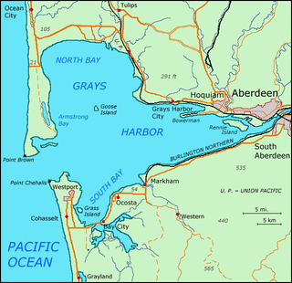
Grays Harbor is an estuarine bay located 45 miles (72 km) north of the mouth of the Columbia River, on the southwest Pacific coast of Washington state, in the United States. It is a ria, which formed at the end of the last ice age, when sea levels flooded the Chehalis River. The bay is 17 miles (27 km) long and 12 miles (19 km) wide. The Chehalis River flows into its eastern end, where the city of Aberdeen stands at that river's mouth, on its north bank, with the somewhat smaller city of Hoquiam immediately to its northwest, along the bayshore. Besides the Chehalis, many lesser rivers and streams flow into Grays Harbor, such as the Hoquiam River and Humptulips River. A pair of low peninsulas separate it from the Pacific Ocean, except for an opening about two miles (3 km) in width. The northern peninsula, which is largely covered by the community of Ocean Shores, ends in Point Brown. Facing that across the bay-mouth is Point Chehalis, at the end of the southern peninsula upon which stands the town of Westport.

Fena Lake (Reservoir) is the largest lake in the United States territory of Guam and it is a man made reservoir. It is located in the south of the island on the Ordnance Annex military installation, and is overlooked by the nearby peaks of Mounts Lamlam, Alifan and Jumullong Manglo. The lake's outflow is to the north-west, its waters eventually reaching the Pacific Ocean at Talofofo Bay.

<span class="mw-page-title-main">Barren River</span> River in Kentucky, United States

The Barren River is a 135-mile-long (217 km) river in Southcentral Kentucky, United States, and a tributary of the Green River. The watershed of the Green River is the largest of the twelve major river watersheds in Kentucky. The Barren River rises near the Tennessee border in Monroe County and flows into the Green in northeast Warren County. The drainage basin consists of Southcentral Kentucky and north-central Tennessee.

In geography, the centroid of the two-dimensional shape of a region of the Earth's surface is known as its geographic centre or geographical centre or gravitational centre. Informally, determining the centroid is often described as finding the point upon which the shape would balance. This method is also sometimes described as the "gravitational method".

<span class="mw-page-title-main">Reserve Township, Parke County, Indiana</span> Township in Indiana, United States

Reserve Township is one of thirteen townships in Parke County, Indiana, United States. As of the 2010 census, its population was 1,423 and it contained 675 housing units.

Old Forge is an unincorporated community in Quincy Township, Franklin County, Pennsylvania, United States, within the Michaux State Forest, at 39°47′40″N77°29′3″W, at altitude of 892 feet (272 m).

<span class="mw-page-title-main">United States Geological Survey</span> Scientific agency of the United States government

The United States Geological Survey (USGS), founded as the Geological Survey, is an agency of the United States government whose work spans the disciplines of biology, geography, geology, and hydrology. The agency was founded on March 3, 1879, to study the landscape of the United States, its natural resources, and the natural hazards that threaten it. The agency also makes maps of extraterrestrial planets and moons based on data from U.S. space probes.

<span class="mw-page-title-main">Geographic center of the United States</span> Central location of the 48 or 50 states

The geographic center of the United States is a point approximately 20 mi (32 km) north of Belle Fourche, South Dakota at 44°58′2.07622″N103°46′17.60283″W. It has been regarded as such by the United States Coast and Geodetic Survey and the U.S. National Geodetic Survey (NGS) since the additions of Alaska and Hawaii to the United States in 1959.

Dru Rock is a rocky island 0.28 kilometres (0.15 nmi) long between Retour Island and Claquebue Island in the Curzon Islands. The island is home to many craggy rock faces, which make climbing difficult.

<span class="mw-page-title-main">Evans Glacier (Graham Land)</span> Glacier in Antarctica

Evans Glacier is a gently-sloping glacier 15 nautical miles (28 km) long and 4 nautical miles (7 km) wide, draining the southeast slopes of Travnik Buttress eastwards between Rugate Ridge and Poibrene Heights to flow into Vaughan Inlet on the east coast of Graham Land, Antarctica. It was discovered by Sir Hubert Wilkins in an aerial flight, December 20, 1928, and named "Evans Inlet" by him for E.S. Evans of Detroit. A further survey by the Falkland Islands Dependencies Survey in 1955 reported that this low-lying area is not an inlet, but is formed by the lower reaches of Hektoria Glacier and the feature now described.

References

  1. 1 2 3 4 https://pubs.usgs.gov/gip/Elevations-Distances/elvadist.html ‘’Elevations and Distances in the United States.’’ USGS. Retrieved June 2019.
  2. https://www.smithsonianmag.com/smart-news/new-calculations-reposition-geographical-center-north-america-1-180961932/ Smithsonian.com. New Calculations Reposition the Geographical Center of North America. Jason Daley. January 30, 2017. Retrieved June 2019.
  3. Douglas, E.M. 1923. Boundaries, Areas, Geographic Centers, and Altitudes of the United States and Several States. Bulletin 689. U.S. Geological Survey, Washington, DC.
  4. Adams, Oscar, S. 1932. Geographical Centers. The Military Engineer 24, 138: 586-587.
  5. A marker, dated 1981, at a nearby road intersection states: "The Geologic Survey Branch of the Department of Natural Resources determined the central point to be at latitude 32° 38' 46" N., longitude 83° 25' 54" W."
  6. "The Geography of Wyoming". Netstate.com. 25 February 2016. Retrieved 9 August 2021.
  7. Van Zandt, Franklin. 1966. Boundaries of the United States and the Several States. Bulletin 1212. U.S. Geological Survey, Washington, DC.
  8. Rogerson, P. 2015. A New Method for Finding Geographic Centers, with Application to the U.S. States. The Professional Geographer. Published online Aug 15, 2015; DOI:10.1080/00330124.2015.1062707 http://www.tandfonline.com/doi/full/10.1080/00330124.2015.1062707#.Vd30QflVhBc Retrieved 2015-08-26
  9. https://pubs.usgs.gov/unnumbered/70039437/report.pdf "Geographic centers of the United States." U.S. Department of the Interior. Retrieved June 2019.
  10. 1 2 http://disfrutaorocovis.com/en/historic-sites-2/geographic-center-of-puerto-rico Disfruta Orocovis. Geographic Center of Puerto Rico. Retrieved June 2019.
  11. http://www.marineregions.org/gazetteer.php?p=details&id=8444 Marineregions.org. Marine Gazetteer Placedetails — American Samoa Exclusive Economic Zone. Retrieved July 3, 2019.
  12. https://www.worldatlas.com/webimage/countrys/oceania/as.htm Worldatlas.com. American Samoa. Retrieved July 3, 2019.
  13. http://www.marineregions.org/gazetteer.php?p=details&id=48957 Marineregions.org. Marine Gazetteer Placedetails. Guam Exclusive Economic Zone. Retrieved June 2019.
  14. https://www.worldatlas.com/webimage/countrys/oceania/gu.htm Worldatlas.com. Guam. Retrieved July 3, 2019.
  15. 1 2 https://www.google.com/maps/place/Guam
    https://www.google.com/maps/place/USVI
    Google Mpas — Guam / U.S. Virgin Islands. Retrieved July 3, 2019.
  16. http://www.marineregions.org/gazetteer.php?p=details&id=48980 Marineregions.org. Marine Gazetteer Placedetails — Northern Mariana Islands Exclusive Economic Zone. Retrieved June 2019.

Works cited