Fagatogo

Last updated
Fagatogo
Village
Line5318 - Flickr - NOAA Photo Library.jpg
Etymology: Samoan: faga ("bay"), togo ("mangrove tree")
Location map American Samoa (central).png
Red pog.svg
Fagatogo
Location in Tutuila Island
American Samoa location map.svg
Red pog.svg
Fagatogo
Fagatogo (American Samoa)
Coordinates: 14°16′45″S170°41′25″W / 14.27917°S 170.69028°W / -14.27917; -170.69028
CountryFlag of the United States.svg  United States
TerritoryFlag of American Samoa.svg  American Samoa
County Maoputasi
Area
  Total2.15 km2 (0.83 sq mi)
Population
 (2010)
  Total1,737
  Density810/km2 (2,100/sq mi)
Demonym(s) Fagatogan [1]
Time zone UTC−11 (Samoa Time Zone)
ZIP code
96799
Area code(s) +1 684

Fagatogo is the downtown area of Pago Pago (the territorial capital of American Samoa). [2] Located in the low grounds at the foot of Matafao Peak, it was the location of the first American settlement on Tutuila Island. It includes the sub-village of Malaloa. [3] Today, Fagatogo is the government, commercial, financial, and shipping center of Tutuila. [4] :1 [5] It is also the administrative capital of American Samoa. [6] It is the location of the American Samoa Fono (legislature), and is listed in the Constitution of American Samoa as the territory's official seat of government. [7] [8] [9] Its population (as of April 1, 2010) is 1,737.

Contents

Fagatogo contains the Pago Pago port, the Pago Pago bus station and market, and the Co-Cathedral of St. Joseph the Worker of the Roman Catholic Diocese of Samoa-Pago Pago. [10] Fagatogo is also home to the governor's mansion, which sits on a hilltop just west of the Rainmaker Hotel site, in a section of Fagatogo called Utulei. This colonial mansion was built in 1903, during the naval administration. The 1917 Jean P. Haydon Museum is located a little further west. The old jail (built in 1911) and the police station sit just across the field from the Fono. [11] The architecture includes both 19th century clapboard buildings and newer, two-story, monotone concrete structures. [12]

The area around Fagatogo Market is considered the center of Pago Pago. Residents from all over the island travel to it by bus. Several landmarks are visible from the market: Mount ʻAlava, the canneries in Atu'u, Rainmaker Mountain (Mount Pioa), and Pago Pago Harbor. [13] Immediately next to the Fagatogo Market is the Fagatogo Square Shopping Center, a 12,000-square-foot retail- and commercial center containing a number of large shops and restaurants. [14] [15] Fagatogo is also home to the Pago Pago post office and the city's taxi services, museums, bars, and movie theaters. [2]

Fagatogo is recognized in American Samoa as having played the paramount role in the territory's political history. For example, it is where every agreement between the United States and American Samoa has been signed. It is jocularly called by some the "Washington, D.C. of American Samoa". [16] :2

Etymology

In the Samoan language, faga translates to “bay”, while togo means “mangrove tree.” A mangrove swamp was located in the village, which stretched from Fagatogo Market to the fuel dock. At the beginning of the 20th century, most mangrove trees had been removed in order to make room for a new wharf and coaling station constructed by the U.S. Naval Administration. [16] :5

History

In Faga Togo, Tutuila, Samoa, Storekeeper's cottage LOC 15048358164.jpg
In Faga Togo, Tutuila, Samoa LOC 15669922472.jpg
U.S. Naval Station Tutuila, c. 1920. American Naval Base, Samoan Islands.png
U.S. Naval Station Tutuila, c. 1920.
High Court of American Samoa. High Court of American Samoa.jpg
High Court of American Samoa.

American interest in Tutuila Island began with the American Samoan Treaty of 1878 which provided the United States with a non-exclusive right to establish a naval station on the Pago Pago Bay. The United States recognized the need to create a naval coaling station on the shipping route between Hawai'i and New Zealand, and shortly after the treaty proceeded to rent land in Pago Pago at $10 a month. In 1889, Rear Admiral L.A. Kimberly USN visited Tutuila and selected a site for a future U.S. naval station. Roughly seventeen acres of land were purchased for a total price of $3,241.79. The construction of the wooden-floored steel dock, storehouse and manager's dwelling did not commerce for another ten years. A water reservoir in the hills behind the station was also constructed, and the expansion of the site begun by filling in Pago Pago Bay to the edge of the fringing reef. The Naval Station was made up of eight shorefront acres as of 1907. The official U.S. Naval Station occupation began by the signing of the Deed of Cession by the High Chiefs on Tutuila- and Aunu'u Islands and the raising of the United States Flag on April 17 in 1900. By the end of the navy administration period in 1951, the Naval Station occupied 216 acres and was made up of 105 structures. As of 2001, only twelve of the structures remained. Most remaining naval structures were entered onto the U.S. National Register of Historic Places in 1988 as a part of the U.S. Naval Station Tutuila Historic District. [4] :2

The naval commandant, ship's crew, and officers all originally lived on board the station ship. A concrete building was built near the station dock in 1902 serving as the first customs house. This structure was replaced by the present-day larger customhouse in 1920, which is located along the waterfront to the southwest of the station dock, known as Navy Building No. 67. This Customhouse, which measures 150 by 80 feet, is located on the waterfront. As with other Naval Station buildings of this period, it was made of locally manufactured concrete blocks molded to imitate rough-cut stone. Until the introduction of the commercial air transportation in 1959, the Customhouse operated as the point-of-entry for all visitors to American Samoa. This was also the site of the territory's only execution, which took place in 1939 when a condemned murderer was hanged here. [4] :4

The front portion of the present-day Jean P. Haydon Museum was originally the Commissary Store, known as Navy Building No. 43, which was erected in 1919. The rear portion of the museum was originally a garage (Navy Building No. 24). When the Department of Interior took over governance of American Samoa in 1951, the commissary in Fagatogo became the Pago Pago Post Office. A new post office was constructed across the William McKinley Memorial Highway in 1971, and the former commissary and garage were consequently converted into a museum, named after the wife of Governor John Morse Haydon. The west wing of the structure was extended in order to add an exhibit space, and a mural in front of the west wing was made by artist Sven Ortquist and depicts a scene from Samoan mythology. A traditional Samoan fale was set up in front of the museum entrance. [4] :4–6

Government House is located between Fagatogo and Utulei. Government house.jpg
Government House is located between Fagatogo and Utulei.

Two 450-foot high radio towers were situated where the present-day Historic District Pedestrian Park is found, near the historic Radio Station known as Navy Building No. 38. This building now serves as the Territorial Registrar's Office and was erected in 1917 during World War I. The structure, which measures 60 square feet, was the first to be built with faux-rock cement blocks. This building was altered in the 1970s in order to accommodate Amerika Samoa Bank. The present-day malae (“Malae o le Talu”), a large grassy area on the south side of the road, serves as the ceremonial center for City of Pago Pago. During the Navy days, it was known as the Parade Ground and was the site of training and performances by the Fita Fita Guard and Band. A small bandshell was found at the far end of the malae. The former Parade Ground, which measures 210 by 500 feet, is now listed on the U.S. National Register of Historic Places and is part of the Naval Station Historic District. [4] :6–7

Present-day Department of Public Safety, which sits across from the malae, is a two-story white structure with an arched Mission Revival-style first-floor veranda. This building was originally erected in 1908 by the Fita Fita Guard and was known was the Fita Fita Barracks (Navy Building No. 31). Immediately west of the former barracks is the former Samoan Jail (Navy Building No. 72), which now serves as offices of Interpol and regional law enforcement agencies OTICIDE and SPICIN. Although it remains unknown when the jail originally was built, it was in existence by 1917 when the United States went to war with Germany. During the war, the commandant seized two German ships in Pago Pago Harbor and detained the crews in the jail. The building is a one-story structure of poured, reinforced concrete, similar to the floor of the Fita Fita Barracks. It measures fifty square feet. [4] :7 and 10

Fagatogo is home to The Fono (legislature). AmericanSamoaLegislatureBuilding.jpg
Fagatogo is home to The Fono (legislature).
A portion of the docks at Fagatogo in Pago Pago Harbor. In the background is the tallest peak on Tutuila, Matafao Peak. PagoPago Harbor NPS.jpg
A portion of the docks at Fagatogo in Pago Pago Harbor. In the background is the tallest peak on Tutuila, Matafao Peak.

Immediately west of the Samoan Jail facing the parade ground is the old Bake Shop, known as Navy Building No. 45. The commandant called for the construction of a new bakery in 1913, claiming the existing bakery was a disgrace to the station and unsanitary. The bakery was therefore constructed in 1919 in this one-story building measuring forty square feet. The present-day building now houses the Samoa Photo Express and Western Union. Further down the main street on the bayside is the Maota Fono complex, now the home of the American Samoa Legislature. The original Fono was across the malae in a former Naval barrack, now home of the Amerika Samoa Bank. When the Fono burned down in 1970, the Fono consequently moved to its new structures in 1973. [4] :10 and 12

Between present-day Scanlan's Inn and T&K General Merchandise is a cement path that leads up to the Catholic Co-Cathedral of St. Joseph the Worker. The cathedral was erected in 1959. A larger white church is situated slightly west of the malae, known as the Congregational Christian Church or Key to the Kingdom of Heaven (“O Le Ki O Le Malo O Le Lagi”). Built on the former location of an older London Missionary Society church, built in 1904. The cornerstone of this church was laid in 1933, but due to construction being interrupted by World War II, the church was not dedicated and completed until 1949. The church went through an extensive two-year renovation in 1994. In front of and slightly to the east is the refurbished High Court Building, originally known as the Naval Station Administration Building or Naval Building No. 21, constructed in 1904. When the structure was restored in 1998 at the cost of $1.2 million, much work was done to replicate the original exterior design and color scheme of the building. Much of the former interior woodwork was also preserved and restored, including the skylight and central staircase. [4] :12–15

Demographics

Congregational Christian Church in Fagatogo Church - panoramio - Peter Gill.jpeg
Congregational Christian Church in Fagatogo

The population is more ethnically diverse than any other village in American Samoa. A majority of the village's residents are Samoans, attributed to the members of original families. Also, immigrants from places such as Western Samoa, the Philippines, Tonga, Fiji, South Korea, Europe, China, and mainland United States are residents of Fagatogo. The village had 1,737 inhabitants as of the 2010 U.S. Census, down from 2,096 which was recorded at the 2000 U.S. Census. Around 85% of the village's residents were under 50 years of age. [16] :2 and 19

From 1980 to 1990, the population of Fagatogo grew from 1,944 to 2,323 inhabitants. The proportion of residents born outside of American Samoa was 23 percent in the early 1980s. This proportion increased to 41 percent between 1985-1990, and the proportion of residents born outside of American Samoa reached 52 percent in 1990. [17]

As of the 2000 U.S. Census, 81.6% of Fagatogo's population were of Native Hawaiian or Other Pacific Island race. 12.5% were Asian, while 3.6% were white. [18]

Religion

Large churches include the Congregational Christian Church in American Samoa (CCCAS) and a Roman Catholic Church. The Methodist Church, Congregational Christian Church in Samoa, and other denominations are present on a smaller scale. [16] :21 Congregational Church of Jesus in Samoa (CCJS)

Economy

Cruise ship Costa Deliziosa at Fagatogo Wharf. IAmerican Samoa 1.JPG
Cruise ship Costa Deliziosa at Fagatogo Wharf.
Sadie Thompson Inn in Malaloa. SADIE THOMPSON BUILDING.jpg
Sadie Thompson Inn in Malaloa.

Fagatogo is the most developed village on Tutuila Island and the center of trade. Most of the village's original families carry on with traditional ways and depend on land and sea for daily needs. Others are employed with the Government of American Samoa or have positions within the legislature, executive or judicial branches. Homes are located on hills and mountain slopes where the land is fertile and ideal for planting fruit trees and vegetables. All types of produce are available at the Fagatogo Market. [16] :21–23

Fagatogo Square houses private businesses and government offices, as well as eateries and shops. [14] This mall is next-door to the Fagatogo Market, which is located in an area known as the center of Pago Pago. It is home to several restaurants, shops, bars, and often live entertainment and music. Souvenirs are often sold at the market when cruise ships are visiting town. Locals also sell handmade crafts at the dock and on the main street. Mount ʻAlava, the canneries in Atu'u, Rainmaker Mountain (Mount Pioa), and Pago Pago Harbor are all visible from the market. The main bus station is located immediately behind the market. [19] [13] The Luman’ai Building houses the Pago Pago Post Office and various business offices. Pago Pago's museum, movie theater, bars, and taxi services are all located in Fagatogo, which is known as Downtown Pago Pago. [2]

Sadie Thompson Inn, which is named for a character in Rain (1921), is also in Fagatogo (Malaloa). This was the site where English author W. Somerset Maugham resided during his visit to Pago Pago in December 1916. [20] It is currently a bed and breakfast inn. It was listed on the U.S. National Register of Historic Places in 2003.

Sports

The Fagatogo Blues Rugby Team has held the main shield for the American Samoa Rugby Union’s Annual Tournament for a number of years. Fagatogo is a regular competitor in the yearly Fautasi Race, held during the Flag Day celebrations and Moso'oi Festival. Female residents established the Fagatogo Teine o le Malaeoletalu cricket team. The team held the championship title in women's cricket for numerous seasons. [16] :19

Places of interest

Notable people

See also

Related Research Articles

Pago Pago Capital city of American Samoa

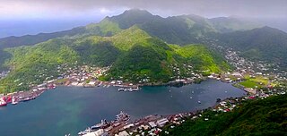
Pago Pago is the territorial capital of American Samoa. It is in Maoputasi County on Tutuila, which is American Samoa's main island.

Tutuila Largest island in American Samoa

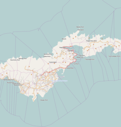
Tutuila is the main island of American Samoa, and is part of the archipelago of Samoan Islands. It is the third largest island in the Samoan Islands chain of the Central Pacific. It is located roughly 4,000 kilometers (2,500 mi) northeast of Brisbane, Australia and lies over 1,200 kilometers (750 mi) to the northeast of Fiji. It contains a large, natural harbor, Pago Pago Harbor, where Pago Pago, the capital of American Samoa, is situated. Pago Pago International Airport is also located on Tutuila. The island’s land expanse is about 68% of the total land area of American Samoa. With 56,000 inhabitants, it is also home to 95% of the population of American Samoa. The island has six terrestrial and three marine ecosystems.

History of American Samoa

The islands of Samoa were originally inhabited by humans as early as 850 BC. After being invaded by European explorers in the 18th century, by the 20th and 21st century, the islands were incorporated into Samoa and American Samoa.

American Samoa Fono Territorial legislature of American Samoa

The American Samoa Fono is the territorial legislature of American Samoa. Like most state and territorial legislatures of the United States, it is a bicameral legislature with a House of Representatives and a Senate. The legislature is located in Fagatogo along Pago Pago harbor.

Poloa is a village in American Samoa. It is located at the west side of Tutuila in the Alataua District. The village has 193 residents in 2010. The main denominations in the area are Methodist and Christian. Poloa has one elementary school. It is located in Lealataua County.

Utulei or ʻUtulei is a village in Maoputasi County, in the Eastern District of Tutuila, the main island of American Samoa. Utulei is traditionally considered to be a section of Fagatogo village, the legislative capital of American Samoa, and is located on the southwest edge of Pago Pago Harbor. Utulei is the site of many local landmarks: The A. P. Lutali Executive Office Building, which is next to the Feleti Barstow Library; paved roads that wind up to a former cablecar terminal on Solo Hill; the governor's mansion, which sits on Mauga o Alii, overlooking the entrance to Goat's Island, and the lieutenant governor's residence directly downhill from it; the Lee Auditorium, built in 1962; American Samoa's television studios, known as the Michael J. Kirwan Educational Television Center; and the Rainmaker Hotel. Utulei Terminal offers views of Rainmaker Mountain.

Eastern District, American Samoa District of American Samoa

The Eastern District is one of the primary districts of American Samoa. It consists of the eastern portion of Tutuila, American Samoa's largest island, plus the island of Aunu'u. The district has a land area of 67.027 km2 and a 2010 census population of 23,030. It contains 34 villages plus a portion of Nu'uuli village. Among these are Pago Pago, Fagatogo, and Utulei.

Leone, American Samoa Village in American Samoa, United States

Leone is the second-largest city on Tutuila Island's west coast. The village is on the south-west coast of Tutuila Island, American Samoa. Leone was the ancient capital of Tutuila Island. Leone was also where the Samoan Islands’ first missionary, John Williams, visited on October 18, 1832. A monument in honor of Williams has been erected in front of Zion Church. Its large church was the first to be built in American Samoa. It has three towers, a carved ceiling and stained glass. Until steamships were invented, Leone was the preferred anchorage of sailing ships which did not risk entering Pago Pago Harbor. Much early contact between Samoans and Europeans took place in Leone.

United States Naval Station Tutuila

United States Naval Station Tutuila was a naval station in Pago Pago Harbor on the island of Tutuila, part of American Samoa, built in 1899 and in operation until 1951. During the United States Navy rule of American Samoa, from 1900 to 1951, it was customary for the commandant of the station to also serve as Military Governor of the territory. Benjamin Franklin Tilley was the first commandant and the first officer responsible for the naval station's construction.

Government House (American Samoa) United States historic place

Government House, also known as Building No.1, Naval Station, Tutuila or Government House, U.S. Naval Station Tutuila, is a historic government building on the grounds of the former United States Naval Station Tutuila in Pago Pago, American Samoa. Built in 1903, it has served as a center of government on the island for much of the time since then. Government House was listed on the United States National Register of Historic Places in 1972, and was declared a National Historic Landmark in 1990.

American Samoa United States territory in the Pacific Ocean

American Samoa is an unincorporated territory of the United States located in the South Pacific Ocean, southeast of the independent state of Samoa. Its location is centered on 14.3°S 170.7°W. It is east of the International Date Line, while Samoa is west of the Line. The total land area is 199 square kilometers (76.8 sq mi), slightly more than Washington, D.C. American Samoa is the southernmost territory of the United States and one of two U.S. territories south of the Equator, along with the uninhabited Jarvis Island. Tuna products are the main exports, and the main trading partner is the rest of the United States.

Afao is a village in southwest Tutuila Island, American Samoa. It is located on the island's short southwestern coast, between 'Amanave and Leone, to the southwest of Pago Pago. It includes the settlement of Atauloma. Afao is home to two places listed on the U.S. National Register of Historic Places: Afao Beach Site and Atauloma Girls School.

Vaitogi is a village in American Samoa. It has many missionaries and tourists who are attracted by shopping for local products. Vaitogi might be most famous of its legends about the Turtle and Shark. It is said that once, at a time when food was scarce, an old woman took her granddaughter to the bluff at Vaitogi, and holding hands, they leaped into the sea down below. While the young girl was transformed into a shark, the blind grandmother became a turtle. It gives its name to a local U-shaped cove in town, which was listed on the U.S. National Register of Historic Places in 2014.

Courthouse of American Samoa United States historic place

The Courthouse of American Samoa, formerly Administration Building, Navy No. 21, is a historic building near Pago Pago Harbor in Fagatogo, American Samoa. It is a two-story wood-frame building mounted on concrete piers, with a two-story veranda on three sides. A concrete vault is located at the back of the building. The court house was reported by the local commander to have been completed about 1904. It housed the offices and other facilities from which the United States Navy administered the island from its construction until 1952, and was where advisory councils of the island's indigenous leaders were held. The building is one of the oldest standing in American Samoa, having survived typhoons and other perils.

Jean P. Haydon Museum United States historic place

The Jean P. Haydon Museum is a museum in Pago Pago dedicated to the culture and history of the United States territory of American Samoa. It contains a collection of canoes, coconut-shell combs, pigs’ tusk armlets and native pharmacopoeia. It also houses exhibits on natural history, tapa making, traditional tattooing, as well as a collection of war clubs, kava bowls, and historic photographs. Constructed in 1913 as U.S. Naval Station Tutuila Commissary, the building was home to Tutuila Island's Post Office from 1950 to 1971. The museum has displays of various aspects of the Samoan Islands’ culture and history. It is the official repository for collections of artifacts for American Samoa. Funded by the American Samoa Council on Arts, Culture and the Humanities, it is the venue used for numerous of the cultural resource activities in American Samoa.

Vailoatai, American Samoa Village in American Samoa, United States

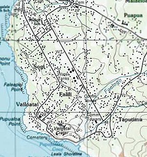
Vailoatai is a village in southwestern Tutuila, the main island of American Samoa. It is located on the eastern end of Leone Bay. The village is known for its beautiful malae located along the island's rugged southern coast, lined by the fale tali mālō of its village chiefs.

Vatia, American Samoa Village in American Samoa, United States

Vatia is a village on Tutuila Island in American Samoa. It is a north shore village located on Vatia Bay. The road to Vatia, American Samoa Highway 006, is the only road going through National Park of American Samoa. Vatia is a scenic community at the foot of Pola Ridge and surrounded by the national park. It is only reached by Route 6 which traverses the national park before reaching Vatia. There was once a hiking trail over Maugaloa Ridge from Leloaloa, but since the completion of Route 6, this trail is now overgrown. It is home to a beach, and panoramic views of jungle-covered peaks surround the village on all sides. Vatia is the center of the Tutuila-section of National Park of American Samoa. It is located in Vaifanua County.

Maʻopūtasi County County in American Samoa ----, United States

Maʻopūtasi County is located in the Eastern District of Tutuila Island in American Samoa. Maʻopūtasi County comprises the capital of Pago Pago and its harbor, as well as surrounding villages. It was home to 11,695 residents as of 2000. Maʻopūtasi County is 6.69 square miles (17.3 km2) The county has a 7.42-mile (11.94 km) shoreline which includes Pago Pago Bay.

Fagasā, American Samoa Village in American Samoa, United States

Fagasā is a village in the Eastern District of Tutuila Island in American Samoa. The village lies by Fagasa Bay, on the north shore of the island. Its name is Samoan and translates to “Forbidden Bay.” The village borders the Tutuila-section of National Park of American Samoa. The trailhead to Mount ‘Alava is located near the village by Fagasa Pass.

Malaloa is a sub-village of Fagatogo and is located at the end of Pago Pago Harbor in American Samoa. It is located in-between Fagatogo proper and the village of Pago Pago. Cruising boats entering and leaving Pago Pago should clear at Malaloa Marina. The Malaloa Marina was opened for cruisers’ use and has added a customs wharf to handle inbound and outbound clearances.

References

  1. Gray, John Alexander Clinton (1980). Amerika Samoa. Arno Press. Page 95. ISBN   9780405130380.
  2. 1 2 3 Grabowski, John F. (1992). U.S. Territories and Possessions (State Report Series). Chelsea House Pub. Page 51. ISBN   9780791010532.
  3. Krämer, Augustin (2000). The Samoa Islands. University of Hawaii Press. Page 440. ISBN   9780824822194.
  4. 1 2 3 4 5 6 7 8 Enright, John (2001). A Walking Tour of Historic Fagatogo: Tutuila, American Samoa. American Samoa Historic Preservation Office.
  5. Leib, Amos Patten (1972). The Many Islands of Polynesia. Schuster Merchandise &. Page 61. ISBN   9780684130101.
  6. Lansford, Tom (2019). Political Handbook of the World 2018-2019. CQ Press. Page 1730. ISBN   9781544327112.
  7. "Revised Constitution of American Samoa". asbar.org. Archived from the original on June 7, 2007. Retrieved November 24, 2010.
  8. Districts of American, statoids.com, retrieved 2008-04-26
  9. Explanation of Listings: Country overview, statoids.com, retrieved 2008-04-26 (See the discussion, "What is the capital of X?")
  10. "Co-Cathedral of St. Joseph the Worker". Giga Catholic. Retrieved 2013-05-21.
  11. Stanley, David (1999). South Pacific Handbook. David Stanley. Page 443. ISBN   9781566911726.
  12. Stuart, Peter C. (1999). Isles of Empire: the United States and its Overseas Possessions. University Press of America. Page 54. ISBN   9780761813118.
  13. 1 2 Stanley, David (1999). Moon Handbooks Tonga-Samoa. David Stanley. Page 168. ISBN   9781566911740.
  14. 1 2 "Pago Pago".
  15. Goodwin, Bill (2006). Frommer’s South Pacific. Wiley. Page 405. ISBN   9780471769804.
  16. 1 2 3 4 5 6 Fai’ivae, Alex Godinet (2018). Ole Manuō o Tala Tu’u Ma Fisaga o Tala Ave. Amerika Samoa Humanities Council. ISBN   9781546229070.
  17. http://www.botany.hawaii.edu/basch/uhnpscesu/pdfs/sam/Pedersen2000vol2AS.pdf (Page 24-22)
  18. Census of population and housing (2000): American Samoa Summary Social, Economic, and Housing Characteristics (2000). DIANE Publishing. Page 147. ISBN   9781428985490.
  19. "Fagatogo Market | American Samoa Attractions".
  20. Rogal, Samuel J. (1997). A William Somerset Maugham Encyclopedia. Greenwood Publishing Group. Page 244. ISBN   9780313299162.

Coordinates: 14°16′57″S170°41′24″W / 14.28250°S 170.69000°W / -14.28250; -170.69000