
Samoa, officially the Independent State of Samoa and until 1997 known as Western Samoa, is a Polynesian island country consisting of two main islands ; two smaller, inhabited islands ; and several smaller, uninhabited islands, including the Aleipata Islands. Samoa is located 64 km (40 mi) west of American Samoa, 889 km (552 mi) northeast of Tonga, 1,152 km (716 mi) northeast of Fiji, 483 km (300 mi) east of Wallis and Futuna, 1,151 km (715 mi) southeast of Tuvalu, 519 km (322 mi) south of Tokelau, 4,190 km (2,600 mi) southwest of Hawaii, and 610 km (380 mi) northwest of Niue. The capital and largest city is Apia. The Lapita people discovered and settled the Samoan Islands around 3,500 years ago. They developed a Samoan language and Samoan cultural identity.
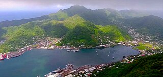
Pago Pago is the capital of American Samoa. It is in Maoputasi County on Tutuila, which is American Samoa's main island.

Territories of the United States are sub-national administrative divisions overseen by the federal government of the United States. The various American territories differ from the U.S. states and Indian reservations as they are not sovereign entities. In contrast, each state has a sovereignty separate from that of the federal government and each federally recognized Native American tribe possesses limited tribal sovereignty as a "dependent sovereign nation." Territories are classified by incorporation and whether they have an "organized" government through an organic act passed by the Congress. American territories are under American sovereignty and, consequently, may be treated as part of the United States proper in some ways and not others. Unincorporated territories in particular are not considered to be integral parts of the United States, and the Constitution of the United States applies only partially in those territories.

Tafuna is a village in Tualauta County, Western District, American Samoa. It is the most populous village in American Samoa, with a population of 7,988 according to the 2020 U.S. Census, and is the center of nightlife on island.
Pagai is a village on the southeast coast of Tutuila Island, American Samoa. It is located on the edge of Faga'itua Bay, and in between the villages of Faga'itua and Alofau. Pagai is six miles east of Pago Pago.

American Samoa is an unincorporated territory of the United States located in the South Pacific Ocean, southeast of the island country of Samoa. Centered on 14.3°S 170.7°W, it is east of the International Date Line and the Wallis and Futuna Islands, west of the Cook Islands, north of Tonga, and some 500 kilometers (310 mi) south of Tokelau. American Samoa is the southernmost territory of the United States and one of two U.S. territories south of the Equator, along with the uninhabited Jarvis Island.

The Catholic Church in Samoa is part of the worldwide Catholic Church, which, initiated by the life, death and resurrection of Jesus Christ, and under the spiritual leadership of the Pope and Roman curia in the Vatican City is the largest Christian church in the world. Catholic missionaries arrived in Samoa in 1845 and today Catholics account for around 20% of the overall population. Archbishop Alapati Lui Mataeliga was ordained as head of the Archdiocese of Samoa-Apia in 2003.

Āfono is a village on the northeast coast of Tutuila Island, American Samoa. One of the island's more populous villages, it is located on the edge of Afono Bay, at the eastern edge of the National Park of American Samoa. It is connected by Highway 6 to Vatia, which lies along the coast to the northwest, and to Aua, on the edge of Pago Pago Harbor to the south via a winding stretch of highway which crosses the spine of the island.

The District of Columbia and United States Territories quarters were a series of six quarters minted by the United States Mint in 2009 to honor the District of Columbia and the unincorporated United States insular areas of Puerto Rico, Guam, the United States Virgin Islands, American Samoa, and the Northern Mariana Islands. The islands commonly grouped together as the United States Minor Outlying Islands were not featured, as the law defined the word "territory" as being limited to the areas mentioned above. They followed the completion of the 50 State Quarters Program. The coins used the same George Washington obverse as with the quarters of the previous 10 years. The reverse of the quarters featured a design selected by the Mint depicting the federal district and each territory. Unlike on the 50 State quarters, the motto "E Pluribus Unum" preceded and was the same size as the mint date on the reverse.
ʻIliʻili is a village in the southwest of Tutuila Island, American Samoa. It is located seven miles inland, southwest of Pago Pago, between the villages of Futiga and Vaitogi. It is in Tuālāuta County.
Aʻasu or Āsu is a village on the north coast of Tutuila Island, American Samoa. It is located to the west of Fagasa and northwest of Pago Pago. It is one of multiple villages involved in an archaeological survey of the island. Aʻasu lies on Massacre Bay and can be reached from a hiking trail in Aʻasufou. Massacre Bay can be visited by car, aiga buses, or through excursions offered by North Shore Tours.
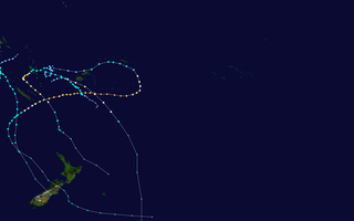
The 2017–18 South Pacific cyclone season was a slightly below-average season that produced 6 tropical cyclones, 3 of which became severe tropical cyclones. The season officially began on November 1, 2017, and ended on April 30, 2018; however, a tropical cyclone could form at any time between July 1, 2017, and June 30, 2018, and would count towards the season total. During the season, tropical cyclones were officially monitored by the Fiji Meteorological Service, MetService and the Australian Bureau of Meteorology, while the United States Joint Typhoon Warning Center (JTWC) also monitored the basin and issued warnings for American interests. The FMS attaches a number and an F suffix to significant tropical disturbances that form in or move into the basin, while the JTWC designates significant tropical cyclones with a number and a P suffix. The BoM, FMS and MetService all use the Australian Tropical Cyclone Intensity Scale and estimate wind speeds over a period of ten minutes, while the JTWC estimates sustained winds over a 1-minute period, which are subsequently compared to the Saffir–Simpson hurricane wind scale (SSHWS).
The Samoa national under-17 football team is the national U-17 team of Samoa and is controlled by Football Federation Samoa.
The geology of American Samoa is part of the broader geology of the Samoan island chain.
Lauliʻi is a village on the eastern side of Tutuila Island in American Samoa. It is located in Sua County. Entering the village of Lauliʻi, one has to climb a small hill where a lighthouse is located. The village's rugby club is named after the lighthouse — Moli ole Ava. It is one of the most successful and oldest clubs in the territory. Many well-known players have emerged from Lauliʻi, such as Vui Eli Tagaloa, the current coach, Ropeti Taula, and others. The village is divided into two sections: Lauliʻituai and Lauliʻifou .As of Late 2020 there are 6 Christian Worship Churches in Lauliʻi. The Methodist, The Catholic, The London Missionary Society, Church, Assembly of God, Church of Christ Latter Day Saints Lauliʻi Ward, Saint John's Episcopal Church. Breakers Point Naval Guns, which is listed on the U.S. National Register of Historic Places is located at Tafananai near Lauliʻifou.

Tropical cyclones regularly affect the coastlines of most of Earth's major bodies of water along the Atlantic, Pacific, and Indian oceans. Also known as hurricanes, typhoons, or other names, tropical cyclones have caused significant destruction and loss of human life, resulting in about 2 million deaths since the 19th century. Powerful cyclones that make landfall – moving from the ocean to over land – are some of the most impactful, although that is not always the case. An average of 86 tropical cyclones of tropical storm intensity form annually worldwide, with 47 reaching hurricane/typhoon strength, and 20 becoming intense tropical cyclones, super typhoons, or major hurricanes.

