
The Samoan Islands are an archipelago covering 3,030 km2 (1,170 sq mi) in the central South Pacific, forming part of Polynesia and of the wider region of Oceania. Administratively, the archipelago comprises all of the Independent State of Samoa and most of American Samoa. The land masses of the two Samoan jurisdictions are separated by 64 km (40 mi) of ocean at their closest points.
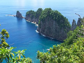
The National Park of American Samoa is a national park in the United States territory of American Samoa, distributed across four islands: Tutuila, Ofu, Olosega, and Ta‘ū. The park preserves and protects coral reefs, tropical rainforests, fruit bats, and the Samoan culture. Popular activities include hiking and snorkeling. Of the park's 8,257 acres (3,341 ha), 2,500 acres (1,000 ha) is coral reefs and ocean. The park is the only American National Park Service system unit south of the equator.

Taʻū is the largest inhabited island in the Manuʻa Islands and the easternmost volcanic island of the Samoan Islands. Taʻū is part of American Samoa. In the early 19th century, the island was sometimes called Opoun.
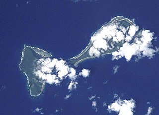
Ofu and Olosega are parts of a volcanic doublet in the Manuʻa Islands, which is a part of American Samoa in the Samoan Islands. These twin islands, formed from shield volcanoes, have a combined length of 6 km and a combined area of 12 square kilometers. Together, they have a population of about 500 people. Geographically, the islands are volcanic remnants separated by the narrow, 137-meter-wide (449-foot)) Āsaga Strait, composed of shallow-water coral reef. Before 1970, people crossed between the two islands by waiting until low tide and then wading across the shallow water of the strait. Since 1970, there has been a bridge over the strait, providing a single-lane road that connects the two islands.

The Tripartite Convention of 1899 concluded the Second Samoan Civil War, resulting in the formal partition of the Samoan archipelago into a German colony and a United States territory.

The Manuʻa Islands, or the Manuʻa tele, in the Samoan Islands, consists of three main islands: Taʻū, Ofu and Olosega. The latter two are separated only by the shallow, 137-meter-wide Āsaga Strait, and are now connected by a bridge over the strait. The islands are located some 110 kilometers east of Tutuila and are a part of American Samoa, an unincorporated territory of the United States. Their combined area is 56 square kilometers, and they have a total population of 1,400. Taʻu is the largest of these islands, with an area of 44 km2 (17 sq mi), and it has the highest point of the Manuʻa, at 931 meters. Politically, the islands form the Manuʻa District, one of the three administrative divisions of American Samoa.

Tui Manuʻa Elisara was the last Tui Manu'a titleholder in Manu'a, which is now part of the U.S. Territory of American Samoa. Elisala was the son of Tui Manuʻa Alalamua whose genealogy descended from the Sa Tagaloa.
The islands of Samoa were originally inhabited by humans as early as 850 BC. After being invaded by European explorers in the 18th century, by the 20th and 21st century, the islands were incorporated into Samoa and American Samoa.

The American Samoa Fono is the territorial legislature of American Samoa. Like most states and territorial legislatures of the United States, it is a bicameral legislature with a House of Representatives and a Senate. The legislature is located in Fagatogo along Pago Pago harbor.
The American Samoa House of Representatives is the lower house of the American Samoa Fono. The House consists of 21 members serving two-year terms, with 20 popularly elected representatives, and one delegate from Swains Island elected in a public meeting.
The American Samoa Senate is the upper house of the American Samoa Fono. The Senate, like the lower House of Representatives, is a nonpartisan body. It is composed of 18 senators, serving a four-year term.

The Eastern District is one of the primary districts of American Samoa. It consists of the eastern portion of Tutuila, American Samoa's largest island, plus the island of Aunu'u. The district has a land area of 67.027 km2 and a 2010 census population of 23,030. It contains 34 villages plus a portion of Nuʻuuli village. Among these are Pago Pago, Fagatogo, and Utulei.
Area code 684 is a telephone area code in the North American Numbering Plan (NANP) for American Samoa. The numbering plan area comprises the seven islands of Tutuila, Aunuʻu, Ofu, Olosega, Taʻū, Swains Island, and Rose Atoll.
Fagali'i or Fagali'i-uta is a village on the island of Upolu in the Samoa archipelago approximately 5 kilometres south-east of Apia. It is in the electoral constituency of Vaimauga East which forms part of the larger political district of Tuamasaga.

The following is an alphabetical list of articles related to the United States Territory of American Samoa.

American Samoa is an unincorporated territory of the United States located in the South Pacific Ocean, southeast of the island country of Samoa. Centered on 14.3°S 170.7°W, it is east of the International Date Line and the Wallis and Futuna Islands, west of the Cook Islands, north of Tonga, and some 500 kilometers (310 mi) south of Tokelau. American Samoa is the southernmost territory of the United States and one of two U.S. territories south of the Equator, along with the uninhabited Jarvis Island.

Āfono is a village on the northeast coast of Tutuila Island, American Samoa. One of the island's more populous villages, it is located on the edge of Afono Bay, at the eastern edge of the National Park of American Samoa. It is connected by Highway 6 to Vatia, which lies along the coast to the northwest, and to Aua, on the edge of Pago Pago Harbor to the south via a winding stretch of highway which crosses the spine of the island.

The title Tui Manuʻa was the title of the ruler or paramount chief of the Manuʻa Islands in present-day American Samoa.
The Manuʻa District is one of the three primary administrative divisions of American Samoa. The district comprises the Manuʻa Islands, which are located approximately 61 miles (98 km) east of the main island, Tutuila. The Manuʻa District is considered to be a county-equivalent by the U.S. Census Bureau.


