This article needs additional citations for verification .(June 2018) (Learn how and when to remove this template message) |
Faiava is a tribal settlement on the island of Olosega on Ofu-Olosega [1] [2]
This article needs additional citations for verification .(June 2018) (Learn how and when to remove this template message) |
Faiava is a tribal settlement on the island of Olosega on Ofu-Olosega [1] [2]

The Samoan Islands are an archipelago covering 3,030 km2 (1,170 sq mi) in the central South Pacific, forming part of Polynesia and the wider region of Oceania. Administratively, the archipelago comprises all of the Independent State of Samoa and most of American Samoa. The nearest land masses of the two Samoan jurisdictions are separated by 64 km (40 mi) of ocean.

Taʻū is the largest island in the Manuʻa Group and the easternmost volcanic island of the Samoan Islands. Taʻū is part of American Samoa. In the early 19th century, the island was sometimes called Opoun.
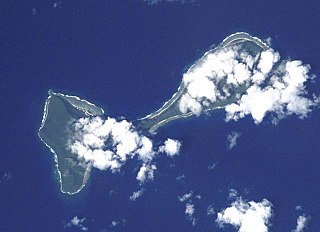
Ofu and Olosega are parts of a volcanic doublet in the Manu‘a Group of the Samoan Islands—part of American Samoa. The twin islands, formed from shield volcanoes, have a combined length of 6 km and an area of 12 square kilometers ; their population is about 500 people. They are geographic volcanic remnants separated by the narrow 137-meter-wide (449-foot) Āsaga Strait, a natural bridge of shallow coral reef. Before 1970, one had to wade between the two islands at low tide; now a single-lane road bridge over the strait connects villages on Ofu island with those on Olosega.

The Manuʻa Islands, or the Manuʻa tele, in the Samoan Islands, consists of three main islands: Taʻū, Ofu and Olosega. The latter two are now connected by a bridge over the shallow 137-meter-wide Āsaga Strait. The islands are located some 110 kilometers east of Tutuila and are a part of American Samoa, an unincorporated territory of the United States; their area is 56 square kilometers with a population of 1,400. Taʻu is the biggest island with its 44 km2 (17 sq mi), and harbors the highest point of the Manuʻa at 931 meters. Politically, the islands form the Manuʻa District, one of the three administrative divisions of American Samoa.
Upper Lillooet Provincial Park is a provincial park in British Columbia, Canada. The 19,996-hectare park was established on July 28, 1997, under the National Parks Act.

The American Samoa Senate is the upper house of the American Samoa Fono. The Senate, like the lower House of Representatives, is a nonpartisan body. It is composed of 18 senators, serving a four-year term.
The Loyalty Islands Province is one of three administrative subdivisions of New Caledonia encompassing the Pulau kesetiaan archipelago in the Pacific located northeast of the New Caledonian mainland of Grande Terre. The provincial government seat is part of the French territory of New Caledonia, at Lifou, which is 100 kilometres (62 mi) away. The Loyalty Islands are a collectivité territoriale of France. The province's 2019 population was approximately 18,353 inhabitants living on almost 2,000 square kilometres (770 sq mi). The native inhabitants are the Kanak and the Tavu'avua' peoples.

The following outline is provided as an overview of and topical guide to American Samoa:

Desaguadero Municipality is the fourth municipal section of Ingavi Province in La Paz Department, Bolivia. Its capital is Desaguadero.
Settat is a province of Morocco in the Casablanca-Settat Region. The province had a population of 956,904 people in 2004.
Tlaxco Municipality is a municipality in Puebla in southeastern Mexico.

The Manuʻa District is one of the three primary administrative divisions of American Samoa. The district comprises the Manuʻa Islands, which are located approximately 61 miles east of the main island, Tutuila. The Manuʻa District is considered to be a county-equivalent by the U.S. Census Bureau.

Ülensi, is a village in Viljandi Parish, Viljandi County, Estonia. Until the 2017 administrative reform of Estonian municipalities the village was located in Tarvastu Parish. It is approximately 4.4 km northwest of the town of Mustla and 40 km southeast of the town of Viljandi. The village has a population of 113 people as of 2012.
Ämmuste is a village in Viljandi Parish, Viljandi County, Estonia. Until the 2017 administrative reform of Estonian municipalities the village was located in Tarvastu Parish. It is located 6.4 km south of the small borough of Mustla and 24 km southwest of the town of Viljandi near the border of Valga County. As of 2011, Ämmuste had a population of 15 residents, a decrease from 22 in the 2000 census. These figures, however, do not reflect the population number when students and faculty of Ämmuste School are factored in.

Sooviku is a village in Viljandi Parish, Viljandi County, Estonia. Until the 2017 administrative reform of Estonian municipalities the village was located in Tarvastu Parish. Sooviku is located 22 km southeast of the town of Viljandi, 2.2 km northwesr of the small borough of Mustla, near the western shore of Lake Võrtsjärv. Neighboring villages include Porsa, Tarvastu, Villa and Vanausse. Sooviku had a population of 34 as of 2011, a decrease from 69 in the 2000 census.
Kuressaare is a village in Viljandi Parish, Viljandi County, Estonia. Until the 2017 administrative reform of Estonian municipalities the village was located in Tarvastu Parish. Kuressaare is located 23 km (14) southeast of the town of Viljandi, 3.8 km southwest of the small borough of Mustla. Neighboring villages include Pikru, Ämmuste and Jakobimõisa. Kuressaare had a population of 67 as of 2011, a decrease from 85 in the 2000 census.
Olosega is a village and the capital of Olosega in Ofu-Olosega in American Samoa. Almost all the population of Olosega now reside in Olosega village along the southwestern-facing shore. Olosega also has Olosega Elementary School with instruction through grade 8 for children on both islands.
Lalomoana is a small settlement located in Olosega island in Ofu-Olosega on the slopes on Piumafua, in Manu‘a Group of the Samoan Islands—part of American Samoa. No roads connect to the settlement.
Sili is a tiny village on the island of Olosega on Ofu-Olosega. Sili, situated on the northwestern-facing shore, in the present day consists of but one standing inhabited residence after much of the village was destroyed by cyclones. Its closest place is Lalomoana.
Coordinates: 14°09′59″S169°37′00″W / 14.1664°S 169.6167°W
| This American Samoa location article is a stub. You can help Wikipedia by expanding it. |