Centerburg, Ohio

Last updated

Centerburg, Ohio
Main in downtown Centerburg, northwestern side.jpg
Main Street downtown
Nicknames: 
The True Heart of Ohio, Douglasland
OHMap-doton-Centerburg.svg
Location of Centerburg, Ohio
Map of Knox County Ohio Highlighting Centerburg Village.png
Location of Centerburg in Knox County
Coordinates: 40°18′14″N82°41′52″W / 40.30389°N 82.69778°W / 40.30389; -82.69778
Country United States
State Ohio
County Knox
Township Hilliar
Area
[1]
  Total0.97 sq mi (2.51 km2)
  Land0.97 sq mi (2.50 km2)
  Water0.00 sq mi (0.01 km2)
Elevation
[2]
1,207 ft (368 m)
Population
 (2020)
  Total1,690
  Density1,747.67/sq mi (674.85/km2)
Time zone UTC-5 (Eastern (EST))
  Summer (DST) UTC-4 (EDT)
ZIP code
43011
Area code(s) 740, 220
FIPS code 39-13036 [3]
GNIS feature ID2397588 [2]
Website www.centerburgoh.org

Centerburg is a village in Knox County, Ohio, United States, along the North Fork of the Licking River. As of the 2020 census, the village population was 1,690. Centerburg is located near the geographical center of Ohio.

Contents

History

Centerburg (formerly rendered Centreburgh) was laid out in 1830. [4] The village was so named on account of its location near Ohio's geographical center. [5] A post office has been in operation at Centerburg since 1835. [6]

Geography

According to the United States Census Bureau, the village has a total area of 0.90 square miles (2.33 km2), all land. [7]

Demographics

Historical population
CensusPop.Note
1880 400
1890 58847.0%
1900 70620.1%
1910 7232.4%
1920 7757.2%
1930 761−1.8%
1940 7792.4%
1950 88713.9%
1960 9638.6%
1970 1,0387.8%
1980 1,27522.8%
1990 1,3233.8%
2000 1,4328.2%
2010 1,77323.8%
2020 1,690−4.7%
U.S. Decennial Census [8]

2010 census

As of the census [9] of 2010, there were 1,773 people, 622 households, and 431 families living in the village. The population density was 1,970.0 inhabitants per square mile (760.6/km2). There were 679 housing units at an average density of 754.4 per square mile (291.3/km2). The racial makeup of the village was 96.9% White, 1.2% African American, 0.1% Native American, 0.3% Asian, 0.1% from other races, and 1.4% from two or more races. Hispanic or Latino of any race were 0.2% of the population.

There were 622 households, of which 42.6% had children under the age of 18 living with them, 46.9% were married couples living together, 16.7% had a female householder with no husband present, 5.6% had a male householder with no wife present, and 30.7% were non-families. 26.4% of all households were made up of individuals, and 12.1% had someone living alone who was 65 years of age or older. The average household size was 2.63 and the average family size was 3.19.

The median age in the village was 36.2 years. 28.5% of residents were under the age of 18; 8.5% were between the ages of 18 and 24; 26% were from 25 to 44; 22.6% were from 45 to 64; and 14.3% were 65 years of age or older. The gender makeup of the village was 47.3% male and 52.7% female.

2000 census

As of the census [3] of 2000, there were 1,432 people, 504 households, and 363 families living in the village. The population density was 2,228.5 inhabitants per square mile (860.4/km2). There were 537 housing units at an average density of 835.7 per square mile (322.7/km2). The racial makeup of the village was 97.91% White, 0.49% African American, 0.35% Native American, 0.28% Asian, 0.07% from other races, and 0.91% from two or more races. Hispanic or Latino of any race were 0.07% of the population.

There were 504 households, out of which 42.7% had children under the age of 18 living with them, 57.1% were married couples living together, 11.5% had a female householder with no husband present, and 27.8% were non-families. 25.6% of all households were made up of individuals, and 11.7% had someone living alone who was 65 years of age or older. The average household size was 2.63 and the average family size was 3.16.

In the village, the population was spread out, with 29.3% under the age of 18, 6.6% from 18 to 24, 30.4% from 25 to 44, 17.6% from 45 to 64, and 16.0% who were 65 years of age or older. The median age was 35 years. For every 100 females there were 100.0 males. For every 100 females age 18 and over, there were 90.2 males.

The median income for a household in the village was $39,750, and the median income for a family was $46,250. Males had a median income of $34,097 versus $27,353 for females. The per capita income for the village was $16,764. About 3.6% of families and 5.6% of the population were below the poverty line, including 5.7% of those under age 18 and 6.3% of those age 65 or over.

Notable people

Related Research Articles

<span class="mw-page-title-main">Aberdeen, Ohio</span> Village in Ohio, United States

Aberdeen is a village in Huntington Township, Brown County, Ohio, United States, along the Ohio River 50 miles (80 km) southeast of Cincinnati. The population was 1,515 at the 2020 census.

<span class="mw-page-title-main">Warsaw, Ohio</span> Village in Ohio, United States

Warsaw is a village in Coshocton County, Ohio, United States, along the Walhonding River. The population was 624 at the 2020 census.

<span class="mw-page-title-main">Lithopolis, Ohio</span> Village in Ohio, United States

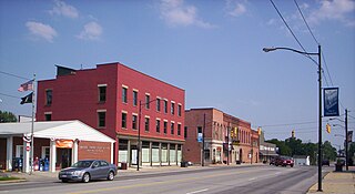
Lithopolis is a village in Fairfield and Franklin counties in the U.S. state of Ohio. The population was 2,134 at the 2020 census.

<span class="mw-page-title-main">Brice, Ohio</span> Village in Ohio, United States

Brice is a village in Franklin County, Ohio, United States, on the southeast side of the Columbus metropolitan area. The population was 93 at the 2020 census.

<span class="mw-page-title-main">Lyons, Ohio</span> Village in Ohio, United States

Lyons is a village in Fulton County, Ohio, United States. The population was 602 at the 2020 census.

<span class="mw-page-title-main">Metamora, Ohio</span> Village in Ohio, United States

Metamora is a village in Fulton County, Ohio, United States. The population was 566 at the 2020 census.

<span class="mw-page-title-main">Cleves, Ohio</span> City in Ohio, United States

Cleves is a village in Miami Township, Hamilton County, Ohio, United States. Located along the Ohio River, it is a western suburb of Cincinnati. The population was 3,414 at the 2020 census.

<span class="mw-page-title-main">Newtown, Ohio</span> Village in Ohio, United States

Newtown is a village in southeastern Hamilton County, Ohio, United States, near Cincinnati. The population was 2,702 at the 2020 census. Newtown was settled in 1792 and incorporated as a village in 1901.

<span class="mw-page-title-main">McGuffey, Ohio</span> Village in Ohio, United States

McGuffey is a village in Hardin County, Ohio, United States. The population was 466 at the 2020 census.

<span class="mw-page-title-main">Monroeville, Ohio</span> Village in Ohio, United States

Monroeville is a village in Huron County, Ohio, United States. The population was 1,300 at the 2020 census.

<span class="mw-page-title-main">Danville, Ohio</span> Village in Ohio, United States

Danville is a village in Knox County, Ohio, United States. The population was 1,019 at the 2020 census.

<span class="mw-page-title-main">Sheffield, Ohio</span> Village in Ohio, United States

Sheffield is a village in Lorain County, Ohio, United States, along the Black River. The population was 4,135 at the 2020 census. It is part of the Cleveland metropolitan area.

<span class="mw-page-title-main">Whitehouse, Ohio</span> Village in Ohio, United States

Whitehouse is a village within the Toledo Metropolitan Area in Lucas County, Ohio, United States. The population was 4,990 at the 2020 census.

<span class="mw-page-title-main">Sparta, Ohio</span> Village in Ohio, United States

Sparta is a village in Morrow County, Ohio, United States. The population was 121 at the 2020 census. Sparta is southeast of Mount Gilead, the county seat.

<span class="mw-page-title-main">Cloverdale, Ohio</span> Village in Ohio, United States

Cloverdale is a village in Perry Township, Putnam County, Ohio, United States. The population was 170 at the 2020 census.

<span class="mw-page-title-main">Limaville, Ohio</span> Census-designated place in Ohio, United States

Limaville is a census-designated place (CDP) and former village in Stark County, Ohio, United States. The population was 151 at the 2020 census. It is part of the Canton–Massillon Metropolitan Statistical Area.

<span class="mw-page-title-main">Port Washington, Ohio</span> Village in Ohio, United States

Port Washington is a village in Tuscarawas County, Ohio, United States. The population was 548 at the 2020 census.

<span class="mw-page-title-main">Apple Creek, Ohio</span> Village in Ohio, United States

Apple Creek is a village in East Union Township, Wayne County, Ohio, United States. The population was 1,188 at the 2020 census.

<span class="mw-page-title-main">Risingsun, Ohio</span> Village in Ohio, United States

Risingsun is a village in Wood County, Ohio, United States. The population was 541 at the 2020 census.

<span class="mw-page-title-main">Gratiot, Ohio</span> Village in Ohio, United States

Gratiot is a village in Licking and Muskingum counties in the U.S. state of Ohio. The population was 215 at the 2020 census.

References

  1. "ArcGIS REST Services Directory". United States Census Bureau. Retrieved September 20, 2022.
  2. 1 2 U.S. Geological Survey Geographic Names Information System: Centerburg, Ohio
  3. 1 2 "U.S. Census website". United States Census Bureau . Retrieved January 31, 2008.
  4. Graham, Albert Adams (1881). History of Knox County, Ohio: Its Past and Present, Containing a Condensed, Comprehensive History of Ohio. A. A. Graham & Company. p. 485.
  5. Dorgan, Howard (1997). In the Hands of a Happy God: The "no-hellers" of Central Appalachia. Univ. of Tennessee Press. p. 157. ISBN   978-0-87049-962-3.
  6. "Knox County". Jim Forte Postal History. Archived from the original on February 24, 2016. Retrieved December 29, 2015.
  7. "US Gazetteer files 2010". United States Census Bureau. Archived from the original on January 25, 2012. Retrieved January 6, 2013.
  8. "Census of Population and Housing". Census.gov. Retrieved June 4, 2015.
  9. "U.S. Census website". United States Census Bureau . Retrieved January 6, 2013.