List of U.S. states and territories by historical population

Last updated

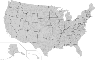
The population growth of each U.S. state from 1970 to 2020.
.mw-parser-output .legend{page-break-inside:avoid;break-inside:avoid-column}.mw-parser-output .legend-color{display:inline-block;min-width:1.25em;height:1.25em;line-height:1.25;margin:1px 0;text-align:center;border:1px solid black;background-color:transparent;color:black}.mw-parser-output .legend-text{}
Population decline
Population growth of less than 24.99%
Population growth of less than 49.99%
Population growth of less than 99.99%
Population growth of less than 149.99%
Population growth of less than 199.99%
Population growth of more than 200.00% USpopgrowth1970-2020.svg
The population growth of each U.S. state from 1970 to 2020.
  Population decline
  Population growth of less than 24.99%
  Population growth of less than 49.99%
  Population growth of less than 99.99%
  Population growth of less than 149.99%
  Population growth of less than 199.99%
  Population growth of more than 200.00%

This is a list of U.S. states and territories by historical population, as enumerated every decade by the United States Census. As required by the United States Constitution, a census has been conducted every 10 years since 1790. Although the decennial census collects a variety of information that has been used in demographic studies, marketing, and other enterprises, the purpose of the census as stated in the Constitution is to produce an "actual enumeration" of the number of persons in the states in order to calculate their Congressional apportionment.

Contents

As the United States has grown in area and population, new states have been formed out of U.S. territories or the division of existing states. The population figures provided here reflect modern state boundaries. Shaded areas of the tables indicate census years when a territory or the part of another state had not yet been admitted as a new state. [lower-alpha 1] Since 1920, the "total population" of the United States has been considered the population of all the States and the District of Columbia; territories and other possessions were counted as additional population. [lower-alpha 2] As of 2021, five U.S. territories (American Samoa, Guam, the Northern Mariana Islands, Puerto Rico and the U.S. Virgin Islands), along with the U.S. Minor Outlying Islands, are not included in the count of total U.S. population.

1790–1860, census data

Total population, 1790–1860

Total population counts for the Censuses of 1790 through 1860 include both free and enslaved persons. Native Americans were not identified in the Census of 1790 through 1840 and only sporadically from 1850 until 1890, if they lived outside of Indian Territory or off reservations. Beginning with the 1900 census, Native Americans were fully enumerated along with the general population. [lower-alpha 3]

Enslaved population, 1790–1860

The below figures cover only people held in bondage. They are also counted in the total population figures above.

1870–1950, census data

1960–2020, census data

Minor Outlying Islands population, 1910–2000, census data

Several small island territories are included in the U.S. Census Bureau's Island Areas region as U.S. Minor Outlying Islands. These mostly lack permanent residents, but have been included in some census counts since 1910. Prior to 1959, most of the Pacific minor island territories were enumerated with the Hawaii Territory, but not included in the territory's population count. Minor Outlying Islands that have never had a population enumerated by the U.S. Census Bureau are not included. Since 2000, the U.S. Census Bureau has not reported data for the Minor Outlying Islands as part of its standard data products.

U.S. federally affiliated overseas population, 1900–2020, census data

Since 1900, the U.S. Census Bureau has worked to count Americans living overseas, including those soldiers and sailors overseas, merchants on vessels at sea, and diplomats. (Counts were also provided in the 1830 and 1840 Censuses.) Attempts to count private citizens have been made, too, but with only minimal success. [1] In 1970 and since 1990, the "U.S. Federally Affiliated Overseas Population" — essentially citizens serving in military, diplomatic, and other federal agency postings overseas — have been counted based upon federal records. For the purpose of apportionment, they are assigned to their on-record home state. Figures prior to 2000 are from Americans Overseas in U.S. Censuses. [2] Data for 2000 and 2010 is from a 2012 Census assessment report, [3] and 2020 data is from that year's Census. [4]

18301840 1900191019201930194019501960197019801990200020102020
5,3186,100 91,21955,608117,23889,453118,933481,5451,374,4211,737,836995,546925,845576,3671,042,523350,686

Former territories, 1920–1990, census data

Several territories and possessions held by the United States during the 1800s and 1900s gained independence or were transferred to other nations. The populations of these former territories as reported in the census are listed below.

Interactive semi-log plot of historical population of the 50 states of USA and the District of Columbia from 1900 to 2015 according to Federal Reserve Economic Data categorised by US census region. In theSVGfile, hover over a graph, its state abbreviation, its map or its region label to highlight it (and in SMIL-enabled browsers, click to select/deselect it). US state historical population FRED SMIL.svg
Interactive semi-log plot of historical population of the 50 states of USA and the District of Columbia from 1900 to 2015 according to Federal Reserve Economic Data categorised by US census region. In theSVGfile, hover over a graph, its state abbreviation, its map or its region label to highlight it (and in SMIL-enabled browsers, click to select/deselect it).

See also

Related Research Articles

<span class="mw-page-title-main">County (United States)</span> Subdivision used by most states in the United States

In the United States, a county or county equivalent is an administrative or political subdivision of a state which consists of a geographic region with specific boundaries and usually some level of governmental authority. The term "county" is used in 48 states, while Louisiana and Alaska have functionally equivalent subdivisions called parishes and boroughs, respectively. The specific governmental powers of counties vary widely between the states, with many providing some level of services to civil townships, municipalities, and unincorporated areas. Certain municipalities are in multiple counties; New York City is uniquely partitioned into five counties, referred to at the city government level as boroughs. Some municipalities have been consolidated with their county government to form consolidated city-counties, or have been legally separated from counties altogether to form independent cities. Conversely, those counties in Connecticut, Rhode Island, eight of Massachusetts's 14 counties, and Alaska's Unorganized Borough have no government power, existing only as geographic distinctions.

Below are links to lists of institutions of higher education in the United States by state, grouped by Census Region, as well as lists of institutions in United States insular areas and of American institutions located outside the United States and its territories.

A minor civil division (MCD) is a term used by the United States Census Bureau for primary governmental and/or administrative divisions of a county or county-equivalent, typically a municipal government such as a city, town, or civil township. MCDs are used for statistical purposes by the Census Bureau, and do not necessarily represent the primary form of local government. They range from non-governing geographical survey areas to municipalities with weak or strong powers of self-government. Some states with large unincorporated areas give substantial powers to counties; others have smaller or larger incorporated entities with governmental powers that are smaller than the MCD level chosen by the Census.

In 45 of the 50 states of the United States, the county is used for the level of local government immediately below the state itself. Louisiana uses parishes, and Alaska uses boroughs. In Connecticut, Massachusetts, and Rhode Island, some or all counties within states have no governments of their own; the counties continue to exist as legal entities, however, and are used by states for some administrative functions and by the United States Census bureau for statistical analysis. There are 3,242 counties and county equivalent administrative units in total, including the District of Columbia and 100 county-equivalents in the U.S. territories.
<span class="mw-page-title-main">Insular area</span> U.S. territory that is neither a U.S. state nor the District of Columbia

In the law of the United States, an insular area is a U.S.-associated jurisdiction that is not part of the several states or the District of Columbia.

<span class="mw-page-title-main">Territories of the United States</span>

Territories of the United States are sub-national administrative divisions overseen by the federal government of the United States. The various American territories differ from the U.S. states and Indian reservations as they are not sovereign entities. In contrast, each state has a sovereignty separate from that of the federal government and each federally recognized Native American tribe possesses limited tribal sovereignty as a "dependent sovereign nation." Territories are classified by incorporation and whether they have an "organized" government through an organic act passed by the Congress. American territories are under American sovereignty and, consequently, may be treated as part of the United States proper in some ways and not others. Unincorporated territories in particular are not considered to be integral parts of the United States, and the Constitution of the United States applies only partially in those territories.

<span class="mw-page-title-main">Office of Insular Affairs</span> Subsidiary of the Department of the Interior

The Office of Insular Affairs (OIA) is a unit of the United States Department of the Interior that oversees federal administration of several United States insular areas. It is the successor to the Bureau of Insular Affairs of the War Department, which administered certain territories from 1902 to 1939, and the Office of Territorial Affairs in the Interior Department, which was responsible for certain territories from the 1930s to the 1990s. The word "insular" comes from the Latin word insula ("island").

<span class="mw-page-title-main">Pacific Islander Americans</span> Ethnic classification

Pacific Islander Americans are Americans who are of Pacific Islander ancestry. For its purposes, the United States census also counts Aboriginal Australians as part of this group.

The Outlying Areas Senate Presidents Caucus is an informal legislative body created in 2007, by leaders of the Senates of the U.S. states of Alaska and Hawaii, and the US territories of Guam, Puerto Rico, and the Northern Marianas Islands. The organization's inaugural meeting took place in Hawaii's State Capitol on December 11, 2007. It was attended by Hawaii Senate President Colleen Hanabusa, Alaska Senate Majority Leader Gary Stevens, Guam Legislature Acting Speaker Eddie Baza Calvo, Senate President Joseph Mendiola of the Commonwealth of the Northern Marianas Islands and Puerto Rico Senate President Kenneth McClintock, who convened the meeting.

<span class="mw-page-title-main">Forest cover by state and territory in the United States</span>

In the United States, the forest cover by state and territory is estimated from tree-attributes using the basic statistics reported by the Forest Inventory and Analysis (FIA) program of the Forest Service. Tree volumes and weights are not directly measured in the field, but computed from other variables that can be measured.

References

General
  1. "Census Bureau finds it can't count Americans abroad". The Hill. Washington, D.C. 2006-03-30. Retrieved 2022-03-18.
  2. Mills, Karen M. (1993). "Table 2". Technical Paper 62: Americans Overseas in U.S. Censuses. Washington, D.C.: Bureau of Census. p. 7. Retrieved 2022-03-18.
  3. Crook, Karen; Druetto, Shirley (2012). 2010 Census Federally Affiliated Overseas Count Operation Assessment Report (PDF). Washington, D.C.: U.S. Census Bureau. Retrieved 2022-03-18.
  4. "U.S. Federally Affiliated Overseas Population" (PDF). U.S. Census Bureau. Retrieved 2022-03-18.

Notes

  1. The District of Columbia is not shaded.
  2. Prior to 1920, territories in the continental United States were generally included in the total population figure, but more far-flung territories were not.
  3. "American Indians in the Federal Decennial Census, 1790-1930". U.S. Census Bureau. Retrieved August 27, 2021.
  4. Dates for the states are the dates they were admitted to the Union. Dates for the territories are the dates they were acquired by the United States (shown in italics). Date for the District of Columbia is the date the district was formed.
  5. The District of Columbia is not a state, but was created through the Residence Act of 1790 from territory donated by Maryland and Virginia; however, the Virginia portion was retroceded to the state in 1846.
  6. Previously a part of the Orleans Territory.
  7. Between 1790 and 1820, the District of Maine was part of the state of Massachusetts.
  8. Starting with the 1800 Census, Maryland donated territory to create the District of Columbia.
  9. Figures recorded for Dakota Territory by the censuses of 1860, 1870, and 1880 are listed here as belonging to South Dakota.
  10. Vermont was enumerated in the 1790 Census but was only admitted as a state in 1791.
  11. Between 1790 and 1860, the state of West Virginia was part of Virginia. In addition, between the Censuses of 1800 and 1840, territory donated by the state of Virginia formed a portion of District of Columbia, but the land was returned in 1846.
  12. Between 1790 and 1860, the state of West Virginia was part of Virginia; the data for each state reflect the present-day boundaries.
  13. Not including the Virginia counties that formed the new state of West Virginia in 1863, but includes the enslaved population in the returned land that had been donated to form the District of Columbia.
  14. These figures are for the Virginia counties that formed the state of West Virginia in 1863.
  15. Figures include people on Native American reservations in the United States not otherwise enumerated.
  16. From 1930 onward the reported value includes Swains Island, which was incorporated into American Samoa in 1925
  17. From 1910 to 1940, U.S. Minor Outlying Islands in the Pacific were enumerated with the Hawaii Territory by the U.S. Census bureau. The values here exclude those island populations not incorporated into the state of Hawaiʻi. (per Guide to 2010 State and Local Census Geography: Hawaii (Report). Washington, D.C.: U.S. Census Bureau. Retrieved August 24, 2021.)
  18. 1 2 3 Total excludes counts for Midway Atoll
  19. Total excludes counts for Baker, Canton, Enderbury, Howland, and Jarvis islands and Johnston, Midway, Palmyra, and Wake atolls.
  20. The 1890 and 1900 figures are the combined total for the Oklahoma Territory and Indian Territory, which were combined when Oklahoma became a state in 1907 (per Census Bulletin 89: Population of Oklahoma and Indian Territory (PDF). Washington, D.C.: Government Printing Office. 1907. Retrieved September 30, 2020.). The 1900 figures include Greer County, which previously had been claimed by Texas.
  21. Oklahoma Territory population 78,475; Indian Territory population 180,182.
  22. Oklahoma Territory population 398,331; Indian Territory population 392,060.
  23. 1 2 3 Extrapolated value reported in 1940 Census
  24. 1 2 Total excludes population of Alaska
  25. Total for 1890 includes 62,622,250 persons enumerated in the states and territories, plus 325,464 persons in Indian Territory and on reservations not otherwise counted.
  26. Total excludes population of Alaska and Hawaii
  27. Total excludes population of Alaska, Guam, Hawaii, Puerto Rico, and U.S. Minor Outlying Islands
  28. 1 2 3 Total excludes population of Alaska, American Samoa, Guam, Hawaii, Panama Canal Zone, the Philippines, Puerto Rico, U.S. Virgin Islands, and U.S. Minor Outlying Islands
  29. Total excludes population of Alaska, American Samoa, Guam, Hawaii, Panama Canal Zone, Puerto Rico, U.S. Virgin Islands, and U.S. Minor Outlying Islands
  30. Figures recorded as part of the Pacific Trust Territories by the census of 1970 are listed here as belonging to the Northern Mariana Islands.
  31. 1 2 3 From Census of the Trust Territory of the Pacific Islands 1958, which the 1960 Census used for reporting total population of the Pacific Trust Territory
  32. Total excludes population of American Samoa, Guam, Panama Canal Zone, Puerto Rico, U.S. Virgin Islands, and U.S. Minor Outlying Islands
  33. Total excludes population of American Samoa, Guam, Northern Mariana Islands, Pacific Trust Territory, Palau, Panama Canal Zone, Puerto Rico, U.S. Virgin Islands, and U.S. Minor Outlying Islands
  34. Total excludes population of American Samoa, Guam, Northern Mariana Islands, Pacific Trust Territory, Palau, Puerto Rico, U.S. Virgin Islands, and U.S. Minor Outlying Islands
  35. Total excludes population of American Samoa, Guam, Northern Mariana Islands, Palau, Puerto Rico, U.S. Virgin Islands, and U.S. Minor Outlying Islands
  36. 1 2 3 Total excludes population of American Samoa, Guam, Northern Mariana Islands, Puerto Rico, U.S. Virgin Islands, and U.S. Minor Outlying Islands
  37. 3 people each on Baker and Jarvis; 4 people on Howland
  38. Part of the Hawaii Territory prior to 1959; remained a separate territory after Hawaiʻi gained statehood.
  39. 1 2 3 4 5 6 7 This territory no longer exists.
  40. Relinquished to Kiribati in 1979.
  41. 4 people on Enderbury; 44 people on Canton
  42. 1 2 All on Canton; Enderbury reported no inhabitants
  43. Population figures provided to U.S. Census Bureau by the government of Nicaragua.
  44. Leased from Nicaragua for 99 years, but lease terminated in 1970
  45. Excludes counts for Northern Mariana Islands and Palau.
  46. The trusteeship was ended in 1986.
  47. Figures recorded as part of the Pacific Trust Territories by the census of 1970 and 1980 are listed here as belonging to Palau.
  48. The Republic of Palau became independent from the United States in 1994.
  49. The territory was abolished in 1979.
  50. The Census Bureau never formally enumerated the Philippine Islands when they were a U.S. territorial possession; however, the 1940 Census included data from the 1939 Census of the Commonwealth of the Philippines, including extrapolated population figures for 1930 and 1920.
  51. The United States officially recognized Philippine independence in 1946
  52. In 1971, the United States relinquished its claim to the islands, allowing Hondorus to take full control of them.