List of time offsets by U.S. state and territory

Last updated

Map of U.S. time zones with new CST and EST areas displayed. Some U.S. time zones, such as the Samoa Time Zone, are not on this map. US-Timezones.svg
Map of U.S. time zones with new CST and EST areas displayed. Some U.S. time zones, such as the Samoa Time Zone, are not on this map.

This is a list of the time offsets by U.S. states, federal district, and territories . For more about the time zones of the U.S. see time in the United States.

Contents

Most states are entirely contained within one time zone. However, some states are in two time zones, due to geographical, socio-political or economic reasons.

States, federal district and territories

State
federal district
or territory
Time Offsets
DST
Details
Map
Flag of Alabama.svg  Alabama UTC−06:00 CTYes Central Standard Time (Phenix City observes Eastern time on a de facto basis)
Flag of Alaska.svg  Alaska UTC−09:00 AKTYesMost of state: UTC−09:00 AKST Alaska Standard Time
UTC−10:00 HT Aleutian Islands (west of 169°30' W): UTC−10:00 HST Hawaii-Aleutian Standard Time
Flag of American Samoa.svg  American Samoa UTC−11:00 STNo Samoa Standard Time
Flag of Arizona.svg  Arizona UTC−07:00 MTPart Mountain Standard Time. Except for the Navajo Nation, Arizona does not observe DST.
Flag of Arkansas.svg  Arkansas UTC−06:00 CTYesCentral
Flag of California.svg  California UTC−08:00 PTYes Pacific Standard Time
Flag of Colorado.svg  Colorado UTC−07:00 MTYesMountain
Flag of Connecticut.svg  Connecticut UTC−05:00 ETYes Eastern Standard Time
Flag of Delaware.svg  Delaware UTC−05:00 ETYesEastern
Flag of the District of Columbia.svg  District of Columbia UTC−05:00 ETYesEastern
Flag of Florida.svg  Florida UTC−05:00 ETYes Big Bend and peninsula regions east of the Apalachicola River along with the portion of Gulf County south of the Intracoastal Waterway: UTC−05:00 EST Eastern Standard Time
UTC hue4map USA-FL.svg
UTC−06:00 CT Florida Panhandle West of the Apalachicola River except for the portion of Gulf County south of the Intracoastal Waterway: UTC−06:00 CST Central Standard Time
Flag of Georgia (U.S. state).svg Georgia UTC−05:00 ETYesEastern
Flag of Guam.svg  Guam UTC+10:00 ChTNo Chamorro Standard Time
Flag of Hawaii.svg  Hawaii UTC−10:00 HTNoHawaii-Aleutian
Flag of Idaho.svg  Idaho UTC−07:00 MTYesMost of state: UTC−07:00 MST Mountain Standard Time (A legislative error in 1923 in the Calder Act seemingly put this area at UTC−06:00 CST, and was corrected by Congress in 2007. [1] ) 15 U.S.C. ch. 6, § 264. MST has been observed since 1923.
UTC hue4map USA-ID.svg
UTC−08:00 PTNorth of the Salmon River, that is between the Oregon state border and the Idaho County/Lemhi County border; west of the Idaho County/Lemhi County border, that is between the Salmon River and the Montana state border: UTC−08:00 PST Pacific Standard Time
Flag of Illinois.svg  Illinois UTC−06:00 CTYesCentral
Flag of Indiana.svg  Indiana UTC−05:00 ETYesMost of state: UTC−05:00 EST Eastern Standard Time
UTC hue4map USA-IN.svg
UTC−06:00 CTNorthwest and southwest corners: UTC−06:00 CST Central Standard Time (See Time in Indiana for more information)
Flag of Iowa.svg  Iowa UTC−06:00 CTYesCentral
Flag of Kansas.svg  Kansas UTC−06:00 CTYesMost of state: UTC−06:00 CST Central Standard Time UTC hue4map USA-KS.svg
UTC−07:00 MT Greeley, Hamilton, Sherman and Wallace counties: UTC−07:00 MST Mountain Standard Time
Flag of Kentucky.svg  Kentucky UTC−05:00 ETYesEastern 60% of state: UTC−05:00 EST Eastern Standard Time Kentucky time zones.svg
UTC−06:00 CTWestern 40% of state: UTC−06:00 CST Central Standard Time
Flag of Louisiana.svg  Louisiana UTC−06:00 CTYesCentral
Flag of Maine.svg  Maine UTC−05:00 ETYesEastern
Flag of Maryland.svg  Maryland UTC−05:00 ETYesEastern
Flag of Massachusetts.svg  Massachusetts UTC−05:00 ETYesEastern
Flag of Michigan.svg  Michigan UTC−05:00 ETYesMost of state: UTC−05:00 EST Eastern Standard Time
UTC−06:00 CTUpper Peninsula counties bordering Wisconsin: UTC−06:00 CST Central Standard Time
Flag of Minnesota.svg  Minnesota UTC−06:00 CTYesCentral
Flag of Mississippi.svg  Mississippi UTC−06:00 CTYesCentral
Flag of Missouri.svg  Missouri UTC−06:00 CTYesCentral
Flag of Montana.svg  Montana UTC−07:00 MTYesMountain
Flag of Nebraska.svg  Nebraska UTC−06:00 CTYesMost of state: UTC−06:00 CST Central Standard Time
UTC−07:00 MT Nebraska Panhandle, counties with Colorado as a western boundary, and the western Sand Hills: UTC−07:00 MST Mountain Standard Time
Flag of Nevada.svg  Nevada UTC−07:00 MTYes West Wendover city limits: UTC−07:00 MST Mountain Standard Time
UTC−08:00 PTMost of state: UTC−08:00 PST Pacific Standard Time
Flag of New Hampshire.svg  New Hampshire UTC−05:00 ETYesEastern
Flag of New Jersey.svg  New Jersey UTC−05:00 ETYesEastern
Flag of New Mexico.svg  New Mexico UTC−07:00 MTYesMountain
Flag of New York.svg New York UTC−05:00 ETYesEastern
Flag of North Carolina.svg  North Carolina UTC−05:00 ETYesEastern
Flag of North Dakota.svg  North Dakota UTC−06:00 CTYesMost of state: UTC−06:00 CST Central Standard Time
UTC−07:00 MTWest of the Missouri River (except Morton and Oliver counties, and parts of Dunn, McKenzie, and Sioux counties: UTC−07:00 MST Mountain Standard Time
Flag of the Northern Mariana Islands.svg Northern Mariana Islands UTC+10:00 ChTNoChamorro
Flag of Ohio.svg  Ohio UTC−05:00 ETYesEastern
Flag of Oklahoma.svg  Oklahoma UTC−06:00 CTYesCentral (Kenton observes Mountain time on a de facto basis)
Flag of Oregon.svg  Oregon UTC−07:00 MTYesNorthern 80% of Malheur County: UTC−07:00 MST Mountain Standard Time
UTC hue4map US-OR.svg
UTC−08:00 PTMost of state: UTC−08:00 PST Pacific Standard Time
Flag of Pennsylvania.svg  Pennsylvania UTC−05:00 ETYesEastern
Flag of Puerto Rico.svg  Puerto Rico UTC−04:00 ATNo Atlantic Standard Time
Flag of Rhode Island.svg  Rhode Island UTC−05:00 ETYesEastern
Flag of South Carolina.svg  South Carolina UTC−05:00 ETYesEastern
Flag of South Dakota.svg  South Dakota UTC−06:00 CTYesEastern half of state: UTC−06:00 CST Central Standard Time
UTC−07:00 MTWestern half of state: UTC−07:00 MST Mountain Standard Time
Flag of Tennessee.svg  Tennessee UTC−05:00 ETYes East Tennessee, except Bledsoe, Cumberland, and Marion Counties: UTC−05:00 EST Eastern Standard Time
UTC−06:00 CTMost of state: UTC−06:00 CST Central Standard Time
Flag of Texas.svg  Texas UTC−06:00 CTYesMost of state: UTC−06:00 CST Central Standard Time
UTC−07:00 MT El Paso and Hudspeth counties: UTC−07:00 MST Mountain Standard Time
Flag of the United States.svg U.S. Minor Outlying Islands UTC+12:00
UTC−12:00
UTC−11:00 ST
UTC−10:00 HT
UTC−05:00 ET
No Wake Island: UTC+12:00 (Wake Island Time Zone)
Baker Island and Howland Island: UTC−12:00
Jarvis Island, Kingman Reef, Midway Atoll, and Palmyra Atoll: UTC−11:00 (Samoa Time)
Johnston Atoll: UTC−10:00 (Hawaii-Aleutian Time)
Flag of the State of Utah.svg  Utah UTC−07:00 MTYesMountain
Flag of Vermont.svg  Vermont UTC−05:00 ETYesEastern
Flag of the United States Virgin Islands.svg Virgin Islands (U.S.) UTC−04:00 ATNoAtlantic
Flag of Virginia.svg  Virginia UTC−05:00 ETYesEastern
Flag of Washington.svg Washington UTC−08:00 PTYesPacific
Flag of West Virginia.svg  West Virginia UTC−05:00 ETYesEastern
Flag of Wisconsin.svg  Wisconsin UTC−06:00 CTYesCentral
Flag of Wyoming.svg  Wyoming UTC−07:00 MTYesMountain

See also

Related Research Articles

<span class="mw-page-title-main">Baker Island</span> Uninhabited Pacific atoll administered by the United States

Baker Island is an uninhabited atoll just north of the Equator in the central Pacific Ocean about 3,090 km (1,920 mi) southwest of Honolulu. The island lies almost halfway between Hawaii and Australia. Its nearest neighbor is Howland Island, 42 mi (68 km) to the north-northwest; both have been claimed as territories of the United States since 1857, though the United Kingdom considered them part of the British Empire between 1897 and 1936.

A calendar date is a reference to a particular day represented within a calendar system. The calendar date allows the specific day to be identified. The number of days between two dates may be calculated. For example, "25 December 2022" is ten days after "15 December 2022". The date of a particular event depends on the observed time zone. For example, the air attack on Pearl Harbor that began at 7:48 a.m. Hawaiian time on 7 December 1941 took place at 3:18 a.m. Japan Standard Time, 8 December in Japan.

<span class="mw-page-title-main">Project Gutenberg</span> Online digital book library

Project Gutenberg (PG) is a volunteer effort to digitize and archive cultural works, as well as to "encourage the creation and distribution of eBooks." It was founded in 1971 by American writer Michael S. Hart and is the oldest digital library. Most of the items in its collection are the full texts of books or individual stories in the public domain. All files can be accessed for free under an open format layout, available on almost any computer. As of 3 October 2015, Project Gutenberg had reached 50,000 items in its collection of free eBooks.

<span class="mw-page-title-main">United States Minor Outlying Islands</span> Statistical designation of small islands of the United States

The United States Minor Outlying Islands is a statistical designation defined by the International Organization for Standardization's ISO 3166-1 code. The entry code is ISO 3166-2:UM. The minor outlying islands and groups of islands consist of eight United States insular areas in the Pacific Ocean and one in the Caribbean Sea.

<span class="mw-page-title-main">Internet Assigned Numbers Authority</span> Standards organization overseeing IP addresses

The Internet Assigned Numbers Authority (IANA) is a standards organization that oversees global IP address allocation, autonomous system number allocation, root zone management in the Domain Name System (DNS), media types, and other Internet Protocol-related symbols and Internet numbers.

The DNS root zone is the top-level DNS zone in the hierarchical namespace of the Domain Name System (DNS) of the Internet.

<span class="mw-page-title-main">Eastern Time Zone</span> North American time zone (UTC−5 and UTC−4)

The Eastern Time Zone (ET) is a time zone encompassing part or all of 23 states in the eastern part of the United States, parts of eastern Canada, the state of Quintana Roo in Mexico, Panama, Colombia, mainland Ecuador, Peru, and a small portion of westernmost Brazil in South America, along with certain Caribbean and Atlantic islands.

<span class="mw-page-title-main">Mountain Time Zone</span> Time zone of North America

The Mountain Time Zone of North America keeps time by subtracting seven hours from Coordinated Universal Time (UTC) when standard time (UTC−07:00) is in effect, and by subtracting six hours during daylight saving time (UTC−06:00). The clock time in this zone is based on the mean solar time at the 105th meridian west of the Greenwich Observatory. In the United States, the exact specification for the location of time zones and the dividing lines between zones is set forth in the Code of Federal Regulations at 49 CFR 71.

<span class="mw-page-title-main">Pacific Time Zone</span> North American time zone

The Pacific Time Zone (PT) is a time zone encompassing parts of western Canada, the western United States, and western Mexico. Places in this zone observe standard time by subtracting eight hours from Coordinated Universal Time (UTC−08:00). During daylight saving time, a time offset of UTC−07:00 is used.

<span class="mw-page-title-main">Time in the United States</span> U.S. time zones

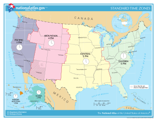
Time in the United States, by law, is divided into nine standard time zones covering the states, territories and other US possessions, with most of the United States observing daylight saving time (DST) for approximately the spring, summer, and fall months. The time zone boundaries and DST observance are regulated by the Department of Transportation, but no single map of those existed until the agency announced intentions to make one in September 2022. Official and highly precise timekeeping services (clocks) are provided by two federal agencies: the National Institute of Standards and Technology (NIST) ; and the United States Naval Observatory (USNO). The clocks run by these services are kept synchronized with each other as well as with those of other international timekeeping organizations.

.um was the Internet country code top-level domain for the United States Minor Outlying Islands. It was administered by the United States Minor Outlying Islands Registry. Until late 2006 USMIR was housed at the University of Southern California Information Sciences Institute (USC-ISI), which was the original administrator of .us prior to NeuStar absorbing that role.

<span class="mw-page-title-main">Atlantic Time Zone</span> Time zone (UTC−04:00)

The Atlantic Time Zone is a geographical region that keeps standard time—called Atlantic Standard Time (AST)—by subtracting four hours from Coordinated Universal Time (UTC), resulting in UTC−04:00. AST is observed in parts of North America and some Caribbean islands. During part of the year, some portions of the zone observe daylight saving time, referred to as Atlantic Daylight Time (ADT), by moving their clocks forward one hour to result in UTC−03:00. The clock time in this zone is based on the mean solar time of the 60th meridian west of the Greenwich Observatory.

<i>The National Map</i> USGS topographical information

The National Map is a collaborative effort of the United States Geological Survey (USGS) and other federal, state, and local agencies to improve and deliver topographic information for the United States. The purpose of the effort is to provide "...a seamless, continuously maintained set of public domain geographic base information that will serve as a foundation for integrating, sharing, and using other data easily and consistently".

<span class="mw-page-title-main">Central United States</span> Geographical region of the USA

The Central United States is sometimes conceived as between the Eastern and Western as part of a three-region model, roughly coincident with the U.S. Census' definition of the Midwestern United States plus the western and central portions of the U.S. Census' definition of the Southern United States. The Central States are typically considered to consist of North Dakota, South Dakota, Nebraska, Kansas, Oklahoma, Texas, Minnesota, Iowa, Missouri, Arkansas, Louisiana, Wisconsin, Illinois, Michigan, Indiana, Ohio, Kentucky, Tennessee, West Virginia, Mississippi and Alabama.

ESPN3 is an online streaming service owned by ESPN Inc., a joint venture between The Walt Disney Company and Hearst Communications, that provides live streams and replays of global sports events to sports fans in the United States.

<span class="mw-page-title-main">Outline of Guam</span> Overview of and topical guide to Guam

Guam The following outline is provided as an overview of and topical guide to Guam:

<span class="mw-page-title-main">Outline of American Samoa</span> Overview of and topical guide to American Samoa

The following outline is provided as an overview of and topical guide to American Samoa:

<span class="mw-page-title-main">Coordinated Universal Time</span> Primary time standard

Coordinated Universal Time or UTC is the primary time standard by which the world regulates clocks and time. It is within about one second of mean solar time at 0° longitude and is not adjusted for daylight saving time. It is effectively a successor to Greenwich Mean Time (GMT).

Time in Tunisia is given by a single time zone, officially denoted as Central European Time. Tunisia adopted WAT on 12 April 1911, and does not observe daylight saving time, though previously it has.

References

  1. United States Congress (November 2010). Congressional Record, V. 153, PT. 4, February 17, 2007 to March 12, 2007. Washington, D.C.: Government Printing Office. ISBN   9780160869761.