Malheur County is one of the 36 counties in the U.S. state of Oregon. As of the 2020 census, the population was 31,571. Its county seat is Vale, and its largest city is Ontario. The county was named after the Malheur River, which runs through the county. The word "malheur" is French for misfortune or tragedy. Malheur County is included in the Ontario, Oregon Micropolitan Statistical Area, which is also included in the Boise Combined Statistical Area. It is included in the eight-county definition of Eastern Oregon.

Harney County is one of the 36 counties in the U.S. state of Oregon. As of the 2020 census, the population was 7,495, making it the sixth-least populous county in Oregon. The county seat is Burns. Established in 1889, the county is named in honor of William S. Harney, a military officer of the period, who was involved in the Pig War and popular in the Pacific Northwest.

Ontario is the largest city in Malheur County, Oregon, United States. It lies along the Snake River at the Idaho border. The population was 11,645 at the 2020 census. The city is the largest community in the region of far eastern Oregon, also known as the Western Treasure Valley.

U.S. Route 95 (US 95) is a major north–south United States Highway in the western United States. It travels through the states of Arizona, California, Nevada, Oregon, and Idaho, staying inland from the Pacific Coast. US 95 begins in San Luis, Arizona, at the Mexican border, where Calle 1—a short spur—leads to Highway 2 in San Luis Río Colorado, Sonora. Its northern terminus is at the Canadian border in Eastport, Idaho, where the roadway continues north as British Columbia Highway 95.
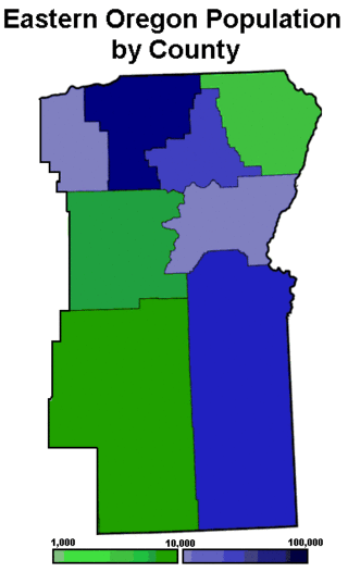
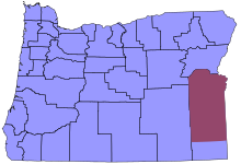
Eastern Oregon is a region of the U.S. state of Oregon. It is not an officially recognized geographic entity; thus, the boundaries of the region vary according to context. It is sometimes understood to include only the eight easternmost counties in the state; in other contexts, it includes the entire area east of the Cascade Range. Cities in the basic eight-county definition include Baker City, Burns, Hermiston, Pendleton, Boardman, John Day, La Grande, and Ontario. Umatilla County is home to the largest population base in Eastern Oregon, accounting for 42% of the region's residents. Hermiston, located in Umatilla County, is the largest city in the region, accounting for 10% of the population. Major industries include transportation/warehousing, timber, agriculture and tourism. The main transportation corridors are I-84, U.S. Route 395, U.S. Route 97, U.S. Route 26, U.S. Route 30, and U.S. Route 20.

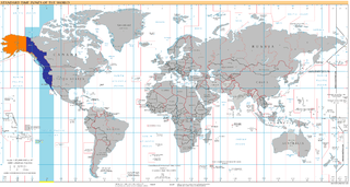
The Mountain Time Zone of North America keeps time by subtracting seven hours from Coordinated Universal Time (UTC) when standard time (UTC−07:00) is in effect, and by subtracting six hours during daylight saving time (UTC−06:00). The clock time in this zone is based on the mean solar time at the 105th meridian west of the Greenwich Observatory. In the United States, the exact specification for the location of time zones and the dividing lines between zones is set forth in the Code of Federal Regulations at 49 CFR 71.
The Pacific Time Zone (PT) is a time zone encompassing parts of western Canada, the western United States, and western Mexico. Places in this zone observe standard time by subtracting eight hours from Coordinated Universal Time (UTC−08:00). During daylight saving time, a time offset of UTC−07:00 is used.
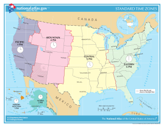
In the United States, time is divided into nine standard time zones covering the states, territories and other US possessions, with most of the country observing daylight saving time (DST) for approximately the spring, summer, and fall months. The time zone boundaries and DST observance are regulated by the Department of Transportation, but no single map of those existed until the agency announced intentions to make one in September 2022. Official and highly precise timekeeping services (clocks) are provided by two federal agencies: the National Institute of Standards and Technology (NIST) ; and the United States Naval Observatory (USNO). The clocks run by these services are kept synchronized with each other as well as with those of other international timekeeping organizations.

The Boise–Nampa, Idaho Metropolitan Statistical Area (MSA) is an area that encompasses Ada, Boise, Canyon, Gem, and Owyhee counties in southwestern Idaho, anchored by the cities of Boise and Nampa. It is the main component of the wider Boise–Mountain Home–Ontario, ID–OR Combined Statistical Area, which adds Elmore and Payette counties in Idaho and Malheur County, Oregon. It is the state's largest officially designated metropolitan area and includes Idaho's three largest cities: Boise, Nampa, and Meridian. Nearly 40 percent of Idaho's total population lives in the area.
Drewsey is an unincorporated community in Harney County, in the U.S. state of Oregon. Drewsey is along the main stem of the Malheur River, about 45 miles (72 km) east of Burns, off U.S. Route 20. It has the ZIP Code of 97904.
UTC−08:00 is an identifier for a time offset from UTC of −08:00. This time is used:
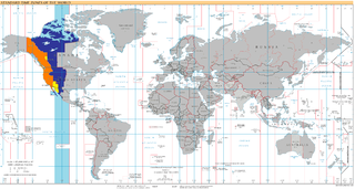
UTC−07:00 is an identifier for a time offset from UTC of −07:00. In North America, it is observed in the Mountain Time Zone during standard time, and in the Pacific Time Zone during the other eight months. Some locations use it year-round.
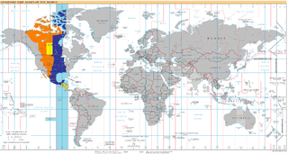
UTC−06:00 is an identifier for a time offset from UTC of −06:00. In North America, it is observed in the Central Time Zone during standard time, and in the Mountain Time Zone during the other eight months. Several Latin American countries and a few other places use it year-round.

Oregon Route 201 is a north–south state highway in eastern Oregon. It currently runs from the Idaho state line just south of Adrian to Interstate 84 south of Huntington. Between the state line and Succor Creek Road, it is known the Homedale Spur No. 490. Between Succor Creek Road and Nyssa, it is known as the Succor Creek Highway No. 450, including the Homedale Spur of the same highway. Between Nyssa and Cairo Junction, it is part of the Central Oregon Highway No. 7 as a concurrency with U.S. Route 20 and U.S. Route 26, and north of Cairo Junction, it is the Olds Ferry-Ontario Highway No. 455. At the Idaho state line, Oregon Route 201 becomes State Highway 19.
Qwest Corporation is a Regional Bell Operating Company owned by Lumen Technologies. It was formerly named U S WEST Communications, Inc. from 1991 to 2000, and also formerly named Mountain States Telephone and Telegraph Company, known as Mountain Bell from 1911 to 1991. It includes the former operations of Malheur Bell, Northwestern Bell and Pacific Northwest Bell as well.
Malheur Home Telephone Company, commonly known as Malheur Bell, was a rural telephone company operating in Oregon. It was a wholly owned subsidiary of Qwest Corporation, the Bell Operating Company of Qwest Communications International.
Juntura is an unincorporated community in Malheur County, Oregon, United States on U.S. Route 20. The word juntura is Spanish for "juncture", and the community was named for its proximity to the confluence of the Malheur River with the North Fork Malheur River. The name was probably selected by local settler B. L. Milligan, who arrived in the area in the 1880s and who later served as county school superintendent. Juntura post office was established in 1890 and is still operating. The community's development slowed after World War II, and on November 2, 1976, the town voted to disincorporate. Juntura is part of the Ontario micropolitan area.

William D. Hanley was a pioneer rancher in Harney County in southeastern Oregon. He owned several ranches between Burns, Oregon and Harney Lake. Together, his properties comprised one of the largest privately owned cattle operations in the United States. Hanley was also a progressive thinker and well known host. Among his personal friends were leading political figures, fellow cattle barons, industrialist, writers, and artists including Theodore Roosevelt, William Howard Taft, William Jennings Bryan, Peter French, James J. Hill, CES Wood, and Will Rogers. Hanley's progressive political views led him to run for Governor of Oregon and the United States Senate. A strong advocate of wildlife conservation, much of his ranch is now part of the Malheur National Wildlife Refuge.

The Double-O Ranch Historic District is located west of Harney Lake in Harney County in southeastern Oregon, United States. At one time, the Double-O Ranch covered over 17,000 acres (69 km2). The ranch was owned by Bill Hanley, a well-known cattle baron and Bull Moose progressive. In 1941, the United States Government purchased most of the Double O Ranch property and added it to the Malheur National Wildlife Refuge. The two remaining Double-O Ranch buildings are now listed on the National Register of Historic Places.

The U.S. state of Idaho is covered by two time zones, as described below. All locations observe daylight saving time.