Related Research Articles

Interstate 55 (I-55) is a major Interstate Highway in the central United States. As with most primary Interstates that end in a five, it is a major cross-country, north–south route, connecting the Gulf of Mexico to the Great Lakes. The highway travels from LaPlace, Louisiana, at I-10 to Chicago, Illinois, at U.S. Route 41, at McCormick Place. The major cities that I-55 connects to are New Orleans, Louisiana; Jackson, Mississippi; Memphis, Tennessee; St. Louis, Missouri; and Chicago, Illinois.

The North American Central Time Zone (CT) is a time zone in parts of Canada, the United States, Mexico, Central America and some Caribbean islands.
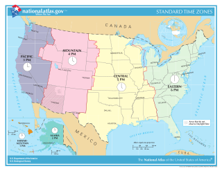
In the United States, time is divided into nine standard time zones covering the states, territories and other US possessions, with most of the country observing daylight saving time (DST) for approximately the spring, summer, and fall months. The time zone boundaries and DST observance are regulated by the Department of Transportation, but no single map of those existed until the agency announced intentions to make one in September 2022. Official and highly precise timekeeping services (clocks) are provided by two federal agencies: the National Institute of Standards and Technology (NIST) ; and the United States Naval Observatory (USNO). The clocks run by these services are kept synchronized with each other as well as with those of other international timekeeping organizations.

U.S. Route 54 is an east–west United States Highway that runs northeast–southwest for 1,197 miles (1,926 km) from El Paso, Texas, to Griggsville, Illinois. The Union Pacific Railroad's Tucumcari Line runs parallel to US 54 from El Paso to Pratt, Kansas, which comprises about two-thirds of the route. Truckers refer to this road as "The Bee Line."

U.S. Route 70 or U.S. Highway 70 is an east–west United States highway that runs for 2,381 miles (3,832 km) from eastern North Carolina to east-central Arizona. It is a major east–west highway of the Southeastern, Southern and Southwestern United States. Established as one of the original highways of 1926, it originally ran only to Holbrook, Arizona, then was extended in 1934 as a coast to coast route, with the current eastern terminus near the Atlantic Ocean in Atlantic, North Carolina, and the former western terminus near the Pacific Ocean in Los Angeles, California. The current western terminus was then truncated to US 60 / SR 77 in Globe, Arizona. Before the completion of the Interstate system, U.S. Highway 70 was sometimes referred to as the "Broadway of America", due to its status as one of the main east–west thoroughfares in the nation. It was also promoted as the "Treasure Trail" by the U.S. Highway 70 Association as of 1951.

The Central United States is sometimes conceived as between the Eastern and Western as part of a three-region model, roughly coincident with the U.S. Census's definition of the Midwestern United States plus the western and central portions of the U.S. Census's definition of the Southern United States. The Central States are typically considered to consist of North Dakota, South Dakota, Nebraska, Kansas, Oklahoma, Texas, Minnesota, Iowa, Missouri, Arkansas, Louisiana, Wisconsin, Illinois, Michigan, Indiana, Ohio, Kentucky, Tennessee, West Virginia, Mississippi and Alabama.

U.S. Route 127 (US 127) is a 758-mile-long (1,220 km) north–south U.S. Highway in the eastern half of the United States. The southern terminus of the route is at US 27 in Chattanooga, Tennessee. The northern terminus is at Interstate 75 (I-75) near Grayling, Michigan. Since 1987, it has been the core of the annual World's Longest Yard Sale, also known as the Highway 127 Corridor Sale, which now stretches 690 miles (1,110 km) from Addison, Michigan, to Gadsden, Alabama. The sale, held every August, was started to demonstrate that the older U.S. Highway System has something to offer that the Interstate Highway System does not. In Michigan, US 127 tripled in length in 2002, taking mileage from its parent, US 27.

U.S. Route 4 (US 4) is a part of the United States Numbered Highway System that runs from East Greenbush, New York, to Portsmouth, New Hampshire. In the U.S. state of New York, US 4 extends 79.67 miles (128.22 km) from an intersection with US 9 and US 20 in East Greenbush to the Vermont state line northeast of Whitehall. While the remainder of US 4 east of New York is an east–west route, US 4 in New York is signed north–south due to the alignment the route takes through the state. The portion of the route between Waterford and Whitehall is part of the Lakes to Locks Passage, an All-American Road.
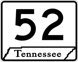
State Route 52 is an east–west state highway that crosses eight counties in northern and northeastern Tennessee. The 141.4-mile-long (227.6 km) route originates in Orlinda along SR 49 and ends in Elgin along U.S. Route 27.
Montalba is an unincorporated community in central Anderson County, Texas, United States. According to the Handbook of Texas, the community had a population of 809 in 2019. It is located within the Palestine, Texas micropolitan area.
U.S. Route 70 enters the state of Tennessee from Arkansas via the Memphis & Arkansas Bridge in Memphis, and runs west to east across 21 counties in all three Grand Divisions of Tennessee, with a total length of 478.48 miles (770.04 km), to end at the North Carolina state line in eastern Cocke County. Along the route, US 70 is accompanied with various U.S. and state highways, including those in three of the state's four major cities.

U.S. Route 62 (US 62) in Kentucky runs for a total of 391.207 miles (629.587 km) across 20 counties in western, north-central, and northeastern Kentucky. It enters the state by crossing the Ohio River near Wickliffe, then begins heading eastward at Bardwell, and traversing several cities and towns across the state up to Maysville, where it crosses the Ohio River a second time to enter the state of Ohio.

U.S. Route 79 in Tennessee enters the state from Arkansas via the Memphis & Arkansas Bridge in Memphis, and runs northeast through western and the northwestern portions of middle Tennessee, and leaving the state into Kentucky northeast of Clarksville. Along the route, US 79 is accompanied with several concurrencies, including hidden designations, throughout its alignment in Tennessee.

About 60% of Kentucky lies in the Eastern Time Zone, with the rest in the Central Time Zone, as follows:

State Route 27 is an east–west state highway in southeastern Tennessee. The 48.51-mile-long (78.07 km) route traverses portions of Marion and Hamilton counties in Tennessee, including the Chattanooga area. Both of this route's termini are at state lines. Its western end is at the Alabama state line near South Pittsburg, and its eastern end is at the Georgia state line on Chattanooga's south side.

State Route 88 is a west–east state highway in West Tennessee. The 44.78 miles (72.07 km) route traverses Lauderdale and Crockett Counties.

State Route 89 is a north-south state highway in the farmland of West Tennessee. The route is 51.24 miles (82.46 km) long.

State Route 140 is a west–east state highway located entirely in Henry County in northwest Tennessee.

State Route 134 is an east–west state highway in southeastern Tennessee. The 6.55 miles (10.54 km) state route traverses portions of southern Marion and southwestern Hamilton Counties. It travels along a path from Haletown to the Georgia state line.
References
- ↑ 65 counties, totaling 30,796 sq. mi. are in CT, while 30 counties, totaling 11,347 sq. mi. are in ET, based on individual Wikipedia county articles as of 2012-05-21.
- ↑ “Current time in Tennessee - Tennessee Time By County”. TimeTemperature.com. Retrieved 22 May 2013.
- ↑ Rand McNally (2016). "Tennessee" (Map). The Road Atlas (2016 Walmart ed.). 1 in≈30 mi. Chicago: Rand McNally. pp. 94–95. ISBN 0-528-00626-6.
- ↑ "Time Zone Database". www.iana.org.