Walworth County is a county in the U.S. state of South Dakota. As of the 2020 census, the population was 5,315. Its county seat is Selby. The county was created in 1873 and organized in 1883. It is named for Walworth County, Wisconsin.

Todd County is a county in the U.S. state of South Dakota. As of the 2020 census, the population was 9,319. Todd County does not have its own county seat. Instead, Winner in neighboring Tripp County serves as its administrative center. Its largest city is Mission. The county was created in 1909, although it remains unorganized. The county was named for John Blair Smith Todd, a delegate from Dakota Territory to the United States House of Representatives and a Civil War general.

Stanley County is a county in the U.S. state of South Dakota. As of the 2020 census, the population was 2,980. Its county seat is Fort Pierre. The county was created in 1873, and was organized in 1890. It is named for David S. Stanley, a commander at Fort Sully from 1866 to 1874, which was located nearby.

Jackson County is a county in the U.S. state of South Dakota. As of the 2020 census, the population was 2,806. Its county seat is Kadoka. The county was created in 1883, and was organized in 1915. Washabaugh County was merged into Jackson County in 1983.

Dewey County is a county in the U.S. state of South Dakota. As of the 2020 census, the population was 5,239. Its county seat is Timber Lake. The county was created in 1883 and organized in 1910. It was named for William P. Dewey, Territorial surveyor-general from 1873 to 1877.
Corson County is a county in the U.S. state of South Dakota. As of the 2020 census, the population was 3,902. Its county seat is McIntosh. The county was named for Dighton Corson, a native of Maine, who came to the Black Hills in 1876, and in 1877 began practicing law at Deadwood.
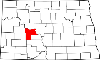
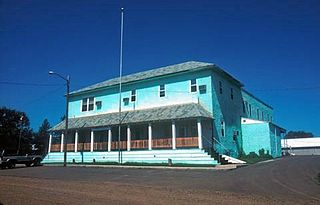
Mercer County is a county in the U.S. state of North Dakota. As of the 2020 census, the population was 8,350. Its county seat is Stanton.

Cherry County is a county located in the U.S. state of Nebraska. As of the 2020 United States Census, the population was 5,455. Its county seat is Valentine. The county was named for Lt. Samuel A. Cherry, an Army officer who was stationed at Fort Niobrara and who had been killed in South Dakota in 1881. Cherry County is in the Nebraska Sandhills. It is the largest county in the state at nearly 6,000 square miles (16,000 km2), larger than the state of Connecticut.

The North American Central Time Zone is a time zone in parts of Canada, the United States, Mexico, Central America, some Caribbean islands, and part of the Eastern Pacific Ocean.
The Mountain Time Zone of North America keeps time by subtracting seven hours from Coordinated Universal Time (UTC) when standard time (UTC−07:00) is in effect, and by subtracting six hours during daylight saving time (UTC−06:00). The clock time in this zone is based on the mean solar time at the 105th meridian west of the Greenwich Observatory. In the United States, the exact specification for the location of time zones and the dividing lines between zones is set forth in the Code of Federal Regulations at 49 CFR 71.
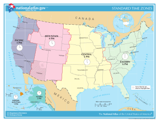
In the United States, time is divided into nine standard time zones covering the states, territories and other US possessions, with most of the country observing daylight saving time (DST) for approximately the spring, summer, and fall months. The time zone boundaries and DST observance are regulated by the Department of Transportation, but no single map of those existed until the agency announced intentions to make one in September 2022. Official and highly precise timekeeping services (clocks) are provided by two federal agencies: the National Institute of Standards and Technology (NIST) ; and the United States Naval Observatory (USNO). The clocks run by these services are kept synchronized with each other as well as with those of other international timekeeping organizations.

UTC−05:00 is an identifier for a time offset from UTC of −05:00. In North America, it is observed in the Eastern Time Zone during standard time, and in the Central Time Zone during the other eight months. The western Caribbean uses it year round.
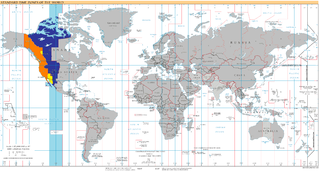
UTC−07:00 is an identifier for a time offset from UTC of −07:00. In North America, it is observed in the Mountain Time Zone during standard time, and in the Pacific Time Zone during the other eight months. Some locations use it year-round.
UTC−06:00 is an identifier for a time offset from UTC of −06:00. In North America, it is observed in the Central Time Zone during standard time, and in the Mountain Time Zone during the other eight months. Several Latin American countries and a few other places use it year-round.
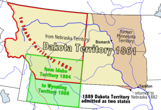
Dakota Territory's at-large congressional district is an obsolete congressional district that encompassed the entire Dakota Territory prior to admission to the Union. The district elected a delegate to the United States Congress.

The Lake Traverse Indian Reservation is the homeland of the federally recognized Sisseton Wahpeton Oyate, a branch of the Santee Dakota group of Native Americans. Most of the reservation covers parts of five counties in northeastern South Dakota, while smaller parts are in two counties in southeastern North Dakota, United States. The Reservation was created by treaty on April 22 1867 and called the Flatiron Reservation in reference to its triangular shape. It was created for the "friendly Dakota" from the Minnesota hostilities of 1862-1866. Signatories of the treaty were Gabriel Renville, John Otherday plus twenty-one other Sisseton and Wahpeton leaders. Gabriel Renville was the first Chief of the Reservation.

The South Dakota State Jackrabbits football team represents South Dakota State University in college football. The program competes at the NCAA Division I Football Championship Subdivision (FCS) level as member of the Missouri Valley Football Conference (MVFC). The Jackrabbits play their home games at Dana J. Dykhouse Stadium on South Dakota State's campus in Brookings, South Dakota. South Dakota State is considered to be among the few perennial powers in the FCS. South Dakota State is also one of only 13 FCS schools to host ESPN's College GameDay. For the 2019 GameDay matchup, the No. 3 Jackrabbits hosted the No. 1 North Dakota State Bison, where they would lose in a close battle 23–16 after losing their starting QB to a season ending knee injury. The Jackrabbits currently have a 12-year streak of qualifying for the FCS playoffs, the second-longest in the country at the FCS level. They also have cemented their status as an FCS blueblood with their first National Championship win in school history on January 8th, 2023.
North Dakota Highway 31 (ND 31) is a north–south state highway in the U.S. state of North Dakota. The southern segments southern terminus is a continuation as South Dakota Highway 65 (SD 65) at the South Dakota border, and the northern terminus is at ND 21 west of Flasher. The northern segments southern terminus is at Interstate 94 (I-94) north of New Salem and the northern terminus is a continuation as County Route 37 (CR 37) at the end of state maintenance in Stanton.