Phenix City, Alabama

Last updated

Phenix City, Alabama
Phenix-city+1.jpg
Aerial view of Phenix City (c.2009)
Flag of Phenix City, Alabama.png
Seal of Phenix City, Alabama.png
Lee County and Russell County Alabama Incorporated and Unincorporated areas Phenix City Highlighted 0159472.svg
Location of Phenix City in Lee and Russell counties, Alabama.
Usa edcp location map.svg
Red pog.svg
Phenix City, Alabama
Location in the United States
Coordinates: 32°28′15″N85°00′10″W / 32.47083°N 85.00278°W / 32.47083; -85.00278
CountryUnited States
State Alabama
Counties Russell, Lee
Government
  Mayor Eddie N. Lowe (D)
Area
[1]
  Total28.25 sq mi (73.17 km2)
  Land28.14 sq mi (72.87 km2)
  Water0.11 sq mi (0.29 km2)
Elevation
243 ft (74 m)
Population
 (2020)
  Total38,817
  Density1,379.58/sq mi (532.65/km2)
Time zones UTC-6 (CST (de jure))
  Summer (DST) UTC-5 (CDT (de jure))
UTC-5 (EST (de facto))
  Summer (DST) UTC-4 (EDT (de facto))
ZIP codes
36867-36870
Area code 334
FIPS code 01-59472
GNIS feature ID0155193
Website phenixcityal.us

Phenix City is a city in Lee and Russell counties in the U.S. state of Alabama, and the county seat of Russell County. [2] As of the 2020 Census, the population of the city was 38,817.

Contents

Phenix City lies immediately west across the Chattahoochee River from Columbus, Georgia and observes Eastern Time on a de facto basis (in contrast to the rest of Alabama, which observes Central Time) due to Phenix City's strong economic ties to Columbus. Most of Phenix City is included in the Columbus Metropolitan Statistical Area, and the remainder is in Lee County and therefore included in the Auburn, Alabama Metropolitan Statistical Area. The entire city is part of the Columbus-Auburn-Opelika Combined Statistical Area.

In 2007, BusinessWeek named Phenix City the nation's No. 1 Best Affordable Suburb to raise a family. [3] It is home to Chattahoochee Valley Community College, a public, two-year college with an acceptance rate of 100%. [4] Troy University has a satellite campus in Phenix City.

As of 2023, the mayor is Eddie N. Lowe, the city's first black mayor elected by the public. The city manager, who holds the task of organizational matters, is Wallace Hunter.

Geography

Phenix City is located at 32°28′22″N85°1′12″W / 32.47278°N 85.02000°W / 32.47278; -85.02000 (32.472822, −85.020121). [5] It is the easternmost settlement in the state of Alabama as well as the Central Time Zone, but it and some other nearby areas unofficially observe Eastern Time, as these areas are part of the metropolitan area of the considerably larger city of Columbus, Georgia, which is in the Eastern Time Zone and adjacent to the city across the Chattahoochee River to the east. [6]

Several major highways run through Phenix City, namely U.S. Routes 80, 280, and 431. U.S. Route 80 runs through the northern and western parts of the city, leading west 44 mi (71 km) to Tuskegee and northeast to Columbus, Georgia. U.S. 280 runs through the western part of the city from northwest to southeast, leading northwest 27 mi (43 km) to Opelika and southeast into Columbus. U.S. 431 runs north to south to the west of the city, concurrent with US 280, which it follows to Opelika, and leads south 47 mi (76 km) to Eufaula.

According to the U.S. Census Bureau, the city has a total area of 24.8 square miles (64 km2), of which 24.6 square miles (64 km2) is land and 0.2 square miles (0.52 km2) (0.61%) is water.

Climate

The climate in this area is characterized by relatively high temperatures and evenly distributed precipitation throughout the year. According to the Köppen Climate Classification system, Phenix City has a humid subtropical climate, abbreviated "Cfa" on climate maps. [7]

Climate data for Phenix City, Alabama
MonthJanFebMarAprMayJunJulAugSepOctNovDecYear
Mean daily maximum °F (°C)57
(14)
61
(16)
69
(21)
77
(25)
84
(29)
90
(32)
92
(33)
91
(33)
86
(30)
77
(25)
68
(20)
59
(15)
76
(24)
Mean daily minimum °F (°C)36
(2)
39
(4)
45
(7)
52
(11)
61
(16)
69
(21)
72
(22)
71
(22)
66
(19)
54
(12)
44
(7)
38
(3)
54
(12)
Average precipitation inches (mm)4.1
(100)
4.5
(110)
5.7
(140)
4.1
(100)
3.8
(97)
3.9
(99)
5.3
(130)
4
(100)
3.3
(84)
2.3
(58)
3.6
(91)
4.5
(110)
49.1
(1,250)
Source: Weatherbase [8]

History

Russell County Courthouse in Phenix City New Russell County Courthouse.JPG
Russell County Courthouse in Phenix City

What some claim was the last battle of the American Civil War, the Battle of Columbus, took place here on April 16, 1865, in Phenix City, then known as Girard. [9] Union General James Wilson was met with Confederate opposition as he crossed the Chattahoochee River in an attempt to destroy the military industry of Columbus, Georgia.

Today's Phenix City initially began as two towns bordering each other on the North and South. On the south side was Girard, in Russell County, and the town of Brownville, on the north side, which was entirely within Lee County. Because a community in Tuscaloosa County already claimed the name of Brownville, the post office insisted on the name of "Lively". To compound the confusion, the nearby railroad depot was called Knight's Station. Because residents preferred Brownville, on the 1880 U.S. Census, it was listed as both Brownville and Lively. It was formally incorporated by the legislature on February 23, 1883. [10]

Within the decade, the name would be changed to Phenix (or Phenix City), although some misspellings had it as "Phoenix". It was not clear if it was named for Phenix Mills in nearby Columbus, Georgia or for the fabled bird. It appeared as Phenix City on the 1890 U.S. census and was incorporated as such on February 19, 1897, by the state legislature. The city's official website displays the mythical phoenix, while the city's seal also depicts a phoenix burning up in its nest. The 'Our Community/History' page confirms the uncertainty behind the name: "Although no definitive source reveals whythis name was chosen."

On August 9, 1923, Russell County's neighboring Girard (which made up most of current downtown Phenix City) and Lee County's Phenix City formally merged, keeping the name of Phenix City. Because the consolidated city still remained divided into two counties, in 1932, the Lee County portion was moved entirely into Russell County (also cited for the redraw was to account for population shifts involved in the Auburn University opening and expansion). Lee County received the rural segment at Marvyn as compensation, which was formerly in Russell County's northwest corner.

In 1926, the Russell County portion of Phenix City was designated the second county seat (the seat from 1868 had been at rural Seale). In 1934/35, Phenix City then became the sole county seat.

Phenix City was notorious during the 1940s and 1950s for being a haven for organized crime, prostitution, and gambling. Many of its customers came from the United States Army training center at Fort Benning, Georgia. The leaders of the crime syndicate in Phenix City were Jimmie Matthews and Hoyt Shepherd. Albert Patterson, from Phenix City, was elected to become attorney general of Alabama on a platform of reforming the city, but was shot and killed in 1954 outside his office on 5th Ave, north of 14th Street. As a result, the city had a negative reputation, and many people still associate this legacy with Phenix City. The Tragedy and the Triumph of Phenix City, Alabama by Margaret Ann Barnes chronicles these events, which led the small town to be known as "Sin City, USA". The bordertown was the subject of an acclaimed film, The Phenix City Story , made in 1955.

In 1955, it won the All-America City Award from the National Municipal League.

Despite the city having been entirely annexed into Russell County in 1932, the growth of the city has spread northward back into Lee County, where it first appeared on 1980 U.S. Census records. As of 2010, nearly 4,200 residents (out of almost 33,000) reside in the Lee County portion. [11]

Religion

Phenix City is home to many Christian churches. The denominations include: [12]

Demographics

Historical population
CensusPop.Note
1880 2,224
1890 3,70066.4%
1900 4,16312.5%
1910 4,5559.4%
1920 5,43219.3%
1930 13,862155.2%
1940 15,35110.7%
1950 23,30551.8%
1960 27,63018.6%
1970 25,281−8.5%
1980 26,9286.5%
1990 25,312−6.0%
2000 28,26511.7%
2010 32,82216.1%
2020 38,81718.3%
U.S. Decennial Census [14]
2018 Estimate [15]
Phenix City Municipal building Phenix City Alabama Municipal Building.JPG
Phenix City Municipal building

2000 census

As of the census of 2000, there were 28,265 people, 11,517 households, and 7,566 families residing in the city. The population density was 1,149.1 inhabitants per square mile (443.7/km2). There were 13,250 housing units at an average density of 538.7 per square mile (208.0/km2). The racial makeup of the city was 52.94% White, 44.97% Black or African American, 0.23% Native American, 0.53% Asian, 0.02% Pacific Islander, 0.56% from other races, and 0.76% from two or more races. 1.49% of the population were Hispanic or Latino of any race.

There were 11,517 households, out of which 31.7% had children under the age of 18 living with them, 39.4% were married couples living together, 22.1% had a female householder with no husband present, and 34.3% were non-families. 30.4% of all households were made up of individuals, and 11.5% had someone living alone who was 65 years of age or older. The average household size was 2.40 and the average family size was 2.99.

In the city, the population was spread out, with 26.3% under the age of 18, 9.6% from 18 to 24, 28.7% from 25 to 44, 21.2% from 45 to 64, and 14.2% who were 65 years of age or older. The median age was 35 years. For every 100 females, there were 86.2 males. For every 100 females age 18 and over, there were 80.4 males.

The median income for a household in the city was $26,720, and the median income for a family was $33,740. Males had a median income of $28,906 versus $21,348 for females. The per capita income for the city was $14,619. About 18.8% of families and 21.3% of the population were below the poverty line, including 29.5% of those under age 18 and 20.6% of those age 65 or over.

2010 census

As of the census of 2010, there were 32,822 people, 13,243 households, and 8,623 families residing in the city. The population density was 1,334.2 inhabitants per square mile (515.1/km2). There were 15,198 housing units at an average density of 617.8 per square mile (238.5/km2). The racial makeup of the city was 48.7% White, 46.6% Black or African American, 0.3% Native American, 0.7% Asian, 0.2% Pacific Islander, 1.4% from other races, and 2.2% from two or more races. 4.0% of the population were Hispanic or Latino of any race.

There were 13,243 households, out of which 31.8% had children under the age of 18 living with them, 36.4% were married couples living together, 23.9% had a female householder with no husband present, and 34.9% were non-families. 30.1% of all households were made up of individuals, and 9.5% had someone living alone who was 65 years of age or older. The average household size was 2.44 and the average family size was 3.03.

In the city, the population was spread out, with 26.9% under the age of 18, 10.4% from 18 to 24, 27.9% from 25 to 44, 23.0% from 45 to 64, and 11.8% who were 65 years of age or older. The median age was 33.1 years. For every 100 females, there were 87.7 males. For every 100 females age 18 and over, there were 86.0 males.

The median income for a household in the city was $33,120, and the median income for a family was $39,417. Males had a median income of $36,827 versus $27,001 for females. The per capita income for the city was $18,883. About 20.3% of families and 23.9% of the population were below the poverty line, including 39.7% of those under age 18 and 13.1% of those age 65 or over.

2020 census

Phenix City racial composition [16]
RaceNum.Perc.
White (non-Hispanic)15,52540.0%
Black or African American (non-Hispanic)18,79548.42%
Native American 1000.26%
Asian 3660.94%
Pacific Islander 610.16%
Other/Mixed 1,6584.27%
Hispanic or Latino 2,3115.95%

As of the 2020 United States census, there were 38,816 people, 14,716 households, and 9,170 families residing in the city.

Time zone

Unlike the rest of Alabama which lies in the Central Time Zone, Phenix City's proximity to the larger city of neighboring Columbus, Georgia, located in the Eastern Time Zone, and its strong economic links leads Phenix City (including its municipal government) and localities within a 10–15 mi (16–24 km) radius (such as Smiths Station) to observe Eastern Time on a de facto basis. [17] [18] [19] [20]

Media

There are three radio stations licensed in Phenix City: WHTY (1460 AM), WURY-LP (97.1 FM), & WGSY (100.1 FM).

Sister cities

Notable people

Related Research Articles

<span class="mw-page-title-main">Clay County, Georgia</span> County in Georgia, United States

Clay County is a county located in the southwestern part of the U.S. state of Georgia. As of the 2020 census, the population was 2,848, making it the fourth-least populous county in Georgia. The county seat is Fort Gaines.

<span class="mw-page-title-main">Lee County, Alabama</span> County in Alabama, United States

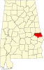
Lee County is a county located in east central Alabama. As of the 2020 census the population was 174,241. The county seat is Opelika, and the largest city is Auburn. The county was established in 1866 and is named for General Robert E. Lee (1807–1870), who served as General in Chief of the Armies of the Confederate States in 1865. Lee County comprises the Auburn-Opelika, AL Metropolitan Statistical Area, which is included in the Columbus-Auburn-Opelika, GA-AL Combined Statistical Area.

<span class="mw-page-title-main">Russell County, Alabama</span> County in Alabama, United States

Russell County is a county in the southeastern part of the U.S. state of Alabama. As of the 2020 census, the population was 59,183. Its county seat is Phenix City. Its name is in honor of Colonel Gilbert C. Russell, who fought in the wars against the Creek Indians.

<span class="mw-page-title-main">Muscogee County, Georgia</span> County in Georgia, United States

Muscogee County is a county located on the central western border of the U.S. state of Georgia named after the Muscogee that originally inhabited the land with its western border with the state of Alabama that is formed by the Chattahoochee River. As of the 2020 census, the population was 206,922. Its county seat and only city is Columbus, with which it has been a consolidated city-county since the beginning of 1971.

<span class="mw-page-title-main">Habersham County, Georgia</span> County in Georgia, United States

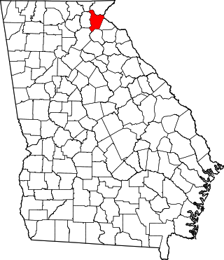
Habersham County is a county located in the northeastern part of the U.S. state of Georgia. As of the 2020 census, the population was 46,031. The county seat is Clarkesville. The county was created on December 15, 1818, and named for Colonel Joseph Habersham of the Continental Army in the Revolutionary War.

<span class="mw-page-title-main">Chattahoochee County, Georgia</span> County in Georgia, United States

Chattahoochee County, also known as Cusseta-Chattahoochee County, is a county located on the western border in central Georgia. As of the 2020 census, the population was 9,565. The county seat is Cusseta, with which the county shares a consolidated city-county government. The city of Cusseta remains a geographically distinct municipality within Chattahoochee County. The county was created on February 13, 1854.

<span class="mw-page-title-main">LaFayette, Alabama</span> City in Alabama, United States

LaFayette is the county seat of Chambers County, Alabama, United States, 47 miles (76 km) northwest of Columbus, Georgia. As of the 2010 census, the population of the city was 3,003.

<span class="mw-page-title-main">Lanett, Alabama</span> City in Alabama, United States

Lanett is a city in Chambers County, Alabama, United States. At the 2010 census the population was 6,468, down from 7,897 in 2000. Lanett, originally called Bluffton, is located in eastern Alabama, on the Chattahoochee River, southwest of Atlanta. The city's name is derived from Lafayette Lanier and Theodore Bennett, founders of the West Point Manufacturing Company.

<span class="mw-page-title-main">Valley, Alabama</span> City in Alabama, United States

Valley is a city in Chambers County, Alabama, United States. Valley was incorporated in 1980 combining the four textile mill villages of Fairfax, Langdale, River View, and Shawmut. As of the 2010 census it had a population of 9,524. The city lies on the western bank of the Chattahoochee River, the state border between Alabama and Georgia. Valley is a pilot city for the Alabama Communities of Excellence program, a non-profit that partners with governments, businesses, and universities to prepare participating communities for a more vibrant future. It is included in the LaGrange, Georgia Micropolitan Statistical Area, which is included in the Greater Atlanta Combined Statistical Area.

<span class="mw-page-title-main">Greensboro, Alabama</span> City in Alabama, United States

Greensboro is a city in Hale County, Alabama, United States. At the 2010 census the population was 2,497, down from 2,731 at the 2000 census. The city is the county seat of Hale County, Alabama, which was not organized until 1867. It is part of the Tuscaloosa, Alabama Metropolitan Statistical Area.

<span class="mw-page-title-main">Columbia, Alabama</span> Town in Alabama, United States

Columbia is a town in Houston County, Alabama, United States. It is part of the Dothan, Alabama Metropolitan Statistical Area. At the 2010 census the population was 740, down from 804 in 2000.

<span class="mw-page-title-main">Smiths Station, Alabama</span> City in Alabama, United States

Smiths Station is a city in Lee County, Alabama, United States. It is part of the Columbus, Georgia metropolitan area. At the time of the 2000 census, it was still a census-designated place (CDP), and its population was 6,756. The area that incorporated as Smiths Station in 2001 was much smaller than the CDP, and contained a population of 4,926 by the 2010 census. Smiths Station, known to locals as "Smiths", is a bedroom community of Columbus, Georgia, and Phenix City, Alabama. Smiths Station High School has an enrollment of over 1,800 students and is the 11th-largest high school in the state.

<span class="mw-page-title-main">Hurtsboro, Alabama</span> Town in Alabama, United States

Hurtsboro is a town in Russell County, Alabama, United States. At the 2010 census the population was 553, down from 592 in 2000. It was founded in 1857 as Hurtsville and named for Joel Hurt, Sr.. A railroad spur from Columbus, Georgia was completed the next year. It was incorporated in 1872 and in 1883 the town name was changed to Hurtsboro.

<span class="mw-page-title-main">Whitesburg, Georgia</span> Town in Georgia, United States

Whitesburg is a town in Carroll County, Georgia, United States. The population was 588 at the 2010 census.

<span class="mw-page-title-main">Fort Benning South, Georgia</span> CDP in Georgia, United States

Fort Benning South is a former census-designated place (CDP) in Chattahoochee County, Georgia, United States. It is part of the Columbus, Georgia-Alabama metropolitan statistical area. The population was 11,737 at last official census (2000). The area is now part of consolidated Cusseta–Chattahoochee County.

<span class="mw-page-title-main">Summerville, Georgia</span> City in Georgia, United States

Summerville is a city and the county seat of Chattooga County, Georgia, United States. The population was 4,534 at the 2010 census.

<span class="mw-page-title-main">Fort Gaines, Georgia</span> City in Georgia, United States

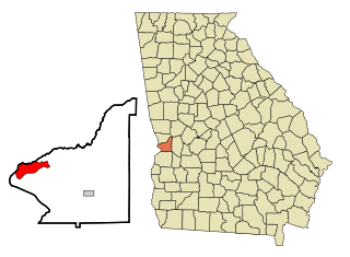
Fort Gaines is a city in and the county seat of Clay County, Georgia, United States. It has a population of 1,107 as of the 2010 census.

<span class="mw-page-title-main">Columbus, Georgia</span> Consolidated city-county in the United States

Columbus is a consolidated city-county located on the west-central border of the U.S. state of Georgia. Columbus lies on the Chattahoochee River directly across from Phenix City, Alabama. It is the county seat of Muscogee County, with which it officially merged in 1970; the original merger excluded Bibb City, which joined in 2000 after dissolving its own city charter.

<span class="mw-page-title-main">Columbus metropolitan area, Georgia</span> Metropolitan statistical area in Georgia, United States

The Columbus metropolitan area, officially the Columbus metropolitan statistical area, and colloquially known as the Chattahoochee Valley, is a metropolitan statistical area consisting of six counties in the U.S. state of Georgia and one county in Alabama, anchored by the city of Columbus.

<span class="mw-page-title-main">Columbus–Auburn–Opelika combined statistical area</span> CSA in the United States

The Columbus–Auburn–Opelika, GA–AL Combined Statistical Area is a trading and marketing area made up of six counties in Georgia and two in Alabama. The statistical area includes two metropolitan areas: the Columbus metropolitan area and the Auburn–Opelika metropolitan area. As of 2021, the CSA had a population of 503,709.

References

  1. "2020 U.S. Gazetteer Files". United States Census Bureau. Retrieved October 29, 2021.
  2. "Find a County". National Association of Counties. Retrieved June 7, 2011.
  3. "Best Affordable Suburbs 2007". BusinessWeek . December 13, 2007. Archived from the original on December 14, 2007. Retrieved February 11, 2008.
  4. "Colleges in Phenix City, Alabama and Colleges near Phenix City".
  5. "US Gazetteer files: 2010, 2000, and 1990". United States Census Bureau. February 12, 2011. Retrieved April 23, 2011.
  6. "EXTREME SETTLEMENTS: A COMPREHENSIVE LIST". Weekend Roady. May 2, 2013. Retrieved August 20, 2014.
  7. Climate Summary for Phenix City, Alabama
  8. "Phenix City, Alabama". Weatherbase. 2013. Retrieved September 28, 2013.
  9. The Last True Battle
  10. "Phenix City".
  11. 1880–2010 U.S. Censuses research on Brownville and Phenix City, Alabama
  12. Churches in Phenix City, Alabama
  13. Adventist Church Connect – Phenix City
  14. "U.S. Decennial Census". Census.gov. Retrieved June 6, 2013.
  15. "Population Estimates". United States Census Bureau . Retrieved June 8, 2018.
  16. "Explore Census Data". data.census.gov. Retrieved December 13, 2021.
  17. "northamerica". tzdata. IANA. 2012c. Retrieved June 8, 2012.
  18. "A time zone can be a state of mind". The Huntsville Times. August 26, 2005. p. 2A.
  19. Grubman, Cathy (October 27, 1994). "What Time Is It Anyway? It Depends on Your Location & the Season". The Washington Post.
  20. "Exceptions, Oddities, and Notes". OnTimeZone.com. Retrieved June 8, 2012.