
Jackson County is the northeasternmost county in the U.S. state of Alabama. As of the 2010 census, the population was 53,227. The county seat is Scottsboro. The county was named for Andrew Jackson, general in the United States Army and afterward President of the United States of America. Jackson County is a prohibition or dry county, but three cities within the county are "wet", allowing alcohol sales. Jackson County comprises the Scottsboro, AL Micropolitan Statistical Area. This is included in the Chattanooga-Cleveland-Dalton, TN-GA-AL Combined Statistical Area. It is the site of Russell Cave National Monument, an archeological site with evidence of 8,000 years of human occupation in the Southeast.

Lee County is a county located in east central Alabama. As of the 2010 census the population was 140,247. The county seat is Opelika, and the largest city is Auburn. The county is named for General Robert E. Lee (1807–1870), who served as General in Chief of the Armies of the Confederate States in 1865. Lee County comprises the Auburn-Opelika, AL Metropolitan Statistical Area, which is included in the Columbus-Auburn-Opelika, GA-AL Combined Statistical Area.

Russell County is a county in the southeastern part of the U.S. state of Alabama. As of the 2010 census, the population was 52,947. Its county seat is Phenix City. Its name is in honor of Colonel Gilbert C. Russell, who fought in the wars against the Creek Indians.

Phenix City is a city in Lee and Russell counties in the U.S. state of Alabama, and the county seat of Russell County. As of the 2010 census, the population of the city was 32,822.

UTC−05:00 is an identifier for a time offset from UTC of −05:00. In North America, it is observed in the Eastern Time Zone during standard time, and in the Central Time Zone during the other eight months. The western Caribbean uses it year round.

The United States District Court for the Middle District of Alabama is a federal court in the Eleventh Circuit.

UTC−04:00 is an identifier for a time offset from UTC of −04:00. It is observed in the Eastern Time Zone during the warm months of daylight saving time, as Eastern Daylight Time. The Atlantic Time Zone observes it during standard time . It is observed all year in the Eastern Caribbean.
Marvyn, also spelled Marvin, is an unincorporated community located in southern Lee County, Alabama, United States. It sits at the crossroads of Alabama Highway 51 and U.S. Highway 80, and in the Lee County "panhandle" between Russell County and Macon County. It is part of the Columbus, Georgia-Alabama Metropolitan Area.

This is a list of the National Register of Historic Places listings in Russell County, Alabama.
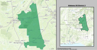
Alabama's 3rd congressional district is a United States congressional district in Alabama that elects a representative to the United States House of Representatives. It is based in east central Alabama and encompasses portions of Montgomery and the entirety of Calhoun, Chambers, Cherokee, Clay, Cleburne, Lee, Macon, Randolph, Russell, St. Clair, Talladega, and Tallapoosa counties.

William Russell Smith was a prominent Alabama politician who served in both the United States Congress and the Confederate Congress.

Glenville is an unincorporated community in Russell County, Alabama, United States which used to be in Barbour County. During the Civil War, Company "H" of the 15th Regiment Alabama Infantry was raised from Barbour and Dale counties and called the "Glenville Guards". The Glennville Historic District, containing the antebellum core of the community, is a historic district listed on the National Register of Historic Places in 1979.

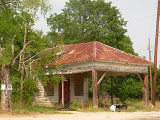
Seale is an unincorporated community in Russell County, Alabama, United States. It was the county seat from 1868 until 1935, and is currently home to Russell County High School and middle school. The former Russell County courthouse, built in 1868, is located in the town.

The following outline is provided as an overview of and topical guide to the U.S. state of Alabama:
Wende is a hamlet in the town of Alden in Erie County, New York, United States.

Hatchechubbee is an unincorporated community in Russell County, Alabama, United States. Hatchechubbee is located at the junction of Alabama State Route 26 and County Route 65, 6.5 miles (10.5 km) west-southwest of Seale. Hatchechubbee has a post office with ZIP code 36858, which opened on August 17, 1855.

Crawford is an unincorporated community in Russell County, Alabama, United States. Crawford is located at the junction of U.S. Route 80 and Alabama State Route 169, 6.5 miles (10.5 km) west of Ladonia. It was the second county seat of Russell County from 1839-1868 before it removed to Seale.
Mount Hope is an unincorporated community in Lawrence County, Alabama, United States. Its ZIP code is 35651.

The 1972 United States presidential election in Alabama was held on November 7, 1972. Incumbent President Richard Nixon won Alabama, winning 72.43% of the vote to George McGovern's 25.54%. This is also the best showing in the state by a Republican presidential candidate. As of the 2016 presidential election, this is the last election in which Dallas County, Hale County, Russell County, and Perry County voted for the Republican candidate.


