Bryant, Arkansas

Last updated

Bryant, Arkansas
Motto: 
Geographical center of ARKANSAS"
Saline County Arkansas Incorporated and Unincorporated areas Bryant Highlighted 0509460.svg
Location of Bryant in Saline County, Arkansas.
Coordinates: 34°37′49″N92°30′25″W / 34.63028°N 92.50694°W / 34.63028; -92.50694
Country United States
State Arkansas
County Saline
Area
[1]
  Total20.58 sq mi (53.31 km2)
  Land20.49 sq mi (53.08 km2)
  Water0.09 sq mi (0.23 km2)
Elevation
[2]
377 ft (115 m)
Population
 (2020)
  Total20,663
  Density1,008.25/sq mi (389.28/km2)
Time zone UTC-6 (Central (CST))
  Summer (DST) UTC-5 (CDT)
ZIP codes
72022, 72089
Area code 501
FIPS code 05-09460
GNIS feature ID2403945 [2]
Website cityofbryant.com

Bryant is a city in Saline County, Arkansas, United States and a suburb of Little Rock. According to the 2010 Census, the population of the city was 16,688. [3] It is part of the Central Arkansas region.

Contents

History

European settlers established themselves along Hurricane Creek in the early 19th century. A skirmish in the area occurred during the American Civil War. [4] Rail service in the 1870s brought development. [5] The town was hard hit by economic struggles in the early 20th century and through the Great Depression. World War II era saw development as demand for the area's bauxite grew. [4]

Geography

According to the United States Census Bureau, the city has a total area of 9.1 square miles (24 km2), of which 9.1 square miles (24 km2) is land and 0.04 square miles (0.10 km2) (0.33%) is water.

Demographics

Historical population
CensusPop.Note
1900 113
1910 91−19.5%
1920 13245.1%
1930 16222.7%
1940 1736.8%
1950 387123.7%
1960 73790.4%
1970 1,19962.7%
1980 2,682123.7%
1990 5,26996.5%
2000 9,76485.3%
2010 16,68870.9%
2020 20,66323.8%
U.S. Decennial Census [6]

2020 census

Bryant racial composition [7]
RaceNumberPercentage
White (non-Hispanic)14,51270.23%
Black or African American (non-Hispanic)3,17715.38%
Native American 800.39%
Asian 4732.29%
Pacific Islander 80.04%
Other/Mixed 1,0375.02%
Hispanic or Latino 1,3766.66%

As of the 2020 United States census, there were 20,663 people, 8,203 households, and 5,260 families residing in the city.

2000 census

As of the census [8] of 2000, there were 9,764 people, 3,601 households, and 2,823 families residing in the city. The population density was 1,076.4 inhabitants per square mile (415.6/km2). There were 3,762 housing units at an average density of 414.7 per square mile (160.1/km2). The racial makeup of the city was 95.2% White, 1.5% Black or African American, 0.34% Native American, 1.05% Asian, 0.37% from other races, and 0.84% from two or more races. 1.05% of the population were Hispanic or Latino of any race.

There were 3,601 households, out of which 42.6% had children under the age of 18 living with them, 63.9% were married couples living together, 11.1% had a female householder with no husband present, and 21.6% were non-families. 19.1% of all households were made up of individuals, and 7.0% had someone living alone who was 65 years of age or older. The average household size was 2.65 and the average family size was 3.03.

In the city, the population was spread out, with 27.9% under the age of 18, 7.1% from 18 to 24, 32.7% from 25 to 44, 21.8% from 45 to 64, and 10.4% who were 65 years of age or older. The median age was 35 years. For every 100 females, there were 89.8 males. For every 100 females age 18 and over, there were 86.5 males.

The median income for a household in the city was $48,870, and the median income for a family was $56,038. Males had a median income of $39,380 versus $26,261 for females. The per capita income for the city was $20,730. About 3.5% of families and 4.8% of the population were below the poverty line, including 6.1% of those under age 18 and 8.0% of those age 65 or over.

Water supply

Bryant purchases treated surface water from Lake Maumelle and Lake Winona from Central Arkansas Water.

Government and infrastructure

The Arkansas Department of Human Services Arkansas Juvenile Assessment & Treatment Center (AJATC) is located in Bryant. [9] [10]

The U.S. Postal Service operates the Bryant Post Office. [11]

Education

Public education for elementary and secondary school students is provided by the Bryant School District, with students graduating from Bryant High School. [12]

Notable people

Related Research Articles

<span class="mw-page-title-main">Saline County, Arkansas</span> County in Arkansas, United States

Saline County is located in the U.S. state of Arkansas. As of the 2020 census, the population was 123,416. Its county seat and largest city is Benton. Saline County was formed on November 2, 1835, and named for the salt water (brine) springs in the area, despite a differing pronunciation from saline. Until November 2014, it was an alcohol prohibition or dry county.

<span class="mw-page-title-main">Cleveland County, Arkansas</span> County in Arkansas, United States

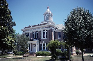
Cleveland County is a county located in the U.S. state of Arkansas. Its population was 7,550 at the 2020 U.S. census. The county seat and largest city is Rison.

<span class="mw-page-title-main">Decatur, Arkansas</span> City in Arkansas, United States

Decatur is a city, in Benton County, Arkansas, United States. The population was 1,773 at the 2020 census. It is part of the Northwest Arkansas region. This town is named after Commodore Stephen Decatur, Jr.

<span class="mw-page-title-main">Tull, Arkansas</span> Town in Arkansas, United States

Tull is a town in Grant County, Arkansas, United States. The population was 448 at the 2010 census, up from 358 in 2000. It is part of the Central Arkansas region.

<span class="mw-page-title-main">Tuckerman, Arkansas</span> City in Arkansas, United States

Tuckerman is a city in Jackson County, Arkansas, United States. The population was 1,862 at the 2010 census.

<span class="mw-page-title-main">Alexander, Arkansas</span> City in Arkansas, United States

Alexander is a city in Pulaski and Saline counties in the U.S. state of Arkansas. Located in Central Arkansas, the town was founded as a construction camp for the nearby railroad. Following its completion, the citizens decided to incorporate in 1887. Alexander is home to the Arkansas Juvenile Assessment and Treatment Center. The population was 2,901 at the 2010 census.

<span class="mw-page-title-main">Bauxite, Arkansas</span> City in Arkansas, United States

Bauxite is a city in Saline County, Arkansas, United States. Located within Central Arkansas, the city is named for bauxite, the source ore for aluminum, which was found in abundant quantities in the area and became a source of aluminium refining. The city's population boomed during expanded aluminium production during World War II and shrank rapidly with output of the ore. Bauxite was incorporated as a town in 1973. The population was 487 at the 2010 census.

<span class="mw-page-title-main">Benton, Arkansas</span> City in Arkansas, United States

Benton is a city in and the county seat of Saline County, Arkansas, United States and a suburb of Little Rock. It was established in 1837. At the 2020 census, the city had a population of 35,014, making it the 12th most populous city in Arkansas. It is part of the Little Rock–North Little Rock–Conway Metropolitan Statistical Area. The city of Benton, first settled in 1833 and named after Missouri Senator Thomas Hart Benton, was formally chartered in 1836 when Arkansas became a state.

<span class="mw-page-title-main">East End, Arkansas</span> CDP in Arkansas, United States

East End is a census-designated place (CDP) in Saline County, Arkansas, United States. The population was 6,998 at the 2010 census. It is part of the Little Rock–North Little Rock–Conway Metropolitan Statistical Area.

<span class="mw-page-title-main">Haskell, Arkansas</span> City in Arkansas, United States

Haskell is a city in Saline County, Arkansas, United States. The population was 3,990 at the 2010 census. It is part of the Little Rock–North Little Rock–Conway Metropolitan Statistical Area.

<span class="mw-page-title-main">Salem, Saline County, Arkansas</span> CDP in Arkansas, United States

Salem is a census-designated place (CDP) in Saline County, Arkansas, United States. Per the 2020 census, the population was 2,544. It is part of the Little Rock–North Little Rock–Conway Metropolitan Statistical Area.

<span class="mw-page-title-main">Shannon Hills, Arkansas</span> City in Arkansas, United States

Shannon Hills is a city in Saline County, Arkansas, United States. The population was 3,143 at the 2010 census, rising to 4,490 with the 2020 census. It is part of the Little Rock–North Little Rock–Conway Metropolitan Statistical Area.

<span class="mw-page-title-main">Saline, Michigan</span> City in the United States

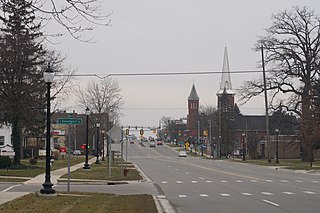
Saline is a city in Washtenaw County in the U.S. state of Michigan. The population was 8,948 at the 2020 census. The city borders Saline Township to the southwest, and the two are administered autonomously.

<span class="mw-page-title-main">Gilliam, Missouri</span> City in Missouri, United States

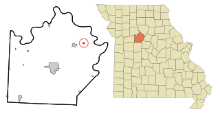
Gilliam is a city in Saline County, Missouri, United States. The population was 197 at the 2010 census.

<span class="mw-page-title-main">Miami, Missouri</span> City in Missouri, United States

Miami is a city in Saline County, Missouri, United States. The population was 175 at the 2010 census.

<span class="mw-page-title-main">Nelson, Missouri</span> City in Missouri, United States

Nelson is a city in Saline County, Missouri, United States. The population was 152 at the 2020 census.

<span class="mw-page-title-main">Wilber, Nebraska</span> City in Saline County, Nebraska, United States

Wilber is a city in and the county seat of Saline County, Nebraska, United States. The population was 1,855 at the 2010 census. It is the county seat of Saline County. Wilber is the official "Czech Capital of the USA" and hosts an annual Czech festival in August. Wilber's school is the Wilber-Clatonia High School.

<span class="mw-page-title-main">Bryant, South Dakota</span> City in South Dakota, United States

Bryant is a city in Hamlin County, South Dakota, United States. It is part of the Watertown, South Dakota Micropolitan Statistical Area. The population was 471 at the 2020 census.

<span class="mw-page-title-main">Esperance, Washington</span> CDP in Washington, United States

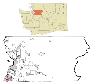
Esperance is a census-designated place (CDP) in Snohomish County, Washington, United States. Esperance is an enclave of the city of Edmonds, Washington. The population was 4,007 at the 2020 census, up from 3,601 at the 2010 census.

<span class="mw-page-title-main">Blackburn, Missouri</span> City in Missouri, United States

Blackburn is a city in Lafayette and Saline counties in the U.S. state of Missouri and is part of the Kansas City metropolitan area. The population was 224 at the 2020 census.

References

  1. "2020 U.S. Gazetteer Files". United States Census Bureau. Retrieved October 29, 2021.
  2. 1 2 U.S. Geological Survey Geographic Names Information System: Bryant, Arkansas
  3. "Annual Estimates of the Population for All Incorporated Places in Arkansas". 2005 Population Estimates. U.S. Census Bureau, Population Division. June 21, 2006. Archived from the original (CSV) on October 15, 2006. Retrieved November 16, 2006.
  4. 1 2 "Encyclopedia of Arkansas". Encyclopedia of Arkansas.
  5. Company, Goodspeed Publishing (April 16, 1889). Biographical and Historical Memoirs: Pulaski, Jefferson, Lonoke, Faulkner, Grant, Saline, Perry, Garland, and Hot Spring Counties, Arkansas. Southern Historical Press. ISBN   9780893080792 via Google Books.
  6. "Census of Population and Housing". Census.gov. Retrieved June 4, 2015.
  7. "Explore Census Data". data.census.gov. Retrieved December 31, 2021.
  8. "U.S. Census website". United States Census Bureau . Retrieved January 31, 2008.
  9. "Community-based program directory Archived January 31, 2011, at the Wayback Machine ." Arkansas Department of Human Services. Retrieved on August 30, 2010. "Arkansas Juvenile Assessment and Treatment Center 1501 Woody Drive Alexander, AR 72002"
  10. "Bryant city, Arkansas [ permanent dead link ]." U.S. Census Bureau. Retrieved on August 30, 2010.
  11. "Post Office™ Location - BRYANT Archived March 5, 2011, at the Wayback Machine ." U.S. Postal Service. Retrieved on March 1, 2011.
  12. "SCHOOL DISTRICT REFERENCE MAP (2010 CENSUS): Saline County, AR" (PDF). U.S. Census Bureau . Retrieved February 28, 2021.