Bauxite, Arkansas

Last updated

Bauxite, Arkansas
Saline County Arkansas Incorporated and Unincorporated areas Bauxite Highlighted 0504090.svg
Location of Bauxite in Saline County, Arkansas.
Coordinates: 34°33′20″N92°31′17″W / 34.55556°N 92.52139°W / 34.55556; -92.52139 [1]
Country United States
State Arkansas
County Saline
Area
[2]
  Total3.13 sq mi (8.10 km2)
  Land3.04 sq mi (7.89 km2)
  Water0.08 sq mi (0.22 km2)
Elevation
[1]
344 ft (105 m)
Population
 (2020)
  Total629
  Density206.57/sq mi (79.77/km2)
Time zone UTC-6 (Central (CST))
  Summer (DST) UTC-5 (CDT)
ZIP code
72011
Area code 501
FIPS code 05-04090

Bauxite is a city in Saline County, Arkansas, United States. Located within Central Arkansas, the city is named for bauxite, the source ore for aluminum, which was found in abundant quantities in the area and became a source of aluminium refining. The city's population boomed during expanded aluminium production during World War II and shrank rapidly with output of the ore. Bauxite was incorporated as a town in 1973. [3] The population was 487 at the 2010 census.

Contents

History

The ore for which the city is named was discovered in the area in the early 1890s and mined by the General Bauxite Company until 1905, when the Pittsburgh Reduction Company, an aluminum refining company, purchased vast tracts of land in Saline County after learning of the high-quality ore that was being shipped from the area. The company bought out the local producers of the ore, including the General Bauxite Company. Pittsburgh Reduction would go on to incorporate as the Aluminum Company of America, or ALCOA.

Production of the ore rose rapidly, growing from 200,000 short tons (180,000 t) in 1914 during World War I, to 560,000 short tons (510,000 t) by war's end in 1918. With decreased demand and an expanded source base in South America, Arkansas production levels fluctuated with demand, dropping as low as 60,000 short tons (54,000 t) per annum in the mid-1930s. [4]

World War I provided the greatest surge in growth for Bauxite, with multiple camps developing in and around the present-day city, often segregated by race or ethnicity, with such camp names as Italy Camp, Mexico Camp, Africa Camp, etc. Throughout the Great Depression, ALCOA provided a standard of living for its employees that was generally un-matched during that period of economic turbulence.

When World War II broke out, Bauxite was again called into martial action, with production rapidly increasing with the need for refined aluminum to produce airplanes and other material. Donald M. Nelson, the Chairman of the WPA, requested that ALCOA president, Arthur V. Davis implement a three-shift, 24-hour production schedule. Davis brought in miners from across the country to keep the mines running continuously. This rapid rise in output led to a 1943 annual production of 6,000,000 short tons (5,400,000 t) of ore. [3]

Production began to slow as the war drew to a close, but the city's population and infrastructure had swelled to include multiple new communities and a larger school district. ALCOA and Reynolds Metal Company continued to refine bauxite in the area, with Reynolds finally ceasing operations in 1981.

Geography

Bauxite is located in Saline County in south central Arkansas. Situated along Arkansas Highway 183 [5] which also runs through Benton and Bryant, Bauxite is bordered on that path by Benton to the west and Bryant to the north. The city is 14 miles southwest of Little Rock. According to the United States Census Bureau, the town has a total area of 2.5 square miles (6.5 km2), of which 2.4 square miles (6.2 km2) is land and 0.1 square miles (0.26 km2) (2.45%) is water.

Demographics

Historical population
CensusPop.Note
1980 433
1990 412−4.8%
2000 4324.9%
2010 48712.7%
2020 62929.2%
U.S. Decennial Census [6]
2018 Estimate [7]

2020 census

Bauxite racial composition [8]
RaceNumberPercentage
White (non-Hispanic)54386.33%
Black or African American (non-Hispanic)335.25%
Native American 50.79%
Asian 50.79%
Pacific Islander 10.16%
Other/Mixed 243.82%
Hispanic or Latino 182.86%

As of the 2020 United States census, there were 629 people, 214 households, and 173 families residing in the town.

2000 census

As of the census [9] of 2000, there were 432 people, 161 households, and 127 families residing in the town. The population density was 180.6 inhabitants per square mile (69.7/km2). There were 171 housing units at an average density of 71.5 per square mile (27.6/km2). The racial makeup of the city was 97.45% White, 0.69% Native American, 0.23% Asian, and 1.62% from two or more races. 2.31% of the population were Hispanic or Latino of any race.

There were 161 households, out of which 37.3% had children under the age of 18 living with them, 62.1% were married couples living together, 14.3% had a female householder with no husband present, and 20.5% were non-families. 17.4% of all households were made up of individuals, and 10.6% had someone living alone who was 65 years of age or older. The average household size was 2.68 and the average family size was 3.05.

In the city, the population was spread out, with 25.9% under the age of 18, 7.6% from 18 to 24, 29.2% from 25 to 44, 24.8% from 45 to 64, and 12.5% who were 65 years of age or older. The median age was 37 years. For every 100 females, there were 94.6 males. For every 100 females age 18 and over, there were 92.8 males.

The median income for a household in the city was $35,347, and the median income for a family was $37,153. Males had a median income of $28,500 versus $24,167 for females. The per capita income for the city was $14,406. About 8.5% of families and 11.0% of the population were below the poverty line, including 15.4% of those under age 18 and 11.3% of those age 65 or over.

Arts and culture

In 1926, ALCOA built a community center in traditional Colonial style to serve as a boarding house and gathering place for the mining community in the town. The structure still stands, and houses the Bauxite Museum, an informal collection of photographs, documents, and mining equipment from the mining era. In 2008, the museum erected "Unsung Heroes," a life-size series of bronze statues sculpted by Gary Alsum at the property's corner. [10] The sculptures depict a traditional mining family, with a man preparing to leave for work at the bauxite mines. [11] The community center is available to the general public for rental and event usage.

As with many cities and towns in Arkansas, football is important in the Bauxite community as both a social event and source of pride for the city's identity. Bauxite High School has a storied football program which began around 1920. The Bauxite Miners football team won 24 conference championships, appeared in two state title games and won the state championship in 1996. Bauxite has produced many standout players throughout its history. George Cole, (1920-1923) who went on to coach and become athletic director at the University of Arkansas, and Leon "Muscles" Campbell (1943-1945) who played for the NFL's Baltimore Colts, Chicago Bears, and Pittsburgh Steelers, both played at Bauxite.

In recent history, head football coach Jon Watson led the Miners for nearly two decades before retiring in 2010. During his coaching career with Bauxite, which lasted from 1990 until his retirement, he compiled a 177-55-1 record. Watson now ranks seventh overall in victories for high school football coaches in Arkansas. [12] The program currently plays in the 7-4A conference of the Arkansas Activities Association.

Government

Bauxite operates under a city council system with a mayor as the presiding executive officer. The current (as of April 6, 2021) mayor is Eddie Jones. Other elected officials include treasurer Renee Chastain, and council members Ron Parsons, John Davis, Ron Ramsey, Deann Watson, and John Simpson.

Politics

As a part of rural Saline County and a bedroom community to Little Rock, Bauxite has an often convoluted political dynamic. Previously represented by Democratic State Senator Shane Broadway and Representative Dawn Creekmoore, in the 2010 election cycle, Bauxite's representation switched to all-Republican with the election of former State Representative Jeremy Hutchinson and Andy Mayberry to the State Senate and House, respectively. In the Bauxite city precinct, Creekmore narrowly lost to Hutchinson 51%-49%, while Mayberry beat his Democratic challenger by a 76% to 24% margin. Democrats Governor Mike Beebe (who was running for re-election) and Broadway, who was running for Lieutenant Governor of the state, each won by at least 20 percentage points in the city during the 2010 election. [13]

Legislative Delegation

DistrictNameParty
State Representative, District 27 Julie Mayberry GOP
State Senator, District 33 Jeremy Hutchinson GOP
United States Congress, District 2 French Hill GOP

Education

Bauxite has three public schools, which belong to the Bauxite School District, an independent school district which was subject to consolidation under Governor Mike Huckabee's school consolidation plan, but managed to maintain its autonomy after a public outcry from the community.[ citation needed ] The school district consists of:

A small portion of the city is in the Bryant School District, [14] which operates Bryant High School.

Notable people

Related Research Articles

<span class="mw-page-title-main">Andersonville, Georgia</span> City in Georgia, United States

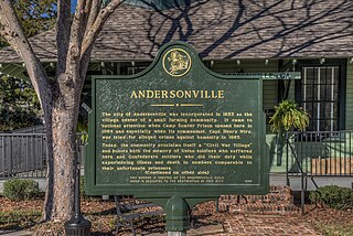
Andersonville is a city in Sumter County, Georgia, United States. As of the 2020 census, the city had a population of 237. It is located in the southwest part of the state, approximately 60 miles (97 km) southwest of Macon on the Central of Georgia railroad. During the American Civil War, it was the site of a prisoner-of-war camp, which is now Andersonville National Historic Site.

<span class="mw-page-title-main">Saline County, Arkansas</span> County in Arkansas, United States

Saline County is located in the U.S. state of Arkansas. As of the 2020 census, the population was 123,416. Its county seat and largest city is Benton. Saline County was formed on November 2, 1835, and named for the salt water (brine) springs in the area, despite a differing pronunciation from saline. Until November 2014, it was an alcohol prohibition or dry county.

<span class="mw-page-title-main">Tull, Arkansas</span> Town in Arkansas, United States

Tull is a town in Grant County, Arkansas, United States. The population was 448 at the 2010 census, up from 358 in 2000. It is part of the Central Arkansas region.

<span class="mw-page-title-main">Paris, Arkansas</span> City in Arkansas, United States

Paris is a city in Logan County, Arkansas, United States, and serves as the county seat for the northern district of Logan County; its southern district counterpart is Booneville. Its population was 3,176 as of the 2020 U.S. Census.

<span class="mw-page-title-main">Alexander, Arkansas</span> City in Arkansas, United States

Alexander is a city in Pulaski and Saline counties in the U.S. state of Arkansas. Located in Central Arkansas, the town was founded as a construction camp for the nearby railroad. Following its completion, the citizens decided to incorporate in 1887. Alexander is home to the Arkansas Juvenile Assessment and Treatment Center. The population was 2,901 at the 2010 census.

<span class="mw-page-title-main">Benton, Arkansas</span> City in Arkansas, United States

Benton is a city in and the county seat of Saline County, Arkansas, United States and a suburb of Little Rock. It was established in 1837. At the 2020 census, the city had a population of 35,014, making it the 12th most populous city in Arkansas. It is part of the Little Rock–North Little Rock–Conway Metropolitan Statistical Area. The city of Benton, first settled in 1833 and named after Missouri Senator Thomas Hart Benton, was formally chartered in 1836 when Arkansas became a state.

<span class="mw-page-title-main">Bryant, Arkansas</span> City in Arkansas, United States

Bryant is a city in Saline County, Arkansas, United States and a suburb of Little Rock. According to the 2010 Census, the population of the city was 16,688. It is part of the Central Arkansas region.

<span class="mw-page-title-main">East End, Arkansas</span> CDP in Arkansas, United States

East End is a census-designated place (CDP) in Saline County, Arkansas, United States. The population was 6,998 at the 2010 census. It is part of the Little Rock–North Little Rock–Conway Metropolitan Statistical Area.

<span class="mw-page-title-main">Salem, Saline County, Arkansas</span> CDP in Arkansas, United States

Salem is a census-designated place (CDP) in Saline County, Arkansas, United States. Per the 2020 census, the population was 2,544. It is part of the Little Rock–North Little Rock–Conway Metropolitan Statistical Area.

<span class="mw-page-title-main">Shannon Hills, Arkansas</span> City in Arkansas, United States

Shannon Hills is a city in Saline County, Arkansas, United States. The population was 3,143 at the 2010 census, rising to 4,490 with the 2020 census. It is part of the Little Rock–North Little Rock–Conway Metropolitan Statistical Area.

<span class="mw-page-title-main">Beacon, Iowa</span> City in Iowa, United States

Beacon is a city in Mahaska County, Iowa, United States. The population was 445 at the 2020 census.

<span class="mw-page-title-main">Virginia, Minnesota</span> City in Minnesota, United States

Virginia is a city in St. Louis County, Minnesota, United States, on the Mesabi Iron Range. With an economy heavily reliant on large-scale iron ore mining, Virginia is considered the Mesabi Range's commercial center. The population was 8,423 people at the 2020 census. Virginia is a part of the Duluth metropolitan area, and U.S. Highway 53 runs through town.

<span class="mw-page-title-main">Aurora, Missouri</span> City in Missouri, United States

Aurora is a city in Lawrence County, Missouri, United States. As of the 2020 census, the population of the city was 7,432.

<span class="mw-page-title-main">Alcoa, Tennessee</span> City in Tennessee, United States

Alcoa is a city in Blount County, Tennessee, United States. Its population was 10,978 at the 2020 census. It is part of the Knoxville, TN Metropolitan Statistical Area.

<span class="mw-page-title-main">Rockdale, Texas</span> City in Texas, United States

Rockdale is a city in Milam County, Texas, United States. Its population was 5,323 at the 2020 census. It is approximately 41 miles west of College Station.

<span class="mw-page-title-main">Republic, Washington</span> City in Washington, United States

Republic is a city in Ferry County, Washington, United States. The population was 1,073 at the 2010 census, a 12.5% increase over the 2000 census. It is the county seat of Ferry County. It was the largest mining camp in the Republic Mining District, and home to the "Hot Air Line" railway.

<span class="mw-page-title-main">Atlantic City, Wyoming</span> CDP in Wyoming, United States

Atlantic City is a census-designated place (CDP) in Fremont County, Wyoming, United States. The population was 37 at the 2010 census. The community is a small mining settlement in a gulch near South Pass in southwestern Wyoming. It was founded as a mining camp following the 1867 gold rush in the region. The town declined following the end of the placer gold rush in the early 1870s, but continued to exist as advances in mining technology allowed further extraction of gold. From the 1960s until 1983, it was the location of US Steel iron ore mine. The town is accessible by gravel roads from nearby Wyoming Highway 28.

<span class="mw-page-title-main">Platteville, Wisconsin</span> City in Wisconsin, United States

Platteville is the largest city in Grant County, Wisconsin. The population was 11,836 at the 2020 census, up from 11,224 at the 2010 census. Much of this growth is likely due to the enrollment increase of the University of Wisconsin–Platteville. It is the principal city of the Platteville Micropolitan Statistical area, which has an estimated population of 51,938. Platteville is located atop the greater Platte River valley in the southern Driftless Region of Wisconsin, an area known for its karst topography and rolling hills.

Bauxite High School (BHS) is a comprehensive public high school located in Bauxite, Arkansas, United States. It is one of five public high schools in Saline County and the only senior high school administered by the Bauxite School District.

<span class="mw-page-title-main">Gibson, Arkansas</span> CDP in Arkansas, United States

Gibson is a census-designated place (CDP) in Pulaski County, Arkansas, United States. The population was 3,543 at the 2010 census. It is part of the Little Rock–North Little Rock–Conway Metropolitan Statistical Area.

References

  1. 1 2
  2. "2020 U.S. Gazetteer Files". United States Census Bureau. Retrieved October 29, 2021.
  3. 1 2 3 Harrington, Laura (October 12, 2011). "Bauxite (Saline County)". Encyclopedia of Arkansas History & Culture . Little Rock, AR: Butler Center for Arkansas Studies at the Central Arkansas Library System . Retrieved January 25, 2015.
  4. Bush, William V. (2007). "History of Bauxite in Arkansas". Arkansas Geological Survey.{{cite journal}}: Cite journal requires |journal= (help)
  5. Arkansas Atlas & Gazeteer, DeLorme, 2nd ed., 2004, p.49 ISBN   0899333451
  6. "Census of Population and Housing". Census.gov. Retrieved June 4, 2015.
  7. "Population Estimates". United States Census Bureau . Retrieved June 8, 2018.
  8. "Explore Census Data". data.census.gov. Retrieved December 31, 2021.
  9. "U.S. Census website". United States Census Bureau . Retrieved January 31, 2008.
  10. "Bauxite Miners Honored with Statue". TodaysTHV.com. October 19, 2008.
  11. "Unsung Heroes". Arkansas Democrat-Gazette, Tri-Lakes Edition. October 23, 2008.
  12. 501 Football Extra: Bauxite Miners. Retrieved June 14, 2011.
  13. Arkansas Secretary of State. "Vote Naturally: Past Election Results, 2004 - Present". Retrieved June 14, 2011.
  14. "SCHOOL DISTRICT REFERENCE MAP (2010 CENSUS): Saline County, AR" (PDF). U.S. Census Bureau . Retrieved February 28, 2021.