Scott is an unincorporated community and census-designated place (CDP) in Lonoke and Pulaski counties in the central part of the U.S. state of Arkansas. Per the 2020 census, the population was 97. It is part of the Little Rock–North Little Rock–Conway Metropolitan Statistical Area.

Hensley is a census-designated place (CDP) in Pulaski County, Arkansas, United States. The population was 139 at the 2010 census. It is part of the Little Rock–North Little Rock–Conway Metropolitan Statistical Area.

Landmark is a census-designated place (CDP) in Pulaski County, Arkansas, United States. Per the 2020 census, the population was 3,585. It is part of the Little Rock–North Little Rock–Conway Metropolitan Statistical Area.

East End is a census-designated place (CDP) in Saline County, Arkansas, United States. The population was 6,998 at the 2010 census. It is part of the Little Rock–North Little Rock–Conway Metropolitan Statistical Area.

Salem is a census-designated place (CDP) in Saline County, Arkansas, United States. Per the 2020 census, the population was 2,544. It is part of the Little Rock–North Little Rock–Conway Metropolitan Statistical Area.
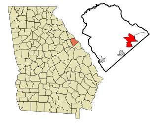
Evans is an unincorporated community and census-designated place (CDP) in Columbia County, Georgia, United States. It is a suburb of Augusta and is part of the Augusta metropolitan area. The population was 29,011 at the 2010 census, up from 17,727 at the 2000 census.

El Paso is an unincorporated community and census-designated place (CDP) in southwestern White County, Arkansas, United States. It was first listed as a CDP in the 2020 census with a population of 267. Its name is Spanish for "the pass", referring to a small gap in the hills on the community's northern edge. Once known as Peach Orchard Gap in its early settlement, the origin of El Paso's Spanish name is unknown.
Alpine is an unincorporated community and census-designated place (CDP) in Clark County, Arkansas, United States, approximately eight miles east of Amity. The community center located in its heart is a popular draw for Clark County citizens during Christmas, 4th of July and Halloween celebrations annually.
University is a census-designated place (CDP) and unincorporated community in Orange County, Florida, United States, east of Orlando. The community is centered around the University of Central Florida and includes a location on its south side known as University Park. It is part of the Orlando–Kissimmee–Sanford, Florida Metropolitan Statistical Area. As of 2020, the CDP had a population of 45,284.
Dora is an unincorporated community and census-designated place (CDP) in Crawford County in the western part of the U.S. state of Arkansas. It is located approximately three miles west of Van Buren on the Arkansas-Oklahoma border along Interstate 40. The community is part of the Fort Smith, Arkansas-Oklahoma Metropolitan Statistical Area. Dora shares its ZIP code (72956) and other municipal services with Van Buren.

New Blaine is an unincorporated community and census-designated place (CDP) in Logan County, Arkansas, United States. Per the 2020 census, the population was 173.
Cincinnati is an unincorporated community and census-designated place (CDP) in northwestern Washington County, Arkansas, United States. It was first listed as a CDP in the 2020 census with a population of 306.
Buffalo City is an unincorporated community and census-designated place (CDP) in Baxter County, Arkansas, United States. It was first listed as a CDP in the 2020 census with a population of 26.

Yarborough Landing is a census-designated place in Little River County, Arkansas, United States. Per the 2020 census, the population was 457.
Boles is an unincorporated community and census-designated place (CDP) in Scott County, Arkansas, United States. It was first listed as a CDP in the 2020 census with a population of 166.
Board Camp is an unincorporated community and census-designated place (CDP) in Polk County, Arkansas, United States. Board Camp is located on Arkansas Highway 8, 8.5 miles (13.7 km) east-southeast of Mena. Board Camp has a post office with ZIP code 71932.
Urbana is an unincorporated community and census-designated place (CDP) in Union County, Arkansas, United States. Urbana is 13 miles (21 km) east-southeast of El Dorado. Urbana has a post office with ZIP code 71768. It was first listed as a CDP in the 2020 census with a population of 177.
Pleasant Grove is an unincorporated community and census-designated place (CDP) in Stone County, Arkansas, United States. It was first listed as a CDP in the 2020 census with a population of 235. Pleasant Grove is located along Arkansas Highway 14, 12.5 miles (20.1 km) east-southeast of Mountain View. Pleasant Grove has a post office with ZIP code 72567.
Gamalielgə-MAIL-ee-ə is an unincorporated community and census-designated place (CDP) in Baxter County, Arkansas, United States. Gamaliel is located along Arkansas Highway 101, 12 miles (19 km) northeast of Mountain Home and 3 mi (4.8 km) south of the Arkansas—Missouri border. Gamaliel has a post office with ZIP code 72537.
Bethesda was an unincorporated community and census-designated place (CDP) in western Independence County, Arkansas, United States. It was first listed as a CDP in the 2020 census with a population of 199.


