
A stratovolcano, also known as a composite volcano, is a conical volcano built up by many layers (strata) of hardened lava and tephra. Unlike shield volcanoes, stratovolcanoes are characterized by a steep profile with a summit crater and periodic intervals of explosive eruptions and effusive eruptions, although some have collapsed summit craters called calderas. The lava flowing from stratovolcanoes typically cools and solidifies before spreading far, due to high viscosity. The magma forming this lava is often felsic, having high to intermediate levels of silica, with lesser amounts of less viscous mafic magma. Extensive felsic lava flows are uncommon, but have traveled as far as 15 km (9 mi).

A flood basalt is the result of a giant volcanic eruption or series of eruptions that covers large stretches of land or the ocean floor with basalt lava. Many flood basalts have been attributed to the onset of a hotspot reaching the surface of the Earth via a mantle plume. Flood basalt provinces such as the Deccan Traps of India are often called traps, after the Swedish word trappa, due to the characteristic stairstep geomorphology of many associated landscapes.
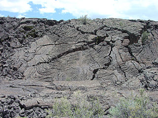
El Malpais National Monument is a National Monument located in western New Mexico, in the Southwestern United States. The name El Malpais is from the Spanish term Malpaís, meaning badlands, due to the extremely barren and dramatic volcanic field that covers much of the park's area.

The Taos Plateau volcanic field is an area of extensive volcanism in Taos County, New Mexico, United States. It is the largest volcanic field in the Rio Grande Rift, spreading over 7,000 square kilometers (2,700 sq mi). The total erupted volume is estimated at 420 cubic kilometers (100 cu mi). The age of most of the vents and associated lava flows in the field is estimated to be between 1.8 and 4 million years, with a few 22-million-year-old vents. The composition of the lavas varies from tholeiitic basalt to rhyolite. Landforms include sheet flows, cinder cones, and shield volcanoes. The sheet flows of the Servilleta Basalt are well-exposed in the Rio Grande Gorge carved by the Rio Grande. The highest point of the field is San Antonio Mountain at 10,908 feet (3,325 m).

The Northern Cordilleran Volcanic Province (NCVP), formerly known as the Stikine Volcanic Belt, is a geologic province defined by the occurrence of Miocene to Holocene volcanoes in the Pacific Northwest of North America. This belt of volcanoes extends roughly north-northwest from northwestern British Columbia and the Alaska Panhandle through Yukon to the Southeast Fairbanks Census Area of far eastern Alaska, in a corridor hundreds of kilometres wide. It is the most recently defined volcanic province in the Western Cordillera. It has formed due to extensional cracking of the North American continent—similar to other on-land extensional volcanic zones, including the Basin and Range Province and the East African Rift. Although taking its name from the Western Cordillera, this term is a geologic grouping rather than a geographic one. The southmost part of the NCVP has more, and larger, volcanoes than does the rest of the NCVP; further north it is less clearly delineated, describing a large arch that sways westward through central Yukon.

Magmatism is the emplacement of magma within and at the surface of the outer layers of a terrestrial planet, which solidifies as igneous rocks. It does so through magmatic activity or igneous activity, the production, intrusion and extrusion of magma or lava. Volcanism is the surface expression of magmatism.

The Raton-Clayton volcanic field is a volcanic field located in the state of New Mexico, United States. Capulin Volcano National Monument is located in the volcanic field. It is the northeasternmost volcanic field of the Jemez Lineament and the easternmost Cenozoic volcanic field of North America.

The Jemez Lineament is a chain of late Cenozoic volcanic fields, 800 kilometers (500 mi) long, reaching from the Springerville and White Mountains volcanic fields in East-Central Arizona to the Raton-Clayton volcanic field in Northeastern New Mexico.

The Wells Gray-Clearwater volcanic field, also called the Clearwater Cone Group, is a potentially active monogenetic volcanic field in east-central British Columbia, Canada, located approximately 130 km (81 mi) north of Kamloops. It is situated in the Cariboo Mountains of the Columbia Mountains and on the Quesnel and Shuswap Highlands. As a monogenetic volcanic field, it is a place with numerous small basaltic volcanoes and extensive lava flows.
Volcanic activity, or volcanism, has played a significant role in the geologic evolution of Mars. Scientists have known since the Mariner 9 mission in 1972 that volcanic features cover large portions of the Martian surface. These features include extensive lava flows, vast lava plains, and the largest known volcanoes in the Solar System. Martian volcanic features range in age from Noachian to late Amazonian, indicating that the planet has been volcanically active throughout its history, and some speculate it probably still is so today. Both Mars and Earth are large, differentiated planets built from similar chondritic materials. Many of the same magmatic processes that occur on Earth also occurred on Mars, and both planets are similar enough compositionally that the same names can be applied to their igneous rocks.

Cape Verde is a volcanic archipelago situated above an oceanic rise that puts the base of the islands 2 kilometers (1.2 mi) above the rest of the seafloor. Cape Verde has been identified as a hotspot and the majority of geoscientists have argued that the archipelago is underlain by a mantle plume and that this plume is responsible for the volcanic activity and associated geothermal anomalies.

The Dunedin Volcano is an extensively eroded multi-vent shield volcano that was active between 16 and 10 million years ago. It originally extended from the modern city of Dunedin, New Zealand to Aramoana about 25 km away. Extensive erosion has occurred over the last 10 million years and Otago Harbour now fills the oldest parts of the volcano. The remnants of the volcano form the hills around Otago Harbour.

The San Quintín Volcanic Field is a collection of ten or eleven volcanic cinder cones situated along the Pacific coast of the Baja California peninsula in Mexico. The field formed by repeated eruptions beginning in the Pleistocene and ending about 3000 years ago. It is one of several known Quaternary period volcanic fields in Baja. The lava shields appear to have first grown as subaqueous volcanoes that emerged as islands.
A continental arc is a type of volcanic arc occurring as an "arc-shape" topographic high region along a continental margin. The continental arc is formed at an active continental margin where two tectonic plates meet, and where one plate has continental crust and the other oceanic crust along the line of plate convergence, and a subduction zone develops. The magmatism and petrogenesis of continental crust are complicated: in essence, continental arcs reflect a mixture of oceanic crust materials, mantle wedge and continental crust materials.

The Tengchong Volcanic Field (TVF) is a Cenozoic volcanic field located in the Southeastern margin of the Tibetan Plateau around 40 km from the Chinese border with Myanmar. The TVF is uniquely the only region affected by Quaternary volcanism that is part of the Himalayan Geothermal Belt caused by the Indo-Asian continent-continent collision. The TVF is characterized by hydrothermal activity and large-scale eruptions last recorded in 1609CE. Although the volcanoes themselves are considered extinct, several geothermal fields geographically linked to the TVF are still highly active. Evidence for geothermal activity can be linked to several prevalent active hot-springs located predominantly within the vicinity of the volcanoes in the TVF. Holocene eruptions occurred predominantly in the three largest volcanoes in the TVF named the Dayingshan, Maa'nshan and Heikongshan, the highest of which (Dayingshan) reaches 2865 meters above sea level. The volcanoes are distributed in a string-like pattern clustered from North to South in the middle on the Tengchong basin and are characterized by post-collisional high-Potassium (K) calc-alkaline series eruptions. The TVF provides unique geographical and geological knowledge as understanding the geological processes of creation provides insight into aspects such as the history of volcanism during the Quaternary Era in the region and as well as compositional information of its source and crustal assimilants. The TVF can be visited in the Tengchong Volcanic Geothermal National Geological Park.`

Cima volcanic field is a volcanic field in San Bernardino County, California, close to the border with Nevada. The volcanic field covers a surface area of 600 km2 (230 sq mi) within the Mojave National Preserve west of the Cima Dome and consists of about 40 volcanic cones with about 60 lava flows. The volcanic cones range from simple cones over multi-cratered mountains to eroded hills, and lava flows are up to 9.1 km (5.7 mi) long. At least one lava tube exists in the field and can be visited.

North Arch volcanic field is an underwater volcanic field north of Oahu, Hawaii. It covers an area of about 25,000 square kilometres (9,700 sq mi) and consists of large expanses of alkali basalt, basanite and nephelinite that form extensive lava flows and volcanic cones. Some lava flows are longer than 100 kilometres (62 mi).

Bandera Volcano Ice Cave, also known as Zuni Ice Cave, is a lava tube cave in New Mexico with an internal temperature significantly less than above-ground summertime ambient temperature; it contains perennial ice. The inside temperatures can fluctuate between −1 and 10 °C. Some areas of the ice cave never reach above freezing. For years, local Indigenous people used the cave to store food.

The plate theory is a model of volcanism that attributes all volcanic activity on Earth, even that which appears superficially to be anomalous, to the operation of plate tectonics. According to the plate theory, the principal cause of volcanism is extension of the lithosphere. Extension of the lithosphere is a function of the lithospheric stress field. The global distribution of volcanic activity at a given time reflects the contemporaneous lithospheric stress field, and changes in the spatial and temporal distribution of volcanoes reflect changes in the stress field. The main factors governing the evolution of the stress field are:
- Changes in the configuration of plate boundaries.
- Vertical motions.
- Thermal contraction.
The Dunedin volcanic group is a volcanic group that covers over 7,800 km2 (3,000 sq mi) of Otago in the South Island of New Zealand. It is a recent reclassification of the group previously known as the Waiareka-Deborah volcanic field due to common magma melt ancestries of the Dunedin Volcano with the overlapping alkali basaltic monogenetic volcanic field. Excluded from the group are a group of volcanics of different composition and older age near Oamaru, which have been given the name previously used for the Dunedin group. The older Waiareka-Deborah volcanic field overlaps the new Dunedin volcanic group geographically; though Dunedin Volcano has been well studied from the 1880s since New Zealand's first school of geology was established at the University of Otago, detailed studies of north-central volcanoes such as the Crater near Middlemarch were done much later, and high-quality composition studies still need to be done to properly classify many volcanics near Oamaru.

