A caldera is a large cauldron-like hollow that forms shortly after the emptying of a magma chamber in a volcano eruption. When large volumes of magma are erupted over a short time, structural support for the rock above the magma chamber is gone. The ground surface then collapses into the emptied or partially emptied magma chamber, leaving a large depression at the surface. Although sometimes described as a crater, the feature is actually a type of sinkhole, as it is formed through subsidence and collapse rather than an explosion or impact. Compared to the thousands of volcanic eruptions that occur each century, the formation of a caldera is a rare event, occurring only a few times per century. Only seven caldera-forming collapses are known to have occurred between 1911 and 2016. More recently, a caldera collapse occurred at Kīlauea, Hawaii in 2018.
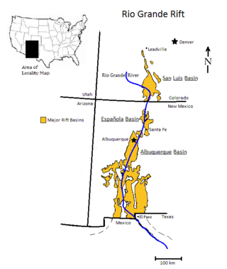
The Rio Grande rift is a north-trending continental rift zone. It separates the Colorado Plateau in the west from the interior of the North American craton on the east. The rift extends from central Colorado in the north to the state of Chihuahua, Mexico, in the south. The rift zone consists of four basins that have an average width of 50 kilometres (31 mi). The rift can be observed on location at Rio Grande National Forest, White Sands National Park, Santa Fe National Forest, and Cibola National Forest, among other locations.

Licancabur is a stratovolcano on the border between Bolivia and Chile, south of the Sairecabur volcano and west of Juriques. Part of the Andean Central Volcanic Zone, it has a prominent, 5,916-metre (19,409 ft)-high cone. A 400-metre (1,300 ft) summit crater containing Licancabur Lake, a crater lake which is among the highest lakes in the world, caps the volcano. Three stages of lava flows emanate from the edifice.

La Garita Caldera is a large caldera in the San Juan volcanic field in the San Juan Mountains around the town of Creede in southwestern Colorado, United States. It is west of La Garita, Colorado. The eruption that created the La Garita Caldera is among the largest known volcanic eruptions in Earth's history, as well as being one of the most powerful known supervolcanic events.

Incahuasi is a volcanic mountain in the Andes of South America. It lies on the border of the Catamarca Province of Argentina and the Atacama Region of Chile. Incahuasi has a summit elevation of 6,621 metres (21,722 ft) above sea level.
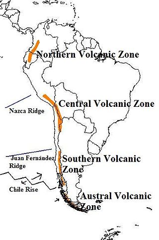
The Andean Volcanic Belt is a major volcanic belt along the Andean cordillera in Argentina, Bolivia, Chile, Colombia, Ecuador, and Peru. It is formed as a result of subduction of the Nazca Plate and Antarctic Plate underneath the South American Plate. The belt is subdivided into four main volcanic zones which are separated by volcanic gaps. The volcanoes of the belt are diverse in terms of activity style, products, and morphology. While some differences can be explained by which volcanic zone a volcano belongs to, there are significant differences within volcanic zones and even between neighboring volcanoes. Despite being a type location for calc-alkalic and subduction volcanism, the Andean Volcanic Belt has a broad range of volcano-tectonic settings, as it has rift systems and extensional zones, transpressional faults, subduction of mid-ocean ridges and seamount chains as well as a large range of crustal thicknesses and magma ascent paths and different amounts of crustal assimilations.
Springerville volcanic field is a monogenetic volcanic field located in east-central Arizona between Springerville and Show Low. The field consists of 405 discrete vents covering approximately 3,000 square kilometers (1,200 sq mi) and is the third-largest such field in the continental United States; only the San Francisco volcanic field and Medicine Lake volcanic field are larger. The total erupted volume is estimated at 90 cubic kilometers (22 cu mi).

The Raton-Clayton volcanic field is a volcanic field located in the state of New Mexico, United States. Capulin Volcano National Monument is located in the volcanic field. It is the northeasternmost volcanic field of the Jemez Lineament and the easternmost Cenozoic volcanic field of North America.

The Jemez Lineament is a chain of late Cenozoic volcanic fields, 800 kilometers (500 mi) long, reaching from the Springerville and White Mountains volcanic fields in East-Central Arizona to the Raton-Clayton volcanic field in Northeastern New Mexico.

The Cochetopa Hills are a ridge of uplands on the Continental Divide in Saguache County, southern Colorado, United States.

This timeline of volcanism on Earth includes a list of major volcanic eruptions of approximately at least magnitude 6 on the Volcanic explosivity index (VEI) or equivalent sulfur dioxide emission during the Quaternary period. Other volcanic eruptions are also listed.
The San Juan volcanic field is part of the San Juan Mountains in southwestern Colorado. It consists mainly of volcanic rocks that form the largest remnant of a major composite volcanic field that covered most of the southern Rocky Mountains in the Middle Tertiary geologic time. There are approximately fifteen calderas known in the San Juan Volcanic Fields; however, it is possible that there are two or even three more in the region.

The Luzon Volcanic Arc is a chain of volcanoes in a north–south line across the Luzon Strait from Taiwan to Luzon. The name "Luzon Volcanic Arc" was first proposed by Carl Bowin et al. to describe a series of Miocene to recent volcanoes due to eastward subduction along the Manila Trench for approximately 1,200 km from the Coastal Range in Taiwan south to southern Mindoro in the Philippines. Islands that form part of the arc are the Eastern Coastal Range of Taiwan, Green Island, Taiwan, Orchid Island, Kaotai Rock, Mavudis or Y'ami Island, Mabudis, Siayan Island, Itbayat Island, Diogo Island, Batan Island, Unnamed volcano Ibuhos, Sabtang Island, Babuyan, Didicas, and Camiguin de Babuyanes. At the south end it terminates on Luzon. The geochemistry of a number of volcanoes along the arc have been measured. There are five distinct geochemical domains within the arc. The geochemistry of the segments verified that the volcanoes are all subduction related. Isotopes and trace elements show unique geochemical characteristics in the north. Geochemical variations northward were due to the subduction of sediments derived from the erosion of continental crust from China and Taiwan.

The Deicke and Millbrig bentonite layers, specifically the potassium bentonite layer, K-bentonite, were formed from a volcanic eruption during the Taconic orogeny during the Late Ordovician on Laurentia, the craton of North America. Researchers are very interested in the eruptions that formed these bentonite layers because they are thought to be some of the largest volcanic eruptions in the last 600 million years of Earth history, and the resulting ash layer for each eruption individually was greater in volume than the Toba eruption. Bentonite is a type of clay that is formed from the weathering of volcanic ash deposits. Some researchers suggested that the ashes were from a volcanic arc that was on a convergent crust boundary. Researchers believe this because the trace element geochemistry of the bentonite shows that its source was a felsic calc-alkalic magmatic source, which is characteristic of volcanism from a continental crust destructive plate margin setting.

El Laco is a volcanic complex in the Antofagasta Region of Chile. It is directly south of the Cordón de Puntas Negras volcanic chain. Part of the Central Volcanic Zone of the Andes, it is a group of seven stratovolcanoes and a caldera. It is about two million years old. The main summit of the volcano is a lava dome called Pico Laco, which is variously reported to be 5,325 metres (17,470 ft) or 5,472 metres (17,953 ft) high. The edifice has been affected by glaciation, and some reports indicate that it is still fumarolically active.
Jotabeche is a Miocene-Pliocene caldera in the Atacama Region of Chile. It is part of the volcanic Andes, more specifically of the extreme southern end of the Central Volcanic Zone (CVZ). This sector of the Andean Volcanic Belt contains about 44 volcanic centres and numerous more minor volcanic systems, as well as some caldera and ignimbrite systems. Jotabeche is located in a now inactive segment of the CVZ, the Maricunga Belt.
The geology of Panama includes the complex tectonic interplay between the Pacific, Cocos and Nazca plates, the Caribbean Plate and the Panama Microplate.

The plate theory is a model of volcanism that attributes all volcanic activity on Earth, even that which appears superficially to be anomalous, to the operation of plate tectonics. According to the plate theory, the principal cause of volcanism is extension of the lithosphere. Extension of the lithosphere is a function of the lithospheric stress field. The global distribution of volcanic activity at a given time reflects the contemporaneous lithospheric stress field, and changes in the spatial and temporal distribution of volcanoes reflect changes in the stress field. The main factors governing the evolution of the stress field are:
- Changes in the configuration of plate boundaries.
- Vertical motions.
- Thermal contraction.

Nevado Tres Cruces is a massif of volcanic origin in the Andes Mountains on the border of Argentina and Chile. It has two main summits, Tres Cruces Sur at 6,748 metres (22,139 ft) and Tres Cruces Centro at 6,629 m (21,749 ft) and a third minor summit, Tres Cruces Norte 6,030 m (19,780 ft). Tres Cruces Sur is the sixth highest mountain in the Andes.
