Micronesia is a subregion of Oceania, consisting of about 2,000 small islands in the Northwestern Pacific Ocean. It has a close shared cultural history with three other island regions: Maritime Southeast Asia to the west, Polynesia to the east, and Melanesia to the south—as well as with the wider community of Austronesian peoples.

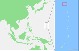
The Northern Mariana Islands, officially the Commonwealth of the Northern Mariana Islands, is an unincorporated territory and commonwealth of the United States consisting of 14 islands in the northwestern Pacific Ocean. The CNMI includes the 14 northernmost islands in the Mariana Archipelago; the southernmost island, Guam, is a separate U.S. territory. The Northern Mariana Islands were listed by the United Nations as a non-self governing territory until 1990.

Saipan is the largest island and capital of the Northern Mariana Islands, a commonwealth of the United States in the western Pacific Ocean. According to 2020 estimates by the United States Census Bureau, the population of Saipan was 43,385, a decline of 10% from its 2010 count of 48,220.
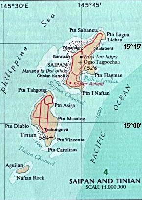
Tinian is one of the three principal islands of the Commonwealth of the Northern Mariana Islands (CNMI). Together with uninhabited neighboring Aguiguan, it forms Tinian Municipality, one of the four constituent municipalities of the Northern Marianas. Tinian's largest village is San Jose. Tinian is just south of the most inhabited island Saipan, but north of the populated Rota to the south. The island is home to many WW2 historical sites, cattle ranches, and beaches. There was a 5-star casino that operated from 1998 to 2015; remaining are other hotels/resorts and a golf course. The main access to Saipan is by a short airplane ride from the international airport, or by a charter boat.

The Mariana Islands, also simply the Marianas, are a crescent-shaped archipelago comprising the summits of fourteen longitudinally oriented, mostly dormant volcanic mountains in the northwestern Pacific Ocean, between the 12th and 21st parallels north and along the 145th meridian east. They lie south-southeast of Japan, west-southwest of Hawaii, north of New Guinea and east of the Philippines, demarcating the Philippine Sea's eastern limit. They are found in the northern part of the western Oceanic sub-region of Micronesia, and are politically divided into two jurisdictions of the United States: the Commonwealth of the Northern Mariana Islands and, at the southern end of the chain, the territory of Guam. The islands were named after the influential Spanish queen Mariana of Austria following their colonization in the 17th century.

Farallón de Pájaros, also known as Uracus or Urracas, is a small (2.3 km2) uninhabited volcanic island, the northernmost island and also farthest west in the Northern Mariana Islands chain.

The Chamorro people are the Indigenous people of the Mariana Islands, politically divided between the United States territory of Guam and the encompassing Commonwealth of the Northern Mariana Islands in Micronesia, a U.S. commonwealth. Today, significant Chamorro populations also exist in several U.S. states, including Hawaii, California, Washington, Texas, Tennessee, Oregon, and Nevada. According to the U.S. Census, they are collectively designated Pacific Islander Americans.

Rota, also known as the "Friendly Island", is the southernmost island of the United States Commonwealth of the Northern Mariana Islands (CNMI) and the third southernmost of the Marianas Archipelago. In early Spanish records it is called "Zarpana"; the name Rota may have come from the Spaniards possibly naming the island after the municipality of Rota, Spain. It lies approximately 40 nautical miles (74 km) north-northeast of the United States territory of Guam. Sinapalo village is the largest and most populated, followed by Songsong village (Songsong). Rota also functions as one of the four municipalities of the CNMI.

Pagan is a volcanic island in the Marianas archipelago in the northwest Pacific Ocean, under the jurisdiction of the Commonwealth of the Northern Mariana Islands. It lies midway between Alamagan to the south and Agrihan to the north. The island has been largely uninhabited ever since most of its 50 residents were evacuated due to volcanic eruptions in 1981.

Anatahan is an island in the Northern Mariana Islands in the Pacific Ocean, and has one of the most active volcanoes of the archipelago. Although formerly inhabited, the island is currently uninhabited due to the constant danger of volcanic eruptions. Anatahan is located 60 kilometers (32 nmi) northwest of Farallon de Medinilla and 120 km (65 nmi) north of Saipan. It last erupted between 2007 and 2008, and also erupted in 2003.

A latte stone, or simply latte, is a pillar capped by a hemispherical stone capital (tasa) with the flat side facing up. Used as building supports by the ancient Chamorro people, they are found throughout most of the Mariana Islands. In modern times, the latte stone is seen as a sign of Chamorro identity and is used in many different contexts.

Asuncion is the third northernmost island in the Northern Mariana Islands chain in the Pacific Ocean. The island is uninhabited. Asuncion is situated 101 kilometers (63 mi) northwest of Agrihan and 37 km (23 mi) southeast of the Maug Islands.

Alamagan is an island in the Northern Mariana Islands in the Pacific Ocean, 30 nautical miles (56 km) north of Guguan, 250 nautical miles (463 km) north of Saipan, and 60 nautical miles (111 km) south of Pagan. It is currently undergoing resettlement since 2018, with a few people living there. The project was coordinated by the Northern Islands Mayor's office and the people there have radio contact with the mainland.

Agrihan is an island in the Northern Mariana Islands in the Pacific Ocean. The island has mostly been uninhabited, but had 4 permanent residents in the 2020 U.S. census. Agrihan is located 62 kilometers (39 mi) to the north of Pagan.

Guguan is an island in the Northern Mariana Islands in the Pacific Ocean. The island is currently uninhabited. Guguan is located 30 nautical miles (56 km) south from Alamagan and 250 nautical miles (463 km) north from Saipan, and is 67 nautical miles (124 km) northeast from Sarigan.

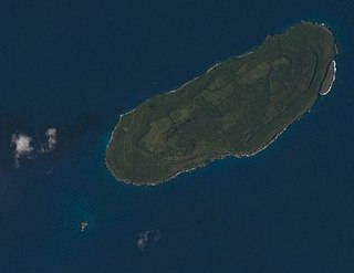
Sarigan or Sariguan is an uninhabited volcanic island in the Pacific Ocean. It is part of the Northern Mariana Islands, a U.S. territory. Sarigan is located 37 kilometers (20 nmi) northeast of Anatahan island, 67 km (36 nmi) south of Guguan and 150 km (81 nmi) north of Saipan, the largest island in the Northern Marianas. The island has been sparsely populated, but in modern times has been uninhabited due to volcanic activity. It is a currently a nature preserve.
Farallon de Medinilla , also known as No'os, is a small uninhabited island in the Northern Mariana Islands in the Pacific Ocean. It is located 45 nautical miles (83 km) north of Saipan and is the smallest island in the archipelago. Politically, it is part of the Northern Islands Municipality.
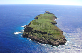
Aguiguan, alternatively it is called Goat Island, is a small bean-shaped uninhabited coralline island in the Northern Mariana Islands chain in the Pacific Ocean. It is situated 8 kilometers (5.0 mi) south-west of Tinian, from which it is separated by the Tinian Channel. Aguiguan and neighboring Tinian Island together form Tinian Municipality, one of the four main political divisions that comprise the Northern Marianas. The island is inhabited by wild goats and the last known habitat of a rare Pacific bat, as well as many species of birds. During WW2 a Japanese garrison was on the island, which surrendered at the end of the War without a battle. Access to the island is inhibited by the lack of a natural harbor.

Guam The following outline is provided as an overview of and topical guide to Guam:
The following outline is provided as an overview of and topical guide to the Northern Mariana Islands: