
Rota, also known as the "Friendly Island", is the southernmost island of the United States Commonwealth of the Northern Mariana Islands (CNMI) and the second southernmost of the Marianas Archipelago. In early Spanish records it is called "Zarpana"; the name Rota may have come from the Spaniards possibly naming the island after the municipality of Rota, Spain. It lies approximately 40 nautical miles (74 km) north-northeast of the United States territory of Guam. Sinapalo village is the largest and most populated, followed by Songsong village (Songsong). Rota also functions as one of the four municipalities of the CNMI.

Fort Mott, located in Pennsville, Salem County, New Jersey, United States, was part of the Harbor Defenses of the Delaware, a three-fort defense system designed for the Delaware River during the postbellum and Endicott program modernization periods following the American Civil War and in the 1890s. The other two forts in the system were Fort Delaware on Pea Patch Island and Fort DuPont in Delaware City, Delaware. It is now part of Fort Mott State Park.
Suicide Cliff is a cliff above Marpi Point Field near the northern tip of Saipan, Northern Mariana Islands, which achieved historic significance late in World War II.
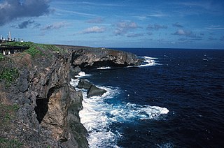
Banzai Cliff is a historical site at the northern tip of Saipan island in the Northern Mariana Islands, overlooking the Pacific Ocean. Towards the end of the Battle of Saipan in 1944, hundreds of Japanese civilians and soldiers jumped off the cliff to their deaths in the ocean and rocks below, to avoid being captured by the Americans. Not far away, a high cliff named Suicide Cliff overlooks the coastal plain, and was another site of numerous suicides. At Banzai Cliff, some who jumped did not die and were captured by American ships.
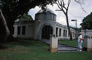
The Japanese Hospital or Saipan Byoin is a historic World War II-era hospital complex on Route 3 in Garapan, a village on the island of Saipan in the Northern Mariana Islands. The three concrete buildings are the largest Japanese-built structures to survive the war. The main hospital building is an L-shaped structure with a domed entrance at the crook of the L. A second, smaller building housed the pharmacy, while the third is an underground circular chamber of unknown purpose. All were in deteriorating condition when surveyed in the early 1970s. The complex has since undergone restoration, and the main hospital building now houses the Northern Mariana Islands Museum.
The Commissioner's Office is a rare surviving example of transitional Spanish-Japanese architecture on the island of Rota in the Northern Mariana Islands, an insular area of the United States in the western Pacific Ocean. It is a single-story structure with walls of manposteria, a construction method adopted during the Spanish period. The window trim consists of ifil lintels, and the building's cornice is Japanese in style. At the time of the building's listing on the National Register of Historic Places in 1981, it was in deteriorated condition, lacking a roof and with one collapsed wall. The structure was built in the 1930s by the local Chamorro people, who had been displaced to that part of the island by Japanese settlement undertaken as part of the South Seas Mandate. The building housed the offices of a local commissioner, or village head responsible to the Japanese authorities. Many buildings built by the Japanese during the mandate period were destroyed in World War II.

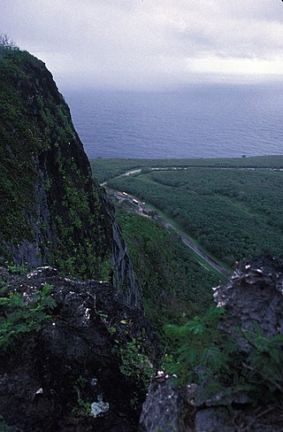
The Chugai' Pictograph Site is a prehistoric rock art site on the island of Rota in the Northern Mariana Islands. The rock art is located in a limestone cave on the southeastern side of the island, in the I'Chenchon Bird Sanctuary. It consists of a large panel, 185 feet (56 m) in length, of about 90 painted drawings, believed to be of late pre-contact origin. The site is accessed via a trail cut by the Japanese during the South Seas Mandate period.

The Campaneyan Kriso Rai, also known as the Catholic Belltower, is a historic church tower in Garapan, the largest village on Saipan island in the Northern Mariana Islands. Built in 1932, it is the only element of the island's most prominent Roman Catholic church to survive bombardment in World War II. The tower, a concrete structure 3 meters (9.8 ft) square and 10 meters (33 ft) tall, was built by Spanish Jesuits brought in by the Japanese South Seas Mandate administration, and stood next to an 1860 wood-frame church.
The Chudang Palii Japanese World War II Defensive Complex is one of the largest surviving World War II defensive establishments in the Northern Mariana Islands. Located at the base of a limestone bluff overlooking the island's airport, it consists of an extensive series of tunnels, walls, enclosures, gun emplacements and other features. These were built in 1944 and 1945, probably with forced labor, after the Japanese decided to embark on a program of in-depth island defenses after Allied successes against defenses that were limited to shore-based establishments. These works are characterized by an extensive use of native materials, and by the use of manual labor to dig tunnels, trenches, and other features.
The Dugi Archeological Site is a prehistoric latte stone site on the north side of Rota Island in the Northern Mariana Islands. The site is a rare inland site that survived the intensive sugar cane development introduced by the Japanese during the South Seas Mandate period of the 1920s and 1930s. It consists of sixteen deteriorated latte stone structures on three high terraces. Some of the latte stones have fallen over and others are missing features normally found at these sites.

The Japanese 20mm Cannon Blockhouse is one of many relics of World War II on the island of Saipan in the Northern Mariana Islands. It is a concrete blockhouse, semi-circular in shape with a diameter of about 6 metres (20 ft). Its walls are 1.22 metres (4.0 ft) thick with four firing ports large enough to accommodate 20mm cannons, originally equipped with steel sliding shutters. A steel door 25 millimetres (0.98 in) thick provides access to the structure at the rear, sheltered by a concrete wall and covered defensively by a machine gun port. The blockhouse is located near the center of what is locally called Big Agingan Beach, on the south coast of the island, about 20 metres (66 ft) from the shore. It was built in some haste by the Japanese forces defending Saipan in 1944, and was captured by Allied forces early in the Battle of Saipan.
The former Japanese Hospital building on the island of Rota in the Northern Mariana Islands is one of the few remaining Japanese-era buildings on the island. It is a single-story L-shaped concrete structure. When listed on the National Register of Historic Places in 1981, it was described as being in derelict condition, being little more than the concrete structure, lacking a roof, windows, and most of its woodwork. The window openings are sheltered by typical Japanese concrete canopies. The building was built by the Japanese about 1930, during the South Seas Mandate period; most Japanese-built structures on Rota were destroyed during World War II.
The Nan'yō Kōhatsu Kabushiki Kaisha complex was the main support base of the Nan'yō Kōhatsu Kabushiki Kaisha (NKKK) on the island Tinian in the Northern Mariana Islands. The NKKK was an economic development company established by the Empire of Japan to develop the territories of the South Seas Mandate, which it oversaw between the First and Second World Wars. In the Northern Marianas, the company aggressively developed arable areas for sugar cane farming, importing workers from Japan, Okinawa, and Korea. Each of the three major islands had major support facility. On Tinian, this area, now roughly where the island's largest community, San Jose is located on the south coast, consisted of an extensive development, most of which was destroyed during the Battle of Tinian in the Second World War. Of this large complex, only four buildings or structures remain, all of which have been listed on the United States National Register of Historic Places, as rare surviving examples of pre-war Japanese architecture on the islands.
The Unai Lagua Japanese Defense Pillbox is one of the more unusual surviving World War II-era Japanese fortifications on the island of Saipan in the Northern Mariana Islands. It is located at the southern end of Unai Lagua, which stretches along the northern shore of the island. The pillbox is fashioned out of poured concrete and coral boulders, and uses natural rock formations as part of its walls. This construction was necessitated by a severe shortage of building materials on the island as the Japanese prepared the island's defenses against the advancing Allied forces in 1943–44. The use of natural materials and terrain had the added benefit of rendering the position nearly invisible to aerial or offshore observation.
The Unai Obyan Latte Site is a prehistoric archaeological site on the island of Saipan in the Northern Mariana Islands. Located near Obyan Beach on the south coast of the island, it is the site of what was once a fairly extensive village, which was significantly disturbed by Japanese defensive preparations during World War II. The site includes the fragmentary remains of a single latte stone house site and a wide scattering of surface-level remains. Excavation of the latte house site in the 1940s by the pioneering archeologist Alexander Spoehr yielded evidence of a length period of occupation. The village at Obyan was documented in early Spanish accounts of the island, and was probably abandoned when the Spanish forcibly relocated the entire island population to Guam in 1698.
The Rectory on the island of Rota in the Northern Mariana Islands is a rare example of transitional Spanish-Japanese architecture in the archipelago, now a United States commonwealth. It was built about 1930, during the South Seas Mandate period of Japanese administration, when the native Chamorro people were displaced to this area by workers imported by the Japanese to work in the sugar fields. The rectory is an L-shaped concrete structure measuring 13.7 by 19.8 metres, and originally had a wood-framed second floor and roof. Although only the concrete frame remains, elements such as its massive steps and window placement are typical of the earlier Spanish period, while decorative elements such as its porch columns and window opening details are distinctly Japanese.

The Nan'yō Kōhatsu Kabushiki Kaisha Sugar Mill is a former industrial facility in the village of Songsong on the island of Rota in the Northern Mariana Islands. Its ruins are a significant reminder of the South Seas Mandate period, when Imperial Japan engaged in large-scale sugar cane farming in the Northern Marianas, and are the only brick structure in the Northern Marianas. The sugar mill on Rota was one of the major installations of the Nan'yō Kōhatsu Kabushiki Kaisha, the Japanese company responsible for economic development of the mandate area. Its Executive Director turned Board Chairman. Haruji Matsue, considered the Northern Mariana Islands, the best place to establish the sugar industry, and more especially since previous Japanese commercial enterprises tried their hand at growing and processing sugar cane, but failed. The Nan'yō Kōhatsu Kabushiki Kaisha, was the most dominant economic force and being the largest Japanese Corporation, came to the Northern Marianas in 1921. Not unlike its predecessors, the NKK experienced a very tough few years, which almost forced the company to cease operations. Things started to take a turn for the better in 1926. By the early 1930s, Matsue proceeded to expand the company's landholdings and operations to Tinian and Rota, respectively. Rota had one mill and 38% of the farmlands had sugar cane growing. The remnants of this sugar mill, all that survived the Allied capture of Rota during World War II, are located on the north side of the peninsula that projects southwest from Songsong, and consist of fragments of brick and concrete structures. The most impressive single element is a brick and concrete tunnel 42.5 metres (139 ft) long, from which openings lead to the locations of other parts of the once-extensive complex.

Mochong is a major prehistoric archaeological site on the island of Rota in the Northern Mariana Islands. It is considered the best preserved and second largest latte village in the Marianas. It is an extensive village site on the northern side of the island comprising 50 individual latte sets, scattered mortars (lusongs), scattered subsurface artifacts such as tools, fishing implements and abundance pieces of pottery; the Marianas Red Ware Pottery and the Marianas Plain Ware Pottery. This site also includes an extremely rare latte house structure consisting of 14 columns. It also has a latte stone wall, consisting of six columns and five slabs, that is more than 50 feet (15 m) long. The site has been radiocarbon dated to c. 1000 BCE. The site was first sketched in the early 19th century by the French explorer Louis de Freycinet, and was in remarkably intact condition in the 1980s.

The Gongna Beach defenses are a collection of World War II structures built on or near Gongna Beach in Tamuning on the island of Guam, now a United States territory. These defenses were erected by the Imperial Japanese Army during its occupation of the island 1941–44. The three surviving elements were listed on the National Register of Historic Places in 1991. They are located well north of the main Allied landing areas of the 1944 Battle of Guam.
The Pago Bay Japanese pillboxes are a pair of World War II-era coastal defense pillboxes located on the shore of Pago Bay, located on the central east coast of Guam. Built out of steel-reinforced concrete mixed with coral stone, these two structures were built by Japanese defenders during their occupation of the island between 1941 and 1944. They were listed on the National Register of Historic Places in 1991 as Pagu' Pillbox I and Pagu' Pillbox II. Neither of these would have seen substantial action during the 1944 liberation of Guam, whose military activities were focused on the western, central, and northern parts of the island.


