The Northern Mariana Islands, officially the Commonwealth of the Northern Mariana Islands, is an unincorporated territory and commonwealth of the United States consisting of 14 islands in the northwestern Pacific Ocean. The CNMI includes the 14 northernmost islands in the Mariana Archipelago; the southernmost island, Guam, is a separate U.S. territory. The Northern Mariana Islands were listed by the United Nations as a non-self governing territory until 1990.

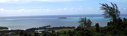
Saipan is the largest island and capital of the Northern Mariana Islands, a commonwealth of the United States in the western Pacific Ocean. According to 2020 estimates by the United States Census Bureau, the population of Saipan was 43,385, a decline of 10% from its 2010 count of 48,220.
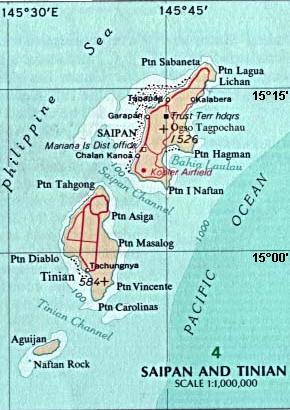
Tinian is one of the three principal islands of the Commonwealth of the Northern Mariana Islands. Together with uninhabited neighboring Aguiguan, it forms Tinian Municipality, one of the four constituent municipalities of the Northern Marianas. Tinian's largest village is San Jose. Tinian is just south of the most inhabited island Saipan, but north of the populated Rota to the south. The island is home to many WW2 historical sites, cattle ranches, and beaches. There was a 5-star casino that operated from 1998 to 2016; remaining are other hotels/resorts and a golf course. The main access to Saipan is by a short airplane ride from the international airport, or by a charter boat.

Rota, also known as the "Friendly Island", is the southernmost island of the United States Commonwealth of the Northern Mariana Islands (CNMI) and the third southernmost of the Marianas Archipelago. In early Spanish records it is called "Zarpana"; the name Rota may have come from the Spaniards possibly naming the island after the municipality of Rota, Spain. It lies approximately 40 nautical miles (74 km) north-northeast of the United States territory of Guam. Sinapalo village is the largest and most populated, followed by Songsong village (Songsong). Rota also functions as one of the four municipalities of the CNMI.

Pagan is a volcanic island in the Marianas archipelago in the northwest Pacific Ocean, under the jurisdiction of the Commonwealth of the Northern Mariana Islands. It lies midway between Alamagan to the south, and Agrihan to the north. The island has been largely uninhabited ever since most of the residents were evacuated due to volcanic eruptions in 1981.

Garapan is the largest village and the center of the tourism industry on the island of Saipan, which is a part of the United States Commonwealth of the Northern Mariana Islands (CNMI). Garapan, as a census-designated place, has an area of 1.2 km2 (0.46 sq mi) and a population of 3,588.

Susupe is a village on Saipan, Northern Mariana Islands. Susupe is also known as Susupi. As of 2000, its population is 2,083.

Commonwealth of the Northern Mariana Islands Public School System is a school district serving the Northern Mariana Islands, a United States territory.
The following outline is provided as an overview of and topical guide to the Northern Mariana Islands:

Chalan Kanoa is one of the settlements on Saipan, the largest of the Northern Mariana Islands. It is located in the southwest of the island. The village contains the island's central post office, as well as the historic Our Lady of Mount Carmel Cathedral and Mount Carmel School, directed by the Spanish Mercedarian Missionaries of Berriz. Once a separate village, it is now virtually contiguous with other nearby villages on Beach Road, including Susupe and San Antonio.

The Refaluwasch people are a Micronesian ethnic group who originated in Oceania, in the Caroline Islands, with a total population of over 8,500 people in northern Mariana. They are also known as Remathau in the Yap's outer islands. The Carolinian word means "People of the Deep Sea." It is thought that their ancestors may have originally immigrated from Asia and Melanesia to Micronesia around 2,000 years ago. Their primary language is Carolinian, called Refaluwasch by native speakers, which has a total of about 5,700 speakers. The Refaluwasch have a matriarchal society in which respect is a very important factor in their daily lives, especially toward the matriarchs. Most Refaluwasch are of the Roman Catholic faith.
Sinapalo or Sinapalu is a village on the island of Rota in the Northern Mariana Islands. The village is the largest settlement on the island, located south of the island's airport, Rota International Airport, close to the center of the island.
San Vicente is a village on Saipan in the Northern Mariana Islands. It is located on the eastern side close to the shore of Magicienne Bay, to the south of the island's highest point, Mount Tapochau. It is connected via the cross-island road to Susupe in the west and with Capitol Hill and Tanapag to the north.
San Antonio is a settlement in Saipan, in the Northern Mariana Islands. It is close to the southwestern tip of the island. Once a separate village, it is now virtually contiguous with other nearby villages on Beach Road, including Susupe, Chalan Kanoa and Chalan Piao.
San Roque is a settlement in Saipan, in the Northern Mariana Islands. It is located to the north of Tanapag on the island's northwest coast, close to the point where the barrier reef protecting the Tanapag Harbor joins to the island. It is connected to Tanapag by the Marpi Road, which runs the length of the northwestern coast.

Marianas High School (MHS) is a public high school located in Susupe on Saipan in the United States Commonwealth of the Northern Mariana Islands (CNMI). It is one of six high schools operated by the CNMI Public School System, and the largest of three public high schools serving the island of Saipan.
The Maritime Heritage Trail – Battle of Saipan is located within the protected waters of Saipan lagoon in the Northern Marianas archipelago. The majority of the dive sites including two Japanese shipwrecks, two Japanese aircraft, two US aircraft, a US landing vehicle and two Japanese landing craft can be found in the clear waters between Garapan, Tanapag Harbor, and Mañagaha Island while further south in Chalan Kanoa Lagoon there are three US tanks.

Gun laws in the Northern Mariana Islands regulate the sale, possession, and use of firearms and ammunition in the Commonwealth of the Northern Mariana Islands. As the Northern Mariana Islands is a commonwealth of the United States, many federal laws apply, as well as Constitutional rulings and protections.
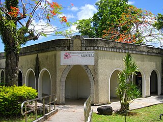
The NMI Museum of History and Culture, also known as the NMI Museum, is a museum in Garapan, Saipan hosting exhibitions about the Chamorro and Carolinian people and also displays artifacts, documents, textiles, and photographs from the Spanish, German, Japanese, and American periods in the Northern Mariana Islands. The museum has repatriated a significant number of historic objects from the Marianas that were held nationally and internationally in private collections and by foreign museums, companies, and militaries. More than one million dollars has been invested in its collections. The historical buildings on the grounds have been renovated to preserve them, prevent further deterioration, and safeguard visitors. The museum is located across from Sugar King Park.