Related Research Articles

Saipan is the largest island of the Northern Mariana Islands, a commonwealth of the United States in the western Pacific Ocean. According to 2020 estimates by the United States Census Bureau, the population of Saipan was 43,385, a decline of 10% from its 2010 count of 48,220.

Rota, also known as the "Friendly Island", is the southernmost island of the United States Commonwealth of the Northern Mariana Islands (CNMI) and the second southernmost of the Marianas Archipelago. In early Spanish records it is called "Zarpana"; the name Rota may have come from the Spaniards possibly naming the island after the municipality of Rota, Spain. It lies approximately 40 nautical miles (74 km) north-northeast of the United States territory of Guam. Sinapalo village is the largest and most populated, followed by Songsong village (Songsong). Rota also functions as one of the four municipalities of the CNMI.

The Roman Catholic Diocese of Chalan Kanoa is an ecclesiastical territory or diocese of the Catholic Church in the United States. It comprises the territory of the Commonwealth of the Northern Mariana Islands and is a suffragan of the Metropolitan Archdiocese of Agaña. The diocese was canonically erected on 8 November 1984 by Pope John Paul II. Its territories were taken from the archdiocese based in Guam.

Pagan is a volcanic island in the Marianas archipelago in the northwest Pacific Ocean, under the jurisdiction of the Commonwealth of the Northern Mariana Islands. It lies midway between Alamagan to the south, and Agrihan to the north. The island has been largely uninhabited ever since most of the residents were evacuated due to volcanic eruptions in 1981.

Garapan is the largest village and the center of the tourism industry on the island of Saipan, which is a part of the United States Commonwealth of the Northern Mariana Islands (CNMI). Garapan, as a census-designated place, has an area of 1.2 km2 (0.46 sq mi) and a population of 3,588.
Northern Islands Municipality is one of the four main political divisions of the Commonwealth of the Northern Mariana Islands. It consists of a long string of the northernmost islands of the Northern Marianas, including Farallon de Pajaros, the Maug Islands, Asuncion, Agrihan, Pagan, Alamagan, Guguan, Zealandia Bank, Sarigan, Anatahan, and Farallon de Medinilla. The total land area of the islands, including offshore islets and rocks, is 154.755 km².

Susupe is a village on Saipan, Northern Mariana Islands. Susupe is also known as Susupi. As of 2000, its population is 2,083.
Chalan Piao is a village on the southwestern area of Saipan. Commonwealth of the Northern Mariana Islands. It is bordered on the north by Chalan Kanoa, on the east by As Perdido village and on the south by San Antonio village. To the west is the Pacific Ocean.

Commonwealth of the Northern Mariana Islands Public School System is a school district serving the Northern Mariana Islands, a United States territory.

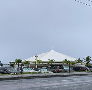
Chalan Kanoa is one of the settlements on Saipan, the largest of the Northern Mariana Islands. It is located in the southwest of the island. The village contains the island's central post office, as well as the historic Our Lady of Mount Carmel Cathedral and Mount Carmel School, directed by the Spanish Mercedarian Missionaries of Berriz. Once a separate village, it is now virtually contiguous with other nearby villages on Beach Road, including Susupe and San Antonio.
Sinapalo or Sinapalu is a village on the island of Rota in the Northern Mariana Islands. The village is the largest settlement on the island, it is located south of the island's airport, Rota International Airport, close to the centre of the island.
San Vicente is a village on Saipan in the Northern Mariana Islands. It is located on the eastern side close to the shore of Magicienne Bay, to the south of the island's highest point, Mount Tapochau. It is connected via the cross-island road to Susupe in the west and with Capitol Hill and Tanapag to the north.
Laolao Bay is a large bay on the southeast side of Saipan in the Northern Mariana Islands.

Capitol Hill is a settlement on the island of Saipan in the Northern Mariana Islands. It has a population of just over 1,000. Capitol Hill has been the territory's seat of government since 1962. It lies on the cross-island road between Tanapag and San Vicente.
Tanapag is a settlement on the island of Saipan in the Northern Mariana Islands. It is located close to Tanapag Beach on the northwest coast, just to the north of Capital Hill, the island group's center of government. It lies on the Marpi Road, which stretches the length of the island's northwest coast.
San Roque is a settlement in Saipan, in the Northern Mariana Islands. It is located to the north of Tanapag on the island's northwest coast, close to the point where the barrier reef protecting the Tanapag Harbor joins to the island. It is connected to Tanapag by the Marpi Road, which runs the length of the northwestern coast.
Francisco Castro Ada was a Northern Mariana Islander politician who served as the first lieutenant governor of the Northern Mariana Islands from January 9, 1978 to January 11, 1982, under Carlos S. Camacho, the territory's first governor.
The Episcopal Church in Micronesia is a mission within Province VIII of the Episcopal Church. It has four congregations, three on Guam and one on Saipan, in the Commonwealth of the Northern Mariana Islands, as well as St. John's Episcopal School in Upper Tumon, Guam. The 2021 parochial reports indicated two parishes and 218 members.
Joeten-Kiyu Public Library is the State Library of the Commonwealth of the Northern Mariana Islands.
References
- ↑ "CNMI PUBLIC SCHOOLS." Commonwealth of the Northern Mariana Islands Public School System. February 24, 2008. Retrieved on January 1, 2018.