The Federated States of Micronesia, or simply Micronesia, is an island country in Micronesia, a subregion of Oceania. The federation consists of four states—from west to east, Yap, Chuuk, Pohnpei and Kosrae—that are spread across the western Pacific. Together, the states comprise around 607 islands that cover a longitudinal distance of almost 2,700 km (1,700 mi) just north of the equator. They lie northeast of Indonesia and Papua New Guinea, south of Guam and the Marianas, west of Nauru and the Marshall Islands, east of Palau and the Philippines, about 2,900 km (1,800 mi) north of eastern Australia, 3,400 km (2,100 mi) southeast of Japan, and some 4,000 km (2,485 mi) southwest of the main islands of the Hawaiian Islands.

The Federated States of Micronesia are located on the Caroline Islands in the western Pacific Ocean. The history of the modern Federated States of Micronesia is one of settlement by Micronesians; colonization by Spain, Germany, and Japan; United Nations trusteeship under United States-administered Trust Territory of the Pacific Islands; and gradual independence beginning with the ratification of a sovereign constitution in 1979.

Micronesia is a subregion of Oceania, consisting of about 2,000 small islands in the Northwestern Pacific Ocean. It has a close shared cultural history with three other island regions: Maritime Southeast Asia to the west, Polynesia to the east, and Melanesia to the south—as well as with the wider community of Austronesian peoples.

The Northern Mariana Islands, officially the Commonwealth of the Northern Mariana Islands, is an unincorporated territory and commonwealth of the United States consisting of 14 islands in the northwestern Pacific Ocean. The CNMI includes the 14 northernmost islands in the Mariana Archipelago; the southernmost island, Guam, is a separate U.S. territory. The Northern Mariana Islands were listed by the United Nations as a non-self governing territory until 1990.

Pohnpei is an island of the Senyavin Islands which are part of the larger Caroline Islands group. It belongs to Pohnpei State, one of the four states in the Federated States of Micronesia (FSM). Major population centers on Pohnpei include Palikir, the FSM's capital, and Kolonia, the capital of Pohnpei State. Pohnpei is the largest island in the FSM, with an area of 334 km2 (129 sq mi), and a highest point of 782 m (2,566 ft), the most populous with 36,832 people, and the most developed single island in the FSM.
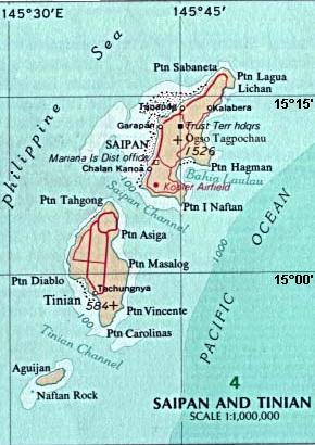
Tinian is one of the three principal islands of the Commonwealth of the Northern Mariana Islands (CNMI). Together with uninhabited neighboring Aguiguan, it forms Tinian Municipality, one of the four constituent municipalities of the Northern Marianas. Tinian's largest village is San Jose. Tinian is just south of the most inhabited island Saipan, but north of the populated Rota to the south. The island is home to many WW2 historical sites, cattle ranches, and beaches. There was a 5-star casino that operated from 1998 to 2015; remaining are other hotels/resorts and a golf course. The main access to Saipan is by a short airplane ride from the international airport, or by a charter boat.

The Mariana Islands, also simply the Marianas, are a crescent-shaped archipelago comprising the summits of fourteen longitudinally oriented, mostly dormant volcanic mountains in the northwestern Pacific Ocean, between the 12th and 21st parallels north and along the 145th meridian east. They lie south-southeast of Japan, west-southwest of Hawaii, north of New Guinea and east of the Philippines, demarcating the Philippine Sea's eastern limit. They are found in the northern part of the western Oceanic sub-region of Micronesia, and are politically divided into two jurisdictions of the United States: the Commonwealth of the Northern Mariana Islands and, at the southern end of the chain, the territory of Guam. The islands were named after the influential Spanish queen Mariana of Austria following their colonization in the 17th century.
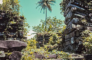
Nan Madol is an archaeological site adjacent to the eastern shore of the island of Pohnpei, now part of the Madolenihmw district of Pohnpei state in the Federated States of Micronesia in the western Pacific Ocean. Nan Madol was the capital of the Saudeleur dynasty until about 1628. The city, constructed in a lagoon, consists of a series of small artificial islands linked by a network of canals. The site core with its stone walls encloses an area approximately 1.5 km long by 0.5 km wide and it contains 92 artificial islets—stone and coral fill platforms—bordered by tidal canals.
The Micronesians or Micronesian peoples are various closely related ethnic groups native to Micronesia, a region of Oceania in the Pacific Ocean. They are a part of the Austronesian ethnolinguistic group, which has an Urheimat in Taiwan.

Chuuk State is one of the four states of the Federated States of Micronesia (FSM). The other states are Kosrae State, Pohnpei State, and Yap State. It consists of several island groups: Namoneas, Faichuuk, the Hall Islands, Namonuito Atoll, Pattiw, and the Mortlock Islands. Chuuk is by far the FSM's most populous state, with 50,000 inhabitants on 120 square kilometers. Chuuk Lagoon is where most people live. Weno island, in the lagoon, is Chuuk's state capital and the country's biggest city. It may hold a referendum on independence in the near future, although this referendum has been repeatedly postponed.

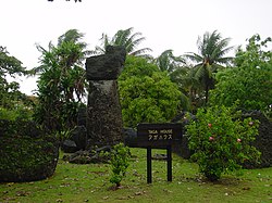
A latte stone, or simply latte, is a pillar capped by a hemispherical stone capital (tasa) with the flat side facing up. Used as building supports by the ancient Chamorro people, they are found throughout most of the Mariana Islands. In modern times, the latte stone is seen as a sign of Chamorro identity and is used in many different contexts.
The Saudeleur dynasty was the first organized government uniting the people of Pohnpei island, ruling from c. 1100-1200 CE to c. 1628 CE. The era was preceded by the Mwehin Kawa or Mwehin Aramas, and followed by Mwehin Nahnmwarki. The name Deleur was an ancient name for Pohnpei, today a state containing the capital of the Federated States of Micronesia.
Micronesian mythology comprises the traditional belief systems of the people of Micronesia. There is no single belief system in the islands of Micronesia, as each island region has its own mythological beings.

The Micronesian imperial pigeon, also known as the Micronesian pigeon, and Belochel is a species of bird in the family Columbidae (doves). It is found in Palau, the Caroline Islands, the Marshall Islands and Nauru. Its habitats include montane forests, secondary forests, forests on beaches, and mangroves. It is threatened by hunting and deforestation, and the IUCN has assessed it as a near-threatened species.

The Micronesian myzomela is a species of bird in the honeyeater family Meliphagidae. The species forms a superspecies with a number of related and similar looking island and mainland myzomelas across the Pacific and Australasia. It in turn is composed of seven insular subspecies.

Rota Latte Stone Quarry, also known as the As Nieves quarry, is located near the Chamorro village of Sinapalo, on the island of Rota in the Marianas Archipelago. The prehistoric megaliths found there are believed to have been used as foundation pillars for houses, with some of them weighing up to 35 tons. Their exact age, origin, methods of quarrying and means of transportation have not been determined.

The Laulau Kattan Latte Site is a prehistoric archaeological site on the island of Saipan in the Northern Mariana Islands. Located near the shore of Laulau Bay, it is a small village site containing the remains of four latte stone house foundations, and an extensive scattering of pottery artifacts. When first reported by the pioneering archaeologist Alexander Spoehr in the 1940s, the latte stones were described as mostly fallen over and extremely weathered.
The Unai Obyan Latte Site is a prehistoric archaeological site on the island of Saipan in the Northern Mariana Islands. Located near Obyan Beach on the south coast of the island, it is the site of what was once a fairly extensive village, which was significantly disturbed by Japanese defensive preparations during World War II. The site includes the fragmentary remains of a single latte stone house site and a wide scattering of surface-level remains. Excavation of the latte house site in the 1940s by the pioneering archeologist Alexander Spoehr yielded evidence of a length period of occupation. The village at Obyan was documented in early Spanish accounts of the island, and was probably abandoned when the Spanish forcibly relocated the entire island population to Guam in 1698.

Mochong is a major prehistoric archaeological site on the island of Rota in the Northern Mariana Islands. It is considered the best preserved and second largest latte village in the Marianas. It is an extensive village site on the northern side of the island comprising 50 individual latte sets, scattered mortars (lusongs), scattered subsurface artifacts such as tools, fishing implements and abundance pieces of pottery; the Marianas Red Ware Pottery and the Marianas Plain Ware Pottery. This site also includes an extremely rare latte house structure consisting of 14 columns. It also has a latte stone wall, consisting of six columns and five slabs, that is more than 50 feet (15 m) long. The site has been radiocarbon dated to c. 1000 BCE. The site was first sketched in the early 19th century by the French explorer Louis de Freycinet, and was in remarkably intact condition in the 1980s.
Don Allen Farrell is an educator, local historian and author based on the island of Tinian in the Commonwealth of the Northern Mariana Islands (CNMI). He is known for his research and publications on the history of the Mariana Islands with an emphasis on World War II.