
The following is an alphabetical list of articles related to the Commonwealth of the Northern Mariana Islands .
The following is an alphabetical list of articles related to the Commonwealth of the Northern Mariana Islands .

| | This section is empty. You can help by adding to it. (July 2010) |
| | This section is empty. You can help by adding to it. (July 2010) |
| | This section is empty. You can help by adding to it. (July 2010) |
| | This section is empty. You can help by adding to it. (July 2010) |

| | This section is empty. You can help by adding to it. (July 2010) |
| | This section is empty. You can help by adding to it. (July 2010) |
![]() Wikimedia Atlas of the Northern Mariana Islands
Wikimedia Atlas of the Northern Mariana Islands

The Northern Mariana Islands, officially the Commonwealth of the Northern Mariana Islands, is an unincorporated territory and commonwealth of the United States consisting of 14 islands in the northwestern Pacific Ocean. The CNMI includes the 14 northernmost islands in the Mariana Archipelago; the southernmost island, Guam, is a separate U.S. territory. The Northern Mariana Islands were listed by the United Nations as a non-self governing territory until 1990.

Saipan is the largest island of the Northern Mariana Islands, a commonwealth of the United States in the western Pacific Ocean. According to 2020 estimates by the United States Census Bureau, the population of Saipan was 43,385, a decline of 10% from its 2010 count of 48,220.
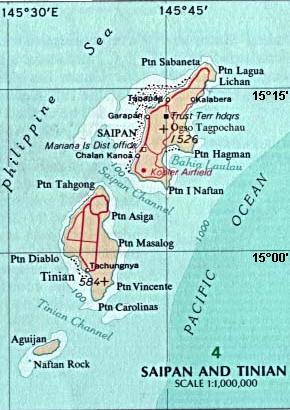
Tinian is one of the three principal islands of the Commonwealth of the Northern Mariana Islands. Together with uninhabited neighboring Aguiguan, it forms Tinian Municipality, one of the four constituent municipalities of the Northern Marianas. Tinian's largest village is San Jose.

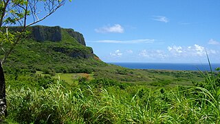
The Mariana Islands, also simply the Marianas, are a crescent-shaped archipelago comprising the summits of fifteen longitudinally oriented, mostly dormant volcanic mountains in the northwestern Pacific Ocean, between the 12th and 21st parallels north and along the 145th meridian east. They lie south-southeast of Japan, west-southwest of Hawaii, north of New Guinea and east of the Philippines, demarcating the Philippine Sea's eastern limit. They are found in the northern part of the western Oceanic sub-region of Micronesia, and are politically divided into two jurisdictions of the United States: the Commonwealth of the Northern Mariana Islands and, at the southern end of the chain, the territory of Guam. The islands were named after the influential Spanish queen Mariana of Austria following their colonization in the 17th century.

Farallón de Pájaros, also known as Uracus or Urracas, is a small (2.3 km2) uninhabited volcanic island, the northernmost island in the Northern Mariana Islands chain.

Anatahan is an island in the Northern Mariana Islands in the Pacific Ocean, and has one of the most active volcanoes of the archipelago. Although formerly inhabited, the island is currently uninhabited due to the constant danger of volcanic eruptions. Anatahan is located 60 kilometers (32 nmi) northwest of Farallon de Medinilla and 120 km (65 nmi) north of Saipan.

Maug consists of a group of three small uninhabited islands. This island group is part of the Northern Islands Municipality of the Commonwealth of the Northern Mariana Islands, itself part of the Marianas archipelago in the Oceanian sub-region of Micronesia.

Asuncion is the third northernmost island in the Northern Mariana Islands chain in the Pacific Ocean. The island is uninhabited. Asuncion is situated 101 kilometers (63 mi) northwest of Agrihan and 37 km (23 mi) southeast of the Maug Islands.

Zealandia Bank, also known as Farallon de Torres or Piedras de Torres in Spanish, or Papaungan in Chamorro, consists of two rocky pinnacles about 1.5 kilometers apart, in the Northern Mariana Islands in the Pacific Ocean. One reaches a height of approximately 1 meter (3.3 ft) at low tide; the other does not normally broach the surface. They are located 11 nautical miles (20 km) north-northeast from Sarigan, in between Sarigan and Guguan, but because of their small size, they are not listed in most maps. Zealandia Bank is one of a number of Volcanic Units within the Mariana Arc of Fire National Wildlife Refuge of the Marianas Trench Marine National Monument.

Alamagan is an island in the Northern Mariana Islands in the Pacific Ocean, 30 nautical miles (56 km) north of Guguan, 250 nautical miles (463 km) north of Saipan, and 60 nautical miles (111 km) south of Pagan. It is currently uninhabited.

Sarigan or Sariguan is an uninhabited volcanic island in the Pacific Ocean. It is part of the Northern Mariana Islands, a U.S. territory. Sarigan is located 37 kilometers (20 nmi) northeast of Anatahan island, 67 km (36 nmi) south of Guguan and 150 km (81 nmi) north of Saipan, the largest island in the Northern Marianas.
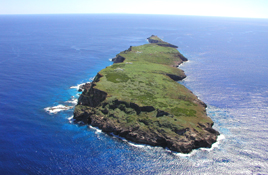
Farallon de Medinilla , also known as No'os, is a small uninhabited island in the Northern Mariana Islands in the Pacific Ocean. It is located 45 nautical miles (83 km) north of Saipan and is the smallest island in the archipelago. Politically, it is part of the Northern Islands Municipality.
Northern Islands Municipality is one of the four main political divisions of the Commonwealth of the Northern Mariana Islands. It consists of a long string of the northernmost islands of the Northern Marianas, including Farallon de Pajaros, the Maug Islands, Asuncion, Agrihan, Pagan, Alamagan, Guguan, Zealandia Bank, Sarigan, Anatahan, and Farallon de Medinilla. The total land area of the islands, including offshore islets and rocks, is 154.755 km².
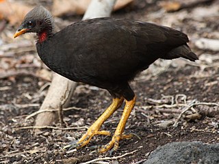
The Micronesian megapode or Micronesian scrubfowl is an endangered megapode which inhabits islands of the Western Pacific Ocean.
The following outline is provided as an overview of and topical guide to the Northern Mariana Islands:

The following is an alphabetical list of articles related to the United States Territory of Guam.
The Marianas tropical dry forests is a tropical and subtropical dry broadleaf forests ecoregion on the Marianas Islands in the western Pacific Ocean.

US Naval Base Marianas was number of United States Navy bases in the Mariana Islands in the Pacific Ocean's Micronesia. Most were built by the US Navy Seabees, Naval Construction Battalions, during World War II. Naval Base Guam was lost to the Empire of Japan during the Battle of Guam in December 1941. Gaum was retaken by United States Armed Forces on July 21, 1944, now also known as Liberation Day. Naval Station Guam was founded on August 7, 1899, after Spain lost the Spanish–American War.