
Garapan is the largest village and the center of the tourism industry on the island of Saipan, which is a part of the United States Commonwealth of the Northern Mariana Islands (CNMI). Garapan, as a census-designated place, has an area of 1.2 km2 (0.46 sq mi) and a population of 3,588.

This is a list of the buildings, sites, districts, and objects listed on the National Register of Historic Places in the Northern Mariana Islands. There currently 37 listed sites spread across the four municipalities of the Northern Mariana Islands. There are no sites listed on any of the islands that make up the Northern Islands Municipality.

St. Joseph's Roman Catholic Church is a historic church at 86 Hope Street in Providence, Rhode Island within the Diocese of Providence.
The Catholic Belltower is a historic tower at the Catholic Mission in Kolonia, on the island of Pohnpei in the Federated States of Micronesia. The belltower and adjoining masonry apse are all that remain of a church built in 1909 by German and Spanish Capuchin missionaries, when Ponape and the other Caroline Islands were administered as part of German New Guinea. The rest of the church was destroyed during the fighting of World War II. The tower is 4.8 metres (16 ft) square, rising to a height of 20.7 metres (68 ft), and the shell of the apse is about 10 metres (33 ft) in height. The tower has a foundation of basalt rock and lime mortar, and is constructed out of concrete bricks.

The Japanese Lighthouse is an abandoned lighthouse situated atop Navy Hill in Garapan, Saipan, in the Northern Mariana Islands. It was listed on the National Register of Historic Places in 1974. The lighthouse is one of the few surviving pre-World War II, civilian structures built by the Japanese.

The Japanese Coastal Defense Gun near Songsong on Rota in the Northern Marianas Islands, is a historic site that is listed on the U.S. National Register of Historic Places. The gun emplacement was built by the Japanese military in 1941. It was listed on the National Register in 1984.
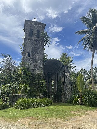
The Japanese Hospital or Saipan Byoin is a historic World War II-era hospital complex on Route 3 in Garapan, a village on the island of Saipan in the Northern Mariana Islands. The three concrete buildings are the largest Japanese-built structures to survive the war. The main hospital building is an L-shaped structure with a domed entrance at the crook of the L. A second, smaller building housed the pharmacy, while the third is an underground circular chamber of unknown purpose. All were in deteriorating condition when surveyed in the early 1970s. The complex has since undergone restoration, and the main hospital building now houses the Northern Mariana Islands Museum.

The Merizo Bell Tower, on Guam Highway 4 in Merizo, Guam, is a bell tower that was built in 1914 or 1919. It was listed on the U.S. National Register of Historic Places in 1975.
The Japanese Lighthouse, or Poluwat Lighthouse, is an abandoned lighthouse situated on Alet Island in Poluwat, Chuuk in the Federated States of Micronesia. It was completed in 1940 by the Japanese and was in use until being attacked by U.S. forces in World War II. It was listed on the National Register of Historic Places in 1983. The lighthouse is a good example of pre-World War II "marine architecture" built by the Japanese.

St. Mary of the Visitation Catholic Church is a historic church in Huntsville, Alabama and is the oldest Catholic church in North Alabama. It began construction in 1861 but was interrupted by the Civil War. The church was completed in 1877. It was listed on the National Register of Historic Places in 1980.
The Commissioner's Office is a rare surviving example of transitional Spanish-Japanese architecture on the island of Rota in the Northern Mariana Islands, an insular area of the United States in the western Pacific Ocean. It is a single-story structure with walls of manposteria, a construction method adopted during the Spanish period. The window trim consists of ifil lintels, and the building's cornice is Japanese in style. At the time of the building's listing on the National Register of Historic Places in 1981, it was in deteriorated condition, lacking a roof and with one collapsed wall. The structure was built in the 1930s by the local Chamorro people, who had been displaced to that part of the island by Japanese settlement undertaken as part of the South Seas Mandate. The building housed the offices of a local commissioner, or village head responsible to the Japanese authorities. Many buildings built by the Japanese during the mandate period were destroyed in World War II.

The Chugai' Pictograph Site is a prehistoric rock art site on the island of Rota in the Northern Mariana Islands. The rock art is located in a limestone cave on the southeastern side of the island, in the I'Chenchon Bird Sanctuary. It consists of a large panel, 185 feet (56 m) in length, of about 90 painted drawings, believed to be of late pre-contact origin. The site is accessed via a trail cut by the Japanese during the South Seas Mandate period.
The Hachiman Jinja (彩帆八幡神社) is a derelict Shinto shrine off Kagman Road on the island Saipan in the Northern Mariana Islands, and one of the few on those islands to survive relatively intact. The shrine, dedicated to the kami Hachiman, was probably built in the 1930s by the Japanese administration of the South Seas Mandate as part of a program to Japanize the large number of Ryukyuan and Korean workers on the island. The shrine survived the World War II Battle of Saipan in remarkably good condition, although its main torii fell, and two komainu were lost. The main honden received some maintenance in the 1970s, and the property has received some maintenance from a local landholder. As of 2019, it is in total disrepair.

The Japanese 20mm Cannon Blockhouse is one of many relics of World War II on the island of Saipan in the Northern Mariana Islands. It is a concrete blockhouse, semi-circular in shape with a diameter of about 6 metres (20 ft). Its walls are 1.22 metres (4.0 ft) thick with four firing ports large enough to accommodate 20mm cannons, originally equipped with steel sliding shutters. A steel door 25 millimetres (0.98 in) thick provides access to the structure at the rear, sheltered by a concrete wall and covered defensively by a machine gun port. The blockhouse is located near the center of what is locally called Big Agingan Beach, on the south coast of the island, about 20 metres (66 ft) from the shore. It was built in some haste by the Japanese forces defending Saipan in 1944, and was captured by Allied forces early in the Battle of Saipan.
The Waherak Maihar is a historic outrigger canoe on the island of Saipan in the Northern Mariana Islands. Built in 1958, it is a well-preserved example of a traditional Caroline Islands ocean-going canoe. It is 26 feet (7.9 m) long with a beam of 3 feet (0.91 m). It was constructed by the islanders of Poluwat from native materials, including coconut, pandanus, and breadfruit.
The former Japanese Hospital building on the island of Rota in the Northern Mariana Islands is one of the few remaining Japanese-era buildings on the island. It is a single-story L-shaped concrete structure. When listed on the National Register of Historic Places in 1981, it was described as being in derelict condition, being little more than the concrete structure, lacking a roof, windows, and most of its woodwork. The window openings are sheltered by typical Japanese concrete canopies. The building was built by the Japanese about 1930, during the South Seas Mandate period; most Japanese-built structures on Rota were destroyed during World War II.
The Nan'yō Kōhatsu Kabushiki Kaisha complex was the main support base of the Nan'yō Kōhatsu Kabushiki Kaisha (NKKK) on the island Tinian in the Northern Mariana Islands. The NKKK was an economic development company established by the Empire of Japan to develop the territories of the South Seas Mandate, which it oversaw between the First and Second World Wars. In the Northern Marianas, the company aggressively developed arable areas for sugar cane farming, importing workers from Japan, Okinawa, and Korea. Each of the three major islands had major support facility. On Tinian, this area, now roughly where the island's largest community, San Jose is located on the south coast, consisted of an extensive development, most of which was destroyed during the Battle of Tinian in the Second World War. Of this large complex, only four buildings or structures remain, all of which have been listed on the United States National Register of Historic Places, as rare surviving examples of pre-war Japanese architecture on the islands.
The Rectory on the island of Rota in the Northern Mariana Islands is a rare example of transitional Spanish-Japanese architecture in the archipelago, now a United States commonwealth. It was built about 1930, during the South Seas Mandate period of Japanese administration, when the native Chamorro people were displaced to this area by workers imported by the Japanese to work in the sugar fields. The rectory is an L-shaped concrete structure measuring 13.7 by 19.8 metres, and originally had a wood-framed second floor and roof. Although only the concrete frame remains, elements such as its massive steps and window placement are typical of the earlier Spanish period, while decorative elements such as its porch columns and window opening details are distinctly Japanese.

The Nan'yō Kōhatsu Kabushiki Kaisha Sugar Mill is a former industrial facility in the village of Songsong on the island of Rota in the Northern Mariana Islands. Its ruins are a significant reminder of the South Seas Mandate period, when Imperial Japan engaged in large-scale sugar cane farming in the Northern Marianas, and are the only brick structure in the Northern Marianas. The sugar mill on Rota was one of the major installations of the Nan'yō Kōhatsu Kabushiki Kaisha, the Japanese company responsible for economic development of the mandate area. Its Executive Director turned Board Chairman. Haruji Matsue, considered the Northern Mariana Islands, the best place to establish the sugar industry, and more especially since previous Japanese commercial enterprises tried their hand at growing and processing sugar cane, but failed. The Nan'yō Kōhatsu Kabushiki Kaisha, was the most dominant economic force and being the largest Japanese Corporation, came to the Northern Marianas in 1921. Not unlike its predecessors, the NKK experienced a very tough few years, which almost forced the company to cease operations. Things started to take a turn for the better in 1926. By the early 1930s, Matsue proceeded to expand the company's landholdings and operations to Tinian and Rota, respectively. Rota had one mill and 38% of the farmlands had sugar cane growing. The remnants of this sugar mill, all that survived the Allied capture of Rota during World War II, are located on the north side of the peninsula that projects southwest from Songsong, and consist of fragments of brick and concrete structures. The most impressive single element is a brick and concrete tunnel 42.5 metres (139 ft) long, from which openings lead to the locations of other parts of the once-extensive complex.

Gadao's Cave, also known as Liyang Gadao, is a rock art site on the United States island of Guam. Located near the village of Inarajan, the cave is the site of a panel of approximately 50 Chamorro pictographs, painted with a mixture of coral lime and tree sap. The most unusual images are of two human stick figures that appear to be carrying things. It is not known who painted them or when, and what their significance is. The legendary chief of Inarajan Gadao is believed to be the creator of the cave's images.


